The grantee of a water lot, bounded on the shore, is entitled to take up to high-water mark; and that line of his grant changes with the gradual encroachment or retirement of the sea.
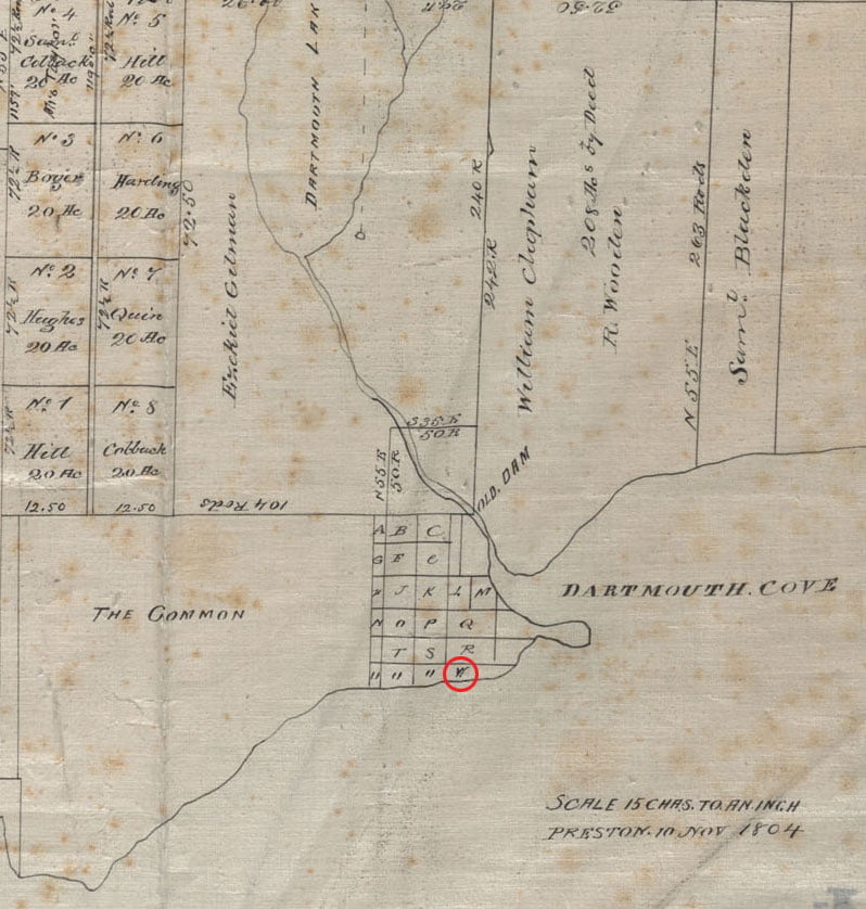
…The plantiff derived his title to the land in question through several mesne conveyances, from Mrs. Jane Donaldson. She, it appears, was, in 1818, and previously thereto, in possession of lots Nos. 4, 5 and 6, in division letter W, in the town plot of Dartmouth“
Thomson, James. “Law reports : containing decisions of the Bench of the Supreme Court in Nova-Scotia between the years 1834 and 1841” [Halifax, N.S.? : s.n.], 1853 (Halifax, N.S. : R. Nugent) https://www.canadiana.ca/view/oocihm.67192/1?r=0&s=1
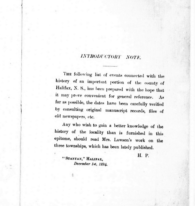
Between 1746 and 1894, Dartmouth’s history unfolds with significant events including the arrival of settlers, establishment of saw-mills, and conflicts with the Mi’kmaq people. Dartmouth saw fluctuations in population, the building of churches and other infrastructure, and incorporation as a town in 1873. Economic activities like shipbuilding, ferry services, and the discovery of gold at Waverley mark periods of prosperity. However, tragedies such as fires, mysterious disappearances, and drowning incidents also punctuate Dartmouth’s timeline.
The town experienced advancements such as the introduction of steamboats, electricity, and the establishment of amenities like bathing houses and public reading rooms. Infrastructure projects like railway construction, water supply, and sewerage systems reflect efforts to modernize Dartmouth. Despite setbacks like bridge collapses and refinery closures, the town continued to evolve and grow, reaching a population of over 6,000 by 1891.
1746-1799
Duc d’Anville arrived at Chebucto, 10 Sept 1746
Halifax founded, 21 June 1749
[Mi’kmaq] attacked 6 men at Maj. Gilman’s saw-mill, Dartmouth Cove, killing 4, 30 Sept 1749
After piecing together several Crown land grant maps, you can see the path of the Old Annapolis Road much more clearly. Open the image in a new tab, to see it in more detail.
Below you’ll find a few representations of the road as a contiguous route, as opposed to what is left recorded on the Crown Land Grant maps. (You can find find the individual Crown Land Grant maps here: https://novascotia.ca/natr/land/grantmap.asp)
Previous to the construction of the more direct route to Annapolis, this map from 1776 shows a road (from Dartmouth, certainly an error, likely from Fort Sackville at the head of the harbor) to Annapolis. “A general Map of the northern British Colonies in America which comprehends the province of Quebec, the government of Newfoundland, Nova Scotia, New England and New-York” https://gallica.bnf.fr/ark:/12148/btv1b8443126p
One of the first representations of the Old Annapolis Road, “Road markt out by Gov. Parr’s orders in 1784”
“The Provinces of Lower & Upper Canada, Nova Scotia, New Brunswick, Newfoundland & Prince Edward Island with a large section of the United States”, 1831. https://gallica.bnf.fr/ark:/12148/btv1b530987207
Annapolis Road pieced together from several pages of the “Atlas of the Maritime Provinces of the Dominion of Canada”, Roe Brothers, St. John, NB 1878. https://www.islandimagined.ca/roe_atlas
Fifteen years later, by 1927, the Old Annapolis Road disappears from the maps. Perhaps it wasn’t fit for automobile travel, though it’s hard not to notice the change (back?) to “Annapolis Royal” from “Annapolis” occurred at the same time.
Much of the road is now incorporated into other routes. It’s the #8 from Annapolisthrough Lequille, it’s the West Dalhousie Road through to Lake La Rose and from West Dalhousie to Albany Cross on to Stoddard’s where it once continued straight at what is now a turn (see above at 1876). It then crossed over the brook that empties into Upper Thirty Lake, from there it continued across another bridge, this time over the LaHave River to connect to what is now Camel Hill Road. The route proceeded to where it now meets Cherryfield Road and becomes Dalhousie Road, and on eastwards from there, through to Franey Corner and on to New Ross. At this point the route seems to have been reclaimed by the woods somewhat but it continued south and east near Sherwood, and then north of Canaan and Timber Lake, to the south of Panuke Lake (once called “Carrying Place”, see above at 1864) near Simms Settlement, through the country between Sandy and Rafter lake then terminating at Pockwock Road, north of Wrights Lake in Upper Hammonds Plains.
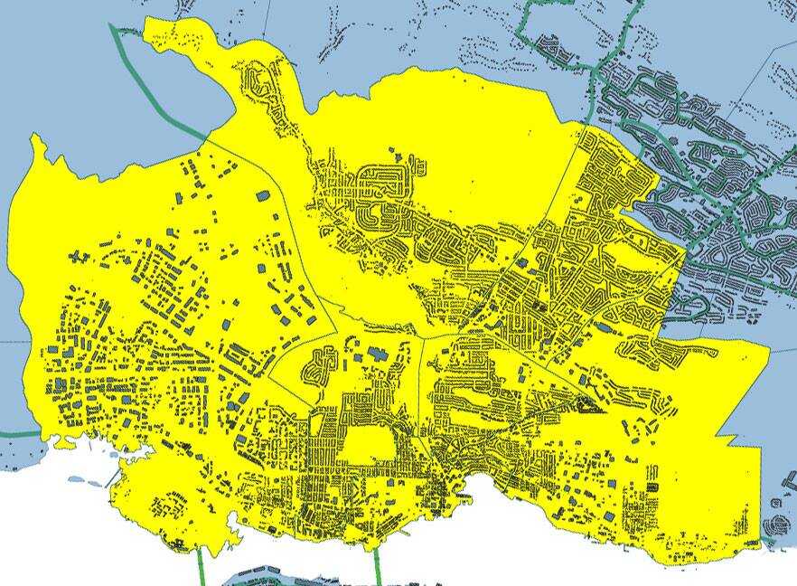
An examination of the legislated spatial dimensions of Dartmouth – from its initial definition as a township care of the Royal instructions that accompanied Cornwallis in 1749 to its dissolution in one of Nova Scotia’s city county mergers by fiat (aka a “municipal coup”) in 1996.
“And whereas for the better security, regulation and government of our said settlement, it will be necessary that such persons as we shall judge proper to send to our said province should be settled in townships; you are therefore hereby authorized and required to appoint such proper persons as you shall find there fully qualified to carry along with you forthwith to survey and mark out the said townships in such manner and at such places as is herein directed, that is to say, two townships containing 100,000 acres of land each be marked out at or near our harbor of Chebucto, as also one township of the like extent at each of the aforementioned places or such others as you shall judge most proper; and you are to take particular care in laying out such townships that they do include the best and most profitable land and also that they do include the best and most profitable rivers as may be at or near the said settlements and that the said townships do extend as far up into the country as conveniently may be, taking in a necessary part of the seacoast”.
“That the Township of Dartmouth comprehend all the Lands lying on the East Side of the Harbour of Halifax and Bedford Basin, and extending and bounded Easterly by the Grant to the Proprietors of Lawrence-Town, and extending from the North-easterly Head of Bedford Basin into the Country, until One Hundred Thousand Acres be comprehended.”
“Common of the town of Dartmouth…the common of the township of Dartmouth; situate on the eastern side of the harbour of Halifax, in special trust, for the use of the inhabitants settled and resident in the town plot, or that might thereafter settle, and actually reside, within the township of Dartmouth… Within the township of Dartmouth”
Chapter 2 of the Acts of 1797, “An act to enable the Governor, Lieutenant Governor, or Commander in chief for the time being, to appoint Trustees, for the Common of the Town of Dartmouth, on the death, or removal, of the Trustees holding the same, and to vacate that part of the grant of the Common aforesaid, which vests trust in the heirs, executors or administrators, of the Trustees, named in the said grant, on the death of such Trustees” http://0-nsleg–edeposit.gov.ns.ca.legcat.gov.ns.ca/deposit/Statutes/at_large/volume1/1797.pdf
“Town plot of Dartmouth… The said town… The town plot of Dartmouth, bounded on the North by the Common, on the South and West by the Halifax Harbour, and on the east by Mill Brook… Of the said towns respectively, within the said limits.”
“the Town of Dartmouth… inhabitants of the said town… the jurisdiction, powers and authority, of the commissioners so to be appointed for the said Town of Dartmouth, shall be confined and restricted to the bounds and limits following, that is to say:— to the direction or space of one Mile, measured in a southwardly, Easterly, and Northerly direction, from the Public Landing, or Steam Boat Company Wharf, in the said Town.”
“Whereas some uncertainty exists as regards the limits of the Township of Dartmouth… Be it therefore enacted by the Lieutenant Governor, Council and Assembly, that the lines of the Township of Dartmouth shall be established and settled as follows, beginning on the Eastern side of Bedford Basin at the head of Pace’s cove at low water mark, and thence to run north seventy four degrees east until it meets the main stream running Into Lake Major, thence southerly through the center of Lake Major and West Salmon River to the waters of Cole Harbor and thence Southwestwardly along the shore the several courses of the shore to Roaring Point, thence northerly following the course of the shore of the Main Land at low water mark to the place of beginning, so as not to include any Islands lying on or near said shore.
“…the inhabitants of the said town of Dartmouth …within the space of one mile, measured in a southwardly, easterly and northerly direction from the public landing or Steamboat Company’s wharf in said town”
For Dartmouth…one mile, measured in a southwardly, easterly and northerly direction from the public landing or Steamboat Company’s wharf in the said Town”
“After the first Annual Town Meeting in the Township of Dartmouth, Three Trustees of Public Property shall be chosen, in whom shall be vested the legal possession of the several Water Lots that have been reserved for the use of the Public along the shores of the Town Plot of Dartmouth, and of a certain Lot of Land and School House now known and distinguished as the School Lot, lying in the Town Plot, to be recovered, held and preserved by the Trustees for the uses to which the same respectively have been reserved and applied, but the School House and School Lot shall be preserved exclusively to the use of Schools and Education, and nothing herein shall excuse the possession and control of the Trustees to be appointed under the Act passed in the present Session for the support of Schools if the School House and Lot might otherwise come under control of such Trustees. Any other Public Property in the Township of Dartmouth not legally possessed by or under the charge and supervision of any person, shall also be legally vested in the Trustees appointed under this act… three trustees shall be annually thereafter appointed at each Annual Town Meeting of the Township… The Inhabitants, in Town Meeting, at any time may declare the purposes to which the Town Property shall be applied by the Trustees, provided those purposes shall not be inconsistent with the uses to which the property has been granted, reserved or legally appropriated… the next Annual Town Meeting of Dartmouth”
“The rateable inhabitants residing within the town plot of the township of Dartmouth, in the county of Halifax, may assess themselves, at any public meeting… for the purpose of obtaining a good and sufficient plan of said town plot… the inhabitants of the said town plot… The Commissioner of Streets for the said township…”
“The Trustees of the Dartmouth Common shall be a Body politic and corporate… the Commissioner of Streets for the Town of Dartmouth… A requisition signed by two thirds at least of the rate payers residing within the limits of the town plot of Dartmouth… Which town plot shall be construed to embrace an area within a distance of one mile measured in a southwardly, easterly and northerly direction from the public landing or Steamboat Company’s wharf in said town”
‘A municipality shall be erected within the County of Halifax, to be bounded as follows, that is to say: Beginning on the eastern side of the Harbor of Halifax, at a point in such Harbor distant three hundred feet Westerly from the South Western corner of a lot of land formerly owned by Judge Johnston and by him conveyed to John Esdaile; thence to run Eastwardly till it strikes the road leading to the property of the late John Esson; thence by the Southern side of such road and following the course thereof Eastwardly to such Esson property; thence along the Western boundary of such property, Southwardly to the South-Western corner thereof; thence Eastwardly to Gaston’s Road, and crossing such road to a point at right angles with the extension of a new road laid out by J.W. Watt through manor Hill Farm; thence Northwardly to such road and by such road for the length thereof; thence Northwardly to the causeway at Hurley’s on the First Lake; thence Northwardly to the North East boundary of Stair’s Ropewalk property; thence Westwardly to a point three hundred feet into the Harbor of Halifax; and thence Southwardly to then place of beginning; to be called and known as “The Town of Dartmouth”‘.
The inhabitants of the town of Dartmouth are constituted and declared to be a body corporate and politic by the name of the Town of Dartmouth. They shall as a corporation have perpetual succession and a Common Seal, changeable at pleasure, and shall be capable of suing and being sued in all Courts of Justice, and of acquiring, holding and conveying any description of property, real, personal or mixed, and shall have all the other rights usually had and enjoyed by corporations.
The Town of Dartmouth shall be bounded as follows:—
Beginning on the eastern side of the Harbor of Halifax, at a point in such Harbor distant three hundred feet Westerly from the South Western corner of a lot of land formerly owned by Judge Johnston and by him conveyed to John Esdaile; thence to run Eastwardly till it strikes the road leading to the property of the late John Esson; thence by centre of such road and following the course thereof Eastwardly to such Esson property; thence along the Western boundary of such property, Southwardly to the South-Western corner thereof; thence Eastwardly to Gaston’s Road, and crossing such road to a point at right angles with the extension of a new road laid out by J.W. Watt through manor Hill Farm; thence Northwardly to such road and by such road for the length thereof; thence Northwardly to the western extremity of the causeway at Hurley’s on the First Lake; thence Northwestardly through Taylor’s barn on the opposite side of the lake until it strikes the Southern side line of the road which connects with the new road laid out by G. A. S Chichton, thence following the southern line of said road until it reaches the main road leading from Dartmouth to Bedford; and from thence crossing said road in a straight line following the said line of the said new road until it extends three hundred feet into the harbor of Halifax, and thence Southwardly to the place of beginning to be called and known as “The Town of Dartmouth”.
“The inhabitants of the town of Dartmouth are constituted and declared to be a body corporate and politic by the name of the Town of Dartmouth, and the boundaries of the town of Dartmouth, the division of the same into wards, and the boundaries of the several wards thereof, shall continue as at the passing of this Act.”
Chapter 86 of the acts of 1886, “An Act to Amend the Acts relating to the Town of Dartmouth”
[Included is a copy of the 1886 Statues from archive.org, since the copy supplied by the Government of Nova Scotia is missing page 253, which just so happens to be paragraph 1-3 of this Act to Amend the Acts relating to the Town of Dartmouth, which contains the above quoted passage, along with an explicit mention of male or female ratepayers, residents and nonresidents as qualified to vote.]
“The Dartmouth Ferry Commission shall continue to be a body politic and corporate, as constituted under chapter 83 of the Acts of 1890 and amending Acts.”
Beginning at a point in the harbor of Halifax distant three hundred feet westerly from the southwestern corner of a lot of land formerly owned by the late Judge Johnstone, and by him conveyed to John Esdaile; thence eastwardly to the road leading to the property of the late John Esson; thence by the centre of such road and following the course thereof eastwardly to such Esson property; thence along the Western boundary of such property southwardly to the southwestern corner thereof; thence eastwardly to the eastern side of Gaston’s Road; thence in a straight line to the point of intersection of the eastern side line of a new road laid out by J. W. Watt through Manor Hill farm, and the northern side line of Cole Harbor Road; thence northwardly by the said new road for the length thereof; thence northwardly to the western extremity of the causeway at Hurley’s on the first lake; thence northwestwardly through Taylor’s born on the opposite side of the lake until it strikes the southern line of the road which connects with the new road laid out by G. A. S. Chrichton; thence following the southern side of said road until it reaches the main road leading from Dartmouth to Bedford, and from thence crossing said road in a straight line following the said line of the said new road until it extends three hundred feet into the harbor of Halifax; thence southwardly in a line parallel to the shore of the harbor, and distant three hundred feet therefrom to the place of beginning. (1873, c. 17, s. 1; 1877, c. 40; 1897, c. 50, s. 3)
Beginning at the point of intersection of ordinary high water mark on the eastern shore of Halifax Harbor with the prolongation south-westerly of the centre line of a stone wall defining the south-eastern boundary of a lot of land formerly owned by the late Judge Johnstone and by him conveyed to John Esdaile; thence north-easterly along said prolongation and the centre line of said stone wall 1084 feet to a monument on the eastern line of Pleasant Street; thence 52 degrees 22 minutes right, 880.9 feet to a monument; thence 38 degrees 24 minutes left, 826.8 feet to a monument on the south western boundary of the Esson farm; thence 76 degrees 48 minutes right along the southwestern boundary of said Esson Farm 1097.5 feet to a monument; thence 89 degrees 49 minutes left 1799 feet to a monument on the southeastern boundary of the Dartmouth Rod and Gun club; thence 86 degrees 50 minutes left along the rear line of properties situated on the southern side of Gaston Road, and crossing Gaston Road 1322.4 feet to a monument in rear of Atwood’s house on Gaston Road; thence 10 degrees 22 minutes right crossing Cole Harbor Road and along the eastern side of Watt Street 2411.2 feet to a monument on the southern line of Maynard Street; thence 11 degrees 7 minutes right crossing Oat Hill Lake, 2628 feet to a monument on the southwestern corner of the causeway on the Preston or Lake Road near Robert Carter’s; thence 13 degrees 32 minutes left, crossing Banook Lake 4757 feet to a monument on the southwestern corner of Crichton Avenue and Albro Lake Road; thence 10 degrees 19 minutes left along the southwestern side of Albro Lake Road 1085.8 feet to a monument; thence 88 degrees 25 minutes left along the south-eastern side of Albro Lake Road 2061.6 feet to a monument; thence 42 degrees 40 minutes right along the southern side of Albro Lake Road 400 feet to a monument; thence 19 degrees along the south side of Albro Lake Road 841 feet to a monument; thence 26 degrees 27 minutes left along the southeastern side of Albro Lake Road 1328.5 feet to a monument on the eastern line of Wyse Road at the point of intersection with the prolongation easterly of the northern side of the stone wall on the southern side of Albro Lake Road; thence 19 degrees 50 minutes right along the northern side of the stone wall on the southern side of Albro Lake Road 877.9 feet to a monument on the eastern side of Windmill Road; thence 6 degrees 30 minutes left, 1030 feet more or less to ordinary high water mark; thence in a general southerly direction along the shore of Halifax Harbor, as defined by ordinary high water mark, to the place of beginning, together will all water grants, docks, quays, slips and erections connected with the shores of the town which shall be deemed to be included in the boundaries and form part of the town.
Beginning at the point of intersection of ordinary high water mark on the eastern shore of Halifax Harbor with the prolongation south-westerly of the centre line of a stone wall defining the south-eastern boundary of a lot of land formerly owned by the late Judge Johnstone and by him conveyed to John Esdaile;
Thence north-easterly along said prolongation and the centre line of said stone wall 1084 feet to a monument on the eastern line of Pleasant Street;
Thence southerly along the eastern line of Pleasant Street to the northern line of Johnstone avenue and northern line of Esson Road to the south western boundary of the “Esson farm”;
Thence southeasterly along the southwestern boundary of the “Esson Farm” 100 feet (one hundred) more or less to a monument;
Thence continuing southeasterly along the southwestern boundary of the “Esson Farm” 1097.5 feet to a monument;
Thence 89 degrees 49 minutes left 1799 feet to a monument on the southeastern boundary of the Dartmouth Rod and Gun club;
Thence 86 degrees fifty minutes left along the rear line of properties situated on the southern side of Gaston Road, and crossing Gaston Road 1322.4 feet to a monument in rear of Atwood’s house on Gaston Road;
Thence 10 degrees 22 minutes right crossing Cole Harbor Road and along the eastern side of Watt Street 2411.2 feet to a monument on the southern line of Maynard Street;
Thence 11 degrees 7 minutes right crossing Oat Hill Lake, 2628 feet to a monument on the southwestern corner of the causeway on the Preston or Lake Road near Robert Carter’s;
Thence 13 degrees 32 minutes left, crossing Banook Lake 4757 feet to a monument on the southwestern corner of Crichton Avenue and Albro Lake Road;
Thence 10 degrees 19 minutes left along the southwestern side of Albro Lake Road 1085.8 feet to a monument;
Thence 88 degrees 25 minutes left along the south-eastern side of Albro Lake Road 2061.6 feet to a monument;
Thence 42 degrees 40 minutes right along the southern side of Albro Lake Road 400 feet to a monument;
Thence 19 degrees along the south side of Albro Lake Road 841 feet to a monument;
Thence 26 degrees 27 minutes left along the southeastern side of Albro Lake Road 2700 feet to a monument;
Thence 3 degrees 43 minutes right along the southern side of Albro Lake Road 1328.5 feet to a monument on the eastern line of Wyse Road at the point of intersection with the prolongation easterly of the northern side of the stone wall on the southern side of Albro Lake Road;
Thence 19 degrees 50 minutes right along the northern side of the stone wall on the southern side of Albro Lake Road 877.9 feet to a monument on the eastern side of Windmill Road;
thence 6 degrees 30 minutes left, 1030 feet more or less to ordinary high water mark;
thence in a general southerly direction along the shore of Halifax Harbor, as defined by ordinary high water mark, to the place of beginning, together will all water grants, docks, quays, slips and erections connected with the shores of the town which shall be deemed to be included in the boundaries and form part of the town.
The Town of Dartmouth shall continue to be a body corporate under the name “City of Dartmouth” .
The boundaries of the City are as follows:-
Beginning at a point defined by the intersection of the centre line of Wright Brook (at its mouth) with the shoreline of Wright Cove on the north-eastern shore of Bedford Basin;
Thence generally north-easterly along the centre line of Wright Brook to its intersection with the north-western boundary of the Canadian National Railways Right-of-way;
Thence generally north-easterly along the north-western boundary of the said Canadian National Railways Right-of-way to its first intersection with the centre line of McGregor Brook;
Thence generally south-easterly crossing the Canadian National Railways Right-of-way and along the centre line of McGregor Brook to its origin approximately at grid point 52.4 by east 54.7 (Department of Mines and Surveys Map, Bedford Basin, Scale 1 to 25,000) which aforesaid water course flows generally south-easterly into Lake Charles;
Thence generally south-easterly along the centre line of aforesaid Water Course to its mouth on the western shore oof Lake Charles;
Thence easterly along a straight line to the general centre of Lake Charles easterly from the mouth of the aforesaid water course;
Thence northerly along the general centre line of Lake Charles to the northern shore of Lake Charles at its junction with the centre line of the mouth of the northerly water course leading from Lake Charles to Lake William;
Thence generally northerly along the centre line of the aforesaid water course to its intersection with the southern boundary of the Nova Scotia Light and Power Company limited transmission line right-of-way;
Thence easterly along the aforesaid water course to its intersection with the southern boundary of the Nova Scotia Light and Power Company Limited transmission line right-of-way;
Thence easterly along the aforesaid southern boundary of the Nova Scotia Light and Power Company Limited transmission line right-of-way to a point on said southern boundary, which point is at the intersection of this boundary with straight line measured 1,000 feet at right angles from the north-eastern boundary of No. 18 Highway;
Thence generally south-easterly along a line parallel to and distant 1,000 feet easterly from the north-eastern boundary of No. 18 Highway to the centre line of Mitchell Brook;
Thence generally south-easterly along the centre line of said Mitchell Brook to its junction with the shore line of Loon Lake;
Thence south-easterly along the general centre line of Loon Lake to a point northerly from the centre line of the mouth of Cranberry Lake Brook at its mouth on the shore of Loon Lake;
Thence southerly to the centre line of the mouth of said Cranberry Lake Brook at the shore of Loon Lake;
Thence generally south easterly along the centre line of said Cranberry Lake Brook to its junction with the shore line of Cranberry Lake;
Thence south easterly along the general centre line of Cranberry Lake to its southern tip;
Thence south-westerly along a straight line to the northern tip of Settle Lake;
Thence southerly along the general centre line of Settle Lake to its southern shore at tis junction with the centre line of the water course flowing out of the southern tip of Settle Lake;
Thence south-easterly along the centre line of said water course to its intersection with the centre line of the Cole Harbour Road;
Thence south-westerly along a straight line to the north-western tip of Morris Lake;
Thence south-easterly along the general centre line of Morris Lake to a point north easterly from the intersection of the north western boundary of the Department of National Defense property (R.C.N.A.S., H.M.C.S. Shearwater) with the western shore of Morris Lake;
Thence south-westerly along a straight line to the said point of intersection;
Thence south-westerly by the several courses of the aforesaid north-western boundary to the shore of Eastern Passage in Halifax Harbour;
Thence south-westerly across the waters of Eastern Passage of Halifax Harbour to a point 2,000 feet off the general shoreline of the north-eastern shoreline of Halifax Harbour;
Thence north-westerly along a straight line to a point 2,000 feet south-westerly from the most south-western point of lands of the Imperial Oil Refinery property; Thence north-westerly along a straight line to a point on the westerly prolongation of the centre line of Lyle Street 1,300 feet from the intersection of said prolongation with the shoreline of Halifax Harbour;
Thence north-westerly along a straight line to the most northern point of the line marking the headline of Halifax Harbour as laid down on a plan entitled “Plan of the Port of Halifax, Nova Scotia – National Harbours Board, 1931”, said point being on the eastern boundary line of the City of Halifax;
Thence north 60° 44′ west (astronomical bearing) following said eastern boundary line a distance of 6,950 feet to the most northerly angle of the City of Halifax boundary;
Thence northerly along a straight line to a point 1,000 feet due north-west from the most north-western point of Navy Island;
Thence along a straight line in a north-easterly direction to the center of the mouth of the small cove into which Wright Brook empties;
Thence north easterly along the general center line of said cove to the centre line of Wright Brook at its mouth, or to the place of beginning.
“…all persons of the full age of twenty-one years; whose names appear upon the last revised list of electors; whose names do not appear upon the last revised list of electors but who are Canadian citizens or British subjects and who have continuously resided in the City or in an area annexed to the City since the first day of May immediately preceding the date of election and who continue to reside therein on the date of election and who take the oath or affirmation in Form 14 of the schedule”
And then: by fiat, without a plebiscite, without any measure of support from the body politic as composed of the citizens of any of the municipalities involved:
“On and after April 1, 1996, the inhabitants of the County of Halifax are a body corporate under the name “Halifax Regional Municipality”
“Nine years later, one finds this institute arranging an excursion to Portland, “under the auspices of the Marine Charitable Mechanics’ Association of Portland”, which brought not only much pleasure, but a £60 profit for the building fund. Dartmouth Mechanics’ Institute, Nova Scotia, arranged a picnic and bazaar, under the patronage of Lieutenant Governor Falkland, on neighbouring McNab’s Island in 1845, and this was recognized as ” the outstanding summer event in the social life of the community.” Four thousand people were conveyed by ferries to a picnic ground, where displays were intermingled with refreshment stands, with music provided by a military band, and with everything from quoits, balls, and swings, to dancing on the green. A gross profit of £500 was realized and was to facilitate construction of the institute’s new building in the following year. The neighbouring Halifax Mechanics’ Institute, doubtless chagrined that this more recent foundation was able to erect new premises before itself, had wrestled with the issue of recreation for some time.”
Nelson v. Dartmouth, perhaps part of the genesis for the Trailer Park Boys.
“After the Act of Union in 1840, British opinion mounted for Canada to become responsible for her own defence. At the same time, American pressure on the western territories became severe. The Northern Pacific Railway, chartered by Americans in 1864, had the object of providing transcontinental service. American settlement was pushing ever northward. Without the protection of British troops, American expansionist claims to the west seemed impossible to resist.
The scheme of Confederation was principally designed to overcome these problems. It was thought that a larger, strongly centralized political unit would be capable of (a) re-establishing the public credit, (b) undertaking the considerable public expenditure on transport which was the condition precedent to development, and (c) offering a sufficient defence posture to resist American pressure.”
Cultural and sectional rivalries proved insuperable obstacles to the legislative union foreseen by Sir John A. Macdonald. A federal state, characterized by strong cultural and regional guarantees, was the compromise. But there was to be no question of economic decentralization. By the British North America Act, 1867 the Dominion government was granted legislative power over:
91(3) The raising of Money by any Mode or System of Taxation.
By section 122 of the Act customs and excise, which accounted for the vast bulk of public revenue immediately prior to Confederation, were brought within the central government’s exclusive competence. Section 118 of the Act, since repealed, 4 made provision for payment of subsidies by the central government to the provinces, with the intent that they be “in full settlement of all future demands on Canada”. In the early years of Confederation such subsidies accounted for some fifty per cent of all provincial revenues.”
“Three mechanisms were tried to ameliorate this unsatisfactory constitutional arrangement. The first was dissolution of the Confederation. This was not conspicuously successful. Nova Scotia was the only government to attempt it. Within two years after union, under the leadership of Joseph Howe, the Imperial Parliament was petitioned to release the province from Confederation. The second alternative involved an increase in the subsidies paid under the B.N.A. Act. Despite some early federal willingness to alter the subsidies stated by the B.N.A. Act to be in full settlement of all claims on the central government, several events intervened to make the Dominion government rely on the full settlement clause and refuse further increase. A global depression, beginning in 1873, placed a severe crimp in the central government’s fiscal capacities. The railroads entailed vast expense, creating further federal monetary restraint. From 1873 until 1906 the subsidy payments stood unaltered. Lastly, resort by the provinces to their own powers of taxation was explored. Some means had to be developed to make these significant. The means found was a judicial stretching of the concept of “direct taxation” to encompass modes of taxation which would have been quite unimaginable to the Fathers of Confederation.”
“In Nelson v. Dartmouth a municipal by-law imposed a license fee of $15 per month on operators of mobile home home situated in the mobile home park. The by-law was attacked as ultra vires in that it overstepped the limits of section 92(9). Counsel argued that the legislation was enacted for the colourable purpose of imposing a personal property tax upon the owners of mobile homes situated in the parks in question. Mr. Justice MacDonald, in considering this submission, held as follows:
In my view, a genuine licensing-tax provision imposed for the primary purpose of revenue or for revenue purposes incidental to valid provincial regulation of such an operation as that of mobile home parks-as is the case here-is not invalidated by the circumstance that the tax may be indirect in its general incidence (See Laskin, Canadian Constitutional Law, 2nd ed., pp. 754-5; and Reference re Farm Products Marketing Act…).
There is no requirement in this case that the indirect taxation by way of license fee be limited to the expenses of the regulatory scheme, nor is there any indication that the fees were so limited. The only limitation referred to by the court is that the license fees must be in relation to the regulation of mobile home parks and not in relation to the raising of revenue by indirect taxation.”
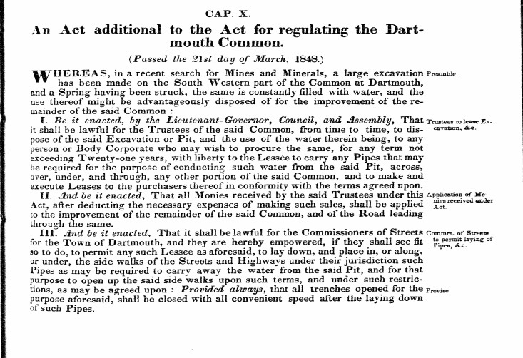
An Act additional to the Act for regulating the Dartmouth Common. (Passed the 21st day of March, 1848.)
Preamble: WHEREAS, in a recent search for Mines and Minerals, a large excavation has been made on the South Western part of the Common at Dartmouth, and a Spring having been struck, the same is constantly filled with water, and the use thereof might be advantageously disposed of for the improvement of the remainder of the said Common :
Trustees to Lease Excavation, &c.: I. Be it enacted, by the Lieutenant-Governor, Council, and Assembly, That it shall be lawful for the Trustees of the said Common, from time to time, to dispose of the said Excavation or Pit, and the use of the water therein being, to any person or Body Corporate who may wish to procure the same, for any term not exceeding Twenty-one years, with liberty to the Lessee to carry any Pipes that may be required for the purpose of conducting such water from the said Pit, across, over, under, and through, any other portion of the said Common, and to make and execute Leases to the purchasers thereof in conformity with the terms agreed upon.
Application of Monies received under Act: II. And be it enacted, That all Monies received by the said Trustees under this application of Mo Act, after deducting the necessary expenses of making such sales, shall be applied et to the improvement of the remainder of the said Common, and of the Road leading through the same.
Commrs. of Streets to permit laying of Pipes, &c., Proviso: III And be it enacted, That it shall be lawful for the Commissioners of Streets for the Town of Dartmouth, and they are hereby empowered, if they shall see fit so to do, to permit any such Lessee as aforesaid, to lay down, and place in, or along, or under, the side walks of the Streets and Highways under their jurisdiction such Pipes as may be required to carry away the water from the said Pit, and for that purpose to open up the said side walks upon such terms, and under such restrictions, as may be agreed upon : Provided always, that all trenches opened for the purpose aforesaid, shall be closed with all convenient speed after the laying down of such Pipes.
“Additional Act relating to the Dartmouth Common”, 1848 c10
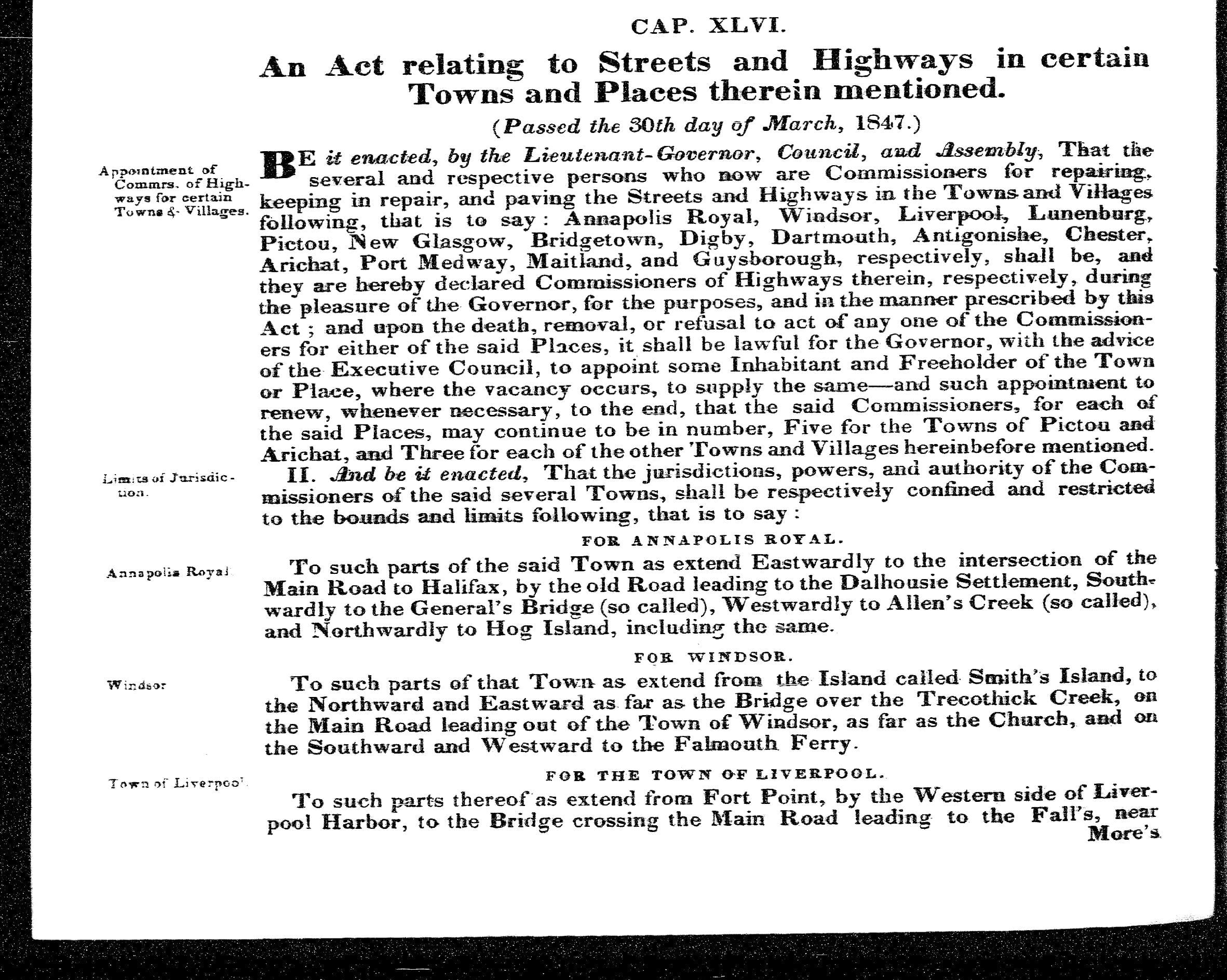
An Act relating to Streets and Highways in certain Towns and Places therein mentioned.
(Passed the 30th day of March, 1847.)
Appointment of Commrs. of High-ways for certain Towns & Villages:
BE it enacted, by the Lieutenant-Governor, Council, and Assembly, That the several and respective persons who now are Commissioners for repairing, keeping in repair, and paving the Streets and Highways in the Towns and Villages following, that is to say: Annapolis Royal, Windsor, Liverpool, Lunenburg, Pictou, New Glasgow, Bridgetown, Digby, Dartmouth, Antigonish, Chester, Arichat, Port Medway, Maitland, and Guysborough, respectively, shall be, and they are hereby declared Commissioners of Highways therein, respectively, during the pleasure of the Governor, for the purposes, and in the manner prescribed by this Act; and upon the death, removal, or refusal to act of any one of the Commissioners for either of the said Places, it shall be lawful for the Governor, with the advice of the Executive Council, to appoint some Inhabitant and Freeholder of the Town or Place, where the vacancy occurs, to supply the same–and such appointment to renew, whenever necessary, to the end, that the said Commissioners, for each of the said Places, may continue to be in number, Five for the Towns of Pictou and Arichat, and Three for each of the other Towns and Villages hereinbefore mentioned.
Limits of Jurisdiction:
II. And be it enacted, That the jurisdictions, powers, and authority of the Com
missioners of the said several Towns, shall be respectively confined and restricted to the bounds and limits following, that is to say:
….
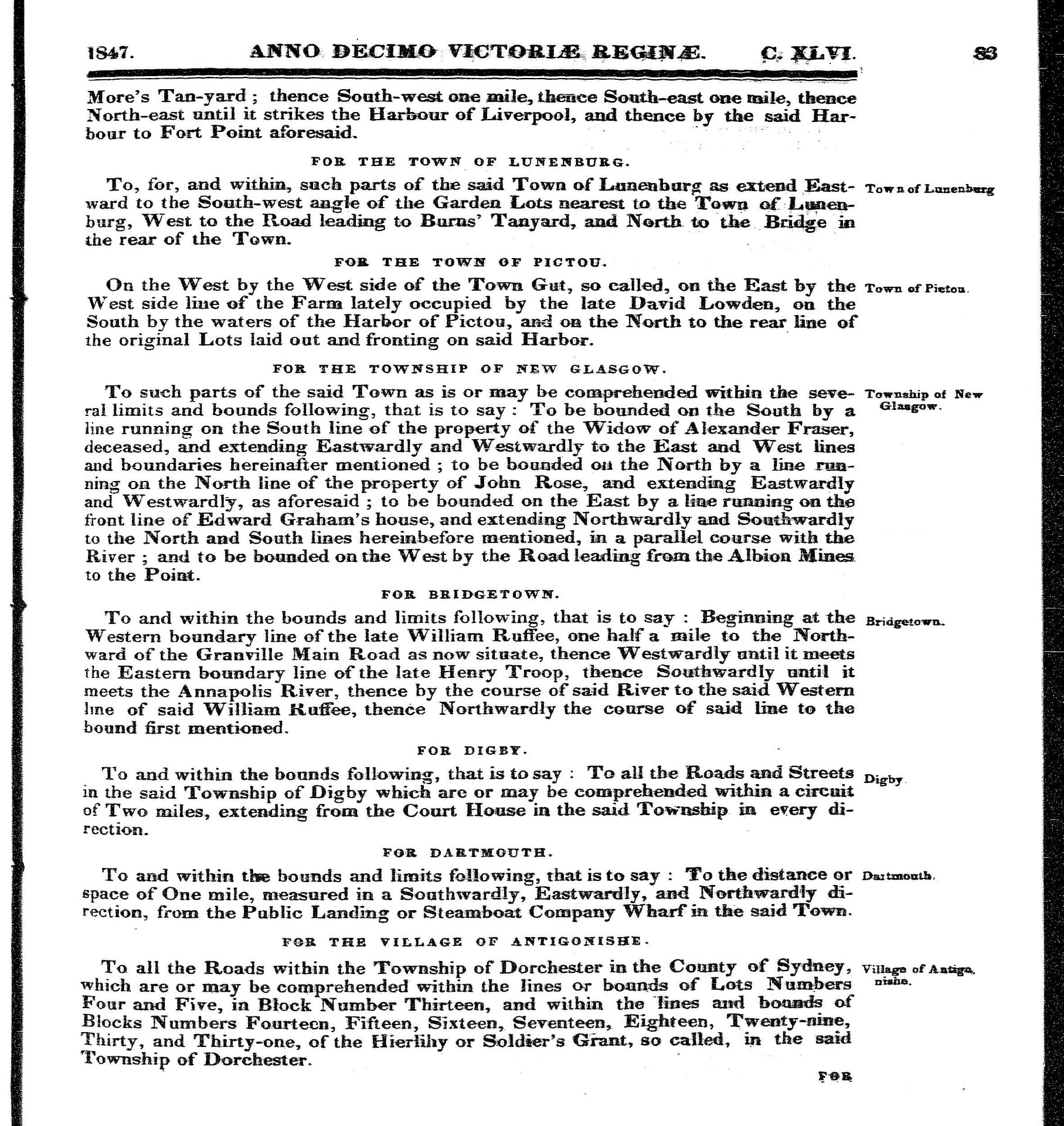
FOR DARTMOUTH:
Dartmouth:
To and within the bounds and limits following, that is to say: To the distance or space of One mile, measured in a Southwardly, Eastwardly, and Northwardly direction, from the Public Landing or Steamboat Company Wharf in the said Town.
….
“An act relating to Streets and Highways … in the Town of Dartmouth “, 1847 c46
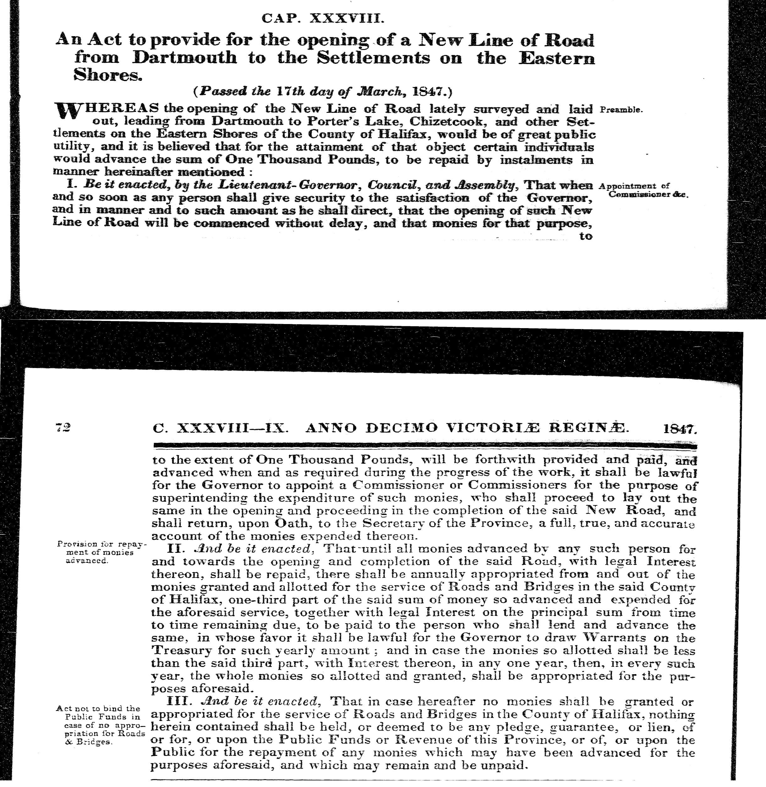
An Act to provide for the opening of a New Line of Road from Dartmouth to the Settlements on the Eastern Shores
(Passed the 17th day of March, 1847.)
Preamble:
WHEREAS the opening of the New Line of Road lately surveyed and laid out, leading from Dartmouth to Porter’s Lake, Chezzetcook, and other Settlements on the Eastern Shores of the County of Halifax, would be of great public utility, and it is believed that for the attainment of that object certain individuals would advance the sum of One Thousand Pounds, to be repaid by instalments in manner hereinafter mentioned:
Appointment of Commissioner &c.
I. Be it enacted, by the Lieutenant-Governor, Council, and Assembly, That when and so soon as any person shall give security to the satisfaction of the Governor, and in manner and to such amount as he shall direct, that the opening of such New Line of Road will be commenced without delay, and that monies for that purpose, to the extent of One Thousand Pounds, will be forthwith provided and paid, and advanced when and as required during the progress of the work, it shall be lawful for the Governor to appoint a Commissioner or Commissioners for the purpose of superintending the expenditure of such monies, who shall proceed to lay out the same in the opening and proceeding in the completion of the said New Road, and shall return, upon Oath, to the Secretary of the Province, a full, true, and accurate account of the monies expended thereon.
Provision for repayment of monies advanced:
II. And be it enacted, That-until all monies advanced by any such person for and towards the opening and completion of the said Road, with legal Interest thereon, shall be repaid, there shall be annually appropriated from and out of the monies granted and allotted for the service of Roads and Bridges in the said County of Halifax, one-third part of the said sum of money so advanced and expended for the aforesaid service, together with legal Interest on the principal sum from time to time remaining due, to be paid to the person who shall lend and advance the same, in whose favor it shall be lawful for the Governor to draw Warrants on the Treasury for such yearly amount ; and in case the monies so allotted shall be less than the said third part, with Interest thereon, in any one year, then, in erery such year, the whole monies so allotted and granted, shall be appropriated for the purposes aforesaid.
Act not to bind the Public Funds in case of no appropriation for Roads & Bridges:
III. And be it enacted, That in case hereafter no monies shall be granted or appropriated for the service of Roads and Bridges in the County of Halifax, nothing herein contained shall be held, or deemed to be any pledge, guarantee, or lien, of or for, or upon the Public Funds or Revenue of this Province, or of, or upon the Public for the repayment of any monies which may have been advanced for the purposes aforesaid, and which may remain and be unpaid.
“To provide for the opening of a new Road from Dartmouth to Eastern Shores”, 1847 c38
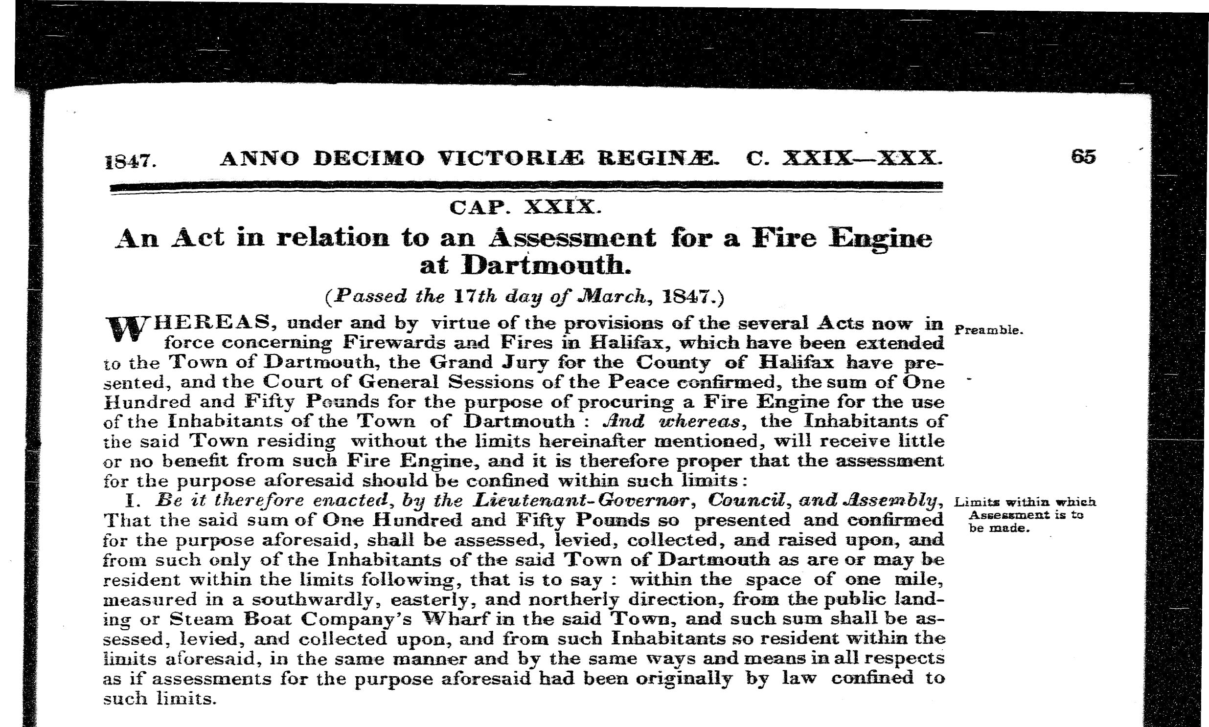
An Act in relation to an Assessment for a Fire Engine at Dartmouth. (Passed the 17th day of March, 1847.)
Preamble: WHEREAS, under and by virtue of the provisions of the several Acts now in force concerning Firewards and Fires in Halifax, which have been extended to the Town of Dartmouth, the Grand Jury for the County of Halifax have presented, and the Court of General Sessions of the Peace confirmed, the sum of One Hundred and Fifty Pounds for the purpose of procuring a Fire Engine for the use of the Inhabitants of the Town of Dartmouth And whereas, the Inhabitants of the said Town residing without the limits hereinafter mentioned, will receive little or no benefit from such Fire Engine, and it is therefore proper that the assessment for the purpose aforesaid should be confined within such limits:
Limits within which Assessment is to be made: I. Be it therefore enacted, by the Lieutenant-Governor, Council, and Assembly, That the said sum of One Hundred and Fifty Pounds so presented and confirmed for the purpose aforesaid, shall be assessed, levied, collected, and raised upon, and from such only of the Inhabitants of the said Town of Dartmouth as are or may be resident within the limits following, that is to say : within the space of one mile, measured in a southwardly, easterly, and northerly direction, from the public landing or Steam Boat Company’s Wharf in the said Town, and such sum shall be assessed, levied, and collected upon, and from such Inhabitants so resident within the limits aforesaid, in the same manner and by the same ways and means in all respects as if assessments for the purpose aforesaid had been originally by law confined to such limits.
“In relation to Assessment for a Fire Engine at Dartmouth”, 1847 c29