Topographic Map Nova Scotia – Uniacke Sheet and Chezzetcook Sheet No. 11

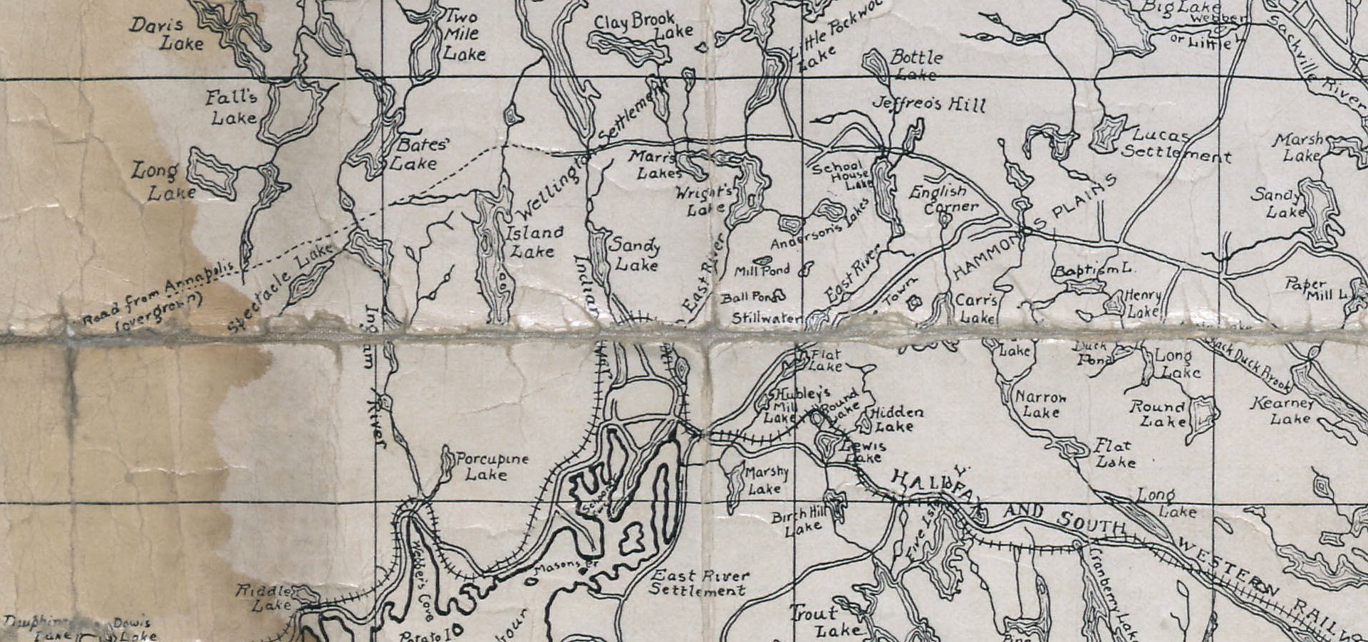
Lots of detail in this topographical map surveyed in 1920 and reprinted in 1946.

The path of the “Old Annapolis Road” can still be seen.

“Topographic Map Nova Scotia – Uniacke Sheet and Chezzetcook Sheet No. 11. Surveyed and Reproduced by the Geographical Section, General Staff, Department of National Defence. Surveyed 1920 reprinted 1946”, https://archives.novascotia.ca/african-heritage/archives/?ID=682

A new and accurate map of the English empire in North America

nova scotia map
nova scotia map
nova scotia map

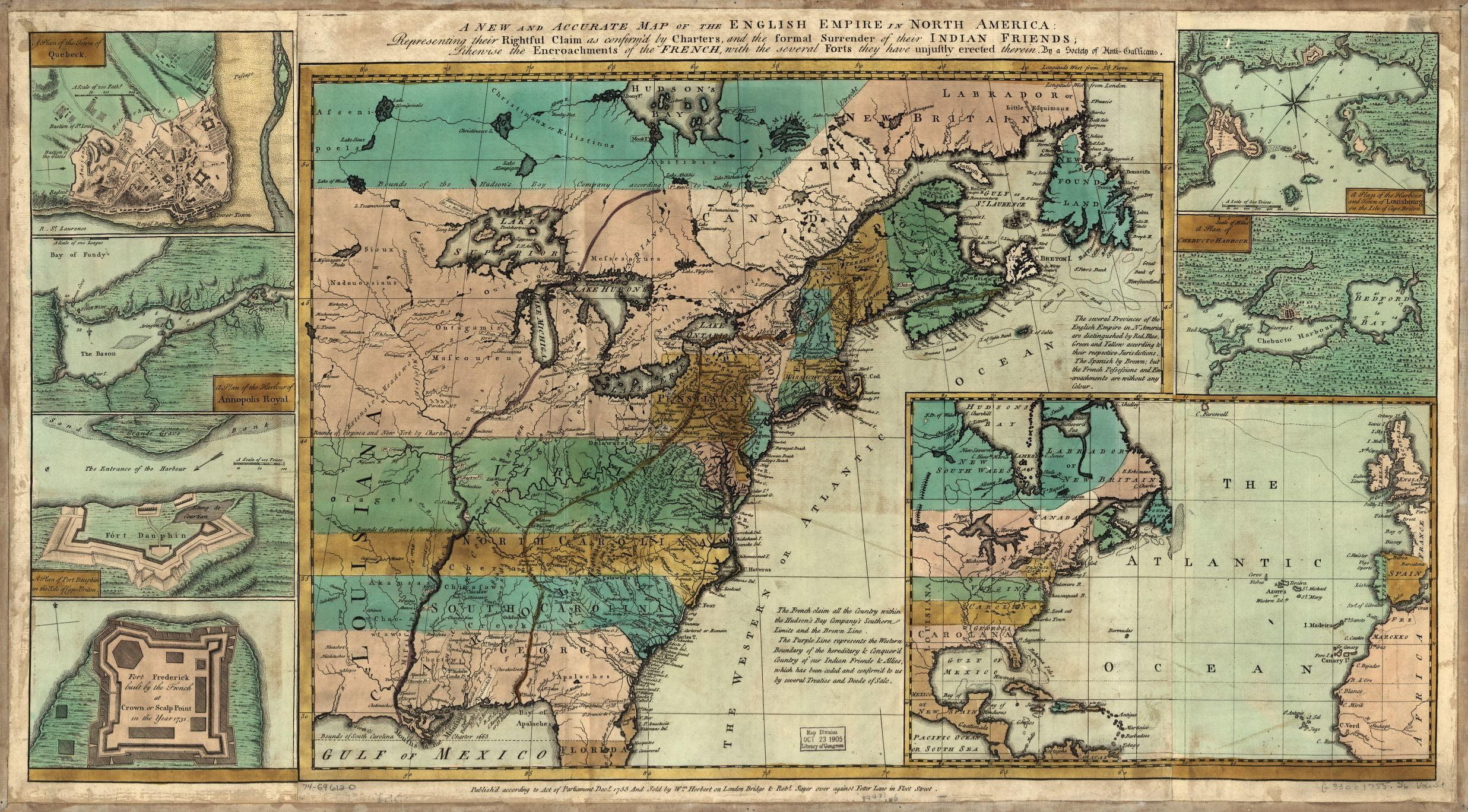
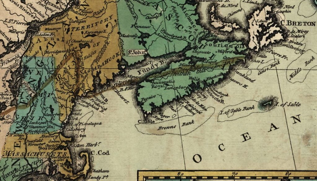
“The French claim all the country within the Hudson’s Bay Company’s southern limits and the brown line”, an entity just recently privatized.

Perhaps this border shown here as the 45° latitude explains the location of the Old Annapolis Road which it seems to straddle somewhat, beyond the fact that it connected Nova Scotia’s old capital of Annapolis to the new capital of Halifax. Perhaps it explains much more, considering the placement of Greenwood (CFB), Halifax Airport (YHZ) and Windsor, all just below 45°.

It would be amazing to be able to preserve the Old Annapolis Road ROW as much as possible for future generations, perhaps some kind of restoration as a hiking trail especially the parts that lie hidden before it’s completely lost to the woods.

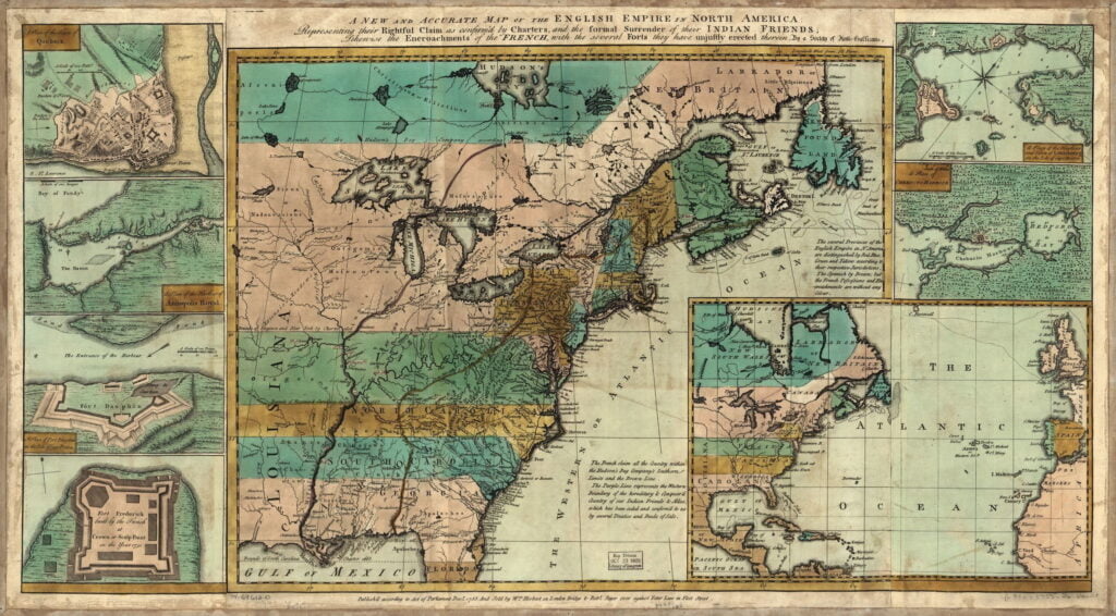
“A new and accurate map of the English empire in North America; Representing their rightful claim as confirmed by charters and the formal surrender of their Indian friends; likewise the encroachments of the French, with the several Society Of Anti-Gallicans, William Herbert, and Robert Sayer. London, Sold by Wm. Herbert, 1755. Map. Retrieved from the Library of Congress, <www.loc.gov/item/74696120/>.

Old Annapolis Road

old-annapolis-road2

After piecing together several Crown land grant maps, you can see the path of the Old Annapolis Road much more clearly. Open the image in a new tab, to see it in more detail.

Below you’ll find a few representations of the road as a contiguous route, as opposed to what is left recorded on the Crown Land Grant maps. (You can find find the individual Crown Land Grant maps here: https://novascotia.ca/natr/land/grantmap.asp)

One of the earliest road maps, from 1755, the Bay of Fundy still going by the name of Argal’s Bay. “A New map of Nova Scotia and Cape Britain”, https://gallica.bnf.fr/ark:/12148/btv1b53089581f

“Map of Nova Scotia, or Acadia, with the islands of Cape Breton and St. John’s, from actual surveys” https://gallica.bnf.fr/ark:/12148/btv1b53209890m

Previous to the construction of the more direct route to Annapolis, this map from 1776 shows a road (from Dartmouth, certainly an error, likely from Fort Sackville at the head of the harbor) to Annapolis. “A general Map of the northern British Colonies in America which comprehends the province of Quebec, the government of Newfoundland, Nova Scotia, New England and New-York” https://gallica.bnf.fr/ark:/12148/btv1b8443126p

One of the first representations of the Old Annapolis Road, “Road markt out by Gov. Parr’s orders in 1784”

nova scotia map Annapolis road

“A map of Nova Scotia showing the post roads”, 1787. https://collections.leventhalmap.org/search/commonwealth:hx11z4938

“A Map of the United States and Canada, New Scotland, New Brunswick and New Foundland”, 1806. https://gallica.bnf.fr/ark:/12148/btv1b53100560v

“Map of the Province of Nova Scotia Including Cape Breton, Prince Edwards Island and Part of New Brunswick”, 1819. https://nscc.cairnrepo.org/islandora/object/nscc%3A112, https://collections.leventhalmap.org/search/commonwealth:8049g892q

“Map of the Provinces Of New Brunswick, and Nova Scotia”, 1825. https://nscc.cairnrepo.org/islandora/object/nscc%3A715

annapolis road map 1827

“Map of the United States; and the Provinces of Upper & Lower Canada, New Brunswick, and Nova Scotia”, 1827: https://www.davidrumsey.com/luna/servlet/detail/RUMSEY~8~1~4239~340032:Map-of-the-United-States-

“The Provinces of Lower & Upper Canada, Nova Scotia, New Brunswick, Newfoundland & Prince Edward Island with a large section of the United States”, 1831. https://gallica.bnf.fr/ark:/12148/btv1b530987207

“Maps of the Society for the Diffusion of Useful Knowledge”, 1832: https://www.davidrumsey.com/luna/servlet/detail/RUMSEY~8~1~20966~530058:Nova-Scotia,-N-B-,-Lower-Canada

“North America : sheet I. Nova-Scotia with part of New Brunswick and Lower Canada”, 1832: https://digitalarchive.mcmaster.ca/islandora/object/macrepo%3A26988

“Nouvelle carte des Etats-Unis, du Haut et Bas-Canada : de la Nouv[el]le-Écosse, du Nouv[e]au-Brunswick, de Terre-Neuve”, 1832
https://gallica.bnf.fr/ark:/12148/btv1b530354369

“Map of the United States; and the Provinces of Upper & Lower Canada, New Brunswick, and Nova Scotia”, 1835: https://www.davidrumsey.com/luna/servlet/detail/RUMSEY~8~1~316476~90085094:Composite–Map-of-the-United-States

From: “The London atlas of universal geography”, 1837: https://www.davidrumsey.com/luna/servlet/detail/RUMSEY~8~1~33890~1170042:Lower-Canada

From: “British Possessions in North America, with part of the United States”, 1840: https://hdl.huntington.org/digital/collection/p15150coll4/id/9901

From: “Nelson’s new map of the British provinces in North America”, 1840–1849: https://collections.leventhalmap.org/search/commonwealth:0z709278h

From: “Lower Canada, New Brunswick, Nova Scotia, Prince Edwards Id. Newfoundland, and a large portion of the United States”, 1846. https://digitalarchive.mcmaster.ca/islandora/object/macrepo%3A31427

“Map of the provinces of Canada, New Brunswick, Nova Scotia, Newfoundland and Prince Edward Island”, 1846. https://digitalarchive.mcmaster.ca/islandora/object/macrepo%3A81413

“Lower Canada, New Brunswick, Nova Scotia, Prince Edwards Id. Newfoundland, and a large portion of the United States.”, 1853. https://hdl.huntington.org/digital/collection/p15150coll4/id/100

“Belcher’s map of the Province of Nova Scotia”, 1855: https://www.davidrumsey.com/luna/servlet/detail/RUMSEY~8~1~3016~290077:Belcher-s-map-of-the-Province-of-

“Map of the British Province of New Brunswick”, 1858: https://www.davidrumsey.com/luna/servlet/detail/RUMSEY~8~1~325278~90094243:Map-of-the-British-Province-of-New-

“The royal atlas of modern geography”, 1861: https://www.davidrumsey.com/luna/servlet/workspace/handleMediaPlayer?qvq=&trs=&mi=&lunaMediaId=RUMSEY~8~1~21338~620038

“Mackinlay’s map of the Province of Nova Scotia, including the island of Cape Breton”, 1862: https://www.davidrumsey.com/luna/servlet/detail/RUMSEY~8~1~2372~220044:Mackinlay-s-map-of-the-Province-of-

The portion of the Annapolis road that traverses Halifax County, as seen in the “Topographical township map of Halifax County” from A.F. Church and Co, 1864. https://collections.lib.uwm.edu/digital/collection/agdm/id/14722/rec/1

“Mackinlay’s map of the Province of Nova Scotia”, 1865: https://www.davidrumsey.com/luna/servlet/detail/RUMSEY~8~1~2374~220046:Mackinlay-s-map-of-the-Province-of-

“Colton’s… Nova Scotia”, 1865: https://www.davidrumsey.com/luna/servlet/detail/RUMSEY~8~1~208606~5003402:New-Brunswick,-Nova-Scotia–Prince-

“Colton’s Dominion of Canada”, 1869: https://www.davidrumsey.com/luna/servlet/detail/RUMSEY~8~1~208947~5003938:Dominion-of-Canada–Provinces-of-Ne

Annapolis Road seen here at Stoddards as it made its way through to what is now Dalhousie East. “Annapolis County part of A.F. Church Map”, 1876. https://archives.novascotia.ca/maps/archives/?ID=942

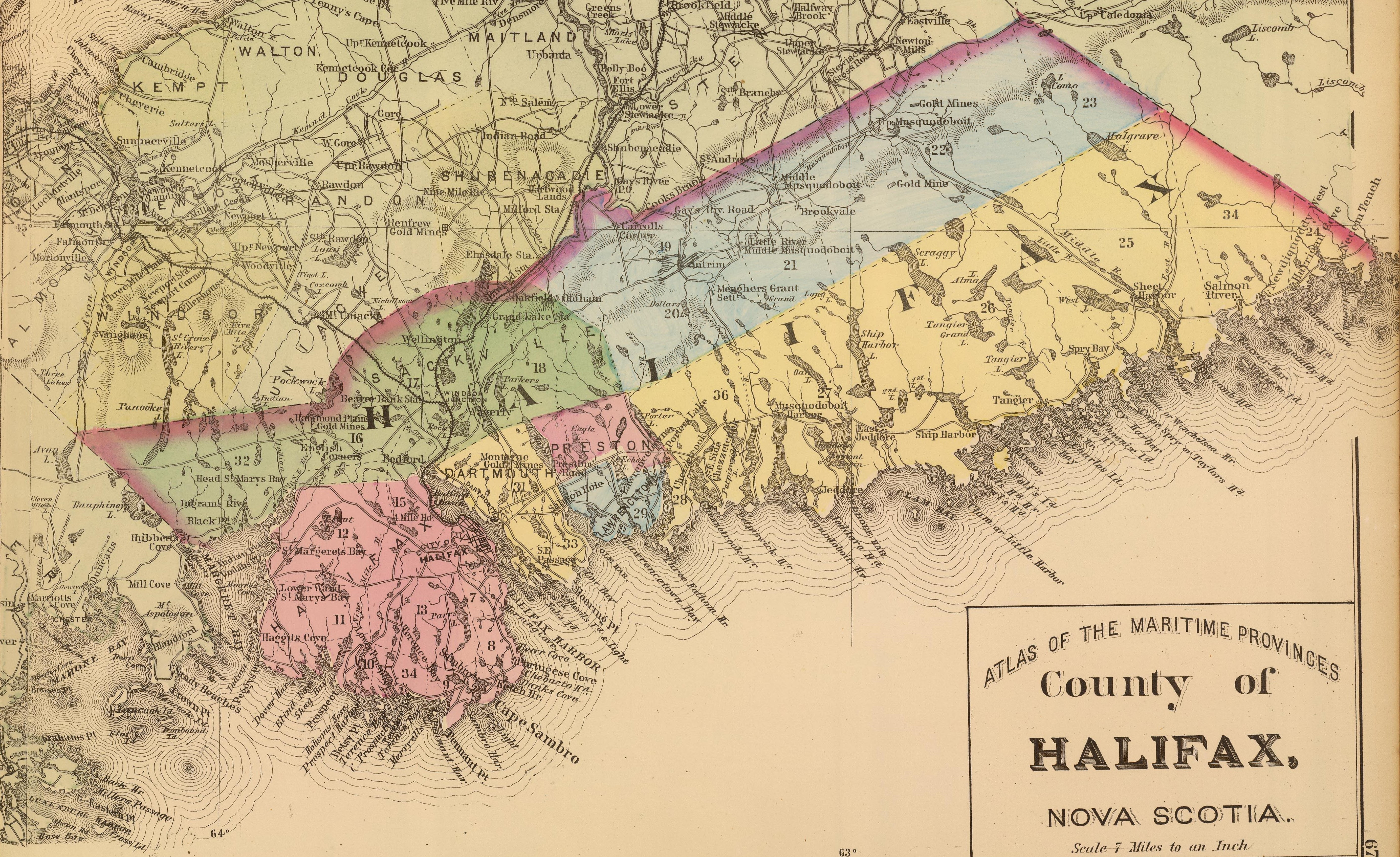
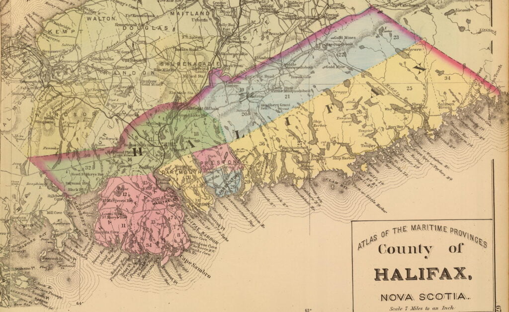
Annapolis Road pieced together from several pages of the “Atlas of the Maritime Provinces of the Dominion of Canada”, Roe Brothers, St. John, NB 1878. https://www.islandimagined.ca/roe_atlas

“Statistical & general map of Canada”, 1883: https://www.davidrumsey.com/luna/servlet/detail/RUMSEY~8~1~31463~1150419:Canada-1-

“Canada : the provinces of Quebec, Nova Scotia, New Brunswick, Prince Edward Island and Newfoundland”, 1886. https://digitalarchive.mcmaster.ca/islandora/object/macrepo%3A27057

“Mackinlay’s map of the Province of Nova Scotia”, 1890: https://www.davidrumsey.com/luna/servlet/detail/RUMSEY~8~1~3012~220131:Mackinlay-s-map-of-the-Province-of-

“Stanford’s London atlas of universal geography”, 1904: https://www.davidrumsey.com/luna/servlet/detail/RUMSEY~8~1~314730~90083550:Quebec,-New-Brunswick,-Nova-Scotia

“Dominion of Canada : E. Quebec, New Brunswick, Nova Scotia, Prince Edward Id. and Newfoundland”, 1910. https://collections.library.yale.edu/catalog/15827305

One of the last representations of the Old Annapolis Road:

Mackinlay’s map of the Province of Nova Scotia Compiled from Actual & Recent Surveys, 1912: https://nscc.cairnrepo.org/islandora/object/nscc%3A534

Fifteen years later, by 1927, the Old Annapolis Road disappears from the maps. Perhaps it wasn’t fit for automobile travel, though it’s hard not to notice the change (back?) to “Annapolis Royal” from “Annapolis” occurred at the same time.

From: “Rand McNally auto road atlas of the United States and Ontario, Quebec, and the Maritime Provinces of Canada”, 1927: https://www.davidrumsey.com/luna/servlet/detail/RUMSEY~8~1~33775~1171491:Maritime-Provinces-

Much of the road is now incorporated into other routes. It’s the #8 from Annapolis through Lequille, it’s the West Dalhousie Road through to Lake La Rose and from West Dalhousie to Albany Cross on to Stoddard’s where it once continued straight at what is now a turn (see above at 1876). It then crossed over the brook that empties into Upper Thirty Lake, from there it continued across another bridge, this time over the LaHave River to connect to what is now Camel Hill Road. The route proceeded to where it now meets Cherryfield Road and becomes Dalhousie Road, and on eastwards from there, through to Franey Corner and on to New Ross. At this point the route seems to have been reclaimed by the woods somewhat but it continued south and east near Sherwood, and then north of Canaan and Timber Lake, to the south of Panuke Lake (once called “Carrying Place”, see above at 1864) near Simms Settlement, through the country between Sandy and Rafter lake then terminating at Pockwock Road, north of Wrights Lake in Upper Hammonds Plains.

From: “Halifax & Dartmouth City & Maritimes map”, 1976. https://archives.novascotia.ca/maps/archives/?ID=948&Page=202012493

See also: