1493 – May 4, Alexander VI, Pope of Rome, issued a bull, granting the New World. Spain laid claim to the entire North American Coast from Cape Florida to Cape Breton, as part of its territory of Bacalaos.
1502 – Henry VII commissioned Hugh Eliot and Thomas Ashurst to discover and take possession of the islands and continents in America; “and in his name and for his use, as his vassals, to enter upon, doss, conquer, govern, and hold any Mainland or Islands by them discovered.”
1524 – Francis I, King of France, said that he should like to see the clause in Adam’s will, which made the American continent the exclusive possession of his brothers of Spain and Portugal, is said to have sent out Verrazzano, a Florentine corsair, who, as has generally been believed, explored the entire coast from 30° to 50° North Latitude, and named the whole region New France.
1534 – King Francis commissioned Jacques Cartier to discover and take possession of Canada; “his successive voyages, within the six years following, opened the whole region of St. Lawrence and laid the foundation of French dominion on this continent.”
1584 – March 25, Queen Elizabeth renewed Gilbert’s grant to Sir Walter Raleigh, his half-brother. Under this commission, Raleigh made an unsuccessful attempt to plant an English colony in Virginia, a name afterwards extended to the whole North Coast of America in honor of the “Virgin” Queen.
1603 – November 8, Henry IV, King of France, granted Sieur de Monts a royal patent conferring the possession of and sovereignty of the country between latitudes 40° and 46° (from Philadelphia as far north as Katahdin and Montreal). Samuel Champlain, geographer to the King, accompanied De Monts on his voyage, landing at the site of Liverpool, N.S., a region already known as “Acadia.”
1620 – November 3, Reorganization of the Plymouth Company in 1620 as the Council of Plymouth for New England, encompassing from 40° to 48° North latitude.
1630 – April 30, Conveyance of Nova-Scotia (Port-royal excepted) by Sir William Alexander to Sir Claude St. Etienne Lord of la Tour and of Uarre and to his son Sir Charles de St. Etienne Lord of St. Denniscourt, on condition that they continue subjects to the king of Scotland under the great seal of Scotland.
1632 – March 29, Treaty of Saint-Germain-en-Laye, between King Louis XIII. and Charles King of England for the restitution of the New France, Cadia and Canada and ships and goods taken from both sides.
1758 – Nova Scotia Legislature established (consisting of the Lieutenant Governor, his Council and the newly established, elected legislative assembly called the House of Assembly)
1760 – March, Treaty of Peace and Friendship concluded by the Governor of Nova Scotia with Paul Laurent, Chief of the La Heve tribe of Indians
1763 – February 10, France ceded, for the last time, the rest of Acadia, including Cape Breton Island (‘île Royale), the future New Brunswick and St John’s Island (later re-named Prince Edward Island), to the British (Treaty of Paris) and it was joined to Nova Scotia
1784 – Cape Breton Island and New Brunswick established as colonies separate from Nova Scotia
1820 – Cape Breton Island re-joined to Nova Scotia
1838 – Separate Executive Council and Legislative Council established
1848 – Responsible government established in Nova Scotia (Members of the legislature had the ability to elect a majority of those in the Legislative council)
1867 – “Union” of provinces of Canada, New Brunswick and Nova Scotia as the “self-governing” federal colony of the Dominion of Canada (British North America Act, 1867 — now known in Canada as Constitution Act, 1867) & the Parliament of Canada established (consisting of the Queen, the Senate and the House of Commons)
1928 – Abolition of the Legislative Council (leaving the Legislature consisting of the Lieutenant Governor and the House of Assembly)
Harvard Law School Library. “Description Legislative history regarding treaties of commerce with France, Spain relating to New Foundland, Nova Scotia, and Cape Breton,” ca. 1715? Small Manuscript Collection, Harvard Law School Library. https://nrs.harvard.edu/urn-3:HLS.LIBR:19686447, Accessed 07 June 2021
Thorpe, Francis Newton. “The Federal and State constitutions: colonial charters, and other organic laws of the States, territories, and Colonies, now or heretofore forming the United States of America” Washington : Govt. Print. Off. 1909. https://archive.org/details/federalstatecons07thor/page/n5/mode/2up
Marshall, John G. “The justice of the peace, and county and township officer in the province of Nova Scotia : being a guide to such justice and officers in the discharge of their official duties” [Halifax, N.S.? : s.n.], 1837 (Halifax [N.S.] : Gossip & Coade) https://www.canadiana.ca/view/oocihm.36869, Second Edition: https://www.canadiana.ca/view/oocihm.38224
Laing, David, editor. “Royal letters, charters, and tracts, relating to the colonization of New Scotland, and the institution of the Order of knight baronets of Nova Scotia. -1638“. [Edinburgh Printed by G. Robb, 1867] https://archive.org/details/royallettersc11400lainuoft
“Since the late 1950s there has been an explosion of residential development within the commuter belt of Halifax, Nova Scotia. This city region is unusual in having very little farming or pre-existing settlement, so that land prices are low, and development controls have been minimal. Conversely, however, the predominantly hardrock environment presents severe difficulties for the extension of sewer and water lines, and has thus constrained the growth of serviced residential subdivisions. This paper documents the regional progression of both suburban residential development, which is generally serviced, and exurban or country residential development (CRD), which is generally unserviced.
The author’s aims are, first, to describe the locational sequence of peri-urban residential development in the Halifax city region over the 40-year period 1960-2000. Secondly, to analyze and explain that sequence in terms of three sets of factors: magnets or attractors for residential development, constraints or inhibitors, and planning policies designed to control or direct development. Thirdly, to identify lessons from the past which suggest useful policy options for planning of future residential patterns. An assessment of past development processes and current options is particularly timely, since the region’s four municipal units (the cities of Halifax and Dartmouth, the town of Bedford, and the Municipality of the County of Halifax) amalgamated in 1996 to form the Halifax Regional Municipality (HRM–see Millward 1996, 12-14). This regional government now stands ready to prepare a new land-use and transportation plan for the region.
While Halifax’s special environmental circumstances have produced a pattern of development which is unique in its particulars, many of the driving factors operative in the Halifax region are also actively or potentially operative throughout the developed world. The lessons from a detailed case study should therefore have considerable transferability, particularly to other city regions possessing high personal mobility in combination with low rural land valuations. Halifax allows an exceptionally clear view of the dramatic effects of automobile-induced commuter development, since its hinterland was remarkably devoid of resource-based settlement prior to 1950, there are no alternative urban employment centres within commuting range, rural land prices are extremely low, and competition or conflict between housing and resource industries has been minimal. The combined effect of these conditions is that pre-1960 housing within the commuter-shed has been swamped by post-1960 development, both in suburban and exurban areas. The paper also has wider relevance in that it highlights the local importance of broad shifts in styles of governance and planning philosophies. These shifts occurred worldwide after 1980, and the Halifax case illustrates the impact of policy and funding changes on the promotion and control of peri-urban residential development.
The Regional Situation to 1960 Halifax was founded as a fortress and naval base, not as the central place for a region of agricultural settlement (Millward 1993). Indeed, the physical environment almost precludes farming, being a forbidding land of glacially-scoured igneous and metamorphic rocks (granite, slate, and greywacke), poorly-drained, strewn with boulders, and lacking topsoil. Within the area depicted on Figure 1, only a few areas had sufficient depth to bedrock to enable settlement for semi-subsistence farming (Canada Land Inventory classes 3 to 5): these are the softrock environments to the north and a discontinuous area of drumlinized glacial till extending from Halifax east to Chezzetcook. Glacial till also enabled small pockets of farming in the Sackville river valley at Hammonds Plains, and on the north-east margins of St. Margaret’s Bay. Elsewhere the interior remained virtually unsettled through to 1960, with the exception of several Black communities–North Preston and Beechville (near Lakeside)–which began life as subsistence farming communities despite their lack of topsoil (see Henry 1973; Pachai 1987/1990).”
Great period map showing the different communities in the general vicinity — Woodside, Woodlawn, Port Wallace, Tufts Cove.
“The Royal Bank was founded in Halifax in 1869 by seven prominent Halifax merchants” isn’t the kind of thing you’d hear from “RBC” these days, that’s for sure, among other things.
Today DARTMOUTH is Canada’s newest city – a community which is noted for its vision and aggressiveness – a sparkplug for Nova Scotia’s resurgence in this decade.
Now wearing its newly won city status like a queen – DARTMOUTH reigns over a population of more than 45,000 – a figure which is growing by the minute.
Covering an area of 15,000 acres, the mushrooming DARTMOUTH is the largest city from a physical point of view anywhere in the Maritimes.
Its inland waters, many of which are protected by public ownership for the enjoyment of future generations, are a source of undying pride and have become Dartmouth’s trademark across Canada.
Accommodations
Our local Tourist Bureau is capable of providing you with detailed information on tourist accommodations in the metropolitan Dartmouth area. Facilities to suit all pocketbooks are available, ranging from the two newly opened motels at Graham’s Corner to our mid-city Belmont Hotel. For the homier atmosphere, the facilities of Hawthorne House, near the lakes, is the answer.
Shopping areas
Two fine shopping areas, providing an inviting place for Dartmouth visitors to seek out unusual gifts and souvenirs, or another aspect of Canada’s newest city which should not be overlooked. Both the downtown business area and the bustling Dartmouth shopping center have a very fine variety of stores, and between the two can satisfy the most discriminating shoppers.
Fishing and hunting
The Eastern shores of Nova Scotia have long been noted for their excellent fishing and hunting areas. For saltwater fishing in the immediate area of Dartmouth, we find Rich catches of pollock and mackerel, while other varieties quite often hooked include haddock, hake, halibut and cod. Deep sea fishing tours for tuna are also available by appointment in the Dartmouth area. More information may be obtained from the local tourist bureau. As for freshwater fishing, we find that the Atlantic salmon, speckled and Brook trout, particularly in the Musquodobit river, which is only about 25 miles from the city limits. Fishing streams extend along the entire East Coast line. The sporty sebago salmon may be fished out of Shubenacadie, Grand Lake – a few miles north of our city. Principal game hunted in Open season within reasonable driving range of Dartmouth – include whitetail or Virginia deer, hair or snowshoe rabbit, black bear, wild or bobcat, red fox and raccoon.
Recreational highlights
There are five supervised public beaches within the city – one at Birch Cove on Lake Banook, and another at the foot of Lake Banook between our two canoe clubs, the Banook and Micmac A.A.C. On Lake Micmac, the 2nd of Dartmouth’s famous chain of lakes – there is sunrise Beach at the Port Wallace walks part of the old Shubenacadie canal, referred to in the history of Dartmouth. On Maynard’s lake, at the top of Portland street, we have the Kinsman Playgrounds, and a public supervised swimming area. In addition to the freshwater swimming areas, lovely silver sands on the Atlantic is but a 20 mile drive from downtown Dartmouth.
For aesthetic recreation, visitors will enjoy the flowers and view at the Dartmouth Civic Park, located directly behind City Hall, and the Tourist Bureau, or a visit to Sullivan’s Pond on Ochterloney Street and Prince Albert Road.
Natal Day
Dartmouth Natal Day, each year falling on the first Wednesday in August, marks the traditional climax to regatta competitions. If you are in the Province during this period, be sure to help us celebrate.
Churches
Represented among the various denominations in our City are Anglicans, Roman Catholics, Presbyterian, Baptist, United, Salvation Army, Mormon, as well as minority groups such as Nazarene, Christian Church, and Jehovah Witness.
Some of our major churches and their pastor or minister include: United (St. James) – Rev. W. Grant MacDonald Anglican (Christ Church) Dr. L.F. Hatfield Baptist (First Dartmouth) Rev. Earl Ward Catholic (St. Peter’s) Msgr. Gerald Murphy
In the narrows off here, occurred the disastrous harbor explosion of 1917, when a munition ship blew to pieces. Honorable Joseph Howeresidence at nearby armament Depot site (–between Jamieson and Dawson Streets on the harbor side of Windmill Road) 1863 to 1869
Scenic drives
Pleasant Street to Eastern Passage and Silver Sands – enjoy a pleasant drive along the eastern shore of Halifax harbor.
The Ocean Highway – enjoy miles of scenic driving along the cool, wide open Waters of the Atlantic Ocean from coal harbor to Chezzetcook, with fishing villages and miles of Sandy saltwater beaches.
Lake-lined Waverly road – in contrast to the saltwater type scenery, this route takes you along the shores of four beautiful, freshwater lakes on a highway lined with trees.
Our Tourist Bureau receptionists will give you additional information.
For Your Guidance
Following is a list of most of our service clubs and community organizations: Junior chamber of commerce, P.O. Box 71, Dartmouth. Ivan Greek, President Chamber of commerce (E.A. House) Lions Club (Elroy Moser) Kinsman Club (Ray Wambolt) Kiwanis Club (Gary Low) Dartmouth Y’s Men (Gerald Eisner) Rotary Club (Donald Robert) Gyro Club (A. McGinnis)
Private Clubs (Membership not restricted) Brightwood Golf and Country Club, Owls Club, Banook Canoe Club, Mic Mac Club.
This guide to places of interest in historic Dartmouth has been prepared for you by the Dartmouth Chamber of Commerce and the Junior Chamber of Commerce.
We hope you have enjoyed your visit to Dartmouth. If there are any features you particularly enjoyed, or criticisms you may have to offer us, we would welcome hearing from you. Please write to the Dartmouth Tourist Bureau, Dartmouth.
City of Dartmouth, date uncertain, late 1960s likely (The sod was turned at City Hall, seen at bottom right, in June 1966 and was officially opened in September 1967).
Boggs Street at far right, Canadian Tire on Alderney Drive where Admiralty Place is now. The Bus depot can be seen middle right near the bottom of Canal Street.
Canadian TireBoggs StBus Depot
Dartmouth Medical Center at five corners, the Post Office still in possession of its clock tower, and the old Hawthorn School can be seen in the trees upper middle-left/
Dartmouth Medical CenterPost Office (with clock tower)Old Hawthorn School
The local government history of Nova Scotia reflects a circuitous progression, from central control to increasing local autonomy and back again to centralized control. From its inception in 1605 with Port Royal, local governance was essentially an extension of central government, lacking elected councils or municipal institutions. Annapolis Royal saw early attempts at local government with the establishment of a civil council in 1720 and a general court in 1721. Halifax’s founding in 1749 marked a shift, with the establishment of Quarter Sessions, allowing for local governance with administrative and judicial functions. The system was influenced by both the Virginia and New England-style systems, with Quarter Sessions and an Inferior Court of Common Pleas.
New England settlers in Halifax demanded greater local self-government, leading to conflicts and eventual incorporation of Halifax in 1841 after a push by figures like Joseph Howe. Despite earlier attempts at incorporation, Halifax faced disallowance due to resistance from the Legislative Council. Meanwhile, outside Halifax, the Quarter Sessions system persisted until 1879 when county incorporation became compulsory, replacing the old system with elected municipal councils. Towns also sought incorporation, Dartmouth being the first in 1873, with eight towns incorporated by 1888.
Towns had to meet population and area requirements for incorporation, with mayors and councillors elected for two-year terms. The councils had broad powers, including taxation and infrastructure development. By 1954, Nova Scotia comprised 18 counties, 24 rural municipalities, 39 incorporated towns, and 2 cities, each with its own local government structure, independent of county or district authority. By 1961 Dartmouth became the third incorporated city.
Functions of local government expanded over time, responding to social and economic changes. Traditional roles included regulation and service provision, such as supporting the poor, maintaining roads, and education. However, more modern demands led to the development of new services like community planning, housing, and recreation.
Financially, municipalities initially relied on property taxes but faced challenges due to increased demands and inflation. Provincial assistance, through grants and shared responsibilities, became essential, especially during times of war and economic downturns. Tax rental agreements and conditional grants help fund services like education and social assistance, reflecting a shift towards greater Provincial and Federal involvement.
Since the 1996 amalgamation, which unilaterally consolidated several local entities into one unit, local government in Nova Scotia has undergone significant restructuring. The dissolution of distinct municipalities has reshaped the landscape, upending established institutions, the concept of local government itself and the constitutional frameworks upon which it relied.
Background: Although there were no parliamentary institutions of any kind in the area during the French regime, local government of one sort or another has existed in Nova Scotia from the founding of Port Royal in 1605. It began not with elected municipal councils, nor with incorporated towns and cities, not even with the Court of Sessions or the Quarter Sessions. In its beginning it was essentially an extension of the arm of the central government.
…central administration at Annapolis Royal was modified and a measure of local government was provided. At Annapolis Royal a civil council was established in 1720 and a general court in 1721. The Acadians continued to choose their own deputies annually; Acadians acted as collectors of quit rents, notaries, herdsmen and overseers; and one Acadian (notwithstanding the difficulty over oaths of office) was commissioned justice of the peace in 1727. At Canso from 1720 there were justices of the peace, who were also usually captains of the militia there. Moreover, during his visits to Canso, Lieutenant-Governor Armstrong gave at least a semblance of local government to the place, by consulting the justices of the peace and a committee of the people there. “the least appearance of a Civil Government:’ he wrote, “being much more agreeable to Inhabitants than that of a Martial.”
Quarter Sessions: With the founding of Halifax by more than 2500 people from the Old Country in 1749, the seat of government was transferred to it from Annapolis Royal, and soon a system of local government by Quarter Sessions was established in the new capital. This system had been in operation in England for a long time; it was now transplanted in Nova Scotia. The Court of Quarter Sessions, composed of Justices of the Peace appointed by the Governor and Council, enabled the central government to extend its influence into local affairs. The Quarter Sessions had administrative as well as judicial functions; these included the appointment of local officers; licensing of taverns; control over weights and measures; fixing of certain prices; levying of poor and county rates; and control over roads and bridges, prisons and hospitals, and other public works.
The first Justices of the Peace for the Township of Halifax were commissioned on July 18, 1749. In December of the same year justices of the County Court were appointed, and a commission of the peace for the appointment of justices of the town and county of Halifax was issued. The justices of the County Court took their oath of office on December 27, 1749. and the County Court met for the first time on January 2, 1750. Although the first records of the Quarter Sessions are not now available (few being extant prior to 1766), it is likely that the Quarter Sessions first met on the same day as the County Court. Thus it seems quite clear that the Quarter Sessions were established at Halifax early in 1750. A year later the people were given a direct voice in choosing certain minor town officers. On January 14, 1751 the Governor and Council ordered that the town and suburbs of Halifax were to be divided into eight wards, and that the inhabitants were to be empowered annually to choose eight town overseers, one town clerk, sixteen constables and eight scavengers, for managing such prudential affairs of the town as should be committed to their care by the Governor and Council. For several years the annual election of constables was the only part of local government in which the people directly participated, and this was afterwards taken over by the Quarter Sessions.
If settlers from Old England founded Halifax, people from New England soon constituted the most important element in the new town. They quickly arrived in considerable numbers, in order to take advantage of the opportunities in trade or of the privileges accorded to settlers. Jealousy soon arose between the New World and the Old World settlers. with those from New England insisting upon a greater measure of local self-government and upon the adoption of practices to which they had previously been accustomed. At the outset the government had been modelled after that of Virginia, and accordingly, a County Court, meeting monthly, had been established. By March 2, 1752, however, a change was made in line with New England practice. The County Court became an Inferior Court of Common Pleas, meeting not monthly, but quarterly, on the first Tuesday in March, the first Tuesday in June, the first Tuesday in September, and the first Tuesday in December. As the justices of the Inferior Court of Common Pleas were also Justices of the Peace, the Quarter Sessions opened the same day as the Inferior Court, and the same Jurymen attended both courts.
For a few years, until a House of Assembly was established in 1758, the Governor and the Council of Twelve at Halifax enjoyed a monopoly of power and patronage. At the first session of the Legislature, however, the Assembly (more than half of whose members were of New England origin) initiated legislation to provide a municipal council for Halifax. Rather than agree to this bill, the Council now prepared a bill of its own for erecting Halifax into a parish, with power to provide for its own poor. A conference between the two houses was held, and a compromise seemed to be reached; yet, when the Assembly embodied this agreement in a bill for choosing town officers for the town and suburbs of Halifax and for prescribing their duty, the Council continued to procrastinate. It apparently resented the Assembly’s initiative and early in the following year it rejected the bill on the ground that it was contrary to His Majesty’s instructions. It is clear that when machinery was provided in 1759 for township government in Halifax victory lay with the Council.
Strange to say, this machinery was provided by a bill entitled “An Act for Preventing Trespasses” [extended to Dartmouth in 1818 “An act to extend the provisions of c15 of 1761 relating to Trespasses, to the Town of Pictou and the Town Plot of Dartmouth, 1818 c23“, see also “For regulating the Dartmouth Common, 1841 c52“, “An Act for Preventing Trespasses“] which was introduced in the Legislative Council and afterwards amended by the Assembly and by the Council. It empowered a joint committee of the Council and Assembly to nominate four suitable overseers of the poor, two clerks of the market, two fence viewers, two hog-reeves, and four surveyors of highways for the town of Halifax to serve until the autumn when the Grand Jury should nominate, and their Court of Sessions should appoint their successors. Thereafter annual selections were to be made in this manner. This machinery became the model for township government in Nova Scotia until 1765, when the mode of appointing town officers was modified. At that time the Grand Jury, selected by lot, was empowered to nominate two or more persons for each office, and the Court of Sessions was empowered to choose and appoint the officers from these nominees. Subsequently, in 1811, it was arranged that the number nominated was to be as the justices in sessions might direct, “as the numbers before limited by law were found insufficient.”
The New England Form of Township Government: For a brief period the New England form of township government, with the direct democracy of the town meeting, was in operation in part of Nova Scotia. It was introduced at the beginning of a substantial wave of New England migration in 1760. In an attempt to fill up land recently vacated by the Acadians or never previously occupied, the authorities had promised New Englanders central and local institutions similar to their own. Between 1760 and 1765 approximately 8,000 New Englanders migrated to the agricultural townships in the Annapolis Valley, along Minas Basin and across the Isthmus of Chignecto, and to the townships for fishermen and lumbermen along the South Shore. Those who arrived in 1760, accustomed to choosing their own officers and managing their own affairs, immediately inaugurated the same sort of township government in Nova Scotia. A provincial statute was passed to enable proprietors to divide their lands, and they appointed their own committee for this purpose until His Majesty disallowed the Act in 1761. [1760 c3, “An ACT, To Explain An Act, made and passed in the Twenty Third Year of His Majesty’s Reign, entitled, “An Act to enable Proprietors to divide their lands held in common and undivided”]
1760 c3, “An ACT, To Explain An Act, made and passed in the Twenty Third Year of His Majesty’s Reign, entitled, “An Act to enable Proprietors to divide their lands held in common and undivided”
The Extension of the Quarter Sessions: The local autonomy and the direct democracy characteristic of township government in the new settlements were soon replaced by the extension of central authority and by the adoption of the principle of indirect rather than direct election. The British and Virginian way of Quarter Sessions prevailed over the New England style of township government.
In 1759 the province was divided into the five counties of Halifax, Annapolis, Kings, Lunenburg and Cumberland. Two years later, after His Majesty disallowed the act passed to enable proprietors to divide their lands, committees for that purpose were appointed by the Governor and Council. In the same year the judicial organization of Quarter Sessions and Inferior Court of Common Pleas that already existed in Halifax County was extended to Lunenburg, Kings and Annapolis Counties, and provision was made for the nomination of surveyors of highways by the Grand Jury at the General Sessions of the Peace. This mode of appointment was soon expanded to include all town officers that were chosen prior to the Act of 1765. It left the choice of the officers exclusively to the Grand Jury; but by the Act of 1765 the Grand Jury could only nominate two or more persons for each office, and then the Court of Quarter Sessions those and appointed the officers from those nominees. The central government regained control over the associated proprietors of the township by a statute prescribing that township lands could be apportioned and divided into individual shares, only after a writ had been obtained for that purpose from the Supreme Court. The provost marshal or his deputy, to whom this writ was to be addressed, had to act by inquisition of a jury in the presence of two Justices of the Peace. As new counties and districts were created, the Quarter Sessions extended into them. This system of local government by Quarter Sessions was the general mode in Nova Scotia for more than a century
Personnel In the Quarter Sessions: In the Court of Quarter Sessions the sheriff, an appointee of the Crown, was the executive officer. Prior to 1778 there had been one provost marshal for the whole province; but thereafter there was a sheriff for each county. Until 1849 the county sheriff was chosen and appointed by the Governor and Council from a list of three names prepared by the Chief Justice or the presiding Justice. An amendment in 1849 provided for the list of three names to be made by the Chief Justice and a puisne judge for, if the Chief Justice were absent, by two puisne judges, acting with two members of the Executive Council. The Justices of the Peace were also appointed by the Crown, and they held office during the pleasure of the Crown. The Grand Jury was a select few who represented the people. It was composed of residents having freehold property of a yearly value of £10 or personal of £100. Each year the sheriff prepared a list of those qualified to serve, and at a stated time the required number of names was drawn from the box.
The Incorporation of Halifax:
[There have been at least three previous attempts to incorporate Halifax: one in 1758, as noted earlier in the Quarter Sessions section, another in 1785, and a third in 1814. However, each of these endeavors faced disallowance, either from the Legislature or the Legislative Council. In later historical accounts of Joseph Howe, one aspect that has notably been removed is his involvement in the push to incorporate Halifax. This involvement primarily revolved around his confrontation with the magistrates, which, within the framework of the existing Quarter Sessions system, represented the closest semblance to a municipal institution we would recognize today.]
Abuses crept into the system, and there were criticisms of its operation in Halifax. Grand Jury after Grand Jury attacked it; there were complaints of unfair assessment, of inefficiency and neglect in the collecting of poor, and county rates, and of other forms of maladministration. The Grand Jury appealed to the Lieutenant-Governor to remedy the situation, and he requested the House of Assembly to do so. Early in 1835 a letter signed “The People”, but written by George Thompson, charging the magistrates of Halifax with misconduct, was published by Joseph Howe in The Nova Scotian. Howe was then prosecuted for criminal libel; he defended himself in a famous trial, the outcome of which was a triumphant acquittal, establishing the freedom of the press and foreshadowing reform in local government. The cry for incorporation grew more insistent. Eventually the old system was swept from Halifax, with the incorporation of the city in 1841. By the charter of that year Halifax was endowed with municipal privileges and securities. This development in local affairs took place seven years before responsible government was won in the wider field of provincial politics in 1848.
An Interlude: Outside the city of Halifax, the system of local government by Quarter Sessions persisted relatively undisturbed for over thirty more years. In 1850, however, there was an attempt to divide Halifax County into townships and to provide each of its townships with an elected warden and councillors, who were to assume the administrative powers previously exercised by the Justices of the Peace. But a bill to achieve these ends met the disapproval of the Colonial Secretary.
In 1855-56 two provincial statutes provided machinery for the creation of municipal government in counties desiring it by majority vote. The Act of 1855 applied to the Counties of Yarmouth, Annapolis, Kings and Queens; that of 1856 to all the other counties. These acts were permissive not compulsory. They remained on the statute book until 1879, but the fear of heavier county rates prevented any County from adopting the principle of incorporation during those years.
Another Act of 1856 permitted the voluntary incorporation of townships. The municipal council of each township was to consist of five councillors, one of whom was to be the presiding officer, under the name of town reeve. It was to have power similar to that of a county council over roads, poor relief, assessment, and other matters. Only one township-Yarmouth-took advantage of this legislation and ventured upon the experiment of municipal incorporation; and it abandoned it by a majority vote of the electors, after a three years’ trial, in 1858.
As time passed, however, the larger communities sought more amenities. In order to provide them, they began to request incorporation. Thus the towns seemed more eager than the counties to obtain the privileges of self government, and especially the privileges of assessing for local purposes and of borrowing money. Prior to 1888 eight towns were incorporated. These were Dartmouth, (1873), Pictou (1874), New Glasgow (1875), Windsor (1878), North Sydney (1885), Sydney (1885), and Kentville (1886), each of which was incorporated by special Act.
A New System: Elected Municipal Councils: By the County Incorporation Act of 1879, the incorporation of counties was made compulsory, and the old system of local government by the Quarter Sessions was at last swept away. Its principal object was to compel the Counties to tax themselves directly to keep up their roads and bridges. It provided for the incorporation of every county and sessional district in the province. Each municipal council was to consist of a warden and councillors, with the warden being chosen by the councillors. From the enactment of this statute to 1892, councillors sat for one year; since 1892, however, their term has been three years. Six of the eighteen counties are divided into two districts, making in all twenty-four rural municipalities. These are divided into polling districts, each of which is entitled according to population to at least one representative in the council. The councils have power to assess for specified purposes, including education, the support of the poor, prevention of disease, administration of justice, court house and jail, protection from fires, and so forth.
The Towns Incorporation Act of Nova Scotia was passed in 1888, revised in 1895, and embodied in the consolidation of 1900 and the revised statutes of 1954. It requires a majority vote of the ratepayers of the town in support of incorporation before it can be granted. It also requires a certain population within a specified area-in 1954 a population of over 1500 within an area of not more than 640 acres was required for any new incorporation. A mayor and not less than six councillors are elected for each town. The mayor and councillors generally hold office for two years; but one-half of the council usually retires each year. The mayor and the councillors are eligible for re-election.
The council has power to assess, collect, and appropriate all sums of money required by the town for erecting, acquiring, improving and furnishing buildings for public schools, fire department, police office, lockups, town hall or other town purpose: streets, sewers, water, town courts, police, support of the poor, salaries, and other town purposes. It appoints town officers, excepting the stipendiary magistrate. Every part of the province is contained within a city, or a town or a rural municipality. The province is divided into eighteen counties. Twelve of the counties constitute separate municipalities; and the remaining six counties are divided into two districts or municipalities each making a total of twenty-four rural municipalities. In addition, there are thirty nine incorporated towns and three cities: Halifax (1841), Sydney (1904), and Dartmouth (1961.)
Each town or city is geographically but not politically part of a county or district, and except for joint expenditures is independent of it.
Local Government in Nova Scotia: Local government as we know it, has arisen to meet the needs of the people. but it is something more than an agency designed to provide services and to regulate private interests for the public welfare. It has a theoretical foundation as well as a practical responsibility. It is closely linked with the democratic philosophy. Consequently it must be considered not only for its efficiency but also for its place in the democratic process. Local government contributes to the strength of democratic institutions; being close to the people it makes government more responsive to local needs and enables the citizen to participate actively in the affairs of the community. It also serves as a training ground in governmental practices and procedures for those who may later serve the province or the nation.
Structure: The basic structure of the present system of local government in Nova Scotia must now be outlined. it rests upon the County Incorporation Act of 1879. the Towns Incorporation Act of 1888, and the special Acts by which the three cities were incorporated. It has some relationship to the earlier system of local government by Quarter Sessions, in that the Act of 1879 provided for the compulsory creation of 24 rural Municipalities, based on the boundaries of the Counties and Sessional Districts. Twelve of the eighteen Counties became separate Municipalities, while the remaining six were divided into two Municipalities each. Today there are 66 municipal units: 24 rural municipalities, 39 towns and three cities. These types of municipal units are similar in certain essentials. They are self-governing. Local matters are decided and local services are provided by elected bodies directly representative of the citizens. In addition, they have School Boards, which are chosen partly by the local Council and partly by the Governor-in-Council of the Province. But there are a number of differences. Although for administrative and electoral purposes all rural Municipalities are divided into districts, not all towns are divided into wards. Generally each district in a rural municipality elects one councillor, but some choose two, and a few return three each. In 1959 each of the 24 rural municipalities had from 4 to 24 districts, with from 8 to 26 councillors-a total of 323 districts, with 361 councillors. From late in 1961, however, the Municipality of the County of Halifax has 27 districts and 27 councillors. instead of 22 districts and 26 councillors as heretofore. Municipal councillors are elected for three-year terms.
On the other band, towns may be divided into wards (or electoral purposes, although such divisions are not compulsory. Thus, in 1959, only 11 of the 40 incorporated towns were divided into wards. According to the Towns Incorporation Act, each town must elect at least 6 councillors, each for a two-year term, with half of them retiring each year. If the town is divided into 3 wards, one councillor may be elected (rom each ward per year. Six of the towns are divided into three wards each. New Waterford, North Sydney and Sydney Mines, however, have 8 councillors and 4 wards each, while Glace Bay has 12 councillors and 6 wards. The eleventh 1959 town was Dartmouth, which then had 4 wards and 8 councillors; it has since been incorporated as a city.
Another difference is seen in the way in which Wardens and Mayors are chosen. The Warden of a Municipal Council is chosen by the councillors from among themselves, whereas the Mayor of a Town or a City is elected at large. The Mayor of Halifax, who is elected for a one-year term, may not immediately re-offer after having served for three consecutive years. The Mayor of Sydney is elected at large for a two year term, as is the Mayor of Dartmouth. The three cities are divided into wards. Halifax now has seven wards; Sydney has six; and Dartmouth has seven. Halifax elects two aldermen for each ward on three-year terms, half being elected each year. Sydney elects a council of 12, half elected each year from six wards for a two-year term. Dartmouth has two aldermen for each of seven wards, half of them elected each year, each elected for a two-year term.
Villages may provide themselves with additional local services, administered by themselves rather than by the Municipal Council. This may be done under the Village Service Act or by special legislation, by incorporating village or service commissions for that purpose. Such villages and service commissions do not constitute separate municipal unit~; only the commissions are incorporated; and the village ratepayers still remain part of the municipality. Under the Village Service Act, the commissioners may provide street lighting, fire protection, sewers, water works. streets, roads, sidewalks, police, garbage disposal, parks, and village buildings. Service commissions incorporated by special legislation may provide fire protection, street lighting, or other services. At the end of 1960 there were 16 village commissions, incorporated under the Village Service Act, in operation, and about 20 service commissions incorporated by special Acts of the Legislature.
Within towns and cities there are a few instances of a similar nature. For example, in the City of Halifax the water utility is operated by an independent body; and in the towns of Bridgewater and Glace Bay water and electric services are provided in the same way.
The school boards of the cities, towns and municipalities are in no case elective, (except (or the. Town of Berwick,) but are appointed partly by the local councils and partly by the Governor-in-Council. Within rural municipalities prior to 1956 school trustees, incorporated, and operating for the provision of school facilities under the Education Act, had power to borrow money and to impose taxation. Since then, however, the dominant control over education in the rural municipalities has passed to the Municipal School Boards. Although school trustees still exist in the rural municipalities, they act generally only as a local agent for the Municipal School Board and they no longer have power to levy taxation or to borrow money. There are no school trustees within any town or city.
Certain joint services required by municipal and urban units-such as court houses, jails, and welfare homes, or offices for the sheriff, registrar of probate, and registrar of deeds are provided by rural municipalities for themselves and for the towns and cities within their limits. They are paid for, under a Joint Expenditure scheme, by which each unit pays a proportion of the cost.
Although each of the three cities in the province has a Mayor and a Council, Halifax has adopted a variation on the basic Mayor-Council theme, a form of the Council-Manager plan. It has not only a Mayor and a Council, but also a manager or executive director of all civic departments who is appointed by the Council.
Functions: There has been an expansion in the functions of local government. In the old days the dominant idea was that government should only control and regulate the activities of citizens in the common interest. Two things, however, have caused substantial increases in municipal expenditures. One is the fact that social and economic changes in a rapidly moving world have created a demand not only for new services but also Cor higher and more expensive standards for those services that were previously provided by municipalities. The second is the effect of inflation upon all costs, municipal or otherwise.
The day of “the little red school house”, with one teacher for eight or ten grades, is about over. Instead we have large regional schools in central locations, costing sums of money which only a few years ago would have been regarded as astronomical, both to build and to operate, with fleets of buses to convey to school those pupils who live more than a mile or so away from it.
Another instance of the change in circumstances and in attitude is seen in the subject of transportation. The automobile and the motor truck have made paved streets desirable, if not necessary; the car driver and the truck driver of this generation regard them as necessary; the driver of the horse and wagon of the previous generation would have said that they were all very fine, but he couldn’t afford them.
Community planning, now universally regarded as necessary, is a comparatively recent development. Slum clearance and low rental housing provided by the municipality, with the co-operation of other levels of government, are now being undertaken. They were almost unheard of a few years ago.
All of these developments have created financial problems for the municipal governments. There has been an expansion of their work and of their outlay. This has resulted not only in the tax levy of Nova Scotian municipalities having been multiplied by four in less than twenty years, but also in assistance from the provincial government in two ways. One form of assistance is given by cash grants, some amounts being earmarked as direct aid for specific projects, and others being general grants without specified purposes.
The traditional functions of local government included both regulatory activities and certain services provided for citizens. Municipalities have always had a good deal to do with protecting persons and property, and the Municipal Acts all contain long lists of the specific kinds of regulation with which Councils may deal. For municipalities they range from regulating the firing of guns, the management of log booms, and the restraining of domestic fowl from going at large, to controlling brush burning, “abating all public nuisances,” and licensing “hack-men, waggoners and cart-men.” For towns and cities, they include regulating halls “for preventing accidents therein”; making building by-laws; fixing closing hours for shops; licensing restaurants and trades, gasoline pumps and swinging sign-boards; and preventing “unusual noises” and loitering. All of these regulations imply some curbing of freedom in the common interest. and failure to comply with them may involve legal proceedings and penalties. Of the traditional services the most important were the support of the poor, roads, and education.
Recent developments have produced changes even in the field of regulation, as well as in the sphere of services. There are now “truck-men” in addition to “hack-men waggoners and cart-men.” “Automatic machines” have been added to the list of licensed games. Towns and cities have had to be given power to control parking and, in many cases, to install parking meters. In general, however, the lists of kinds of regulation have remained much the same. Certain phases of law enforcement, including court houses, jails, or lock-ups, besides police and other personnel, are also the responsibility of municipalities.
If social and economic changes have affected the regulatory functions of municipal governments, they have greatly increased the demands of people and tremendously expanded the social services. The community is called upon to do many things to improve the health, the welfare and the comfort of its citizens. Local government is therefore concerned with the improvement of the social, cultural and recreational environment in a wide variety of ways. These include adult education, public libraries, traffic police for schools, public concerts and plays, auditoriums, parks and playgrounds, swimming-pools and rinks, health clinics, juvenile courts, housing and slum clearance. There is a growing consciousness of the need for community planning and for zoning. Urbanization and suburbanization, and the emergence of metropolitan areas, have their attendant problems. These raise questions as to whether they are to be dealt with by annexation, by the co-operation of two or more units in matters of mutual concern, or by other means.
Although Nova Scotia passed its first planning Act as early as 1912, municipalities for a variety of reasons proceeded slowly with the work of planning. The Act was completely revised in 1939. Amendments passed in 1956 provided for planning on a regional rather than on a strictly municipal basis. Interest in the field of planning is increasing and a beginning has been made in regional planning with the formation of three Metropolitan Planning Commissions (to August 31,1961). These are (1) the Richmond Inverness Metropolitan Planning Commission, including the Town of Port Hawkesbury and the adjoining southern portion of Richmond and Inverness Counties; (2) the East River Valley Planning Commission, including the Towns of New Glasgow, Stellarton Trenton and Westville, and the adjoining area of the County of Pictou; and (3) the North Side Metropolitan Planning Commission, including the Towns of North Sydney and Sydney Mines and the adjoining area of the County of Cape Breton. Subdivision regulations to enable better control by Planning Boards over subdividing have been enacted for eleven municipal units. The number of municipal units having zoning by-laws is increasing. In the field of housing and urban redevelopment, the City of Halifax began construction of low rental housing about ten years ago, and it has recently completed a survey for slum clearance and embarked upon this project.
Finance: When municipalities were created, they were obliged to collect money to pay for the services which they provided, including roads and bridges, education and the support of the poor. For those purposes they had to resort to the direct taxation of real and personal property. It was their aversion to this sort of taxation which delayed the establishment of municipal self-government.
For some time there was criticism of the new system in some of the municipalities. But generally they seemed to get along fairly well with the revenue from taxation on real and personal property. The services they provided were neither elaborate nor expensive, though they were reasonably adequate for the demands of the day. By the County Incorporation Act of 1879 the management of the road and bridge service was transferred to the municipal councils instituted by the Act. At that time the Provincial Government reduced its expenditure on this service and left it up to the new municipal councils to maintain the former standards by supplementing that amount out of their own revenues. Eventually this dual control proved impracticable; in 1907 the Province reassumed the expenditure of all provincial moneys for roads. For another ten years the municipal councils continued to look after the statute labour on the highways, and then they lost that control when this was ended. The coming of the automobile had created the need for change. Greatly improved highways were necessary, and the Province began to assume responsibility for this service. At the outset the Province asked the rural municipalities to make a contribution towards the cost of highways based on a fixed rate of taxation on their assessments. This provided about $250,000. In 1961, however, for highways of the standard now in existence the Legislature has appropriated $15,000,000 for maintenance and improvement, to be raised by taxation, and an additional $16,000,000 for construction, to be raised by borrowing.
If the coming of the automobile caused a change, other changes were made by the depression of the thirties and by the second World War. The depression led to a greater measure of planned regulation and to a continuing drive for a more adequate system of social services. During the war municipalities did very little in the way of capital construction or expansion of services. It would have been regarded as unpatriotic to enter the money market to borrow money j that was left for the Dominion in order to ensure necessary financing for the war. It would also have been regarded as unpatriotic to enter the labour market or to purchase material; those also were reserved for war purposes. Consequently, when the war ended municipalities found it necessary to undertake the immediate replacement of some of their capital assets. The attitude of people had also changed. No longer were they satisfied with the type of service previously provided by municipalities; they now wanted better services sometimes much better services, and handsomer buildings, including finer buildings to accommodate a larger school population. They wanted all the streets in the municipality to be paved. With the construction of many new houses, there was also a corresponding increase in the demand for water, sewer and other services which these require.
Along with new demands went higher costs. Inflation had arrived, and seemed to be here to stay. Everything the municipalities bought or built cost a great deal more than it would have cost before the war. But if costs had changed, so had the attitude of the people. All this meant that the municipalities had to provide increasingly large sums of money, and they declared that they were unable to do so from the traditional taxes on real and personal property. If these services were to be provided then the Provincial or the Federal Government would have to help.
Even earlier, as we have seen, the Province had assumed responsibility for highways. There had also been increasing Provincial participation in school administration from 1864-65, when a free school system, supported by compulsory assessment, bad been established in Nova Scotia. Estimates for the fiscal year ending March 31, 1962 require the Province to pay over $23,000,000 towards the cost of education.
The system of unconditional or unspecified grants made by the Province to the municipalities is of quite recent origin. It also arose during and because of the war. Prior to 1942 the municipalities had the right to levy a tax on income, though it had not been used a great deal in Nova Scotia. Then as the Dominion required large sums of money for war purposes, an agreement was made in 1942 between the Province and the Dominion, under which the Province for itself and for the municipalities withdrew from the income tax field so as to leave it to the Dominion alone. This was the first of what are sometimes called “tax rental agreements.” Under that 1942 agreement, the Dominion made certain payments to the Province. In order to compensate the municipalities for their potential loss because the income tax had been taken from them, the Province made cert.1.in grants to them. The major part of the grants now being paid by the Province to its cities, towns and rural municipalities is based on population. The total of these grants for 1961 is approximately $1,000,000.
Grants for specified purposes are also being paid by the Province to the municipalities in a number of fields. Those for education have already been mentioned. Another example is social assistance (formerly called “poor relief”) in which the Province and the Dominion together pay a total of two-thirds of the cost, provided certain standards are met and certain specifications are followed. Similar assistance is made to the county homes, as long as the stipulated standards are maintained. In the operation of county mental hospitals (formerly called “local asylums”), the Province pays one-half the cost, if the required standards are met. The public health scheme under which free hospital care is now provided to the general public has relieved the municipal units of practically their entire expenditure for this purpose.
Notwithstanding the greatly increased participation by the Province in these services, the municipalities have also expended increasingly large sums upon them. Their disbursements on education rose from a little over $3,000,000 in 1943 to a net total of approximately $16,600,000 in 1959. Their total tax levy increased from $8,306,543 in 1942 to $13,620,650 in 1949, and then to $31,626,165 in 1959. Their total general revenue, excluding joint expenditure boards and district or area rates, was $41,560,135 in 1959. Of that amount, about $31,000,000 was raised by taxation, while sums of $2,132,245 and $3,530,607 were received from the Federal and Provincial Governments, respectively.
It is clear, from the increased levy by the municipalities and from the increased participation by the Province and the Dominion, that the cost of providing the public with what were formerly known as municipal services has shown a very great increase indeed.
Dartmouth Township above and the Dartmouth Town Plot as seen below as they were in 1865, just before the imposition of the BNA and “confederation”. J.W. Johnston’s estate on Pleasant Street (and/or the immediate vicinity) is referred to as “Sunnyside”, that Dartmouth is now sometimes referred to as “Darkside” seems to align with what has become as much of a calling card of the totalitarian reprobates as any other, an inversion.
The disappearance of the Township along with theaccumulatedpowers of the people that it actuated — the Common, the Grand Jury, the Sessions (Local Courts), the Town meeting and the School meeting — certainly aligns with the disappearance of its progeny, Dartmouth as an incorporated Town and then City, a clear pattern of action as it relates to what’s become of our “governance”.
We’re administered and managed under a never ending constitutional, institutional and ideological year zero, engineered to extract any powers somehow acquired by “the people” in order to centralize them in higher order governments. It’s a process legitimized in a number of ways including through euphemisms like “living tree constitutionalism”, which is as arbitrary as you’d expect under a dominion created without “the people”, in factin profound opposition to the concept of self government itself.
By decree in 1867 local government became the exclusive jurisdiction of a province created without a written constitution, as close to a “rigged game” as you might find, with nothing to bind it in later years beyond the whims of the uniparty in what’s since degenerated into a unicameral ram-fest legislature. What something is or isn’t is a matter of opinion, shaped by a steady stream of revisionist history and propaganda from those who profit through their proprietary regime not rule of law.
How long until the amalgamated, dynastical, municipalized county otherwise known as the “city” of “HRM” is unilaterally reconfigured in yet another institutional overhaul from above remains to be seen. Even just a cursory look at the past indicates it will happen without the participation or consent of those who supposedly make up the corporation, that of its “citizens”, long ago converted into serfs.
“Whereas some uncertainty exists as regards the limits of the Township of Dartmouth… Be it therefore enacted by the Lieutenant Governor, Council and Assembly, that the lines of the Township of Dartmouth shall be established and settled as follows, beginning on the Eastern side of Bedford Basin at the head of Pace’s cove at low water mark, and thence to run north seventy four degrees east until it meets the main stream running Into Lake Major, thence southerly through the center of Lake Major and West Salmon River to the waters of Cole Harbor and thence Southwestwardly along the shore the several courses of the shore to Roaring Point, thence northerly following the course of the shore of the Main Land at low water mark to the place of beginning, so as not to include any Islands lying on or near said shore.”
“…the said Town of Dartmouth, shall be confined and restricted to the bounds and limits following, that is to say:— to the direction or space of one Mile, measured in a southwardly, Easterly, and Northerly direction, from the Public Landing, or Steam Boat Company Wharf, in the said Town.”
DARTMOUTH, Halifax County: This city is located on the east side of Halifax Harbour. A [Mi'kmaq] name was Boonamoogwaddy, "Tomcod ground". The English name may have been given in honor of William Legge, Earl of Dartmouth, Colonial Secretary 1772-75, but it was probably named for the Devonshire port of Dartmouth.
An Anglican church was built on Church Hill in 1788. The corner-stone of the Anglican Christ Church was laid July 9, 1817 and the building was consecrated on August 21, 1826. Emmanuel Anglican Church began as a mission hall erected in 1912 and destroyed in the explosion of 1917. The new church building was completed by May, 1920. The Anglican Church of the Holy Spirit was opened on November 23, 1956 near Maynard's Lake. A Baptist meeting-house was built in the Autumn of 1844. A new Baptist church was opened on January 4, 1880, and was destroyed in 1917. A new Baptist church on Victoria Road was dedicated in 1922. South End Baptist Church was begun in January 1955, being dedicated on December 15, 1957. St. Peter's Roman Catholic Church was built in 1830, demolished in 1893. The corner stone of the new St. Peter's Church was laid on July 2, 1891, and the church was dedicated on July 7, 1901, but was burned on December 28, 1966. The corner-stone of St. Paul's Catholic Church, North Dartmouth, was blessed on October 3, 1948. St. Clement's Roman Catholic Church was used by Christmas, 1956. It was blessed on November 25, 1957. A Methodist chapel was dedicated on December 11, 1853. It was destroyed in 1917 and the corner-stone of a new church was laid on October 30, 1919. This church was dedicated on November 14, 1920 as Grace Methodist Church. The foundation of St. James' Presbyterian Church was laid on December 15, 1827. A new St. James' church was opened on January 29, 1871, and a Christian Education centre was built in 1955. St. Andrew's Presbyterian Church was opened on January 22, 1956. Stairs Memorial United Church began in a hall donated by George Stairs. A small church was built in 1922. The new Stairs Memorial Church was dedicated on February 22, 1959. The old chapel was then purchased by the Church of the Nazarine congregation. The Lutheran Church of Our Saviour on Portland Street was under construction in 1954. Wyndholme Christian Church was built in 1958. On June 24, 1958, sod was turned for the first Mormon church in Nova Scotia. It was completed by January, 1959.
A school-house was built in 1827. Central Public School began to operate about 1866. A building known as the Common School was built on the Dartmouth Common in 1876. The four room Greenvale School was built about 1890, opened in May, 1891, and burned on January 28, 1914. Hawthorne School was opened in November, 1885. New Greenvale and Hawthorne schools were opened in 1915. Dartmouth Academy was established about 1857. The corner-stone of a new Dartmouth Academy building was laid on October 22, 1962. Park Street was ready for use by September 1919, replacing the old Park, or Common School which was destroyed in the explosion of 1917. The two room Victoria School was opened in February, 1911. In October, 1950, sod was turned for a new Bicentennial Junior High School: Prince Arthur Junior High School was opened late in 1956. St. Peter's Parochial High School was opened on January 24, 1962. John Martin Junior High School was opened on September 4, 1963.
Postal Way Offices were in operation in Dartmouth in 1847 and 1850. In 1852 the Post Office was established permanently. A Post Office building was built in 1893, and opened on May 1, 1894. A new Post Office building was built in 1915, and opened in August, 1916. In January, 1960, tenders were called for the construction of a new Post Office building. This new building, an addition to the old Post Office, was opened on April 5, 1961. A Fire Department was organized in September, 1822, and an engine house was built before 1842. A new Fire Station was erected in 1950.
The Mechanics Institute building was begun in June, 1846. It was purchased by the town in 1877 and became the Town Hall. The new Town Hall was officially opened on December 28, 1957. The sod was turned for the new City Hall at Ferry Plaza on June 10, 1966, and officially opened in September, 1967. The old City Hall was converted into a library and museum, and the Dartmouth Regional library officially opened in its new headquarters on October 30, 1967. A new Police Station was approved by City Council in December, 1965. It was completed by June, 1966. A Railway Station was erected in 1885. and the first passenger service began in January, 1896. A branch railway line to Windsor Junction was completed in June, 1896. The Eastern Shore Railway was begun in October, 1904.
Newspapers published in Dartmouth were: The Dartmouth Times, published by James A. Halliday, beginning on August 4, 1883; The Tribune, which began in July, 1878. The Atlantic Weekly, was begun on April 1, 1893 by S. Harris Congdon. About 1901, it was acquired by Joseph M. Weeks, who changed its name to the Dartmouth Patriot. The Dartmouth Independent was published by Arthur Johnston about 1920 to 1925. The first issue of the Dartmouth Free Press, edited and published by Ralph S. Morton, came out on July 21, 1954. Harbour Views, edited by George Strand, began in November, 1959. The radio voice of Dartmouth, C.F.D.R. began broadcasting on December 5, 1962.
The Angus L. Macdonald bridge between Halifax and Dartmouth was opened on April 2 and 3, 1955. Earlier bridges across the Narrows had been built in 1885 floated away in 1891, rebuilt and collapsed in July, 1893. A second bridge was begun in 1967. Dartmouth Shopping Centre at Bridge Plaza was opened on March 15, 1956. K-Mart Shopping Plaza was opened on August 13, 1964. The first Volvo to be assembled at the Volvo Canada Limited plant rolled off the line on June 11, 1963. The community has experienced phenomenal growth since the end of World War II as a defence, research and industrial centre. An air-base is maintained at C.F.B. Shearwater, and armed services housing at Shearwater and Shannon Park, while the Naval Research Establishment was officially opened on October 16, 1952. The Bedford Institute of Oceanography was formerly opened on October 25, 1962. Work was started in the summer of 1965 on the provincial research complex for the Nova Scotia Research Foundation. Imperial Oil maintains a large refinery and research centre at Imperoyal, and Texaco also has a refinery at Eastern Passage. Other industries are aluminum products, aviation parts, bakeries, breweries, cars, construction materials, electronic components, electroplating, marine accessories, lumber and wood products, ship repair, and structural steel. Suburban development has accelerated since the opening of the Angus L. Macdonald Bridge in 1955. The population in 1966 was 58,754.
CDFR, seen near the bottom of Queen Street at Alderney before moving to the top of Queen's Square during the 1980s. Ochterloney Street at far left, City hall at right.
[Cole Harbour seems to have originally straddled both Dartmouth and Lawrencetown Townships, at the head of Cole Harbour itself, and has migrated over time to include what was once the eastern portion of Dartmouth Township. Eastern Passage was once part of Dartmouth Township but was subsequently reorganized into a separate electoral district. Both are noted here for their historical basis, but as part of Halifax County and not Dartmouth, since they were never annexed to the City of Dartmouth in the way the other areas mentioned here were.]
ALBRO LAKE (now Dartmouth), Halifax County: A suburb located on the lake of that name about a mile east of Halifax Harbour, which was probably named after Samuel Albro, a prominent Dartmouth business man who died in 1842. The land was granted to Edward Forster (Foster) and others in July 1783. Edward Foster was a Loyalist who had been banished from Boston because he assisted the British Cavalry. After the end of the World War II the district became occupied by subdivisions until in 1961 it became incorporated into the City of Dartmouth. A naval radio receiving station was replaced in December 1967 by C.F. Station at Mill Cove. The population in 1956 was 1,766.
BURNSIDE (now Dartmouth), Halifax County: A suburb on Wright Cove, on the east side of Bedford Basin, thus named because Duncan Waddell had called his home there “Burnside." The Wright family were also early settlers. An ammunition storage magazine for the three armed services was built in 1927 and enlarged in 1939. On July 18-19, 1945, some of the magazine was destroyed in an explosion caused by a fire breaking out in ammunition unloaded from naval ships which were being de-ammunitioned on cessation of hostilities with Germany. The federal government paid $3,863,959.76 to 7,957 claimants for damages to property caused by the explosion. In April 1952, tenders were called for the construction of 34 new buildings here. The Bedford Institute of Oceanography was built in 1960-61. The gypsum loader, built for the National Gypsum Limited was ready for use in February, 1955. The Dominion Structural Steel plant was erected in the summer of 1957. Dartmouth Iron Foundry Limited, founded about 1860-65 completed a new foundry and office building here in November 1962. A new plant for Brookfield Dairy Products Limited was opened in December, 1964. The Maritime Cans Limited plant was opened on November 30. 1964. Moosehead Breweries plant was completed in August, 1964. The Canadian Liquid Air plant was under construction in June, 1966. The population in 1956 was 317.
COLE HARBOUR, Halifax County: The community is situated at the head of Cole Harbour approximately six miles east of Dartmouth. The [Mi'kmaq] name was Wonpaak, "still water" or "white water". The English name may have been given in honor of an early settler (There is a Joseph Cole, Block Letter “F” building lot 18, listed in the original settlers of Dartmouth), but the name "Coal Harbour" is used on the grant of 3000 acres made to Benjamin Green and others on October 31, 1765. On February 10, 1786 a grant of 600 acres was surveyed for George Bisset and George Harper, south of the present Cole Harbour. A United church was built before 1825 and was used by many denominations during its history. St. Andrew's Anglican church was built in 1871 being consecrated on November 24, 1972. James Bennett was schoolmaster in a school established on July 1, 1816. A school-house had been "provided" by January 2, 1818. A new school was built about 1907-1908. A two-room school was built in 1946-47. The five-room Colonel John Stewart School was opened on September 21, 1960. Caldwell Road School was built in 1963-64. In November, 1959, the first units of Bel Ayr subdivision were completed and occupied. In April, 1965 the contract for a new 16-room elementary school at Bel Ayr Park was awarded. Formerly fishing and farming were the important means of livelihood, and market gardening for Dartmouth and Halifax residents continued until the end of World War II. Many residents are employed in the metropolitan Dartmouth-Halifax area. A poor farm for Halifax County was established at Cole Harbour in 1890. The Cole Harbour County Hospital is located here. The population in 1956 was 474.
EASTERN PASSAGE, Halifax County: This place is located on the eastern side of the Eastern Pasage of Halifax Harbour and it takes its name from this water-way. Surveys were made in 1772 for Joseph Chadwick, Benjamin Gerrish, Jacob Hurd at South East Passage. Most of the land in the area was granted about 1785. Land at South Eastern Passage was surveyed for Martn Soward, Lieutenant Joseph Hawkins, and Colonel Hamilton. A combined school-house-meeting hall was erected at South East Passage at 1827. St. Peter's Anglican Church, Eastern Passage, was built about 1832. It was destroyed by fire on August 19, 1960. The new St. Peter's church was opened and dedicated on November 1, 1965. St. Andrew's Roman Catholic Church was dedicated on June 20, 1850. A school, with Daniel Sutherland as teacher, was established on November 1, 1821, and a building used for school and worship was built in 1827. There was an "unfinished" school at South East Passage in November. 1857. A new 2-room school was built at South East Passage in 1949. In Wellington section, which included all, or part of Imperoyal, and was sometimes called Wellington, Eastern Passage, schools were built in 1919 and in 1945. The new, seven-room Tallahassee school was in operation by December, 1958. Ocean View school was built at Eastern Passage in 1965-66. A Postal Way Office was established at South Eastern Passage in 1866. A Post Office building in Eastern Passage was built in 1965. In the summer of 1918 the Canadian Government built an airbase for the use of American naval aircraft. In 1919 it was turned over to the Canadians and became Shearwater Naval Air Station. In 1955, one hundred new homes for personnel were begun, and an independent post office was established. In 1864 the Confederate raider, Tallahassee, became trapped in Halifax Harbour by Union ships waiting outside the harbour until she finished restocking and refitting. She escaped successfully, however, through the Eastern Passage, under the ex-pert piloting of Jock Fleming. Fairey Aviation Limited began operations in April, 1949 in a building which had been used by the R.C.A.F. and Clark-Ruse Aircraft Company since 1941. The new Texaco Oil Refinery was opened in June, 1964. The new Ocean View Municipal Home was officially opened in January, 1968. The population in 1956 was: Eastern Passage 682, South East Passage, 543.
IMPEROYAL (now Dartmouth), Halifax County: A suburb on the eastern side of Halifax Harbour for which early names were the Eastern Battery and Fort Clarence after fortifications constructed there. “Imperoyal" is a contraction of Imperial Oil Company whose refinery is located there. Settlement began about 1754, when the Eastern Battery was built. In 1789, Alexander, James, and Peter McNab arrived from Perthshire, Scotland and took up land which included all the present Imperoyal area. Eastern Battery began as an earthworks about 1754, and after being expanded it was renamed in 1798 as Fort Clarence in honour of Prince William Henry, Duke of Clarence. A Martello tower was built in the fort about 1797-98 and served until it was demolished to ground level in 1889. Fort Clarence had lost all its armour by 1913 and was demolished by 1916. Woodside-Imperoyal United Church was opened on March 19, 1922. Charlotte T. Beckwith was the teacher at Fort Clarence in 1840. The Imperial Oil Company's refinery was begun in 1916 and went into operation early in 1918. A $30 million expansion was constructed in 1954-56. The population in 1956 was 490.
LAKE MICMAC (now Dartmouth), Halifax County: A suburb located east of Halifax Harbour, it being named after the original inhabitants of Nova Scotia since the lake was part of the main [indigenous] route between Chebucto Harbour and the Shubenacadie River system. James Quinn and seven others obtained a grant of 800 acres here in 1763, while Christian Barklin received a 200 acres grant in 1772. The population in 1956 was 63.
PORT WALLACE (now Dartmouth), Halifax County: A suburb located east of Halifax Harbour, named in honour of Michael Wallace the President of the Shubenacadie Canal who acted as master of ceremonies when the sod was turned for the locks at this place on July 25, 1826. In 1767 Captain William Owen named the bay at the head of Lake Micmac “Corner Cove," after one of his men Captain Corner. About 1930, the spelling of the name changed to Port Wallis, in honour of Admiral Sir Provo Wallis, and was officially applied to the new Post Office in 1936. The original spelling, “Port Wallace'' was restored in 1962. John Kennedy built one of the first houses which he called “Mount Pleasant" in the section about 1810 on 300 acres of land rented from Richard Prowse. An Anglican Mission-Hall was dedicated on May 18, 1936, although St. Andrew's Anglican Church began in June, 1956 was not dedicated until April 1957. The United church congregation held services in the community hall in 1950, and two years later purchased the school for church purposes. The new United Church, in use since November, 1964, was dedicated on April 25, 1965. Jeremiah Willoughby was schoolmaster in a new school house in 1846. The eight-room Michael Wallace school was built in 1952. Construction of the Shubenacadie canal was begun at Port Wallace Locks on July 25, 1826, but in 1870 it ceased operations. The population in 1956 was 1,243.
TUFTS COVE (now Dartmouth), Halifax County: This suburb on the east side of the narrows of Halifax Harbour was probably named for Gersham Tuffs who received a 1000 acre grant in this area on July 23, 1790. He was a carpenter who came to Halifax with Governor Edward Cornwallis in 1749 and was probably one of the first settlers in the area. The spelling of the name later became changed to Tufts. Holy Trinity Anglican Church began as a basement church on Alfred Street about 1950. In 1951 it was destroyed by fire. The corner-stone of the new Holy Trinity Church was laid on October 13, 1963, but the church was not dedicated until June 24, 1964. St. Anthony's Roman Catholic Church was opened and blessed on October 30, 1950. A Baptist Mission church was built in 1888 and destroyed in the 1917 explosion. Soon after, this church was rebuilt and was used until the new Bethel Baptist Church was built in 1949. The new church was dedicated on October 9, 1949. In 1866 the people of Tufts Cove asked the Assembly of Nova Scotia for financial assistance to erect a school-house for they were mostly "poor fishermen and labourers." A schoolhouse was constructed in 1890. In 1945 a school was set up in a staff house belong to Wartime Housing Limited. A new 12 room school was built in 1946-47. The district expanded after the end of World War II. Shannon Park naval housing development, taking about two years to complete, opened for occupation in 1952, containing 81 buildings and a school with housing for 521 families of naval personnel. It also included an independent Post Office with D. O. Mattinson as postmaster, and a 10,000 volume adult library. The Shannon Park News, edited and published by Mrs. Franklyn Webb, began at the same time. A new 6-room elementary school was built in 1955. A new 30-room school was built in 1963-64. Our Lady of Fatima Roman Catholic Chapel was begun in April. 1956. The Protestant Chapel, built about the same time, was completed late in 1957. A Nova Scotia Light and Power Thermal generating plant opened on September 30, 1965. Tufts Cove and Albro Lake were incorporated as a service commission in 1953. The population in 1956 was 1,579.
WESTPHAL (now Dartmouth), Halifax County: A suburb on the south side of Lake Micmac. east of Halifax Harbour, it was early known as Preston Road until the name “Westphal" was given in 1935 in honour of two Westphal brothers, born near Salmon River, who became Admirals of the Royal Navy. On November 26. 1785, 180 acres in this area were surveyed for John Wisdom and Edward King. The first settlement probably began about that time, but the community remained small until the post World War II population boom. St. John's Anglican Church in what was then Preston was consecrated in 1791. A second church, consecrated on January 6, 1828, burned in 1849, and a third St. John's church was built about 1850. St. Luke's Anglican wooden church on Westphal Road was begun in 1951, but it became too small, and construction began on a new brick church in 1958. This building was dedicated on June 10, 1959. The dedication and laying of the cornerstone of St. Thomas' More Roman Catholic Church took place in July 1962. It replaced a chapel in use since about 1954. The Westphal Baptist Mission Church was organized in 1955 and a small hall erected a year later. This has become Stevens Road Baptist Church. A school-house was erected near St. John's church about 1832. An 8-room Port Wallis-Westphal school was built in 1948. A new school was built in 1954. The new 10-room Mary Lawson Elementary school was completed early in 1959. William Ross School was built in 1961-62. The 20-room Graham Creighton High School was taken over from the contractor on November 22, 1962. A Postal Way Office was established at Preston Road on July 1, 1872 with J. S. Griffin as Postmaster. A Post Office was opened at Preston Road on August 1, 1895 under W. G. Walker. The K-Mart Shopping Plaza was opened in August 1964. In January, 1961 most of this suburb was incorporated into the City of Dartmouth. The population in 1956 was 1,750.
WOODLAWN (now Dartmouth), Halifax County: A suburb south of Lake Micmac on the east side of Halifax Harbour. "Woodlawn” was the name given to Ebe Allen's burial ground which was laid out about 1790. The locality was then known as “the Tanyard” from Stayner and Allen's tanning business. Brook House, where M. Danesville, the Governor of St. Pierre, lived while on parole from 1793 to 1814, was built in 1800, being demolished about 1935. A Wesleyan chapel was opened and dedicated on the Preston Road, about three miles from Dartmouth in March, 1884. A second church, belonging to the United Church, was opened July 9, 1939. The new Woodlawn United Church was opened on September 20, 1959. The Woodlawn Seventh-Day Adventist Church completed in 1965 was opened on July 4, 1965. The Jehovah Witness' Kingdom Hall on Bruce Street was completed about 1963. A piece of stone from walls of Iona Abbey in the Hebrides was placed in the new Iona Presbyterian Church in 1967. Stevens Road United Baptist Church was organized in 1956 and a church built in 1958. James Gordon Bennett, later famous as the founder of the “New York Herald” taught school at the Tanyard in 1816. A school-house was built in 1910. A new 12-room elementary school opened for classes in March 1959. Prince Andrew High School was opened on November 2, 1960. Lawrence Housing development, built near Lake Banook, and consisting of about 250 apartment units, was begun in the Spring of 1963. Bluenose Woodworkers was begun by Harvey J. Patterson about 1912. Its products include bus bodies.
WOODSIDE (now Dartmouth), Halifax County: A suburb on the east side of Halifax Harbour. “Woodside" was the name given to the estate laid out for the Honourable John E. Fairbanks in 1830. North Woodside was mainly settled at the time of the construction of the Nova Scotia Hospital in 1856. South Woodside began to be settled about 1886 by employees of the Woodside Sugar Refinery. In 1961 the suburb became a part of the City of Dartmouth. The corner-stone of St. Alban's Anglican Church was laid on September 18, 1921. The church was consecrated on September 26, 1944. The corner-stone of the Immaculate Conception Roman Catholic Church was laid on August 21, 1921 and the church was formally opened on January 29, 1922. A mission hall was opened in the Woodside-Imperoyal area by Presbyterians in 1880. Woodside Imperoyal United Church was opened March 19, 1922. A two-room school was built near the Dartmouth town boundary line in 1894. A school was built in North Woodside in 1925. A four-room school was built in Woodside in 1937. A new South Woodside school was formally opened on April 26, 1960. A new school staffed by the Sisters of Charity was begun in June, 1957. The corner-stone of the Nova Scotia Hospital on Mount Hope was laid on June 9, 1856. A new Admission building was officially opened in December 1958. A new nurses' residence was built in 1962-63. The Woodside Fire Hall and Community Centre was built in 1958-59 being completed by April, 1959. The Woodside sugar refinery began in 1883. It burned in 1912, and a new plant was built by Acadia Sugar Refinery, which operated until 1942. On October 1, 1958, sod was turned for the new Regent Aluminum Products Plant. On October 9, 1958 construction began on the new Cossar of Canada electronics manufacturing plant. The Dominion Molasses Company packing and storage plant was opened on April 1, 1959. Philips Electric Company opened a new plant in September, 1960. The Zenith Electroplating Plant was built in 1961-62. The population in 1956 was 2,574.
Here you can see the beltway as political actor, meant to separate what was once the Town of Dartmouth from the communities it had just annexed, Westphal, Woodlawn and Woodside, to become the City of Dartmouth. Tacoma Drive, Penhorn Drive and Oakwood are seen straddling the highway, a nascent street grid was connecting the communities until it wasn’t.
Near the top of the map “The Avenue” can be seen, still in its original configuration shortly before the area was “repurposed”.


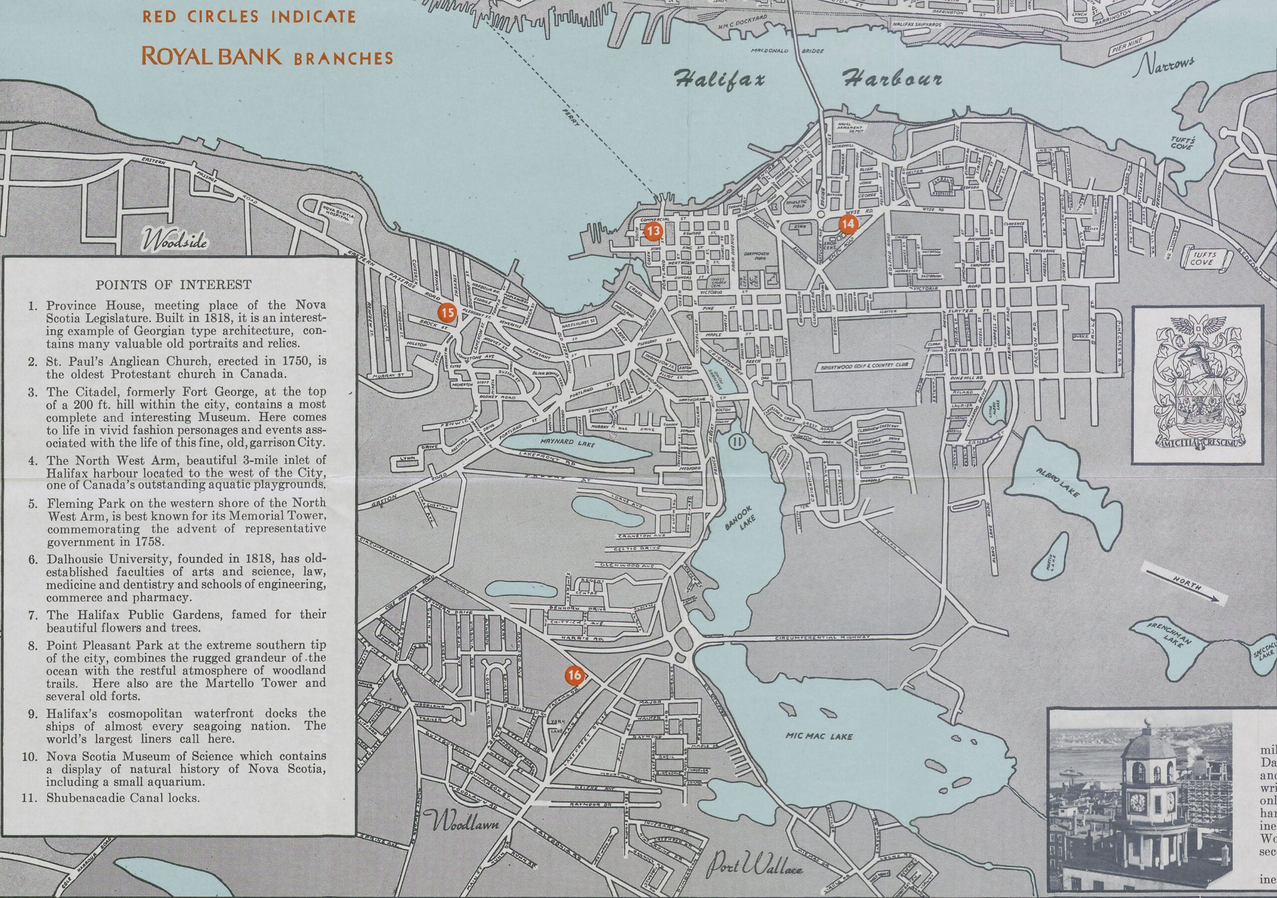
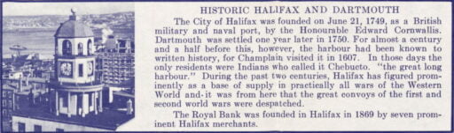
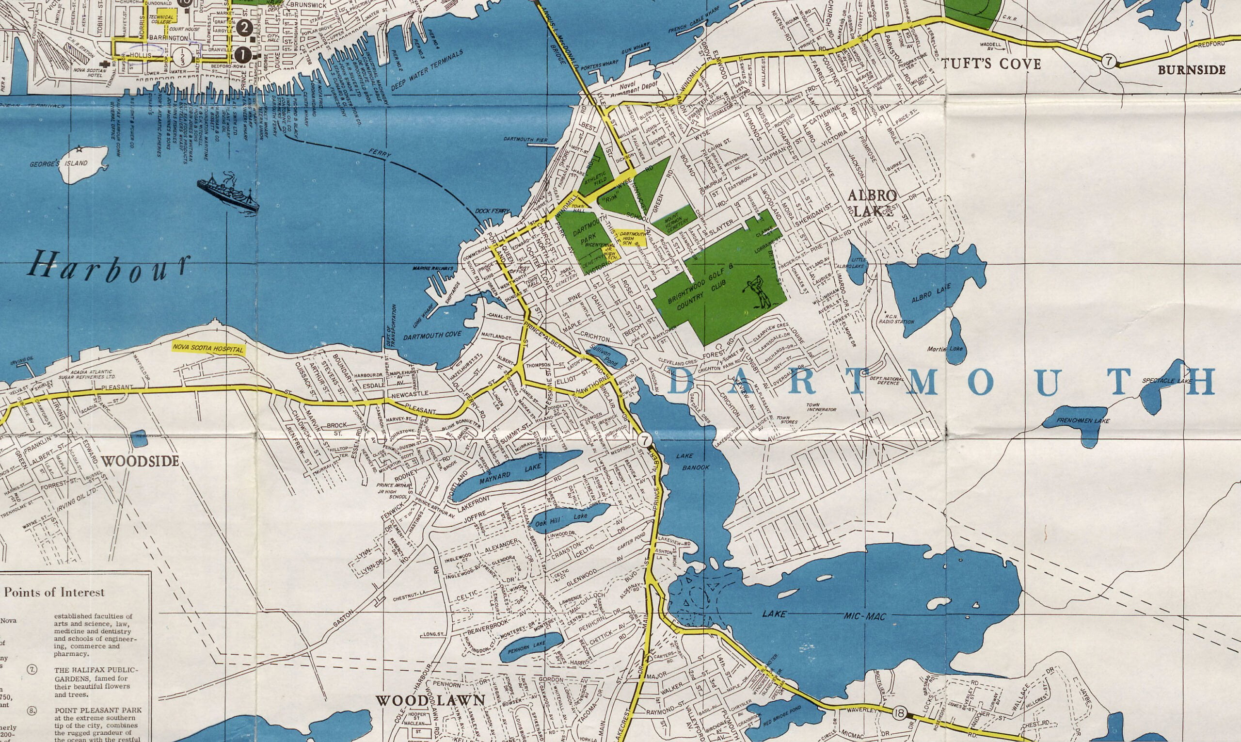

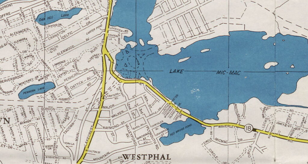

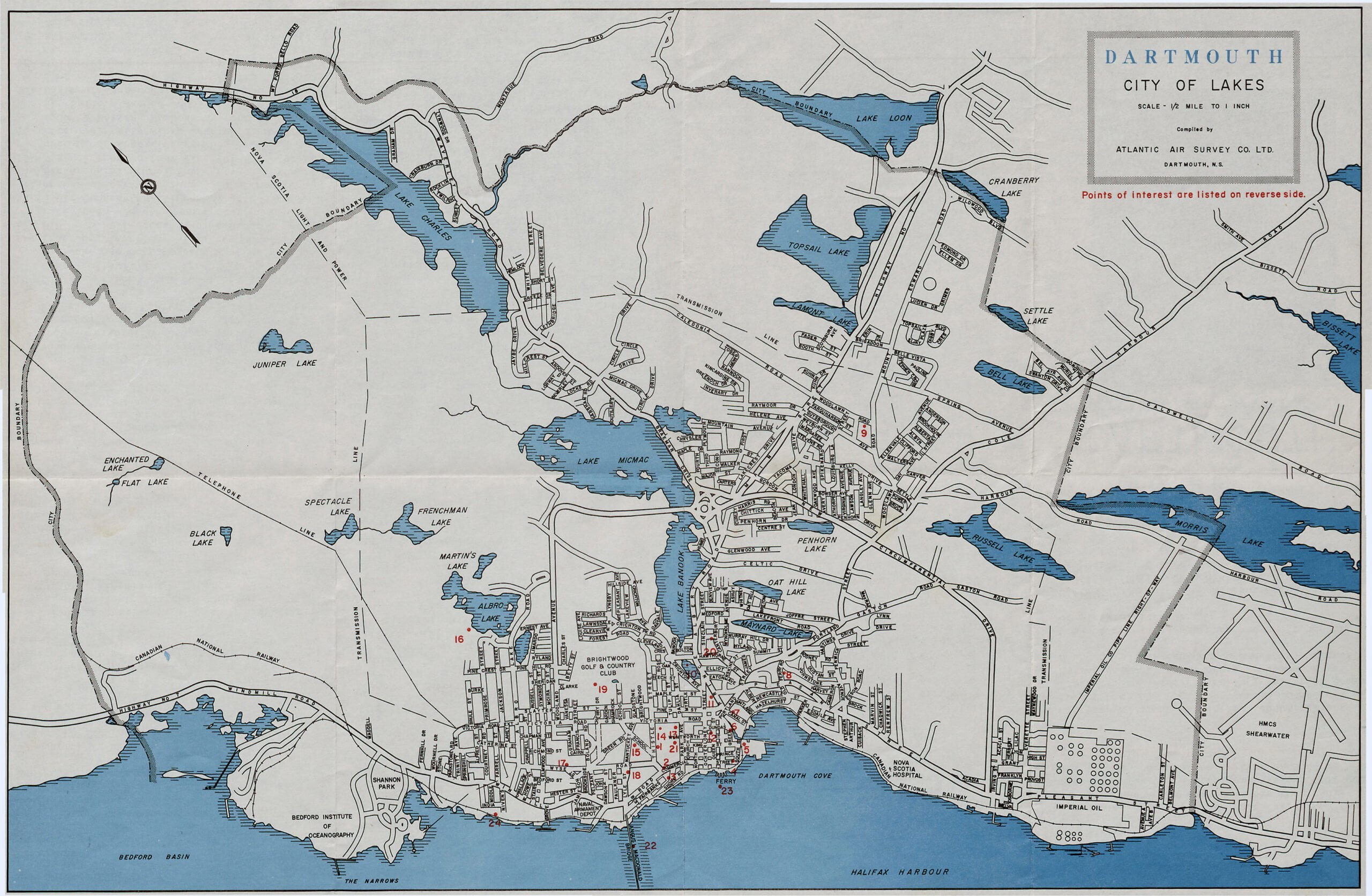
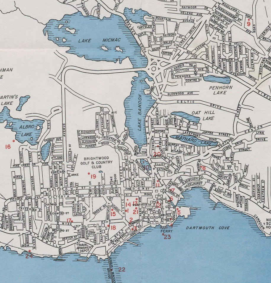

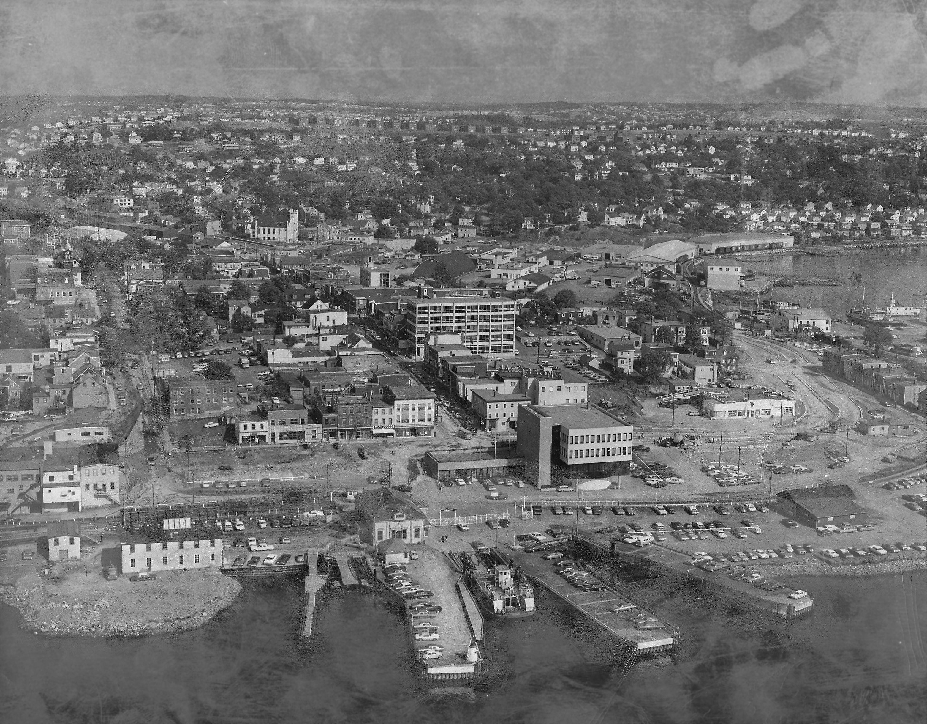
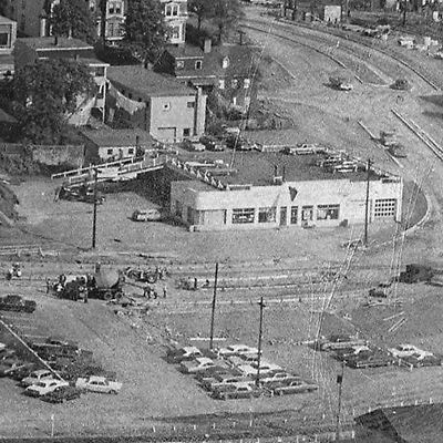
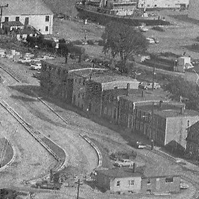
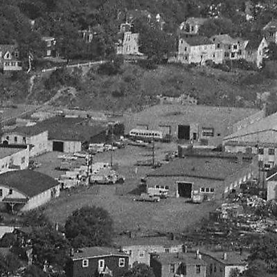
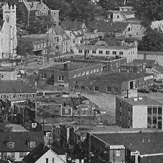
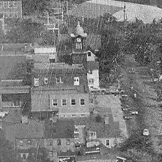
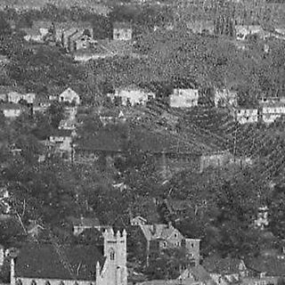
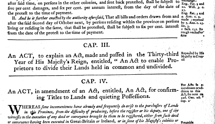
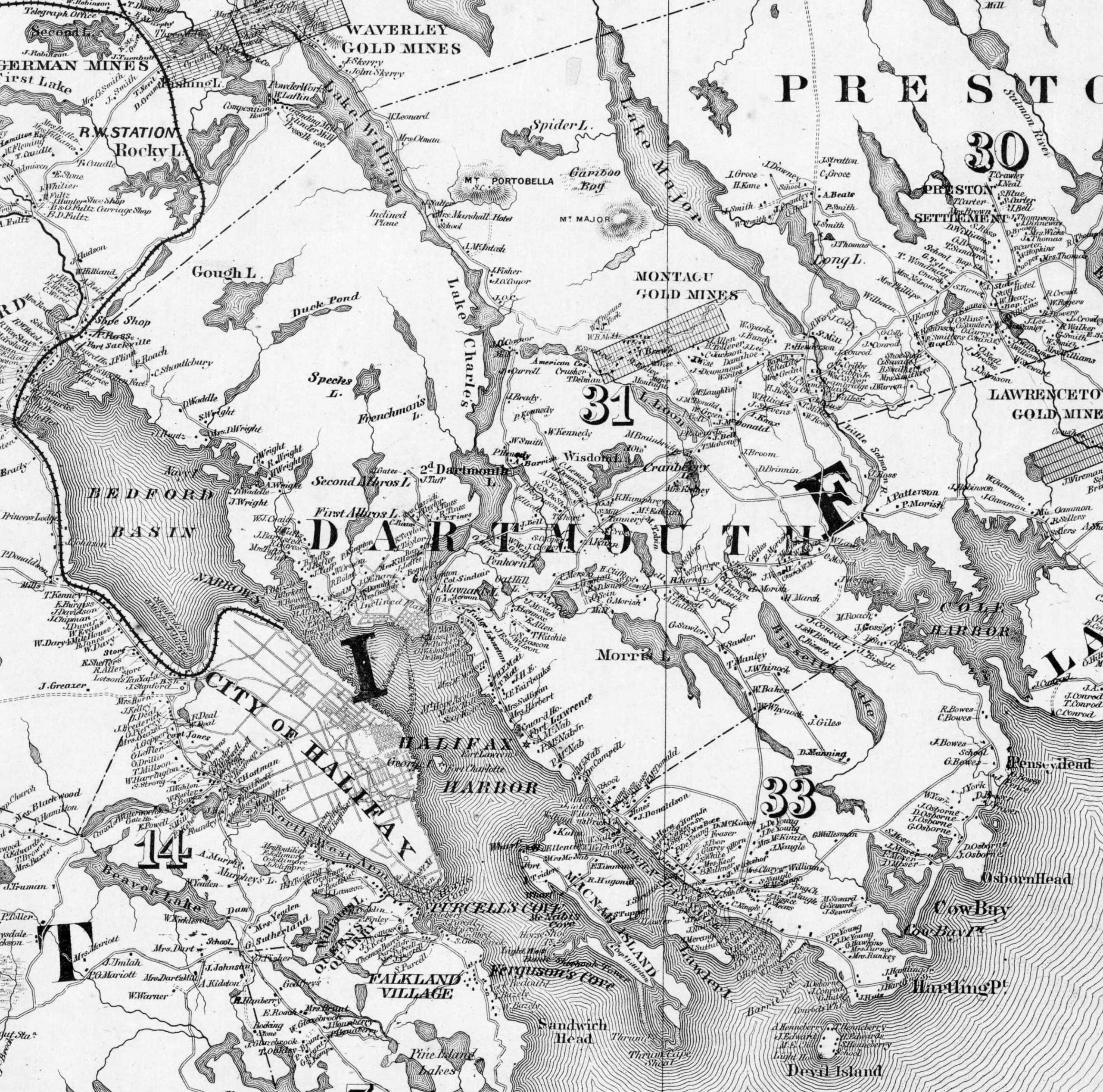
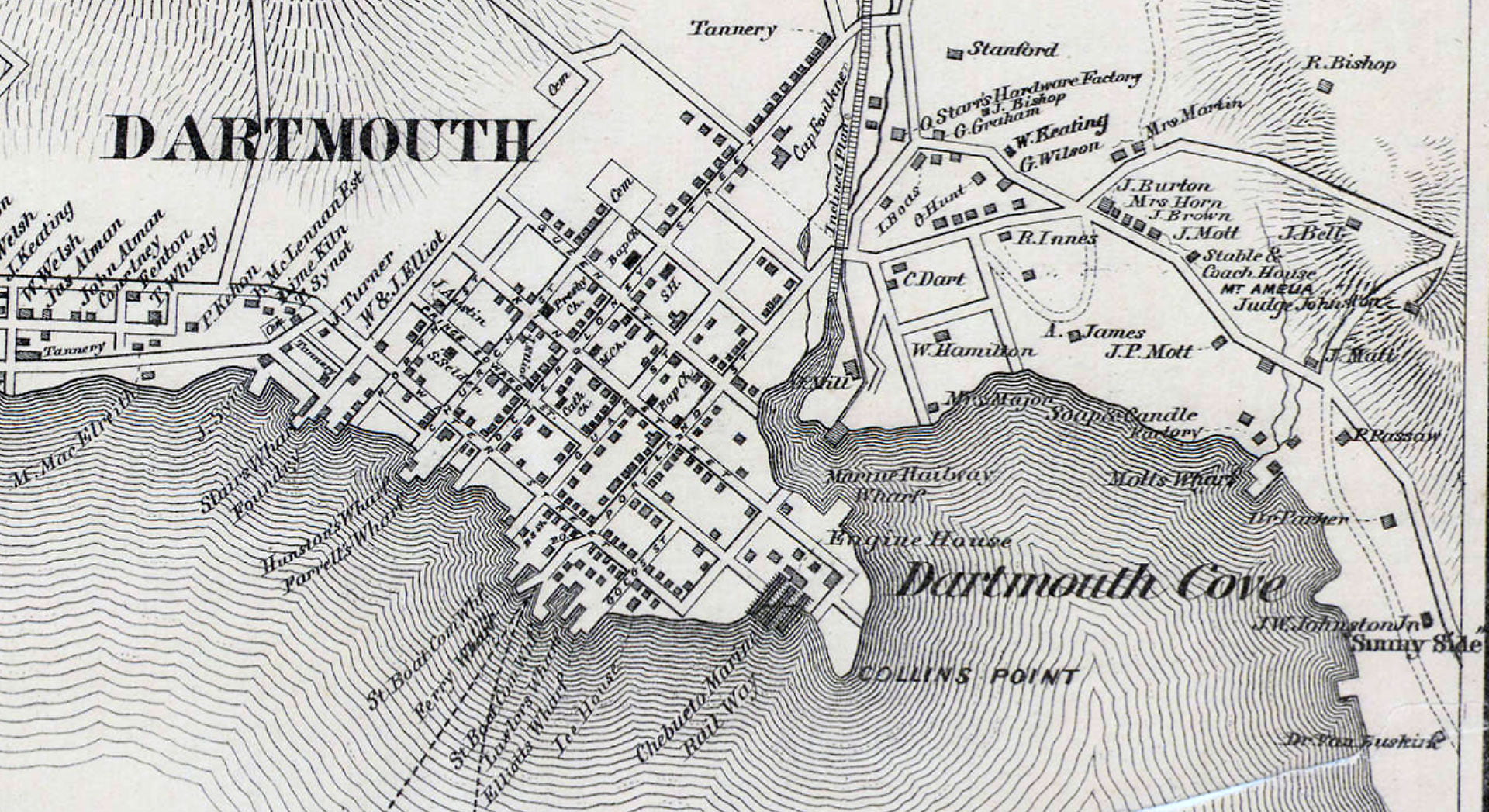
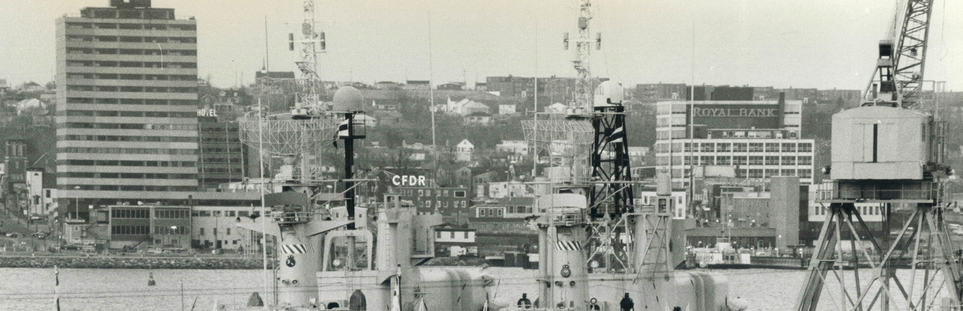
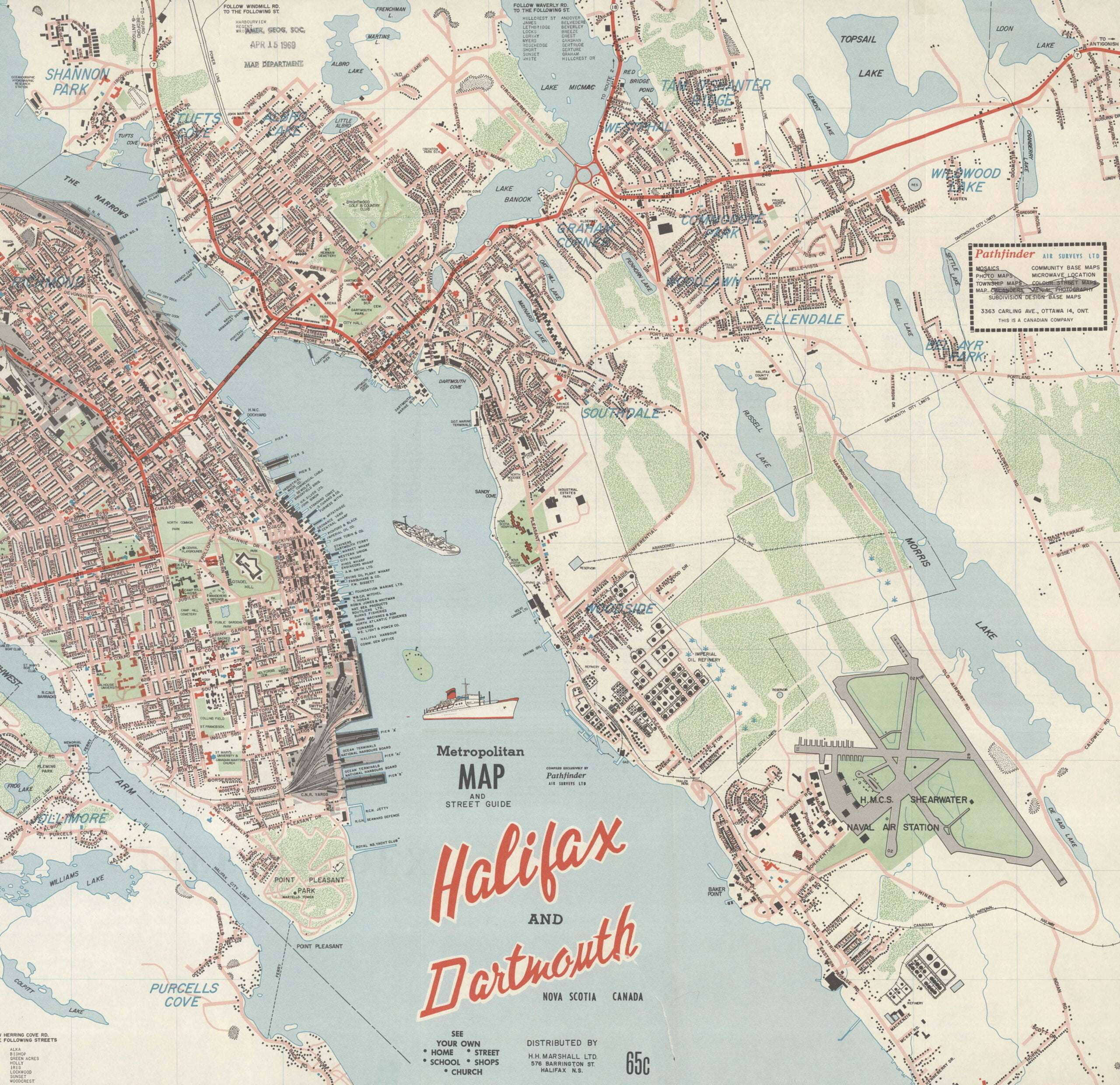
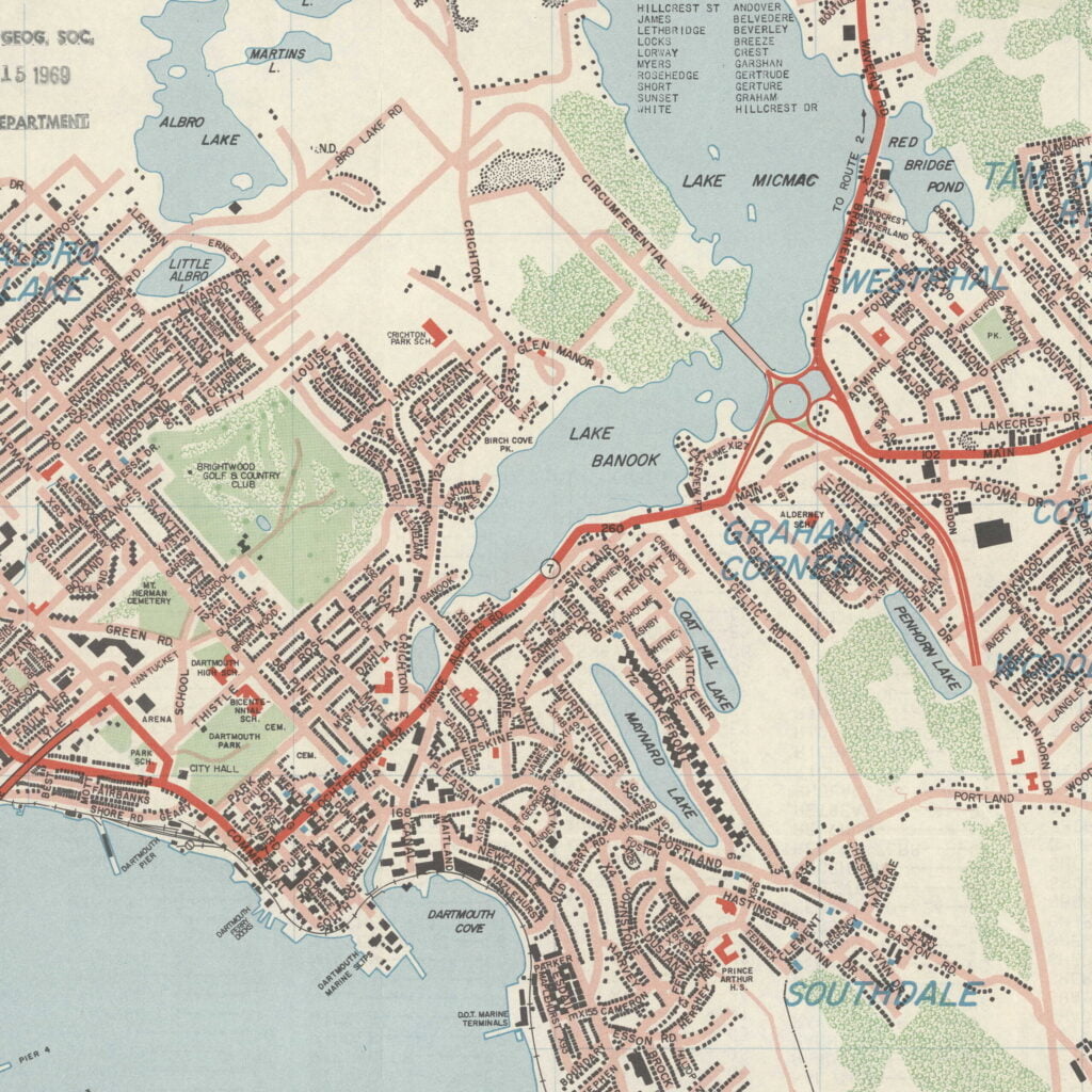
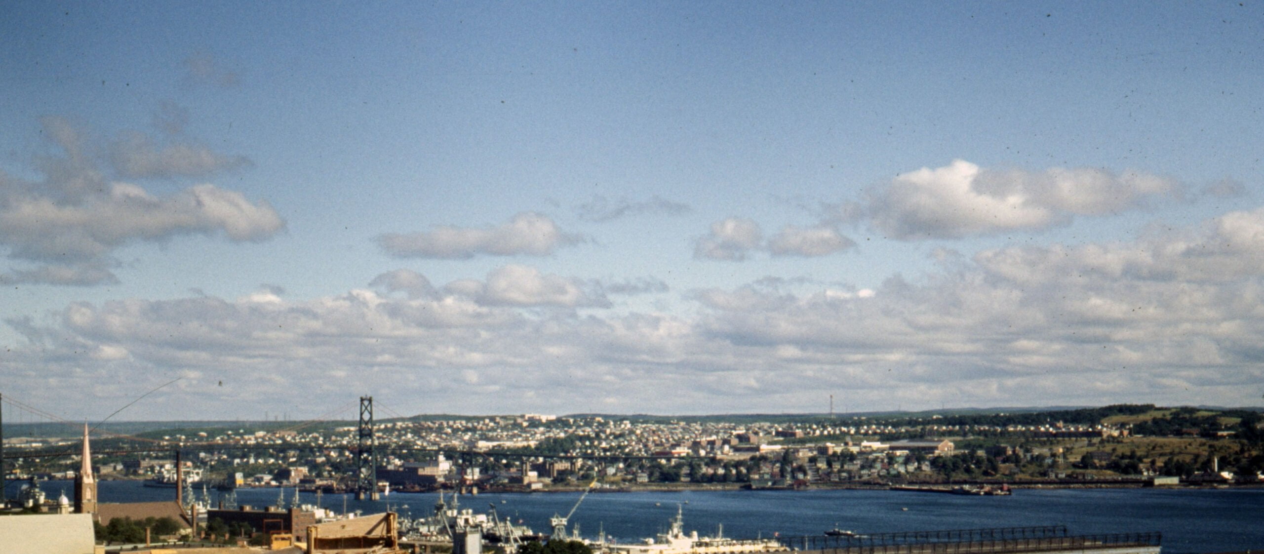
