
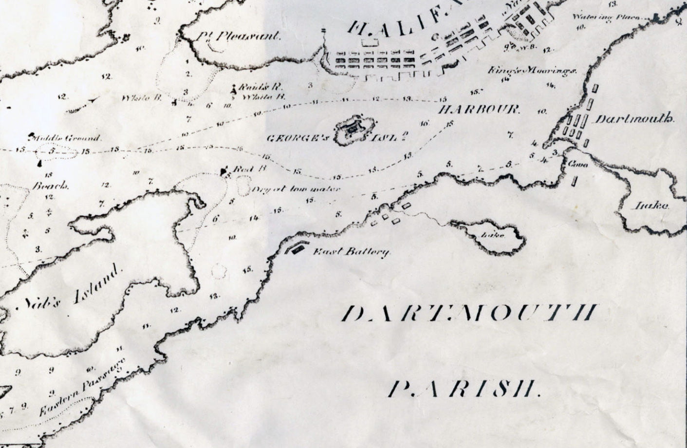
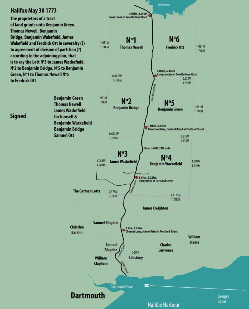
“Dartmouth Parish”, noted once again.
“The Harbour of Halifax Nova Scotia”, William Smyth, 1824. https://archives.novascotia.ca/maps/archives/?ID=395

Amicitia Crescimus
“Dartmouth Parish”, noted once again.
“The Harbour of Halifax Nova Scotia”, William Smyth, 1824. https://archives.novascotia.ca/maps/archives/?ID=395
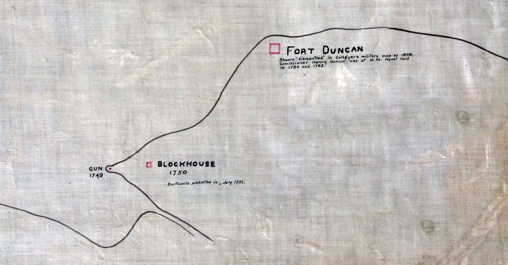

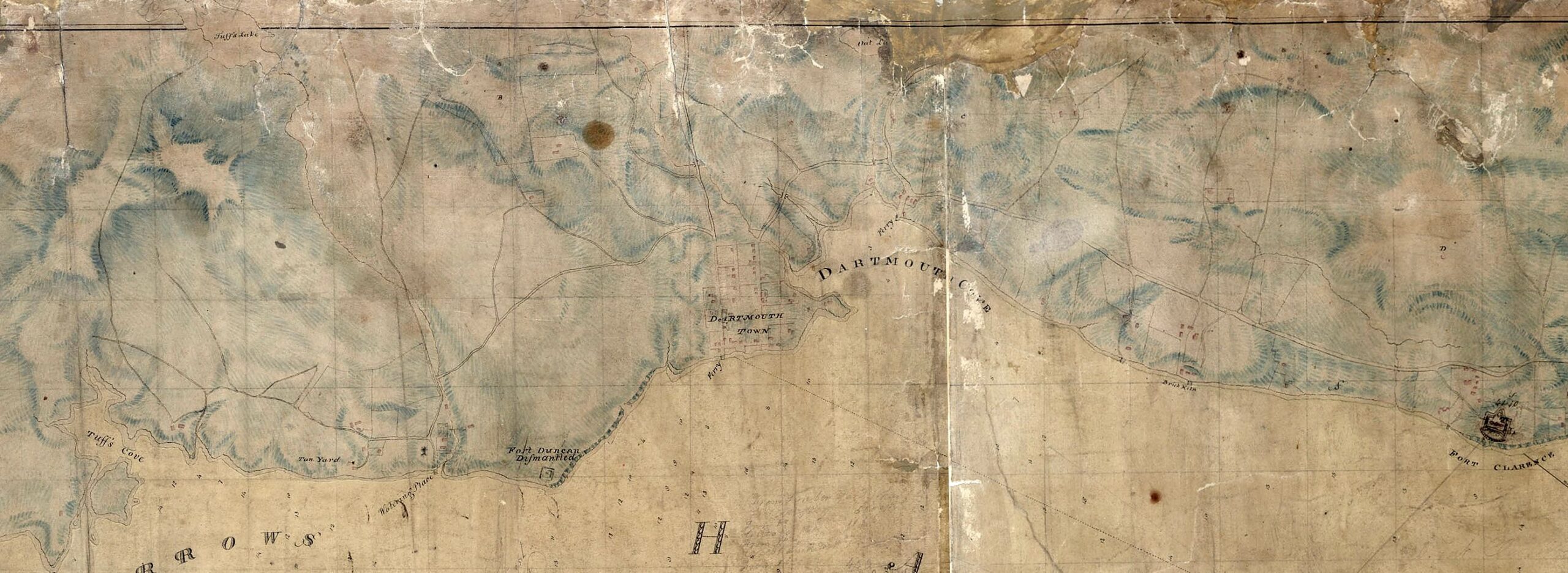
Fort Duncan: Shown “dismantled” in Collyers military map of 1808. Commissioner Henry Duncan was at H.M Naval Yard in 1790 and 1793.
Blockhouse: 1750. Dartmouth picketed in, July 1751.
Gun: 1749.

Eastern Battery, Fort Clarence: 1754. Freestone tower there in Jan 1810 & in 1834. Tower removed about 1865, when new works were begun. Fort Clarence reconstructed 1865 to 1868 (Mil. recds). Site sold to Imperial Oil Co, 1927. Known as Eastern Battery in 1786.
“Halifax Fortifications”, 1928. https://archives.novascotia.ca/maps/archives/?ID=1443

A noteable map for the fact that it shows the location of Pace’s Cove, used to determine the bounds of the Township of Dartmouth.
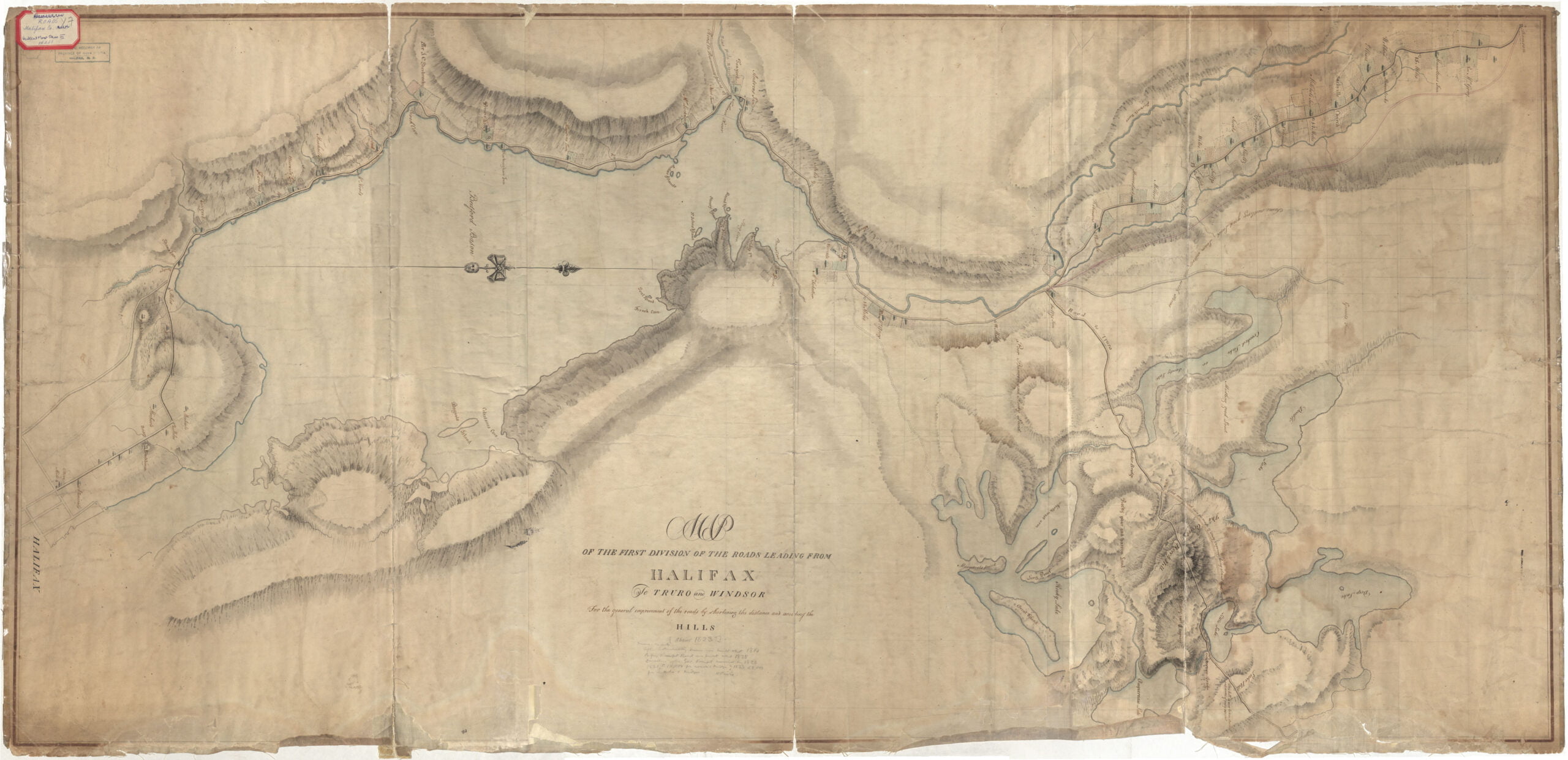
“Roads from Halifax to Truro & Windsor”, 1823. https://archives.novascotia.ca/maps/archives/?ID=392
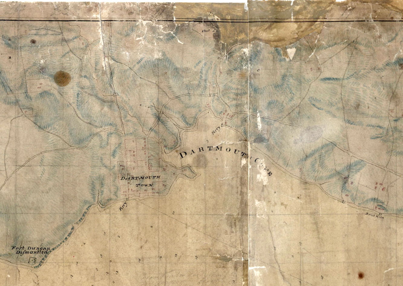
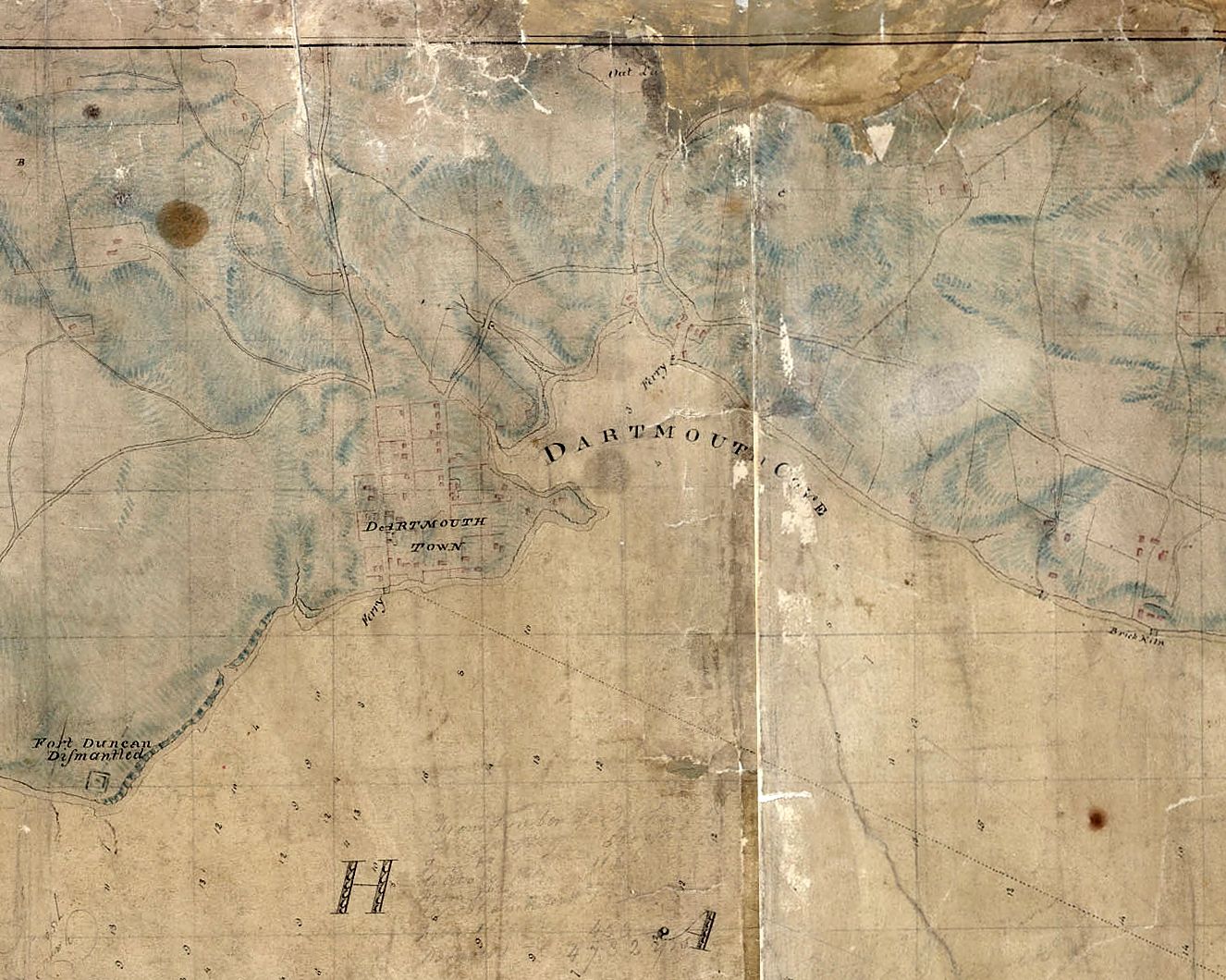
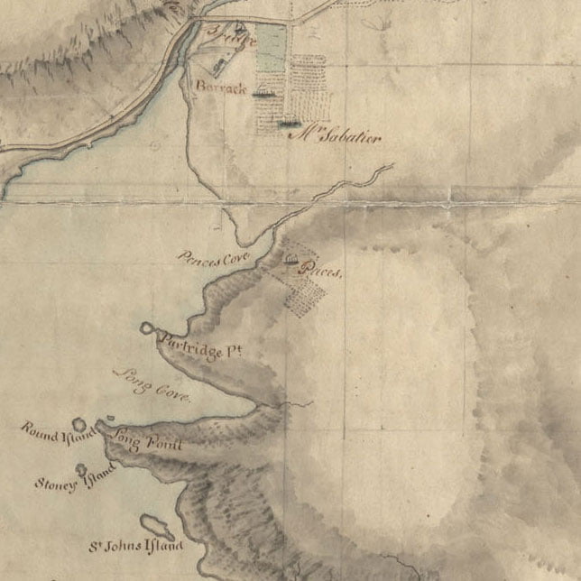
A very detailed rendition of the Dartmouth shore from 1808. Skerry’s ferry at Ochterloney is seen as well as Creighton’s Ferry at the bottom of Old Ferry Road. Fort Duncan can be seen near where Shore Road meets Lyle Street today. Bridges are seen spanning Portland Street at Maitland, and what would be Pleasant Street just before Old Ferry Road as well as Ochterloney Street as it intersects with the Mill stream, now the Shubenacadie River.
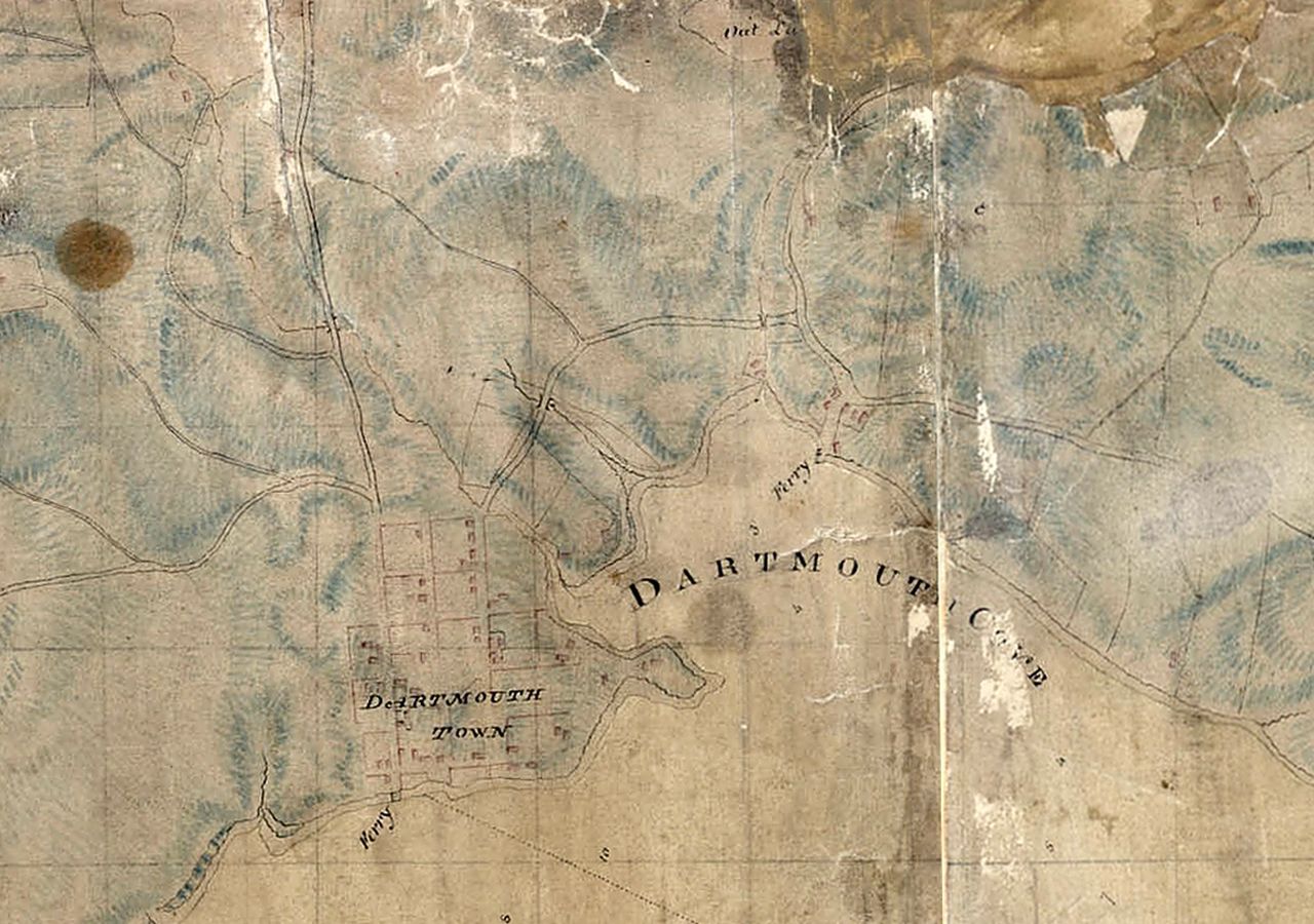
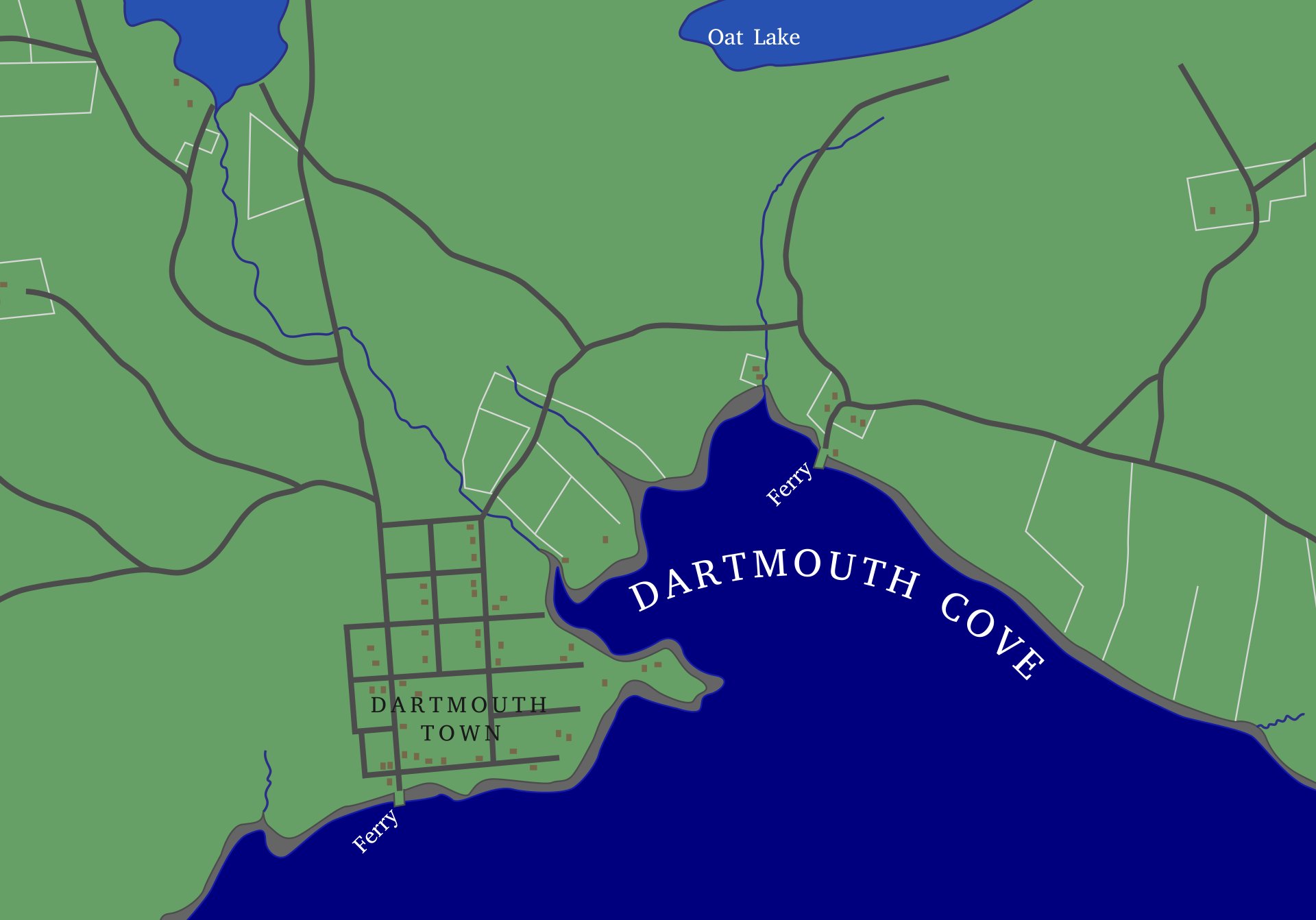
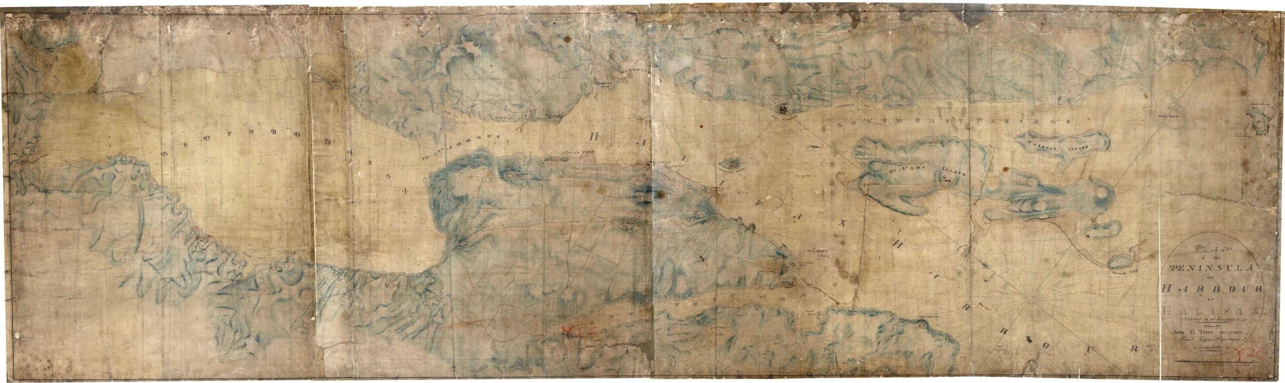
“Peninsula and harbour of Halifax”, John G. Toler, 1808. https://archives.novascotia.ca/maps/archives/?ID=257
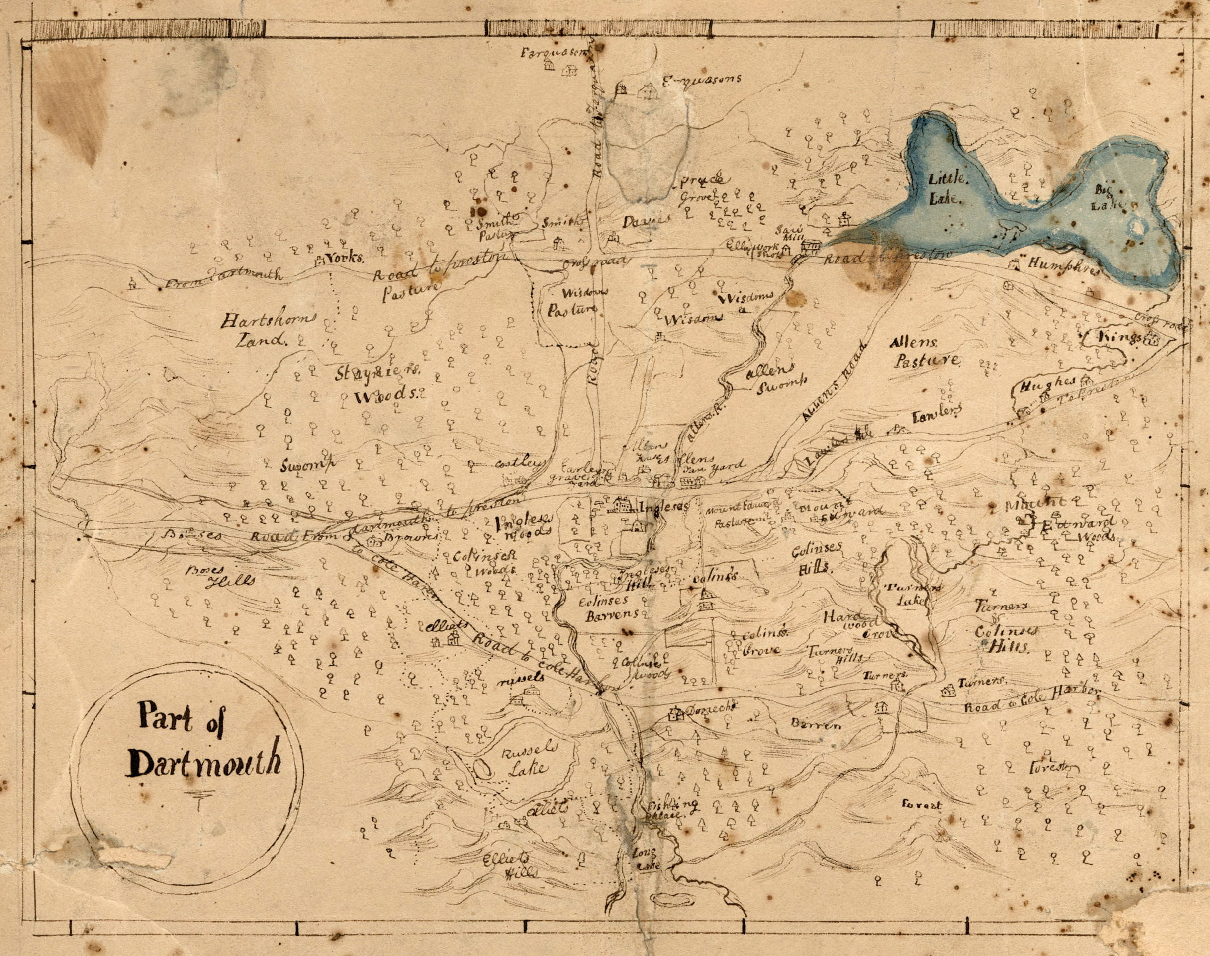
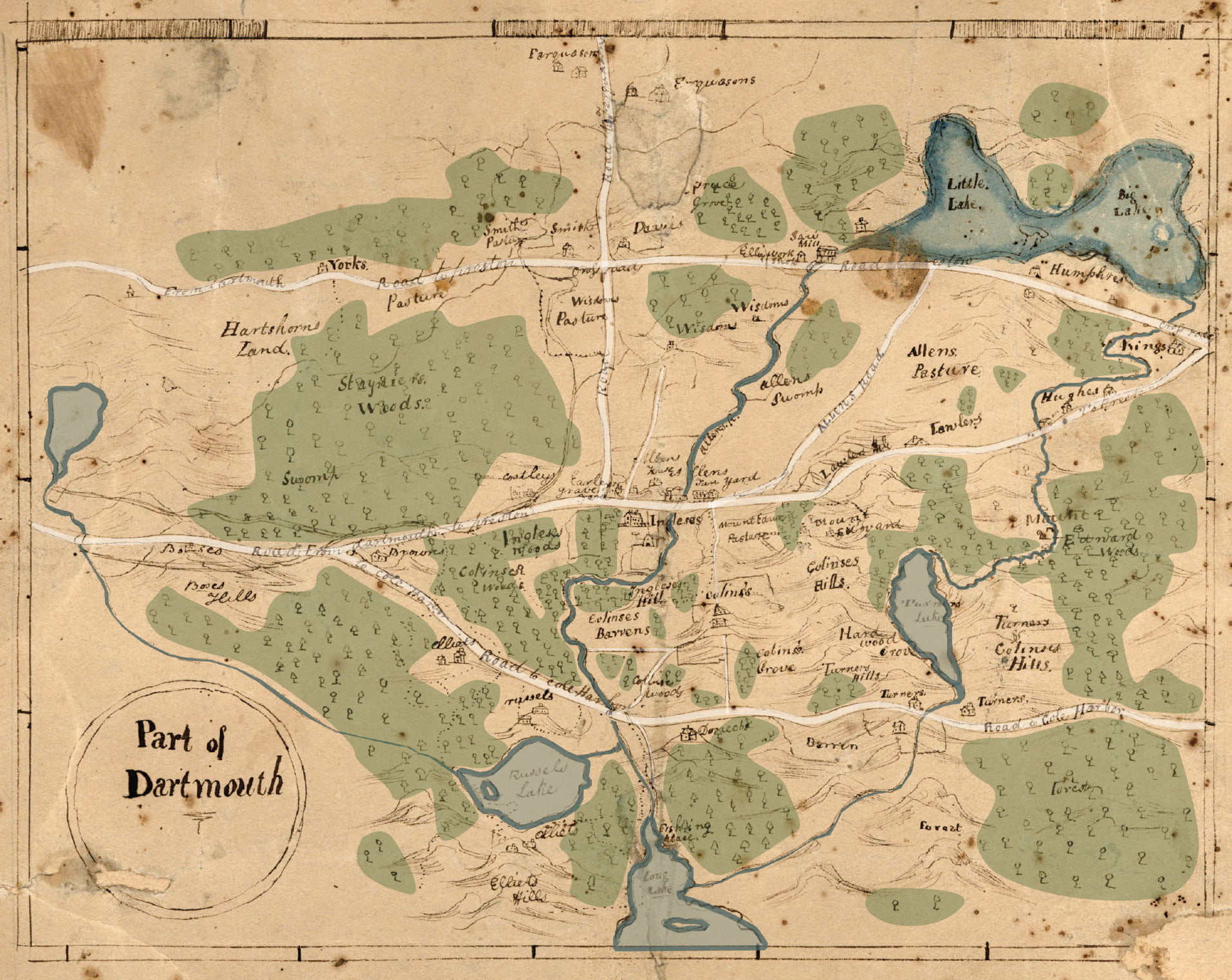
The Dartmouth they’re referring to here appears to be Dartmouth Township, since it wasn’t yet incorporated as a Town or City in 1820. Here’s a quick coloration in order to hopefully ease legibility: Penhorn Lake can be seen at far left, Russell and Morris Lake along the bottom, Bell Lake at middle right. What is now Main Street, then known as “Road to Preston”, travels from left to right at top. The “Road from Dartmouth to Preston” at middle is now Woodlawn Road and Mount Edward Road, “Road to Cole Harbor” at bottom, once the road to Lawrencetown is now Portland Street. Road to Farquharson’s, the vertical road at middle, is now Caledonia Road. I believe there’s still a very small piece of “Allen’s Road” extant, which connected what is now Mount Edward Road to Main Street, as seen here.
See also:
"Part of Dartmouth", 1820. https://archives.novascotia.ca/maps/archives/?ID=384
From The Story of Dartmouth, by John P. Martin:
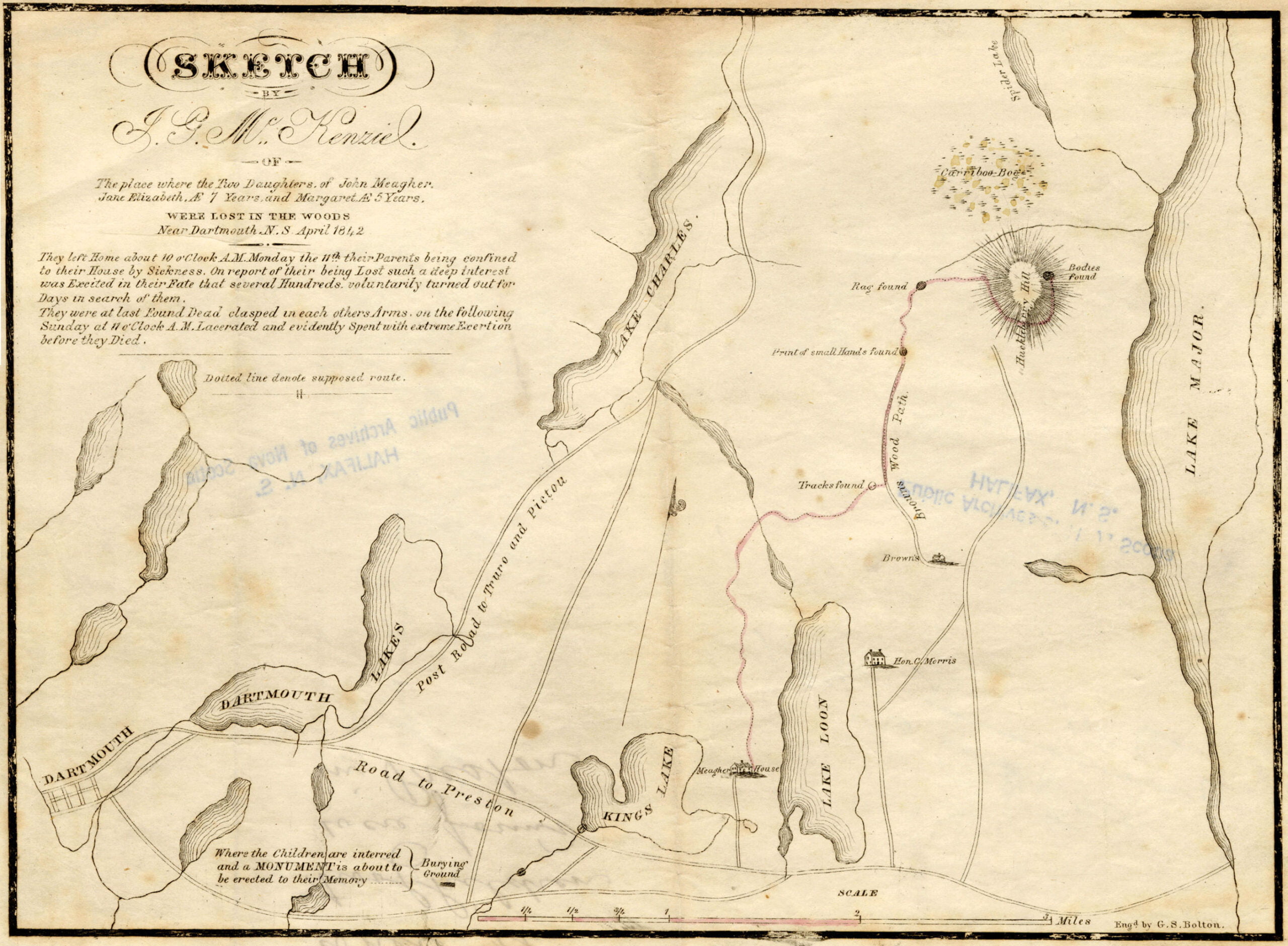
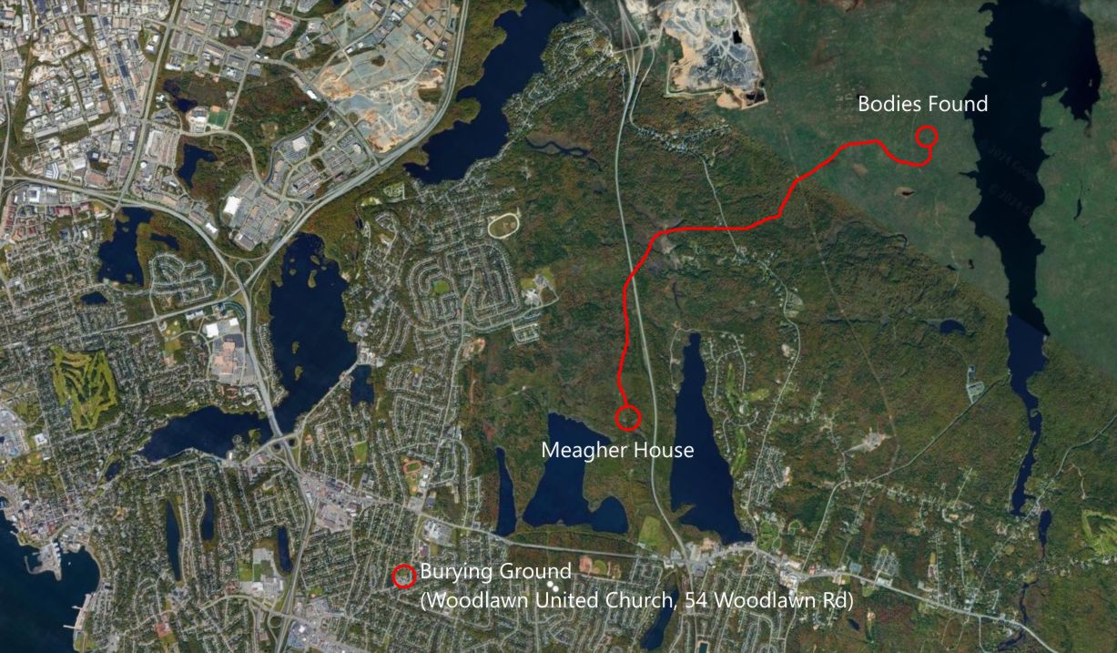
In mid-April 1842, the greatest excitement was aroused in Dartmouth and Halifax by the loss of two little girls, who were the daughters of Mr. and Mrs. John Meagher, occupants of a farm at Lake Loon at the northern extremity of Barker Road on no. 7 highway.
These children were Jane Elizabeth and Margaret Meagher, aged 6 years and 4 years, respectively. They wandered into the woods near their home on a beautifully warm Monday morning, the 11th day of April. The eldest sister of the family was busy with household duties, while the mother with a new-born babe was still confined to her room. Unfortunately also, the father was laid up at the time with an attack of measles.
When the little ones did not return by late afternoon, the hired man searched far into the woods at the rear of the field, but returned unsuccessful. Then the father rose from his sick bed, and with the help of neighbors carrying lighted brands, tramped deeper and deeper into the pathless forest loudly calling the names of Jane and Margaret, but all they got for their efforts was a rebound of the eerie echoes of their voices from the distant tree-tops.
When news reached town on Tuesday, hundreds of volunteers hastened from Halifax and Dartmouth to assist in the hunt. Hope was aroused when the searchers saw footprints in the snow, and also learned from a young Black man named Brown, who lived about two miles from Meagher’s on the opposite side of Lake Loon, that he had heard voices of children crying on the previous evening.
During the whole of that week, an ever-increasing crowd of volunteers comprising neighbors, farmers, Frenchmen, Mi’kmaq, sailors, soldiers, merchants and professional men, threaded nearly every foot of that vast forest until it seemed as if the whole countryside had been combed. Meantime, the weather had grown so cold that it was the general conviction the children must have perished.
Halifax newspapers, nevertheless, issued an appeal for every available man to assemble at Dartmouth on Sunday, April 17, for a combined and organized effort. Nearly three thousand responded. They were determined that the forest should reveal its secret. And it did.
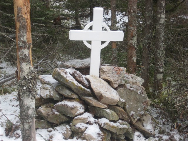
About noon that day the bodies were found on a hill at the head of Lake Major, almost two miles east of the village of Montague. The hero of the hunt was a shepherd dog named “Rover”, scouting in the company of Peter Currie, a neighbor of John Meagher. “Rover” had suddenly sniffed the trail of the babes, and with his nose in the scraggy turf, scurried up a hill to the sheltered side of a high boulder. There he stopped and barked excitedly.
The children were found locked in each other’s arms. The younger one had her cheek tightly pressed against the face of her sister. Young Margaret’s features were calm and peaceful as if she had met death in sleep. Elizabeth’s face, however, plainly showed traces of fear and anxiety, and spoke of days of cold, of hunger and terror. Their tender arms and legs were covered with scratches, and their flimsy dresses in tatters. They had traveled about six miles.
The bodies were left undisturbed until the father was escorted to the spot. Many in that motley throng, now gathering around reverentially amid the awful presence of death, could not restrain a tear as the stricken parent knelt and lovingly embraced each lifeless form. Willing hands, working in relays, then carefully carried the precious burdens back to the Meagher home.
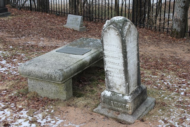
The remains were placed into one coffin, and two days later were interred in the historic cemetery at Woodlawn. A reward of £5 offered for their discovery, was turned over by Mr. Currie to head a fund for the erection of a headstone.
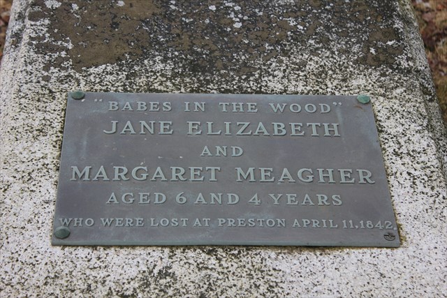
“Sketch by J.G. MacKenzie of the place where the two daughters of John Meagher, Jane Elizabeth 7 years and Margaret 5 years, were lost in the woods near Dartmouth. April, 1842.” https://archives.novascotia.ca/maps/archives/?ID=638&Page=201760573
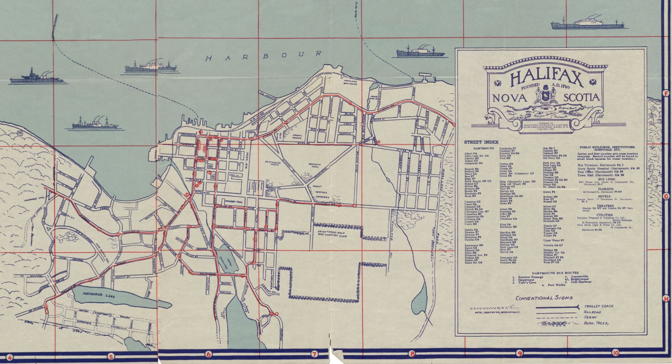
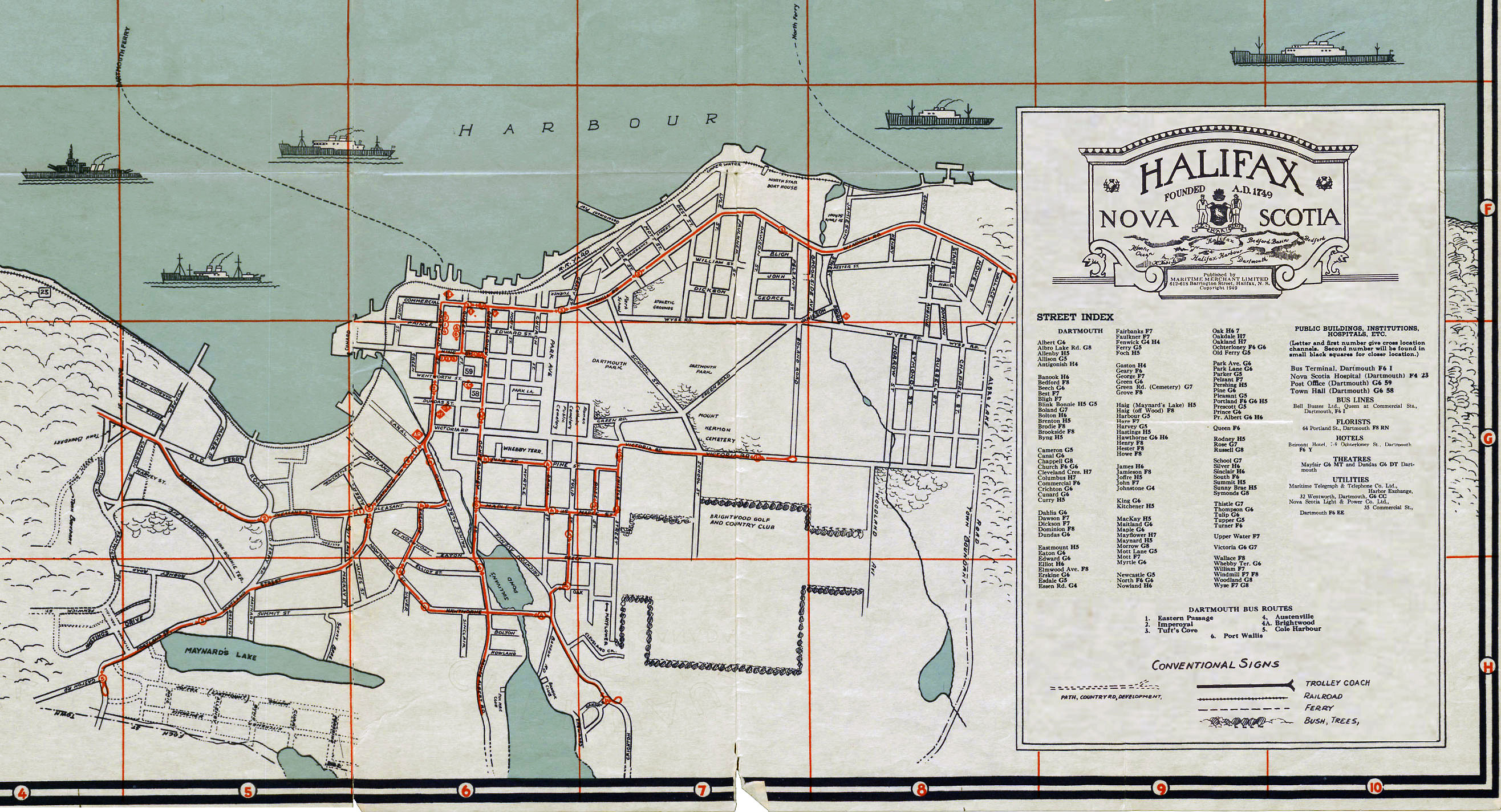
A noteworthy map since it shows Dartmouth Bus routes, seven of them (#1 Eastern Passage, #2 Imperoyal, #3 Tuft’s Cove, #4 Austenville, #4A Brightwood, #5 Cole Harbour, #6 Port Wallace); operated by Bell Bus Lines at the time.
Among the public buildings, institutions, hospitals etc. noted in Dartmouth: (“Letter and first number give cross location channels. Second number will be found in small black squares for closer location“)
Bus Terminal, Bell Busses Ltd., Queen at Commercial Streets (F6 I), Nova Scotia Hospital (F4 23), Post Office (G6 59), Town Hall (G6 58).
Florist: 64 Portland Street (F8 RN), Hotels: Belmont Hotel, 7-9 Ochterloney Street (F6 MT), Theatres: Mayfair (G6 MT) and Dundas (G6 DT), Utilities: Maritime Telegraph & Telephone Co. Ltd., Harbor Exchange, 32 Wentworth Street (G6 CC), Nova Scotia Light & Power Co. Ltd., 35 Commercial Street (F6 EE)
Street Index:
Albert (G6), Albro Lake Rd. (G8), Allenby (H5), Allison (G5), Antigonish (H4)
Banook (H6), Bedford (F8), Beech (G6), Best (F7), Bligh (F7), Blink Bonnie (H5, G5), Boland (G7), Bolton (H6), Brenton (H5), Brodie (F8), Brookisde (F8), Byng (H5)
Cameron (G5), Canal (G6), Chappell (G8), Church (F6, G6), Cleveland Cres. (H7), Columbus (H7), Commercial (F6), Chrichton (G6), Cunard (G6), Curry (H5)
Dahlia (G6), Dawson (F7), Dickson (F7), Dominion (F8), Dundas (G6)
Eastmount (H5), Eaton (G6), Edward (G6), Elliot (H6), Elmwood Ave (F8), Erskine (G6), Esdale (sic) (G5), Essen Rd. (G4)
Fairbanks (F7), Faulkner (F7), Fenwick (G4, H4), Ferry (G5), Foch (H5)
Gaston (H4), Geary (F6), George (F7), Green (G6), Green Rd. (Cemetery) (G7), Grove (F8)
Haig (Maynard’s Lake) (H5), Haig (off Wood) (F8), Harbour (G5), Hare (F7), Harvey (G5), Hastings (H5), Hawthorne (G6, H6), Henry (F8), Hester (F8), Howe (F8)
James (H6), Jamieson (F8), Joffre (H5), John (F7), Johnstone (G4)
King (G6), Kitchener (H5)
MacKay (H5), Maitland (G6), Maple (G6), Mayflower (H7), Maynard (H5), Morrow (G8), Mott Lane (G5), Mott (F7), Myrtle (G6)
Newcastle (G5), North (F6, G6), Nowland (H6)
Oak (H6, H7), Oakdale (H7), Oakland (H7), Ochterloney (F6, G6), Old Ferry (G5)
Park Ave. (G6), Park Lane (G6), Parker (G5), Pelzant (F7), Pershing (H5), Pine (G6), Pleasant (G5), Portland (F6, G6, H5), Prescott (G5), Prince (G6), Pr. Albert (G6, H6)
Queen (F6)
Rodney (H5), Rose (G7), Russell (G8)
School (G7), Silver (H6), Sinclair (H6), South (F6), Summit (H5), Sunny Brae (H5), Symonds (G8)
Thistle (G7), Thompson (G6), Tulip (G6), Tupper (G5), Turner (F6)
Upper Water (F7)
Victoria (G6, G7)
Wallace (F8), Whebby Ter. (G6), William (F7), Windmill (F7, F8), Woodland (G8), Wyse (F7, G8)
“The Only Authentic Map of the City of Halifax and Town of Dartmouth, NS”, Maritime Merchant Ltd, 1949. https://archives.novascotia.ca/maps/archives/?ID=1569&Page=202012442
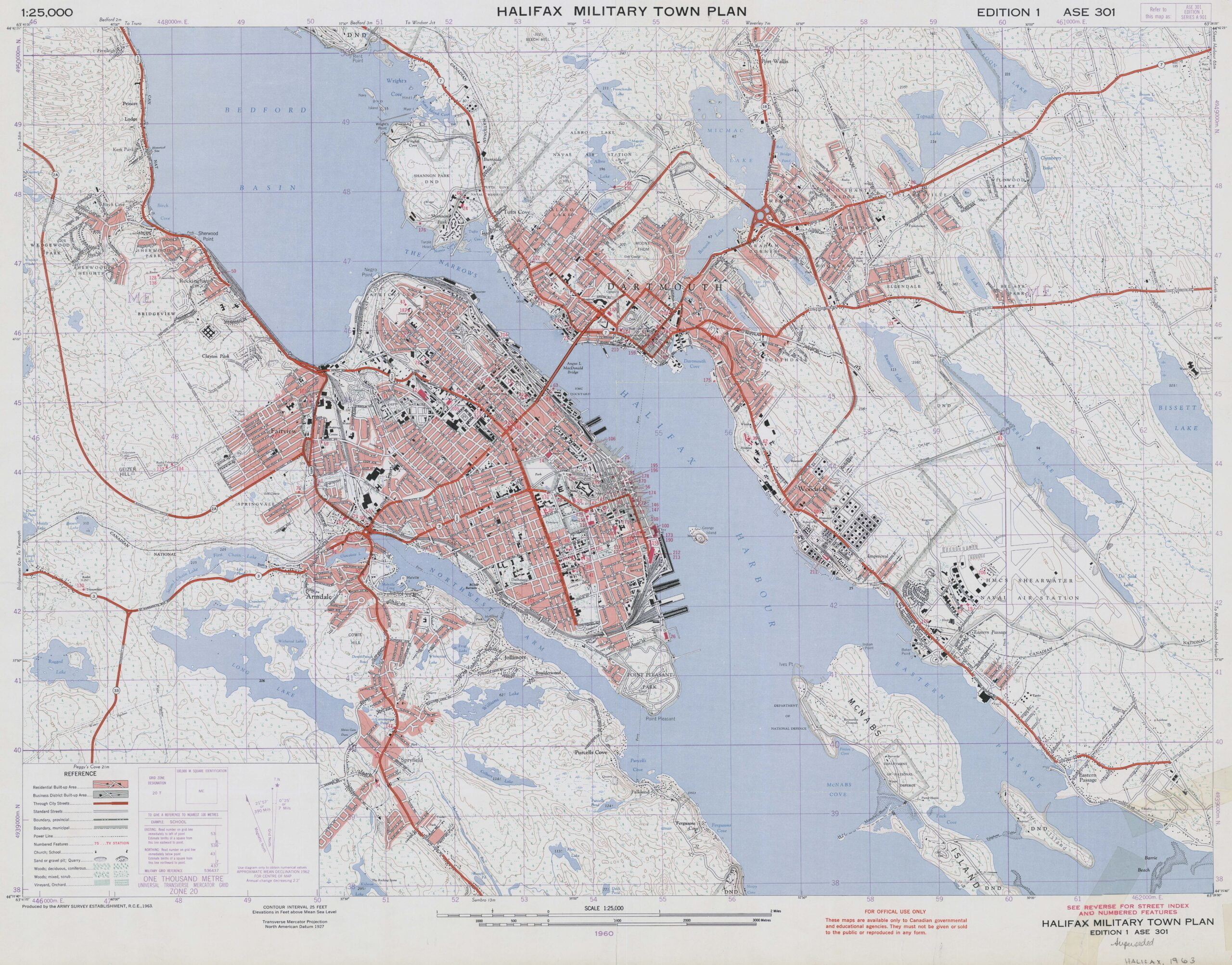
“Halifax Military Town Plan”, Military town plan, series A901 ; ASE 301. 1st ed. “Produced by the Army Survey Establishment, R.C.E., 1963.” https://gallica.bnf.fr/ark:/12148/btv1b53209890m
From The Story of Dartmouth, by John P. Martin:
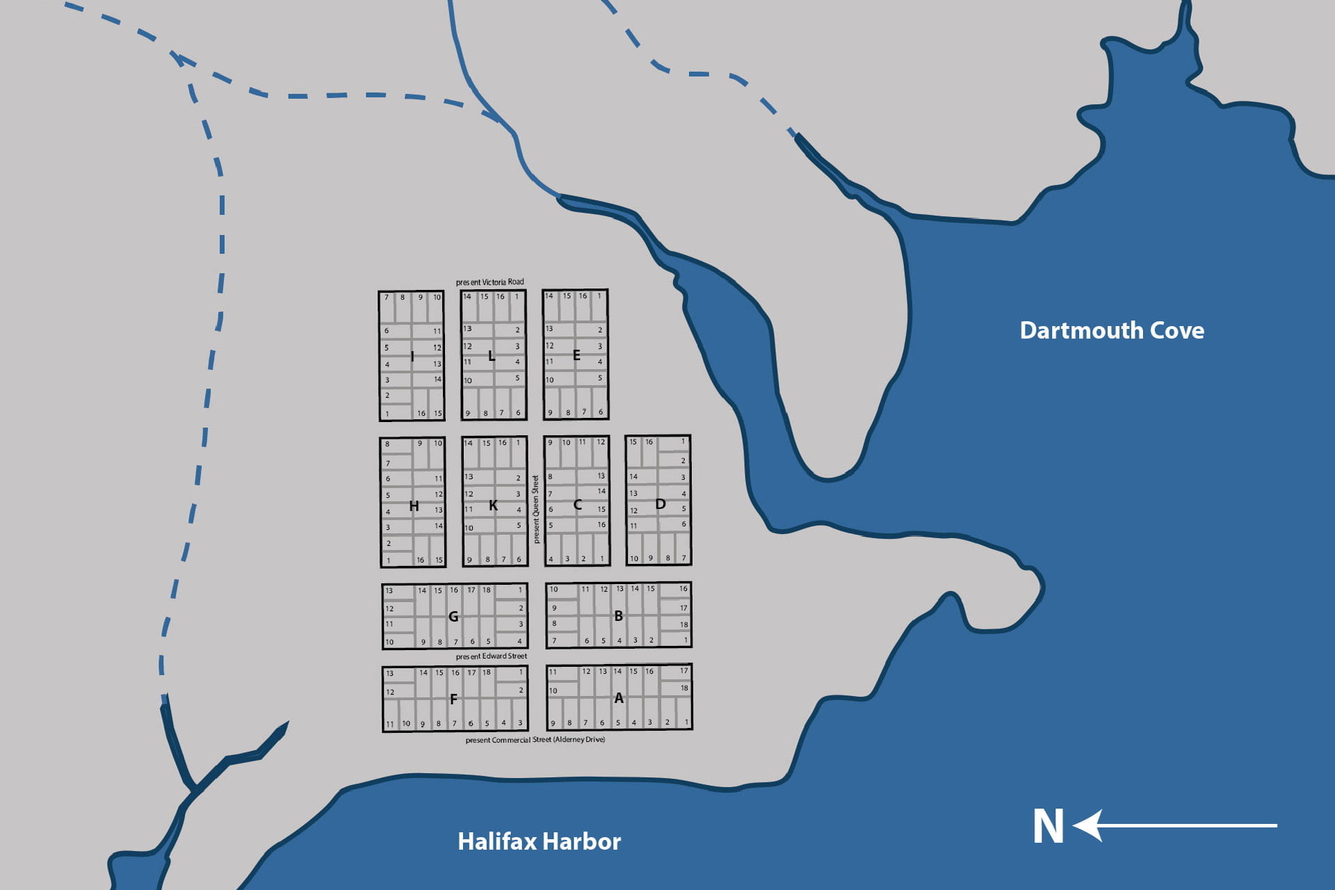
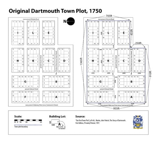
“The town plot as laid out in 1750 comprised of 11 oblong-shaped blocks, mostly 400 feet long by 200 feet wide. Each building lot was 50 feet by 100 feet. Reference to the cut shows that all the streets running north and south, lead to the point, which is the front part of the settlement. The northern boundary at the left side seems to be the present line of North Street. The southern boundary is the present Green Street, if it were produced through to Commercial Street (Alderney Drive). All the area from that line to the point would be the 10 acre grant of Benjamin Green.”
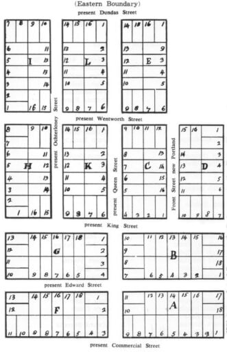
“The eastern boundary is at Dundas Street, and from there the present Queen Street extends through the middle of the plot to Commercial St. (Alderney Drive). But Portland and Ochterloney Streets come to a dead end at King Street. (No street names appear on the first plan).”
Was the eastern boundary actually at Dundas Street? I’ve always been a little confused by the original town plot and by the visual representation of it as seen above. That so much of the town was escheated and replotted with the arrival of the Quakers, that new street widths, block sizes and lot sizes were used thereafter doesn’t help the situation.
Martin notes the town plot consisted of “11 oblong blocks, mostly 400 feet long and 200 feet wide. Each building lot was 50 feet by 100 feet.”
Only four of the blocks (“A”, “B”, “F” and “G”) had 18 building lots. Since the building lots are 100 x 50 feet, and the other 7 blocks (“C”, “D”, “E”, “H”, “I”, “K”, and “L”) had 16 building lots, perhaps this is the source of the discrepancy in block size?
Martin points out that the part of Edward Street known as Chapel Lane (between Ochterloney and Queen) retains the original street widths, at 55 feet, so I used the South West corner of Chapel Lane and Queen with which to plot the old town plot.
200 feet west towards Alderney Drive (Block “F”), 450 feet North towards North Street (Block “F”), then 1365 feet East towards Victoria Road (passing Block “F”, “G”, “H” and “I”). I continued 710 feet south to Portland Street (Block “I”, “L” and “E”), 455 feet west along Portland Street (Block “E”, to the lane between 109 and 115 Portland Street), and then 255 feet south from there to Green Street (Block “D”). Plotting a further 910 feet west brings us back close to Alderney Drive (Blocks “D”, “B” and “A”); 450 feet north from there back to Queen Street (Block “A”, close to 55 feet from where we started).
It’s entirely possible my math is off or that I’m mistaken in my assessment, I certainly wouldn’t assume Martin missed something I picked up on, but it does seem to work out that it is Victoria Road that served as the eastern end of the town plot, and not Dundas Street.
The original 1750 Dartmouth town plot, the eastern boundary of which was thought to be at Dundas Street but may in fact be Victoria Road.
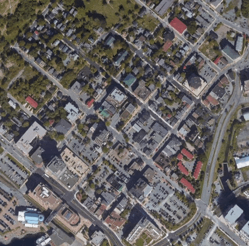
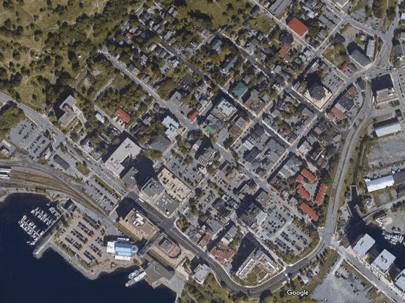
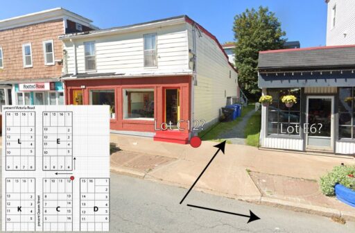
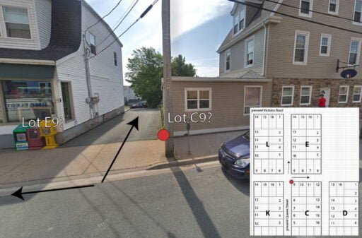
One thing that jumped out at me is the alley between 109 and 115 Portland Street (seen below, and at right the same alley from Queen Street). This would be at the south eastern corner of block “C”, lot 12 (or the north western corner of block “C”, lot 9 from the Queen Street side) — is this a remnant of the original town plot, proof that this was indeed the original town alignment? I’ve noticed a few other property alignment oddities that seem to back this up.
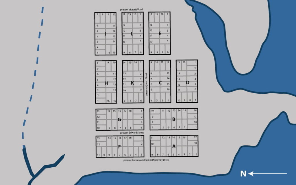
Reference the map above to locate by Block letter and lot number.
| Block Letter “A” | Block Letter “B” | Block Letter “C” | Block Letter “D” | ||||
| 1— | 1— | Matthew Staple | 1— | William Howard | 1— | Dr. John Baxter | |
| 2— | Josiah Rogerson | 2— | James McKensey | 2— | Abraham Mozar | 2— | Dr. John Baxter |
| 3— | James Lawrence | 3— | Ralph Nesham | 3— | Joseph Marken | 3— | |
| 4— | Joseph White | 4— | Wm. Manthorne | 4— | Albert Suremon | 4— | Robert Vowles |
| 5— | Daniel Breast | 5— | Thomas Hardin | 5— | Henry Claaser | 5— | John Hall |
| 6— | Joseph Scoffield | 6— | 6— | Abraham Walker | 6— | Cheyne Brownjohn | |
| 7— | Thomas Wiseman | 7— | Edward Potter | 7— | Joseph Gosterel | 7— | John Hill |
| 8— | Samuel Jones | 8— | Andrew Downing | 8— | 8— | Mary Clark | |
| 9— | 9— | William Moore | 9— | Thomas Stephens | 9— | Mary Clark | |
| 10— | William Cooper | 10— | Bruin Rankin | 10— | William Stephens | 10— | Mary Clark |
| 11— | 11— | Adolph Witherall | 11— | William Ross | 11— | Walter Clark | |
| 12— | John Dunnevan | 12— | Joseph Scott | 12— | Robert Brooks | 12— | Edward Stevens |
| 13— | William Steward | 13— | 13— | Reuben Hemsley | 13— | Thomas Bourn | |
| 14— | Daniel Budgate | 14— | 14— | 14— | Thomas Bourn | ||
| 15— | 15— | 15— | Dennis Doran | 15— | |||
| 16— | Josiah Rogerson | 16— | 16— | 16— | George Chreighton | ||
| 17— | 17— | ||||||
| 18— | John Dubois | 18— |
| Block Letter “E” | Block Letter “F” | Block Letter “G” | Block Letter “H” | ||||
| 1— | John Crooks | 1— | John MacDonald | 1— | 1— | ||
| 2— | 2— | Charles Germain (fenced) | 2— | William Carter | 2— | ||
| 3— | David McKey | 3— | Henry Sweetland | 3— | 3— | ||
| 4— | William Scraggs | 4— | Nathaniel Follet | 4— | 4— | William Nixon | |
| 5— | Samuel Blagdon | 5— | 5— | Eleazer Robinson | 5— | ||
| 6— | James Owen | 6— | John Orr | 6— | 6— | ||
| 7— | 7— | James Wright | 7— | 7— | |||
| 8— | Robert Sparks | 8— | 8— | 8— | |||
| 9— | 9— | 9— | 9— | ||||
| 10— | 10— | 10— | 10— | ||||
| 11— | John Hoopy | 11— | 11— | 11— | |||
| 12— | Robert Young | 12— | 12— | 12— | |||
| 13— | William Hall | 13— | 13— | 13— | |||
| 14— | 14— | 14— | 14— | ||||
| 15— | 15— | 15— | 15— | ||||
| 16— | Thomas Leuke | 16— | 16— | 16— | |||
| 17— | 17— | ||||||
| 18— | Joseph Cole | 18— |
| Block Letter “I” | Block Letter “K” | Block Letter “L” | |||
| 1— | 1— | 1— | |||
| 2— | 2— | 2— | |||
| 3— | 3— | 3— | |||
| 4— | 4— | 4— | Christian Bartlin by purchase | ||
| 5— | 5— | Edward Barton | 5— | ||
| 6— | 6— | Parkinson | 6— | John Williams | |
| 7— | 7— | ||||
| 8— | 8— | ||||
| 9— | Thomas Gunnel | 9— | |||
| 10— | Thomas Ruddles | 10— | |||
| 11— | John Orr | 11— | |||
| 12— | 12— | ||||
| 13— | 13— | ||||
| 14— | 14— | ||||
| 15— | 15— | ||||
| 16— | 16— |
“Memo— A fish lot to Ever Davison beginning at a stake on Mill River north 46° east 330 feet thence south 44° east to the beach 264 feet, thence on the Beach to above stake.
East and north in the vast township of Dartmouth, more large grants included those to Captain Clapham, William Magee, John Colebanks, James Quinn, Benjamin Bridges, Richard Prowse and others.
You will notice that in the lists of the 1750 grantees that most of them chose lots near the waterfront. Blocks like “G”, “H”, “I” and “K” were perhaps too close to the source of [indigenous] attacks. Or else, the Alderney group being fisherman, they naturally sought locations as near as possible to the beach. Ever Davison’s fish lot seems to have been in the vicinity of Weagle’s boat-building shop near Canal Street.”
“From that point all the way to Eastern Passage, larger areas ranging from 60 to over 200 acres, and fronting on the shore, were granted to people prominent among Cornwallis’ settlers. Adjoining Davison’s was that of Samuel Blackden (or Blagdon); next was John Salisbury at Hazelhurst Shore, then Charles Lawrence in the Department of Transport vicinity; William Steele, Richard Burkeley, Byron Finucane, Joseph Gerrish, Jacob Hurd, Charles Morris, Leonard Lockman, Rev. Aaron Cleveland, Rev. Mr. Tutty and others.
When the town was re-plotted for Nantucket whaling families in 1783, Portland and Ochterloney were extended through to Commercial St. (Alderney Drive), and the blocks were squared to have 240 feet on each side, as at present. The three oblong shaped blocks still standing in downtown Dartmouth have a driveway at the ends of Prince Street and Green Street, which suggests that all blocks of the new town were to be square shaped.
All the new lots measured 60 feet by 120 feet. Most of the streets were widened from 55 feet to 60. That part of Edward Street known as Chapel Lane seems to be the only relic of original street widths.”
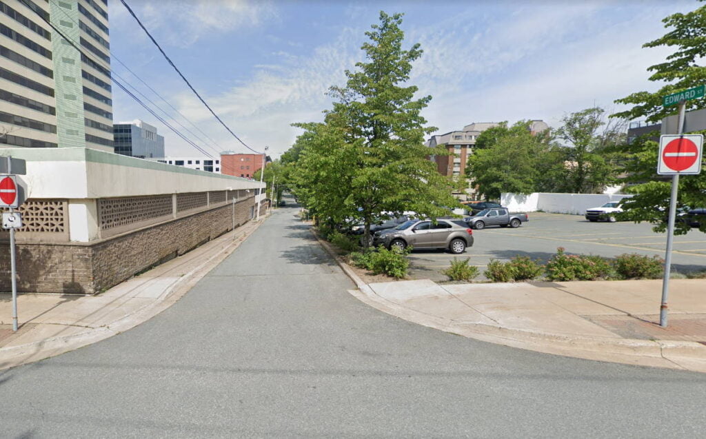
This is “Chapel Lane”, Edward Street from Queen to Ochterloney, relic of Dartmouth’s original (55 foot) street widths (Although Victoria Road, Whebby Terrace, and parts of North Street, all just outside the original town plot might also qualify). There were so many random ROWs in Dartmouth even in the 80s — between Victoria and Pine mid-block, between Wentworth and King in behind the ridge, many if not most of these have been reclaimed by adjoining property owners since, but perhaps were vestiges of escheatment too.
See also:

“Since 1749 Nova Scotia has been governed by:
“A Mr. Stokes was employed by the merchants of Milford in England, to persuade the Nantucket settlers to remove (to Milford in England): the offers were too liberal to be rejected, and the Province lost these orderly and industrious people, except Seth Coleman’s family, whose great and disinterested exertions in behalf of the poor, have secured him the favorable opinion of all men, whose approbation is valuable.
The lands behind Dartmouth, are increasing in population and agricultural improvement, which as had some effect in recovering the town. It is contemplated to open a communication by Canals, connecting the Shubenacadie with the harbor at Dartmouth: this is evidently practicable; but it is questionable, if the country be sufficiently populous, to justify so expensive a labour.”
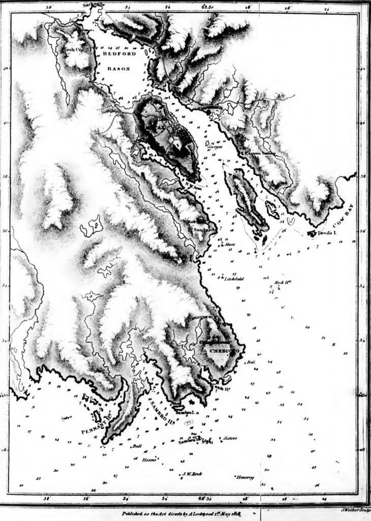

Lockwood, A. “A brief description of Nova Scotia with plates of the principal harbors : including a particular account of the Island of Grand Manan” London : Printed for the author by G. Hayden …, and sold by Cadell and Davies …, 1818. https://www.canadiana.ca/view/oocihm.46886
“An early chart of the Halifax estuary from: A brief description of Nova Scotia with Plates of the Principal Harbours including a particular account of the Island of Grand Manan”, 1 May 1818. https://archives.novascotia.ca/maps/archives/?ID=361