
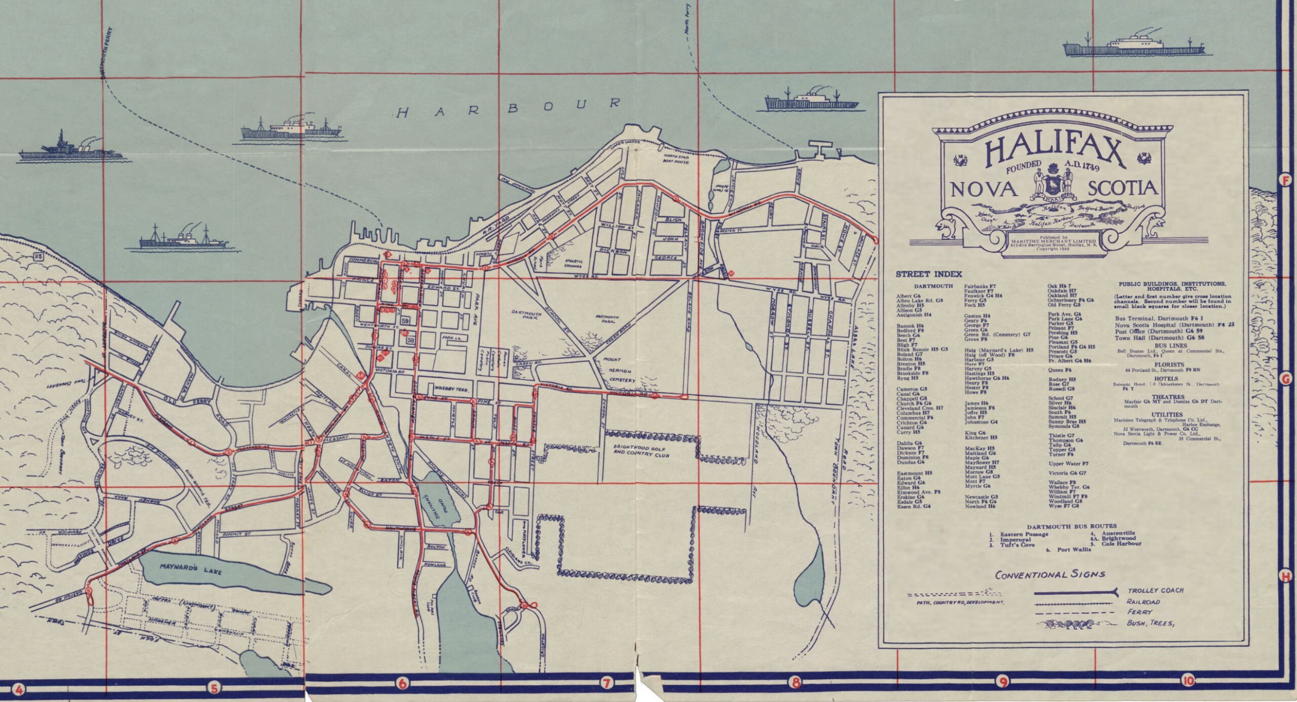
A noteworthy map since it shows Dartmouth Bus routes, seven of them (#1 Eastern Passage, #2 Imperoyal, #3 Tuft’s Cove, #4 Austenville, #4A Brightwood, #5 Cole Harbour, #6 Port Wallace); operated by Bell Bus Lines at the time.
Among the public buildings, institutions, hospitals etc. noted in Dartmouth: (“Letter and first number give cross location channels. Second number will be found in small black squares for closer location“)
Bus Terminal, Bell Busses Ltd., Queen at Commercial Streets (F6 I), Nova Scotia Hospital (F4 23), Post Office (G6 59), Town Hall (G6 58).
Florist: 64 Portland Street (F8 RN), Hotels: Belmont Hotel, 7-9 Ochterloney Street (F6 MT), Theatres: Mayfair (G6 MT) and Dundas (G6 DT), Utilities: Maritime Telegraph & Telephone Co. Ltd., Harbor Exchange, 32 Wentworth Street (G6 CC), Nova Scotia Light & Power Co. Ltd., 35 Commercial Street (F6 EE)
Street Index:
Albert (G6), Albro Lake Rd. (G8), Allenby (H5), Allison (G5), Antigonish (H4)
Banook (H6), Bedford (F8), Beech (G6), Best (F7), Bligh (F7), Blink Bonnie (H5, G5), Boland (G7), Bolton (H6), Brenton (H5), Brodie (F8), Brookisde (F8), Byng (H5)
Cameron (G5), Canal (G6), Chappell (G8), Church (F6, G6), Cleveland Cres. (H7), Columbus (H7), Commercial (F6), Chrichton (G6), Cunard (G6), Curry (H5)
Dahlia (G6), Dawson (F7), Dickson (F7), Dominion (F8), Dundas (G6)
Eastmount (H5), Eaton (G6), Edward (G6), Elliot (H6), Elmwood Ave (F8), Erskine (G6), Esdale (sic) (G5), Essen Rd. (G4)
Fairbanks (F7), Faulkner (F7), Fenwick (G4, H4), Ferry (G5), Foch (H5)
Gaston (H4), Geary (F6), George (F7), Green (G6), Green Rd. (Cemetery) (G7), Grove (F8)
Haig (Maynard’s Lake) (H5), Haig (off Wood) (F8), Harbour (G5), Hare (F7), Harvey (G5), Hastings (H5), Hawthorne (G6, H6), Henry (F8), Hester (F8), Howe (F8)
James (H6), Jamieson (F8), Joffre (H5), John (F7), Johnstone (G4)
King (G6), Kitchener (H5)
MacKay (H5), Maitland (G6), Maple (G6), Mayflower (H7), Maynard (H5), Morrow (G8), Mott Lane (G5), Mott (F7), Myrtle (G6)
Newcastle (G5), North (F6, G6), Nowland (H6)
Oak (H6, H7), Oakdale (H7), Oakland (H7), Ochterloney (F6, G6), Old Ferry (G5)
Park Ave. (G6), Park Lane (G6), Parker (G5), Pelzant (F7), Pershing (H5), Pine (G6), Pleasant (G5), Portland (F6, G6, H5), Prescott (G5), Prince (G6), Pr. Albert (G6, H6)
Queen (F6)
Rodney (H5), Rose (G7), Russell (G8)
School (G7), Silver (H6), Sinclair (H6), South (F6), Summit (H5), Sunny Brae (H5), Symonds (G8)
Thistle (G7), Thompson (G6), Tulip (G6), Tupper (G5), Turner (F6)
Upper Water (F7)
Victoria (G6, G7)
Wallace (F8), Whebby Ter. (G6), William (F7), Windmill (F7, F8), Woodland (G8), Wyse (F7, G8)
“The Only Authentic Map of the City of Halifax and Town of Dartmouth, NS”, Maritime Merchant Ltd, 1949. https://archives.novascotia.ca/maps/archives/?ID=1569&Page=202012442