Chronological Table of Dartmouth, Preston, and Lawrencetown

dartmouth township

Between 1746 and 1894, Dartmouth’s history unfolds with significant events including the arrival of settlers, establishment of saw-mills, and conflicts with the Mi’kmaq people. Dartmouth saw fluctuations in population, the building of churches and other infrastructure, and incorporation as a town in 1873. Economic activities like shipbuilding, ferry services, and the discovery of gold at Waverley mark periods of prosperity. However, tragedies such as fires, mysterious disappearances, and drowning incidents also punctuate Dartmouth’s timeline.

The town experienced advancements such as the introduction of steamboats, electricity, and the establishment of amenities like bathing houses and public reading rooms. Infrastructure projects like railway construction, water supply, and sewerage systems reflect efforts to modernize Dartmouth. Despite setbacks like bridge collapses and refinery closures, the town continued to evolve and grow, reaching a population of over 6,000 by 1891.


1746-1799

  • Duc d’Anville arrived at Chebucto, 10 Sept 1746
  • Halifax founded, 21 June 1749
  • [Mi’kmaq] attacked 6 men at Maj. Gilman’s saw-mill, Dartmouth Cove, killing 4, 30 Sept 1749
  • Saw-mill let to Capt. Wm. Clapham, 1750
  • Alderney arrived from Europe with 353 settlers, Aug. 1750
  • Town of Dartmouth laid out for the Alderney emigrants, Autumn 1750
  • Order issued relative to guard at Dartmouth, 31 Dec. 1750
  • Sergeant and 10 or 12 men ordered to mount guard during the nights at the Blockhouse, Dartmouth, 23 Feb. 1751
  • [Mi’kmaq] attacked Dartmouth, killing a number of the inhabitants, 13 May, 1751
  • German emigrants arrived at Halifax and were employed in picketing the back of Dartmouth, July 1751
  • Ferry established between Dartmouth and Halifax, John Connor, ferryman, 3 Feb. 1752
  • Mill at Dartmouth sold to Maj. Ezekiel Gilman, June 1752
  • Population of Dartmouth 193, or 53 families, July 1752
  • Advertisement ordered for the alteration of the style [Introduction of the Gregorian calendar], 31 Aug. 1752
  • Permission given Connor to assign ferry to Henry Wynne and William Manthorne, 22 Dec 1752
  • Township of Lawrencetown granted to 20 proprietors, 10 June 1754
  • Fort Clarence built, 1754
  • John Rock appointed ferryman in place of Wynne and Manthorne, 26 Jan. 1756
  • Troops withdrawn from Lawrencetown by order dated, 25 Aug, 1757
  • Dartmouth contained only 2 families, 9 Jan 1762
  • Phillip Westphal (afterwards Admiral), born, 1782
  • Preston Township granted to Theophilus Chamberlain and 163 others, chiefly loyalists, 15 Oct, 1784
  • Free [black people] arrived at Halifax and afterwards settled at Preston, Apr., 1785
  • George Augustus Westphal (afterwards Sir) born, 1785
  • Whalers from Nantucket arrived at Halifax, 1785
  • Town lots of Dartmouth escheated [See also] in order to grant them to the Nantucket whalers (Quakers), 2 Mar, 1786
  • Grant of land at Preston to T. Young and 34 others, 20 Dec. 1787
  • Common granted to inhabitants of Dartmouth [District, aka Township], 4 Sept. 1788 [Oct 2, 1758?] [–see also: “For regulating the Dartmouth Common, 1841 c52“]
  • First church at Preston consecrated (on “Church Hill”), 1791
  • Free [black people] departed for Sierra Leone, 15 Jan, 1792
  • Nantucket Whalers left Dartmouth, 1792
  • Francis Green built house (afterwards “Maroon Hall”) near Preston, 1792
  • Dartmouth, Preston, Lawrencetown and Cole Harbour erected into parish of St. John, Nov. 22, 1792
  • M. Danesville, governor of St. Pierre, arrived at Halifax (afterwards lived at “Brook House”), 20 June 1793
  • Act passed to build bridge of boats across the Harbour (1796, c7), 1796
  • Maroons arrived at Halifax (afterwards settled at Preston), 22 or 23 July, 1796
  • Subject of a canal between Minas Basin and Halifax Harbour brought before the legislature, 1797
  • Col. W.D. Quarrell returned to Jamaica, Spring 1797
  • Capt. A. Howe took charge of Maroons, Ochterloney having been removed, 1797
  • John Skerry began running ferry, about 1797
  • Howe removed and T. Chamberlain appointed to superintend Maroons, 9 July, 1798
  • Heavy storm did much damage, 25 Sept, 1798
  • Mary Russell killed by her lover, Thomas Bembridge, at her father’s house, Russell’s Lake, 27 Sept. 1798
  • Bembridge executed at Halifax, 18 Oct, 1798

1800-1849

  • Maroons left Halifax, Aug 1800
  • “Maroon Hall” sold to Samuel Hart, 8 Oct, 1801
  • Town of Dartmouth said to have contained only 19 dwellings, 1809
  • S. Hart died at “Maroon Hall” (property afterwards sold to John Prescott), 1810
  • United States prisoners of war on parole at Dartmouth, Preston, etc. About 1812-1814
  • Terrible gale, much damage to shipping 12 Nov 1813
  • Gov Danseville left “Brook House”, 1814
  • [Black people] arrived from Chesapeake Bay, 1 Sept 1814
  • Smallpox appeared in Dartmouth, Preston, etc., Autumn, 1814
  • Margaret Floyer died at “Brook House”, 9 Dec 1814
  • Act passed to incorporate Halifax Steamboat Co., 1815
  • Act passed allowing substitution of team-boats for steamboats by the company just mentioned, 1816
  • Team-boat Sherbrooke launched, 30 Sept, 1816
  • The team-boat made its first trip, 8 Nov., 1816
  • Foundation stone of Christ Church laid, 9 July, 1817
  • John Prescott died at “Maroon Hall” (property afterwards sold to Lieut. Katzmann), 1821
  • Ninety Chesapeake Bay [black people] sent to Trinidad, 1821
  • Dartmouth Fire Engine Co. established, 1822
  • Lyle’s and Chapel’s shipyards opened, About 1823
  • Act passed to authorize incorporation of a canal company, 1824
  • Theophilus Chamberlain died, 20 July, 1824
  • Joseph Findlay became lessee of Creighton’s ferry, About 1824
  • Shubenacadie Canal Co. incorporated by letters patent, 1 June, 1826
  • Ground first broken on canal, at Port Wallace, 25 July, 1826
  • Consecration of church at Preston which had been built to replace the one consecrated in 1791, 1828
  • Congregation of Church of St. James (Presbyterian) formed, Jan (?), 1829
  • St. Peter’s Chapel commenced at Dartmouth, 26 Oct. 1829
  • J. Findlay succeeded by Thos. Brewer at Creighton’s Ferry, About 1829-30
  • Sir C. Ogle launched (first steamboat on ferry), 1 Jan, 1830
  • Sixteen persons drowned by the upsetting of one of the small ferry boats, 14 Aug, 1831
  • Ferry steamboat Boxer launched, 1832
  • Brewer retired, and Creighton’s or the lower ferry ceased to exist, About 1832-33
  • A. Shiels started Ellenvale Carding Mill, July, 1834
  • Cholera in Halifax, Aug to Oct 1834
  • William Foster built an ice-house near the lakes, 1836
  • “Mount Amelia” built by Hon. J.W. Johnston, About, 1840
  • Death of Meagher children, Jane Elizabeth, and Margaret, in woods near Preston (bodies found 17 April), April 1842
  • Adam Laidlaw began ice-cutting on a large scale, 1843
  • Dartmouth Baptist Church organized, 29 Oct, 1843
  • Death of Lieut. C. C. Katzmann at “Maroon Hall”, 15 Dec, 1843
  • Ferry steamboat Micmac build, 1844
  • Dartmouth Baptist meeting-house opened, Sept, 1844
  • Cole Harbour Dyke Co. incorporated, 28 Mar., 1845
  • Incorporation of Richmond Bridge Co. (J.E. Starr, A.W. Godfrey, etc.) for purpose of erecting bridge of boards across Harbour, 14 April, 1845
  • Mechanics’ Institute building erected, 1845
  • Col. G. F. Thompson’s wife, said to have been a cousin of the Empress Eugenie, died under suspicious circumstances at “Lake Loon”, 20 Sept., 1846
  • First regatta on Dartmouth Lake, 5 Oct, 1846
  • Dr. MacDonald mysteriously disappeared, 30 Nov, 1846
  • Mechanic’s Institute building opened, 7 Dec, 1846
  • Second church at Preston (in the “Long swamp”) destroyed by fire, June (?), 1849

1850-1894

  • Third C. of E. church built at Preston, near Salmon River, About 1850-1851
  • Subenacadie Canal sold to government of N.S. (McNab, trustee), 1851-52
  • Inland Navigation Co. incorporated, 4 April, 1853
  • Methodist Church dedicated at Dartmouth, 1853
  • Canal purchased by Inland Navigation Co., 10 June, 1854
  • Mount Hope Insane Asylum cornerstone laid, 9 June, 1856
  • “Maroon Hall” burnt, June, 1856
  • Dartmouth Rifles and Engineers organized, Spring 1860
  • Checbucto Marine Railway Co. formed by A. Pillsbury, 1860
  • Gold discovered at Waverley, 1861
  • Lake and River Navigation Co. purchased Canal, 18 June, 1862
  • Dartmouth Rifles disbanded, 1 July, 1864
  • Dartmouth Axe and Ladder Co,. formed, 1865
  • Dartmouth Ropewalk began manufacturing, Spring, 1869
  • Ferry steamboat Chebucto built, About 1869
  • Prince Arthur’s Park Co. incorporated, 1870
  • New St. James’s Church (Presbyterian) built, 1870
  • Lewis P. Fairbanks purchased the canal from the Lake and River Navigation Co., Feb, 1870
  • Population of town of Dartmouth, 3,786, 1871
  • Dartmouth incorporated, 30 April, 1873
  • Union Protection Co. organized, 1876
  • Andrew Shiels, “Albyn”, died, 5 Nov, 1879
  • New Baptist Church opened, 4 Jan, 1880
  • Sandy Cove bathing houses opened at Dartmouth, 7 Aug, 1880
  • Foundation-stone of Woodside Refinery laid, 3 July, 1883
  • Railway to Dartmouth commenced, 1885
  • Railway opened for business, 6 Jan, 1886
  • Halifax and Dartmouth Steam Ferry Co. formed, in place of old company, 1886
  • Woodside Refinery closed, Dec, 1886
  • Ferry steamboat Dartmouth built, 1888
  • Public Reading-Room opened, 1 Jan, 1889
  • Dartmouth Ferry Commission formed, 17 April, 1890
  • Ferry Co. sells its property to the commission, 1 July, 1890
  • Several persons drowned on the arrival of the ferry-boat Annex 2 (Halifax), 11 July, 1890
  • New St. Peter’s Chapel begun, Autumn, 1890
  • Act passed to provide for supplying Dartmouth with water and sewerage, 19 May, 1891
  • Narrows railway bridge carried away, 7 Sept., 1891
  • Trenching and laying the main water pipe begun, 3 Oct., 1891
  • Woodside Refinery again opened, 1891
  • Population of town of Dartmouth, 6,252, 1891
  • St. Peter’s chapel opened, 7 Feb., 1892
  • Dartmouth first lighted by electricity, 13 July, 1892
  • Water turned on the town from Topsail and Lamont’s Lakes, 2 Nov, 1892
  • Narrows bridge destroyed for second time, 23 July, 1893
  • Woodside Refinery transferred to Acadia Sugar Refining Co., Aug, 1893
  • New Post Office opened, 1 May, 1894

Piers, Harry, 1870-1940. Chronological Table of Dartmouth, Preston, And Lawrencetown, County of Halifax, Nova Scotia. Halifax, N.S.: [s.n.], 1894. https://www.canadiana.ca/view/oocihm.12013/12?r=0&s=1, https://hdl.handle.net/2027/aeu.ark:/13960/t8pc3fx9z

Dartmouth Township

dartmouth township map

A particularly clear representation of the townships in Halifax County. As an aside, the Township of Dartmouth was seemingly “lost” around the time of “confederation”, which seems to have helped to spur the push for the incorporation of the Town of Dartmouth by 1873.

What remained of the township of Dartmouth seemingly reverted to “Halifax County”, an entity “neither a corporation nor an individual capable of instituting proceedings”, according to Rigby Q.C., barrister for Dartmouth, as recently as 1880.

The success of this case at the Supreme Court of Canada is mentioned in the Town’s Annual Report of 1886: https://cityofdartmouth.ca/annual-report-1886/

Old Annapolis Road

old-annapolis-road2

After piecing together several Crown land grant maps, you can see the path of the Old Annapolis Road much more clearly. Open the image in a new tab, to see it in more detail.

Below you’ll find a few representations of the road as a contiguous route, as opposed to what is left recorded on the Crown Land Grant maps. (You can find find the individual Crown Land Grant maps here: https://novascotia.ca/natr/land/grantmap.asp)

One of the earliest road maps, from 1755, the Bay of Fundy still going by the name of Argal’s Bay. “A New map of Nova Scotia and Cape Britain”, https://gallica.bnf.fr/ark:/12148/btv1b53089581f

“Map of Nova Scotia, or Acadia, with the islands of Cape Breton and St. John’s, from actual surveys” https://gallica.bnf.fr/ark:/12148/btv1b53209890m

Previous to the construction of the more direct route to Annapolis, this map from 1776 shows a road (from Dartmouth, certainly an error, likely from Fort Sackville at the head of the harbor) to Annapolis. “A general Map of the northern British Colonies in America which comprehends the province of Quebec, the government of Newfoundland, Nova Scotia, New England and New-York” https://gallica.bnf.fr/ark:/12148/btv1b8443126p

One of the first representations of the Old Annapolis Road, “Road markt out by Gov. Parr’s orders in 1784”

nova scotia map Annapolis road

“A map of Nova Scotia showing the post roads”, 1787. https://collections.leventhalmap.org/search/commonwealth:hx11z4938

“A Map of the United States and Canada, New Scotland, New Brunswick and New Foundland”, 1806. https://gallica.bnf.fr/ark:/12148/btv1b53100560v

“Map of the Province of Nova Scotia Including Cape Breton, Prince Edwards Island and Part of New Brunswick”, 1819. https://nscc.cairnrepo.org/islandora/object/nscc%3A112, https://collections.leventhalmap.org/search/commonwealth:8049g892q

“Map of the Provinces Of New Brunswick, and Nova Scotia”, 1825. https://nscc.cairnrepo.org/islandora/object/nscc%3A715

annapolis road map 1827

“Map of the United States; and the Provinces of Upper & Lower Canada, New Brunswick, and Nova Scotia”, 1827: https://www.davidrumsey.com/luna/servlet/detail/RUMSEY~8~1~4239~340032:Map-of-the-United-States-

“The Provinces of Lower & Upper Canada, Nova Scotia, New Brunswick, Newfoundland & Prince Edward Island with a large section of the United States”, 1831. https://gallica.bnf.fr/ark:/12148/btv1b530987207

“Maps of the Society for the Diffusion of Useful Knowledge”, 1832: https://www.davidrumsey.com/luna/servlet/detail/RUMSEY~8~1~20966~530058:Nova-Scotia,-N-B-,-Lower-Canada

“North America : sheet I. Nova-Scotia with part of New Brunswick and Lower Canada”, 1832: https://digitalarchive.mcmaster.ca/islandora/object/macrepo%3A26988

“Nouvelle carte des Etats-Unis, du Haut et Bas-Canada : de la Nouv[el]le-Écosse, du Nouv[e]au-Brunswick, de Terre-Neuve”, 1832
https://gallica.bnf.fr/ark:/12148/btv1b530354369

“Map of the United States; and the Provinces of Upper & Lower Canada, New Brunswick, and Nova Scotia”, 1835: https://www.davidrumsey.com/luna/servlet/detail/RUMSEY~8~1~316476~90085094:Composite–Map-of-the-United-States

From: “The London atlas of universal geography”, 1837: https://www.davidrumsey.com/luna/servlet/detail/RUMSEY~8~1~33890~1170042:Lower-Canada

From: “British Possessions in North America, with part of the United States”, 1840: https://hdl.huntington.org/digital/collection/p15150coll4/id/9901

From: “Nelson’s new map of the British provinces in North America”, 1840–1849: https://collections.leventhalmap.org/search/commonwealth:0z709278h

From: “Lower Canada, New Brunswick, Nova Scotia, Prince Edwards Id. Newfoundland, and a large portion of the United States”, 1846. https://digitalarchive.mcmaster.ca/islandora/object/macrepo%3A31427

“Map of the provinces of Canada, New Brunswick, Nova Scotia, Newfoundland and Prince Edward Island”, 1846. https://digitalarchive.mcmaster.ca/islandora/object/macrepo%3A81413

“Lower Canada, New Brunswick, Nova Scotia, Prince Edwards Id. Newfoundland, and a large portion of the United States.”, 1853. https://hdl.huntington.org/digital/collection/p15150coll4/id/100

“Belcher’s map of the Province of Nova Scotia”, 1855: https://www.davidrumsey.com/luna/servlet/detail/RUMSEY~8~1~3016~290077:Belcher-s-map-of-the-Province-of-

“Map of the British Province of New Brunswick”, 1858: https://www.davidrumsey.com/luna/servlet/detail/RUMSEY~8~1~325278~90094243:Map-of-the-British-Province-of-New-

“The royal atlas of modern geography”, 1861: https://www.davidrumsey.com/luna/servlet/workspace/handleMediaPlayer?qvq=&trs=&mi=&lunaMediaId=RUMSEY~8~1~21338~620038

“Mackinlay’s map of the Province of Nova Scotia, including the island of Cape Breton”, 1862: https://www.davidrumsey.com/luna/servlet/detail/RUMSEY~8~1~2372~220044:Mackinlay-s-map-of-the-Province-of-

The portion of the Annapolis road that traverses Halifax County, as seen in the “Topographical township map of Halifax County” from A.F. Church and Co, 1864. https://collections.lib.uwm.edu/digital/collection/agdm/id/14722/rec/1

“Mackinlay’s map of the Province of Nova Scotia”, 1865: https://www.davidrumsey.com/luna/servlet/detail/RUMSEY~8~1~2374~220046:Mackinlay-s-map-of-the-Province-of-

“Colton’s… Nova Scotia”, 1865: https://www.davidrumsey.com/luna/servlet/detail/RUMSEY~8~1~208606~5003402:New-Brunswick,-Nova-Scotia–Prince-

“Colton’s Dominion of Canada”, 1869: https://www.davidrumsey.com/luna/servlet/detail/RUMSEY~8~1~208947~5003938:Dominion-of-Canada–Provinces-of-Ne

Annapolis Road seen here at Stoddards as it made its way through to what is now Dalhousie East. “Annapolis County part of A.F. Church Map”, 1876. https://archives.novascotia.ca/maps/archives/?ID=942

Annapolis Road pieced together from several pages of the “Atlas of the Maritime Provinces of the Dominion of Canada”, Roe Brothers, St. John, NB 1878. https://www.islandimagined.ca/roe_atlas

“Statistical & general map of Canada”, 1883: https://www.davidrumsey.com/luna/servlet/detail/RUMSEY~8~1~31463~1150419:Canada-1-

“Canada : the provinces of Quebec, Nova Scotia, New Brunswick, Prince Edward Island and Newfoundland”, 1886. https://digitalarchive.mcmaster.ca/islandora/object/macrepo%3A27057

“Mackinlay’s map of the Province of Nova Scotia”, 1890: https://www.davidrumsey.com/luna/servlet/detail/RUMSEY~8~1~3012~220131:Mackinlay-s-map-of-the-Province-of-

“Stanford’s London atlas of universal geography”, 1904: https://www.davidrumsey.com/luna/servlet/detail/RUMSEY~8~1~314730~90083550:Quebec,-New-Brunswick,-Nova-Scotia

“Dominion of Canada : E. Quebec, New Brunswick, Nova Scotia, Prince Edward Id. and Newfoundland”, 1910. https://collections.library.yale.edu/catalog/15827305

One of the last representations of the Old Annapolis Road:

Mackinlay’s map of the Province of Nova Scotia Compiled from Actual & Recent Surveys, 1912: https://nscc.cairnrepo.org/islandora/object/nscc%3A534

Fifteen years later, by 1927, the Old Annapolis Road disappears from the maps. Perhaps it wasn’t fit for automobile travel, though it’s hard not to notice the change (back?) to “Annapolis Royal” from “Annapolis” occurred at the same time.

From: “Rand McNally auto road atlas of the United States and Ontario, Quebec, and the Maritime Provinces of Canada”, 1927: https://www.davidrumsey.com/luna/servlet/detail/RUMSEY~8~1~33775~1171491:Maritime-Provinces-

Much of the road is now incorporated into other routes. It’s the #8 from Annapolis through Lequille, it’s the West Dalhousie Road through to Lake La Rose and from West Dalhousie to Albany Cross on to Stoddard’s where it once continued straight at what is now a turn (see above at 1876). It then crossed over the brook that empties into Upper Thirty Lake, from there it continued across another bridge, this time over the LaHave River to connect to what is now Camel Hill Road. The route proceeded to where it now meets Cherryfield Road and becomes Dalhousie Road, and on eastwards from there, through to Franey Corner and on to New Ross. At this point the route seems to have been reclaimed by the woods somewhat but it continued south and east near Sherwood, and then north of Canaan and Timber Lake, to the south of Panuke Lake (once called “Carrying Place”, see above at 1864) near Simms Settlement, through the country between Sandy and Rafter lake then terminating at Pockwock Road, north of Wrights Lake in Upper Hammonds Plains.

From: “Halifax & Dartmouth City & Maritimes map”, 1976. https://archives.novascotia.ca/maps/archives/?ID=948&Page=202012493

See also:

Body politic, Body corporate ⁠— City limits

dartmouth city limits

An examination of the legislated spatial dimensions of Dartmouth – from its initial definition as a township care of the Royal instructions that accompanied Cornwallis in 1749 to its dissolution in one of Nova Scotia’s city county mergers by fiat (aka a “municipal coup”) in 1996.

“And whereas for the better security, regulation and government of our said settlement, it will be necessary that such persons as we shall judge proper to send to our said province should be settled in townships; you are therefore hereby authorized and required to appoint such proper persons as you shall find there fully qualified to carry along with you forthwith to survey and mark out the said townships in such manner and at such places as is herein directed, that is to say, two townships containing 100,000 acres of land each be marked out at or near our harbor of Chebucto, as also one township of the like extent at each of the aforementioned places or such others as you shall judge most proper; and you are to take particular care in laying out such townships that they do include the best and most profitable land and also that they do include the best and most profitable rivers as may be at or near the said settlements and that the said townships do extend as far up into the country as conveniently may be, taking in a necessary part of the seacoast”.

769: Laying out townships in Nova Scotia (I). 1749-1752; (§§ 770, 766).
Labaree, Leonard Woods. “Royal Instructions To British Colonial Governors”, Volume II. New York, Octagon Books, 1967.
https://archive.org/details/royalinstruction028364mbp/page/n93/mode/2up

 “the Town and Suburbs of Dartmouth”

An Act for Establishing and Regulating a Militia, Law by Proclamation, by Command of his Excellency the Governor and his Majesty’s Council, May 10, 1753.

“That the Township of Dartmouth comprehend all the Lands lying on the East Side of the Harbour of Halifax and Bedford Basin, and extending and bounded Easterly by the Grant to the Proprietors of Lawrence-Town, and extending from the North-easterly Head of Bedford Basin into the Country, until One Hundred Thousand Acres be comprehended.”

Proclamation of His Excellency Charles Lawrence, with the Advice and Consent of His Majesty’s Council, January 3rd 1757. Journals of the Board of Trade and Plantations; Townships, Elections, 1757. Proclamation, Governor Charles Lawrence – official announcement and details about the election of representatives to the new General Assembly. The National Archives of the UK (TNA) . Colonial Office and Predecessors: Nova Scotia and Cape Breton Original Correspondence. CO 21/16 ff. 154

“the inhabitants of the town plot of Dartmouth…in said town…the district of Dartmouth”

Chapter 6 of the Acts of 1789, “An act to enable the Inhabitants of the Town Plot of Dartmouth to use and occupy the Common Field, granted them by his excellency the Lieutenant-Governor, in such way as they may think most beneficial to them”
http://0-nsleg–edeposit.gov.ns.ca.legcat.gov.ns.ca/deposit/Statutes/at_large/volume1/1789.pdf

“Common of the town of Dartmouth…the common of the township of Dartmouth; situate on the eastern side of the harbour of Halifax, in special trust, for the use of the inhabitants settled and resident in the town plot, or that might thereafter settle, and actually reside, within the township of Dartmouth… Within the township of Dartmouth”

Chapter 2 of the Acts of 1797, “An act to enable the Governor, Lieutenant Governor, or Commander in chief for the time being, to appoint Trustees, for the Common of the Town of Dartmouth, on the death, or removal, of the Trustees holding the same, and to vacate that part of the grant of the Common aforesaid, which vests trust in the heirs, executors or administrators, of the Trustees, named in the said grant, on the death of such Trustees”
http://0-nsleg–edeposit.gov.ns.ca.legcat.gov.ns.ca/deposit/Statutes/at_large/volume1/1797.pdf

“Town plot of Dartmouth… The said town… The town plot of Dartmouth, bounded on the North by the Common, on the South and West by the Halifax Harbour, and on the east by Mill Brook… Of the said towns respectively, within the said limits.”

Chapter 23 of the Acts of 1818, “An act to extend the provisions of c15 of 1761 relating to Trespasses, to the Town of Pictou and the Town Plot of Dartmouth”
https://0-nsleg–edeposit-gov-ns-ca.legcat.gov.ns.ca/deposit/Statutes/at_large/volume3/1818.pdf

“The town of Dartmouth”

Chapter 32 of the Acts of 1820-21 “To extend the Act for appointing Firewards to the Town of Dartmouth”
https://0-nsleg–edeposit-gov-ns-ca.legcat.gov.ns.ca/deposit/Statutes/at_large/volume3/1820-21.pdf

“the Town of Dartmouth… inhabitants of the said town… the jurisdiction, powers and authority, of the commissioners so to be appointed for the said Town of Dartmouth, shall be confined and restricted to the bounds and limits following, that is to say:⁠— to the direction or space of one Mile, measured in a southwardly, Easterly, and Northerly direction, from the Public Landing, or Steam Boat Company Wharf, in the said Town.”

Chapter 27 of the Acts of 1828 “To extend the Act relating to Commissioners of Highways to the Town of Dartmouth” https://0-nsleg–edeposit-gov-ns-ca.legcat.gov.ns.ca/deposit/Statutes/at_large/volume3/1828.pdf
A rough idea of what a 1 mile radius from the Ferry terminal wharf looks like.

“Inhabitants resident in the Town Plot of Dartmouth, at a meeting to be called for that purpose… Annual Meeting of the said Inhabitants”

Chapter 52 of the Acts of 1841, “An Act for regulating the Dartmouth Common” http://0-nsleg–edeposit.gov.ns.ca.legcat.gov.ns.ca/deposit/Statutes/1841.pdf

“the Town of Dartmouth, in the County of Halifax… the said Town of Dartmouth”

Chapter 48 of the Acts of 1843, “An Act to extend to the Town of Dartmouth the Act to amend the Act to regulate the Assize of Bread” http://0-nsleg–edeposit.gov.ns.ca.legcat.gov.ns.ca/deposit/Statutes/1843.pdf

“Whereas some uncertainty exists as regards the limits of the Township of Dartmouth… Be it therefore enacted by the Lieutenant Governor, Council and Assembly, that the lines of the Township of Dartmouth shall be established and settled as follows, beginning on the Eastern side of Bedford Basin at the head of Pace’s cove at low water mark, and thence to run north seventy four degrees east until it meets the main stream running Into Lake Major, thence southerly through the center of Lake Major and West Salmon River to the waters of Cole Harbor and thence Southwestwardly along the shore the several courses of the shore to Roaring Point, thence northerly following the course of the shore of the Main Land at low water mark to the place of beginning, so as not to include any Islands lying on or near said shore.

Chapter 17 of the Acts of 1846, “An Act to define and establish the Lines of the Township of Dartmouth”
https://0-nsleg–edeposit-gov-ns-ca.legcat.gov.ns.ca/deposit/Statutes/1846.pdf

“…the inhabitants of the said town of Dartmouth …within the space of one mile, measured in a southwardly, easterly and northerly direction from the public landing or Steamboat Company’s wharf in said town”

Chapter 29 of the Acts of 1847, “In relation to Assessment for a Fire Engine at Dartmouth”
https://0-nsleg–edeposit-gov-ns-ca.legcat.gov.ns.ca/deposit/Statutes/1847.pdf

For Dartmouth…one mile, measured in a southwardly, easterly and northerly direction from the public landing or Steamboat Company’s wharf in the said Town”

Chapter 46 of the Acts of 1847, “An act relating to Streets and Highways … in the Town of Dartmouth”
https://0-nsleg–edeposit-gov-ns-ca.legcat.gov.ns.ca/deposit/Statutes/1847.pdf

“After the first Annual Town Meeting in the Township of Dartmouth, Three Trustees of Public Property shall be chosen, in whom shall be vested the legal possession of the several Water Lots that have been reserved for the use of the Public along the shores of the Town Plot of Dartmouth, and of a certain Lot of Land and School House now known and distinguished as the School Lot, lying in the Town Plot, to be recovered, held and preserved by the Trustees for the uses to which the same respectively have been reserved and applied, but the School House and School Lot shall be preserved exclusively to the use of Schools and Education, and nothing herein shall excuse the possession and control of the Trustees to be appointed under the Act passed in the present Session for the support of Schools if the School House and Lot might otherwise come under control of such Trustees. Any other Public Property in the Township of Dartmouth not legally possessed by or under the charge and supervision of any person, shall also be legally vested in the Trustees appointed under this act… three trustees shall be annually thereafter appointed at each Annual Town Meeting of the Township… The Inhabitants, in Town Meeting, at any time may declare the purposes to which the Town Property shall be applied by the Trustees, provided those purposes shall not be inconsistent with the uses to which the property has been granted, reserved or legally appropriated… the next Annual Town Meeting of Dartmouth”

Chapter 53 of the Acts of 1850, “An Act Concerning Town Property in Dartmouth” http://0-nsleg–edeposit.gov.ns.ca.legcat.gov.ns.ca/deposit/Statutes/1850.pdf

“The rateable inhabitants residing within the town plot of the township of Dartmouth, in the county of Halifax, may assess themselves, at any public meeting… for the purpose of obtaining a good and sufficient plan of said town plot… the inhabitants of the said town plot… The Commissioner of Streets for the said township…”

Chapter 56 of the Acts of 1866, “To authorize an assessment on the inhabitants of the Town Plot of Dartmouth”
https://0-nsleg–edeposit-gov-ns-ca.legcat.gov.ns.ca/deposit/Statutes/1866.pdf

“The Trustees of the Dartmouth Common shall be a Body politic and corporate… the Commissioner of Streets for the Town of Dartmouth… A requisition signed by two thirds at least of the rate payers residing within the limits of the town plot of Dartmouth… Which town plot shall be construed to embrace an area within a distance of one mile measured in a southwardly, easterly and northerly direction from the public landing or Steamboat Company’s wharf in said town”

Chapter 31 of the Acts of 1868, “To amend the several Acts relating to the Dartmouth Common”
https://0-nsleg–edeposit-gov-ns-ca.legcat.gov.ns.ca/deposit/Statutes/1868.pdf

‘A municipality shall be erected within the County of Halifax, to be bounded as follows, that is to say: Beginning on the eastern side of the Harbor of Halifax, at a point in such Harbor distant three hundred feet Westerly from the South Western corner of a lot of land formerly owned by Judge Johnston and by him conveyed to John Esdaile; thence to run Eastwardly till it strikes the road leading to the property of the late John Esson; thence by the Southern side of such road and following the course thereof Eastwardly to such Esson property; thence along the Western boundary of such property, Southwardly to the South-Western corner thereof; thence Eastwardly to Gaston’s Road, and crossing such road to a point at right angles with the extension of a new road laid out by J.W. Watt through manor Hill Farm; thence Northwardly to such road and by such road for the length thereof; thence Northwardly to the causeway at Hurley’s on the First Lake; thence Northwardly to the North East boundary of Stair’s Ropewalk property; thence Westwardly to a point three hundred feet into the Harbor of Halifax; and thence Southwardly to then place of beginning; to be called and known as “The Town of Dartmouth”‘.

Chapter 17 of the Acts of 1873, “An Act to Incorporate the Town of Dartmouth” https://0-nsleg–edeposit-gov-ns-ca.legcat.gov.ns.ca/deposit/Statutes/1873.pdf

The inhabitants of the town of Dartmouth are constituted and declared to be a body corporate and politic by the name of the Town of Dartmouth. They shall as a corporation have perpetual succession and a Common Seal, changeable at pleasure, and shall be capable of suing and being sued in all Courts of Justice, and of acquiring, holding and conveying any description of property, real, personal or mixed, and shall have all the other rights usually had and enjoyed by corporations.

The Town of Dartmouth shall be bounded as follows:⁠—

Beginning on the eastern side of the Harbor of Halifax, at a point in such Harbor distant three hundred feet Westerly from the South Western corner of a lot of land formerly owned by Judge Johnston and by him conveyed to John Esdaile; thence to run Eastwardly till it strikes the road leading to the property of the late John Esson; thence by centre of such road and following the course thereof Eastwardly to such Esson property; thence along the Western boundary of such property, Southwardly to the South-Western corner thereof; thence Eastwardly to Gaston’s Road, and crossing such road to a point at right angles with the extension of a new road laid out by J.W. Watt through manor Hill Farm; thence Northwardly to such road and by such road for the length thereof; thence Northwardly to the western extremity of the causeway at Hurley’s on the First Lake; thence Northwestardly through Taylor’s barn on the opposite side of the lake until it strikes the Southern side line of the road which connects with the new road laid out by G. A. S Chichton, thence following the southern line of said road until it reaches the main road leading from Dartmouth to Bedford; and from thence crossing said road in a straight line following the said line of the said new road until it extends three hundred feet into the harbor of Halifax, and thence Southwardly to the place of beginning to be called and known as “The Town of Dartmouth”.

Chapter 40 of the Acts of 1877, “An Act to amend the Act entitled, “An Act to Incorporate the Town of Dartmouth” https://0-nsleg–edeposit-gov-ns-ca.legcat.gov.ns.ca/deposit/Statutes/1873.pdf

“The inhabitants of the town of Dartmouth are constituted and declared to be a body corporate and politic by the name of the Town of Dartmouth, and the boundaries of the town of Dartmouth, the division of the same into wards, and the boundaries of the several wards thereof, shall continue as at the passing of this Act.”

Chapter 86 of the acts of 1886, “An Act to Amend the Acts relating to the Town of Dartmouth”

[Included is a copy of the 1886 Statues from archive.org, since the copy supplied by the Government of Nova Scotia is missing page 253, which just so happens to be paragraph 1-3 of this Act to Amend the Acts relating to the Town of Dartmouth, which contains the above quoted passage, along with an explicit mention of male or female ratepayers, residents and nonresidents as qualified to vote.]

https://archive.org/embed/statutesnovasco01scotgoog
http://0-nsleg–edeposit.gov.ns.ca.legcat.gov.ns.ca/deposit/Statutes/1886.pdf

‘The body so constituted shall be a body corporate, under the name of “The Dartmouth Ferry Commission…”‘

Chapter 83 of the Acts of 1890, “An Act to provide for the establishment and operation of a Public Ferry between Dartmouth and Halifax”
https://0-nsleg–edeposit-gov-ns-ca.legcat.gov.ns.ca/deposit/Statutes/1890.pdf

“The Dartmouth Ferry Commission shall continue to be a body politic and corporate, as constituted under chapter 83 of the Acts of 1890 and amending Acts.”

Chapter 37 of the Acts of 1894, “An Act to Consolidate the Acts relating to the establishment and operation of a Public Ferry between Dartmouth and Halifax”, https://0-nsleg–edeposit-gov-ns-ca.legcat.gov.ns.ca/deposit/Statutes/1894.pdf

“The assessors shall also insert on the roll the names of all yearly tenants in occupation of real property assessed.”

Chapter 65 of the Acts of 1901, “Act to amend Chapter 50 of the Acts 1897, amending Towns’ Incorporation Act so far as relates to Dartmouth”
https://0-nsleg–edeposit-gov-ns-ca.legcat.gov.ns.ca/deposit/Statutes/1901.pdf

The town of Dartmouth is bounded as follows:

Beginning at a point in the harbor of Halifax distant three hundred feet westerly from the southwestern corner of a lot of land formerly owned by the late Judge Johnstone, and by him conveyed to John Esdaile; thence eastwardly to the road leading to the property of the late John Esson; thence by the centre of such road and following the course thereof eastwardly to such Esson property; thence along the Western boundary of such property southwardly to the southwestern corner thereof; thence eastwardly to the eastern side of Gaston’s Road; thence in a straight line to the point of intersection of the eastern side line of a new road laid out by J. W. Watt through Manor Hill farm, and the northern side line of Cole Harbor Road; thence northwardly by the said new road for the length thereof; thence northwardly to the western extremity of the causeway at Hurley’s on the first lake; thence northwestwardly through Taylor’s born on the opposite side of the lake until it strikes the southern line of the road which connects with the new road laid out by G. A. S. Chrichton; thence following the southern side of said road until it reaches the main road leading from Dartmouth to Bedford, and from thence crossing said road in a straight line following the said line of the said new road until it extends three hundred feet into the harbor of Halifax; thence southwardly in a line parallel to the shore of the harbor, and distant three hundred feet therefrom to the place of beginning. (1873, c. 17, s. 1; 1877, c. 40; 1897, c. 50, s. 3)

Chapter 56 of the Acts of 1902, “An Act to Consolidate the Acts Relating to the Town of Dartmouth
https://0-nsleg–edeposit-gov-ns-ca.legcat.gov.ns.ca/deposit/Statutes/1902.pdf

The Town of Dartmouth is bounded as follows:

Beginning at the point of intersection of ordinary high water mark on the eastern shore of Halifax Harbor with the prolongation south-westerly of the centre line of a stone wall defining the south-eastern boundary of a lot of land formerly owned by the late Judge Johnstone and by him conveyed to John Esdaile; thence north-easterly along said prolongation and the centre line of said stone wall 1084 feet to a monument on the eastern line of Pleasant Street; thence 52 degrees 22 minutes right, 880.9 feet to a monument; thence 38 degrees 24 minutes left, 826.8 feet to a monument on the south western boundary of the Esson farm; thence 76 degrees 48 minutes right along the southwestern boundary of said Esson Farm 1097.5 feet to a monument; thence 89 degrees 49 minutes left 1799 feet to a monument on the southeastern boundary of the Dartmouth Rod and Gun club; thence 86 degrees 50 minutes left along the rear line of properties situated on the southern side of Gaston Road, and crossing Gaston Road 1322.4 feet to a monument in rear of Atwood’s house on Gaston Road; thence 10 degrees 22 minutes right crossing Cole Harbor Road and along the eastern side of Watt Street 2411.2 feet to a monument on the southern line of Maynard Street; thence 11 degrees 7 minutes right crossing Oat Hill Lake, 2628 feet to a monument on the southwestern corner of the causeway on the Preston or Lake Road near Robert Carter’s; thence 13 degrees 32 minutes left, crossing Banook Lake 4757 feet to a monument on the southwestern corner of Crichton Avenue and Albro Lake Road; thence 10 degrees 19 minutes left along the southwestern side of Albro Lake Road 1085.8 feet to a monument; thence 88 degrees 25 minutes left along the south-eastern side of Albro Lake Road 2061.6 feet to a monument; thence 42 degrees 40 minutes right along the southern side of Albro Lake Road 400 feet to a monument; thence 19 degrees along the south side of Albro Lake Road 841 feet to a monument; thence 26 degrees 27 minutes left along the southeastern side of Albro Lake Road 1328.5 feet to a monument on the eastern line of Wyse Road at the point of intersection with the prolongation easterly of the northern side of the stone wall on the southern side of Albro Lake Road; thence 19 degrees 50 minutes right along the northern side of the stone wall on the southern side of Albro Lake Road 877.9 feet to a monument on the eastern side of Windmill Road; thence 6 degrees 30 minutes left, 1030 feet more or less to ordinary high water mark; thence in a general southerly direction along the shore of Halifax Harbor, as defined by ordinary high water mark, to the place of beginning, together will all water grants, docks, quays, slips and erections connected with the shores of the town which shall be deemed to be included in the boundaries and form part of the town.

Chapter 97 of the Acts of 1925, “An Act Relating to the Town of Dartmouth”
https://0-nsleg–edeposit-gov-ns-ca.legcat.gov.ns.ca/deposit/Statutes/1925.pdf

The Town of Dartmouth is bounded as follows:

Beginning at the point of intersection of ordinary high water mark on the eastern shore of Halifax Harbor with the prolongation south-westerly of the centre line of a stone wall defining the south-eastern boundary of a lot of land formerly owned by the late Judge Johnstone and by him conveyed to John Esdaile;

Thence north-easterly along said prolongation and the centre line of said stone wall 1084 feet to a monument on the eastern line of Pleasant Street;

Thence southerly along the eastern line of Pleasant Street to the northern line of Johnstone avenue and northern line of Esson Road to the south western boundary of the “Esson farm”;

Thence southeasterly along the southwestern boundary of the “Esson Farm” 100 feet (one hundred) more or less to a monument;

Thence continuing southeasterly along the southwestern boundary of the “Esson Farm” 1097.5 feet to a monument;

Thence 89 degrees 49 minutes left 1799 feet to a monument on the southeastern boundary of the Dartmouth Rod and Gun club;

Thence 86 degrees fifty minutes left along the rear line of properties situated on the southern side of Gaston Road, and crossing Gaston Road 1322.4 feet to a monument in rear of Atwood’s house on Gaston Road;

Thence 10 degrees 22 minutes right crossing Cole Harbor Road and along the eastern side of Watt Street 2411.2 feet to a monument on the southern line of Maynard Street;

Thence 11 degrees 7 minutes right crossing Oat Hill Lake, 2628 feet to a monument on the southwestern corner of the causeway on the Preston or Lake Road near Robert Carter’s;

Thence 13 degrees 32 minutes left, crossing Banook Lake 4757 feet to a monument on the southwestern corner of Crichton Avenue and Albro Lake Road;

Thence 10 degrees 19 minutes left along the southwestern side of Albro Lake Road 1085.8 feet to a monument;

Thence 88 degrees 25 minutes left along the south-eastern side of Albro Lake Road 2061.6 feet to a monument;

Thence 42 degrees 40 minutes right along the southern side of Albro Lake Road 400 feet to a monument;

Thence 19 degrees along the south side of Albro Lake Road 841 feet to a monument;

Thence 26 degrees 27 minutes left along the southeastern side of Albro Lake Road 2700 feet to a monument;

Thence 3 degrees 43 minutes right along the southern side of Albro Lake Road 1328.5 feet to a monument on the eastern line of Wyse Road at the point of intersection with the prolongation easterly of the northern side of the stone wall on the southern side of Albro Lake Road;

Thence 19 degrees 50 minutes right along the northern side of the stone wall on the southern side of Albro Lake Road 877.9 feet to a monument on the eastern side of Windmill Road;

thence 6 degrees 30 minutes left, 1030 feet more or less to ordinary high water mark;

thence in a general southerly direction along the shore of Halifax Harbor, as defined by ordinary high water mark, to the place of beginning, together will all water grants, docks, quays, slips and erections connected with the shores of the town which shall be deemed to be included in the boundaries and form part of the town.

Chapter 60 of the Acts of 1938, “An Act Relating to the Town of Dartmouth”
https://0-nsleg–edeposit-gov-ns-ca.legcat.gov.ns.ca/deposit/Statutes/1938.pdf

The Town of Dartmouth shall continue to be a body corporate under the name “City of Dartmouth” .

The boundaries of the City are as follows:-

Beginning at a point defined by the intersection of the centre line of Wright Brook (at its mouth) with the shoreline of Wright Cove on the north-eastern shore of Bedford Basin;

Thence generally north-easterly along the centre line of Wright Brook to its intersection with the north-western boundary of the Canadian National Railways Right-of-way;

Thence generally north-easterly along the north-western boundary of the said Canadian National Railways Right-of-way to its first intersection with the centre line of McGregor Brook;

Thence generally south-easterly crossing the Canadian National Railways Right-of-way and along the centre line of McGregor Brook to its origin approximately at grid point 52.4 by east 54.7 (Department of Mines and Surveys Map, Bedford Basin, Scale 1 to 25,000) which aforesaid water course flows generally south-easterly into Lake Charles;

Thence generally south-easterly along the centre line of aforesaid Water Course to its mouth on the western shore oof Lake Charles;

Thence easterly along a straight line to the general centre of Lake Charles easterly from the mouth of the aforesaid water course;

Thence northerly along the general centre line of Lake Charles to the northern shore of Lake Charles at its junction with the centre line of the mouth of the northerly water course leading from Lake Charles to Lake William;

Thence generally northerly along the centre line of the aforesaid water course to its intersection with the southern boundary of the Nova Scotia Light and Power Company limited transmission line right-of-way;

Thence easterly along the aforesaid water course to its intersection with the southern boundary of the Nova Scotia Light and Power Company Limited transmission line right-of-way;

Thence easterly along the aforesaid southern boundary of the Nova Scotia Light and Power Company Limited transmission line right-of-way to a point on said southern boundary, which point is at the intersection of this boundary with straight line measured 1,000 feet at right angles from the north-eastern boundary of No. 18 Highway;

Thence generally south-easterly along a line parallel to and distant 1,000 feet easterly from the north-eastern boundary of No. 18 Highway to the centre line of Mitchell Brook;

Thence generally south-easterly along the centre line of said Mitchell Brook to its junction with the shore line of Loon Lake;

Thence south-easterly along the general centre line of Loon Lake to a point northerly from the centre line of the mouth of Cranberry Lake Brook at its mouth on the shore of Loon Lake;

Thence southerly to the centre line of the mouth of said Cranberry Lake Brook at the shore of Loon Lake;

Thence generally south easterly along the centre line of said Cranberry Lake Brook to its junction with the shore line of Cranberry Lake;

Thence south easterly along the general centre line of Cranberry Lake to its southern tip;

Thence south-westerly along a straight line to the northern tip of Settle Lake;

Thence southerly along the general centre line of Settle Lake to its southern shore at tis junction with the centre line of the water course flowing out of the southern tip of Settle Lake;

Thence south-easterly along the centre line of said water course to its intersection with the centre line of the Cole Harbour Road;

Thence south-westerly along a straight line to the north-western tip of Morris Lake;

Thence south-easterly along the general centre line of Morris Lake to a point north easterly from the intersection of the north western boundary of the Department of National Defense property (R.C.N.A.S., H.M.C.S. Shearwater) with the western shore of Morris Lake;

Thence south-westerly along a straight line to the said point of intersection;

Thence south-westerly by the several courses of the aforesaid north-western boundary to the shore of Eastern Passage in Halifax Harbour;

Thence south-westerly across the waters of Eastern Passage of Halifax Harbour to a point 2,000 feet off the general shoreline of the north-eastern shoreline of Halifax Harbour;

Thence north-westerly along a straight line to a point 2,000 feet south-westerly from the most south-western point of lands of the Imperial Oil Refinery property; Thence north-westerly along a straight line to a point on the westerly prolongation of the centre line of Lyle Street 1,300 feet from the intersection of said prolongation with the shoreline of Halifax Harbour;

Thence north-westerly along a straight line to the most northern point of the line marking the headline of Halifax Harbour as laid down on a plan entitled “Plan of the Port of Halifax, Nova Scotia – National Harbours Board, 1931”, said point being on the eastern boundary line of the City of Halifax;

Thence north 60° 44′ west (astronomical bearing) following said eastern boundary line a distance of 6,950 feet to the most northerly angle of the City of Halifax boundary;

Thence northerly along a straight line to a point 1,000 feet due north-west from the most north-western point of Navy Island;

Thence along a straight line in a north-easterly direction to the center of the mouth of the small cove into which Wright Brook empties;

Thence north easterly along the general center line of said cove to the centre line of Wright Brook at its mouth, or to the place of beginning.

Chapter 64 of the Acts of 1961, “The City of Dartmouth Act”
https://0-nsleg–edeposit-gov-ns-ca.legcat.gov.ns.ca/deposit/Statutes/1961.pdf

“The City of Dartmouth shall continue, subject to change in accordance with the provisions thereof to be a body corporate…”

Chapter 67 of the Acts of 1962, “Dartmouth City Charter”
https://0-nsleg–edeposit-gov-ns-ca.legcat.gov.ns.ca/deposit/Statutes/1962-2.pdf

“…all persons of the full age of twenty-one years; whose names appear upon the last revised list of electors; whose names do not appear upon the last revised list of electors but who are Canadian citizens or British subjects and who have continuously resided in the City or in an area annexed to the City since the first day of May immediately preceding the date of election and who continue to reside therein on the date of election and who take the oath or affirmation in Form 14 of the schedule”

Chapter 86 of the Acts of 1966, “An Act to amend Chapter 67 of the Acts of 1962, the Dartmouth City Charter”
https://0-nsleg–edeposit-gov-ns-ca.legcat.gov.ns.ca/deposit/Statutes/1966.pdf

“the City of Dartmouth shall continue… to be a body corporate…”

Chapter 43A of the Acts of 1978, “Dartmouth City Charter”
https://0-nsleg–edeposit-gov-ns-ca.legcat.gov.ns.ca/deposit/Statutes/1978.pdf

And then: by fiat, without a plebiscite, without any measure of support from the body politic as composed of the citizens of any of the municipalities involved:

“On and after April 1, 1996, the inhabitants of the County of Halifax are a body corporate under the name “Halifax Regional Municipality”

“Chapter 3 of the Acts of 1995, An Act to Incorporate the Halifax Regional Municipality”
http://0-nsleg–edeposit-gov-ns-ca.legcat.gov.ns.ca/deposit/Statutes/1995.pdf

Proclamation, Province of Nova Scotia council chamber, Halifax, January 3rd, 1757

1757 Proclamation

His Excellency the Governor, together with his Majesty’s Council, having had under mature Consideration, the necessary and most expedient Measures for carrying into Execution those Parts of his Majesty’s Commission and Instructions which relate to the Calling of General Assemblies within the Province, came to the following Resolutions thereon, Viz.

That a House of Representatives of the Inhabitants of this Province, be the Civil Legislature thereof, in Conjunction with his Majesty’s Governor or Commander in Chief for the Time being, and his Majesty’s Council of the said Province. The first House to be elected and convened in the following Manner, and to be stiled the GENERAL ASSEMBLY Viz.

That there shall be elected for the Province at large, until the same shall be divided into Counties: 12 Members

For the Township of Halifax4 Ditto
For the Township of Lunenburg2 Ditto
For the Township of Dartmouth1 Ditto
For the Township of Lawrence-Town1 Ditto
For the Township of Annapolis-Royal1 Ditto
For the Township of Cumberland1 Ditto

That until the said Townships can be more particularly described, the Limits thereof shall be deemed to be as follows, Viz. That the Township of Halifax comprehend all the Lands lying Southerly of a Line extending from the Westernmost Head of Bedford-Basin across to the North-easterly Head of St. Margarets-Bay, with all the Islands nearest to said Lands, together with the Islands called Cornwallis’s, Webb’s, and Rous’s Islands.

That the Township of Lunenburg comprehend all the Lands lying between Lahave-River, and the Easternmost Head of Mahone-Bay, with all the Islands within said Bay, and all the islands within Mirhguash-Bay, and those Islands lying to the Southward of the above Limits.

That the Township of Dartmouth comprehend all the Lands lying on the East Side of the Harbor of Halifax and Bedford Basin, and extending and bounded Easterly by the Grant to the Proprietors of Lawrence-Town, and extending from the North-easterly Head of Bedford-Basin into the Country, until One Hundred Thousand Acres be comprehended.

That the Township of Lawrence-Town be bounded on the Ocean, according to the Limits of the Grant to the Proprietors, and thence under the same Lines to extend into the Country ’til One Hundred Thousand Acres be comprehended

That the Township of Annapolis-Royal be bounded Northerly by the Bay of Fundy, and comprehend all the Lands from the Entrance of the Basin, to extend up the River as far as the late French Inhabitants have possessed, and all the Lands on the South Side of the Basin and River of Annapolis, under the fame Limits East and Weft, and to extend Southerly ’till One Hundred Thousand Acres be comprehended.

That the Township of Cumberland, in the District of Chignecto, comprehend all the Lands lying between the Ba/on formerly called Beaubasin, now called Cumberland-Basin, and the Bay Vert, and all those Lands lying within Seven Miles of the South-westward and North-westward of the Road leading from said Basin to said Bay

That when Twenty-five qualified Electors shall be fettled at Pisquid, Minas, Cobequid, or any other Townships which may hereafter be erected, each of the said Townships so settled shall, for their Encouragement, be intitled to send one Representative to the General-Assembly, and shall likewise have a Right of voting in the Election of Representatives for the Province at large.

That the House shall always consist of at least Sixteen Members present, besides the Speaker, before they enter upon Business.

That no Person shall be chosen as a Member of the said House, or shall have a Right of voting in the Election of any Member of the said House, who shall be a Popish Recusant, or shall be under the Age of Twenty-one Years, or who shall not at the Time of such Election, be possessed in his own Right of a Freehold Estate within the District for which he hall be elected, or hall so vote, nor shall any Elector have more than One Vote for each Member to be chosen for the Province at large, or for any Township and that each Freeholder present at such Election, and giving his Vote for One Member for the Province at large, hall be obliged to vote also for the other Eleven.

That respecting Freeholds which may have been conveyed by the Sheriff, by Virtue of an Execution, the Right of voting shall remain and be in the Persons from whom the fame were taken in Execution, until the Time of Redemption be elapsed.

That no non-commissioned Officer, or private Soldier, in actual Service, shall have a Right of voting, by Virtue of any Dwelling built upon Sufferance, nor any (unintelligible) Possession of Freehold, unless the fame be registered to him.
That all the Electors shall, if so required at the Time of the Election, take the usual State Oaths appointed by Law, and declare and subscribe the Test.

That any Voter hall, at the Request of any Candidate, be obliged to take the following Oath ; which Oath, together with the State Oaths, the Returning Officer is hereby empowered to administer.

A B. do swear, that I am a Freeholder in the Township of in the Province of Nova-Scotia, and have
Hereditaments lying or being at ____________ within the said Township; and that such Freehold Estate hath not been made or granted to me fraudulently, on purpose to qualify me to give my Vote; and that I have not received, or had, by myself, or any Person whatsoever in Trust for me, or for my Use and Benefit, directly or indirectly, any Sum or Sums of Money, Office, Place or Employment, Gift or Reward, or any Promise or Security for any Money, Office, Employment or Gift, in order to give my Vote at this Election and that I have not before been polled at this Election, and that the Place of my abode is at ____________

That a Precept be issued by his Excellency the Governor to the Provost-Marshal or Sheriff of the Province, requiring him, by himself or his Deputies, to summon the Freeholders of the Province to meet within their respective Districts, at some convenient Place and Time, to be by the said Provost-Marshal, or one of his Deputies, appointed, and of which he or they hall give Twenty Days Notice, then and there to elect (agreeable to the Regulations hereby prescribed ) such a Number of Representatives, as shall in the said Precept be expressed, agreeable to the preceding Detail.
That (on Account of the present rigorous Season ) the Precept for convening the first Assembly, be made returnable in Sixty Days from the Date thereof, at which Time the Assembly shall meat at such Place as his Excellency the Governor shall appoint in the Precept.

That the Provost-Marshal, or his Deputy, shall be the Returning Officer of the Elections, to be held by him with the Assistance of Three of the Freeholders present, to be appointed and sworn by the Returning Officer for that Purpose; and in Case a Scrutiny hall be demanded, the fame hall be made by them; and in Case of further Contest, the fane to be determined by the House Eight Hours from the Time of it’s being opened; and for the Province at large, the Poll after Four Days from the Time of it’s being opened for the Election, shall be sealed up by the Returning Officer for each Township, and transmitted to the Provost-Marshal by the first Opportunity, that reasonable Notice may be given to the Persons who shall, upon Examination, appear to have been chosen by the greatest Number of the said Votes.
Provided nevertheless, That if the Votes in the Townships of Annapolis Royal and Cumberland, for the first Members for the Province at large, shall hot be returned Eight Days before the Expiration of the time limited for returning the Precept, the Provost-Marshal shall, in such Case, proceed to declare who are the Persons elected from the other Votes in his Hands.

That the Provost-Marshal, or his Deputy, shall appoint for each Candidate, such one Person as hall be nominated so him by each Candidate, to be Inspectors of the Returning-Officer and his Assistants.
That no Person shall be deemed duly elected, who shall not have the Votes of a Majority of the Electors present,
That the Names of all Persons voted for, together with the Names of the Voters, shall, at the time of voting, be publicly declared and entered on a Book kept for that Purpose.

That in Case of the Absence of any of the Members from the Province, for the term of two Months it shall and may be lawful for the Governor, Lieutenant-Governor, or Commander in Chief, (if he shall judge it necessary) to issue his Precept for the Choice of Others in their Stead.

That the Returning Officer shall cause the foregoing Resolution to be publicly read at the Opening of each Meeting for the Elections, and to govern the said Meetings agreeable thereto,

By His Excellency’s Command,
with the Advice and Consent
of His Majesty’s Council,
J. Duport, Secr. Conc.

Cha Lawrence.

“Proclamation, Governor Charles Lawrence – official announcement and details about the election of representatives to the new General Assembly”, Colonial Office and Predecessors: Nova Scotia and Cape Breton Original Correspondence. CO 21/16 ff. 154. 1757. https://nslegislature.ca/sites/default/files/demo/pdfs/0053_1757-01-03_Proclamation.pdf, https://nslegislature.ca/about/history/timeline#event-proclamation-governor-charles-lawrence-official-announcement-and-details-about-the-election-of-representatives-to-the-new-general-assembly

The Early Provincial Constitutions

This is an interesting paper which places the beginning of Nova Scotia’s (colonial, provincial) Constitution at 1749.

“The natural starting point is Nova Scotia, not merely because it is the oldest [colony], but because the Cornwallis documents furnished the foundation for later constitutional progress. The origin of the Nova Scotian constitution is to be found in the Commission and Instructions to Edward Cornwallis…by Letters Patent dated May 6th, 1749…”

Why the writer ignores the Commission and instructions delivered to Governor Philips in 1719 and 1727, I’m not sure. Those instructions provided machinery for the provision of a civil government, among other things.
In 1719:

“And the better to enable H.M. to compleat what may be further wanting towards the establishing a civil Governmt. in the said Province, you are to give unto H.M. by one of his principal Secretaries of State, and to the Commissioners for Trade and Plantations, by the first opportunity after your arrival there, a true state of the said Province, particularly with respect to the number and qualifications of the people that either are there, or hereafter shall resort thither, of what number it may be proper to constitute an Assembly? What persons are proper and fit to be judges, justices or sherrifs? and any other matter or thing, that may be of use to H.M. in the establishing a civil Government as aforesaid.

In the meantime till such a Governmt. shall have been established you will receive herewith a copy of the Instructions given to the Governor of Virginia, by which you will conduct yourself, till H.M. further pleasure shall be known, as near as the circumstance of the place will admit, in such things as they can be applicable to, and where you are not otherwise directed by these Instructions.”

And in 1727:

“the form of a Civil Governt. to be erected in this Province…is already in some measure provided for by Col. Philips’ Commission and Instructions so far as the present circumstances of this country require, or can admit of till there shall be more inhabitants there…such persons as shall settle in Nova Scotia shall be entituled to all the like privileges, liberties and advantages which are at present enjoy’d by the rest of H.M. subjects in His other American Colonies, and particularly to that of an Assembly so soon as their circumstances will admit of it.”

No such legislatures were instituted before Cornwallis’ time, yet as this writer later states “It was the authorization of the legislature and not its actual establishment that divested the Crown of its power” (to legislate for the colony).

The many earlier incarnations of Nova Scotia and its constitution founded under the auspices of the British crown, stretching back as far as 1621, aren’t mentioned.

According to Bourinot there were three constitutional epochs in Nova Scotia previous to “confederation”, he pegs 1758 and the establishment of a legislature as the line in the sand that serves to delineate from the earlier form of government consisting of governor and council. He too negates to include anything from before Nova Scotia was conquered in 1713:

1. From 1719 until 1758, when the governor and council, with executive and legislative powers, alone carried on the government.

2. From 1758 until 1838, when the government was in the hands of a governor, a council with legislative and executive functions, and assembly elected by the people.

3. From 1838 until 1867, when the government was entrusted to a governor, an executive council, a legislative council, an assembly, and the province obtained the concession of responsible government.

These earlier instructions, including Cornwallis’, relied heavily on “the lawes of Virginia” at which time was regarded as a way to prevent the “eccentricities” of New England governance (self-government) from taking hold in Nova Scotia.

There is apparently “definite evidence” the laws of Massachusetts made an appearance in at least one statute in the form of “Act for Preventing Trespasses” (applied to the Dartmouth Town plot in 1818), (See more on that here).


“The early provincial constitutions were established during the colonial regime, when the British Empire was a unitary state. It was recognized that the new settlements could not be governed effectively from Westminster and that a measure of local representative government was needed. At the same time there was no room for rival sovereignty. “

“There were two types of colonial constitutions, prerogative and statutory”

“The question arose for the first time in the case of Campbell v. Hall (1774, Cowp. 204; Lofft 655.) after the surrender of Granada by France to Britain in 1763. After the proclamation of October 7th 1763, which authorized the summoning of a representative assembly, and after the appointment of the governor but before he summoned an assembly, the Crown imposed a 4 ½% export duty on sugar, thus placing Granada on the same basis as the other British Leeward Islands.

The action was brought by Campbell, a British planter, to recover duties paid, upon the ground that the export duty was illegal. Two contentions were put forward: first, that the Crown could not make laws for a conquered country; and, second, that, before the duty was imposed, the Crown had divested itself of authority to legislate for the colony.

On the first point, it was decided that the Crown had the power to make laws for a conquered country. This power was subject to the terms of the capitulations or treaty of peace and subordinate to the authority of the King in Parliament. Lord Mansfield in the course of a masterly judgement stated:

The only question then on this point is, whether the King had a power to make such change between the 10th of February, 1763, the day the treaty of peace was signed, and the 7th October, 1763? Taking these propositions to be true which I have stated; the only question is, whether the King had of himself that power?

It is left by the constitution to the King’s authority to grant or refuse a capitulation: if he refuses, and puts the inhabitants to the sword or exterminates them, all the lands belong to him. If he receives the inhabitants under his protection and grants them their property, he has a power to fix such terms and conditions as he thinks proper. He is intrusted with making the treaty of peace: he may yield up the conquest, or retain it upon what terms he pleases. These powers no man ever disputed, neither has it hitherto been controverted that the King might change part or the whole of the law or political form of government of a conquered dominion.

On the second point it was decided that the Crown had divested itself of authority to legislate for the colony by making provision for the establishment of a local representative legislature. It was the authorization of the legislature and not its actual establishment that divested the Crown of its power. This doctrine had no application to statutory constitutions. The King in Parliament could not divest himself of the power to make laws for His dominions, a principle inherent in sovereignty, but the King in Council was not sovereign and accordingly subject to the law as laid down in Campbell v. Hall.

The question whether the Crown could make laws for a colony established by settlement did not arise in Campbell v. Hall. It was dealt with, among other questions, in a judgement of the Judicial Committee of the Privy Council, in Kielley v. Carson (1842, 4 Moo. P.C. 63). Baron Parke, after observing that Newfoundland was a settled, not a conquered country, added:

“…to such a colony there is no doubt that the settlers from the mother-country carried with them such portion of its Common and Statute Law as was applicable to their new situation, and also the rights and immunities of British subjects. Their descendants have, on the one hand, the same laws, and the same rights (unless they have been altered by Parliament); and on the other hand, the Crown possesses the same prerogative and the same powers of Government that it does over its other subjects; nor has it been disputed in the argument before us, and, therefore, we consider it as conceded, that the Sovereign had no merely the right of appointing such magistrates and establishing such Corporations and Courts of Justice as he might do by the Common Law at home, but also that of creating a local Legislative Assembly, with authority, subordinate indeed to that of Parliament, but supreme within the limits of the colony, for the government of its inhabitants.”

This statement was cite with approval by Wiles J. in Phillips v. Eyre (1870, L.R. 6 Q.B. 1). There were definite legal limitations upon colonial legislative power.

The first relates to constituent power. Even in the case of the prerogative constitutions, the Crown could, notwithstanding the doctrine in Campbell v. Hall, revoke a colonial constitution and annex the territory to another colony (Re Cape Breton 1846, 5 Moo. P.C. 259); or amend the constitution by revising the royal instruments in which it was embodied. In the case of statutory constitutions, there could be no doubt as to the power of Parliament to repeal or amend its own acts. Consequently, constituent power remained in the Crown or Parliament.

The second legal limitation was a direct consequence of parliamentary sovereignty. Colonial law was void and inoperative if it was repugnant to legislation of the British Parliament, applicable to the colony by virtue of express words or necessary intendment. This was not a constitutional limitation in the strict sense, but rather an impediment to the exercise of power. The colonial law was not ultra vires, it was inoperative. There were British statutes, which, by their terms, were applicable throughout the King’s dominions, and no colonial legislature could enact effective legislation repugnant to their provisions. This doctrine had no application to the part of the British statute law which was in force in the colony under the rule in Uniacke v. Dickson (1848, 2 N.S. 287.)

The third legal limitation was territorial. It was doubtful whether the colonial legislature could make laws having extra-territorial operation.

In addition to these legal limitations, there were political controls, which restrained the local legislature even more. Legislation was subject to effective control by the governor’s veto, and the reservation of bills and disallowance of laws. The governor was a servant of the British government and exercised progressively diminishing influence upon colonial legislation and government. Vitally important and extensive fields were covered by British legislation and administration.

While the matters dealt with by the colonial governments and assemblies were steadily increasing in extent and importance, they did not, at any stage, cover more than a modest part of the “publick peace welfare & good government” of the colonies.

Too close attention to legal and political limitations upon colonial power may give a misleading picture. In order to be understood, they should be looked at with the broader political and economic movements in the colonies as a background.

Colonial constitutional law was clarified by the Colonial Laws Validity Act, 1865. The occasion for the enactment was political and legal trouble in South Australia, but advantage was taken of the need for specific legislation to enact a measure dealing with a number of important constitutional issues.

There were three provisions dealing with repugnancy. The first concerned the view that a colonial law was invalid if repugnant to the English common law. This view found support in the language used in granting legislative power. For example, in the Cornwallis Commission, following the grant of power, were the words, “which said Laws, Statutes and Ordinances are not to be repugnant to the Laws and Statutes of this our Kingdom of Great Britain”. In South Australia, the Supreme Court carried this view so far as to invalidate Acts of the legislature on the ground of repugnancy to the English common law. Those of you who are familiar with the opinion of Halliburton C. J. in Uniacke v. Dickson (supra) will have some doubt as to whether a Canadian court would have accepted this doctrine. It was necessary to enact legislation to prevent the concession of colonial legislative power from being rendered nugatory by the extreme application of this view. In section 3 it was provided:

(3) No Colonial Law shall be or be deemed to have been void or inoperative on the Ground of Repugnancy to the Law of England, unless the same shall be repugnant to the Provisions of some such Act of Parliament, Order, or Regulation as aforesaid.

After this measure had become law, the only repugnancy that could invalidate a colonial law was repugnancy to a British statute, extended to the colony.

In the second place, the effect of repugnancy to British statutes was restricted:

(2) An Colonial Law which is or shall be in any respect repugnant to the Provisions of any Act of Parliament extending to the Colony to which such Law may relate, or repugnant to any Order or Regulation made under Authority of such Act of Parliament, or having in the Colony the Force and Effect of such Act, shall be read subject to such Act, Order, or Regulation, and shall, to the extent of such Repugnancy, but not otherwise, be and remain absolutely void and inoperative.

It was no longer possible to contend that repugnancy to a British Act would invalidate the entire colonial statute.

The third provision was the very important one in section 1, the interpretation section:

An Act of Parliament, or any Provision thereof, shall, in construing this Act, be said to extend to any Colony when it is made applicable to such Colony by the express words or necessary Intendment of any Act of Parliament.

This rule of construction had already been adopted for Canada in the Union Act, 1840.

The Act also dealt with constituent power. No colonial legislature could amend its own constitution. Further, the decision in Kielley v. Carson had made it clear that the colonial assemblies did not possess the rights and privileges that the House of Commons enjoyed by virtue of ancient usage and prescription, but only those that were necessary to secure free exercise of their legislative functions. It was doubtful whether more extensive privileges could be established by colonial legislation, The legal position in these matters, and also in respect of the constitution of courts, was settled by section 5:

(5) Every Colonial Legislature shall have, and be deemed at all Times to have had, full Power within its Jurisdiction to establish Courts -of Judicature, and to abolish and reconstitute the same, and to alter the Constitution thereof, and to make Provision for the Administration of Justice therein ; and every Representative Legislature shall, in respect to the Colony under its Jurisdiction, have, and be deemed at all Times to have had, full Power to make Laws respecting the Constitution, Powers and Procedure of such Legislature; provided that such Laws shall have been passed in such Manner and Form as may from Time to Time be required by any Act of Parliament, Letters Patent, Order in Council, or Colonial Law for the Time being in force in the said Colony.

Under this provision, the colonial legislature could amend a prerogative, but possibly not a statutory, constitution, make laws concerning legislative privilege, and establish, abolish or reconstitute courts.

The provision in section 4 of the Act, whereby no colonial law was to be invalid by reason of any royal instructions given to the governor, other than those that were included in the letters patent or commission authorizing him to assent to or concur in the passing of laws by the legislature, was not important, It weakened the machinery of imperial control over colonial legislative power, but it is not so closely connected with subsequent Canadian constitutional history as the other provisions of the Colonial Laws Validity Act.

At this stage of constitutional development, the position can be summarized in the words of Sir James Shaw Willes (Phillips v. Eyre, supra, at page 20)

We are satisfied that it is sound law, and that a confirmed act of the local legislature lawfully constituted, whether in a settled or conquered colony, has, as to matters within its competence and the limits of its jurisdiction, the operation and force of sovereign legislation, though subject to be controlled by the imperial parliament.

On the other hand, it was still possible to question a colonial statute upon the grounds of contravention of the statutory or prerogative constitution of the colony, or of repugnancy to a British statute made applicable to the colony by express words or necessary intendment; the territorial limitation remained; and the political controls were unaffected by the statutory reforms.”

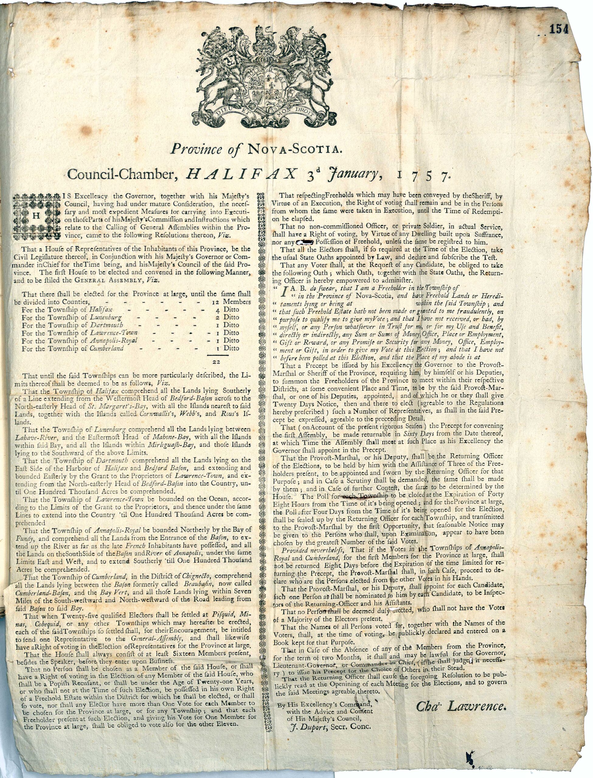
II . The Early Constitutions

The natural starting point is Nova Scotia, not merely because it is the oldest, but because the Cornwallis documents furnished the foundation for later constitutional progress.

The origin of the Nova Scotian constitution is to be found in the Commission and Instructions to Edward Cornwallis. The Commission, by Letters Patent dated May 6th, 1749, included the following elements:

  1. Appointment of the Governor, with provision that he comply with and perform the requirements of the Commission and Instructions, and also the requirements of later Orders in Council or Special Instructions under the Sign Manual and Signet
  2. Authority to “Chuse nominate & appoint such fitting and discreet persons as you shall either find there or carry along with you not exceeding the number of Twelve, to be our Council in our said Province”. It will be noted that the Council had a threefold function. It was a second chamber of the legislature, the Principal Court of Judicature, and an executive. Further, it was “Our Council”, and not the Governor’s Council
  3. Authority, with the advice and consent of the Council, to summon a General Assembly of the Freeholders and Planters according to the usage of the rest of the Colonies and plantations in America
  4. Grant of legislative power : “And you the said Edward Cornwallis with the advice and consent of our said Council and Assembly or the major part of them respectively shall have full power and authority to make, constitute and ordain Laws, Statutes and Ordinances for the Publick peace, welfare and good government of our said province and of the people and inhabitants thereof and such others as shall. resort thereto & for the benefit of us our heirs and Successors, which said Laws, Statutes and Ordinances are not to be repugnant but as near as may be agreeable to the Laws and Statutes of this our Kingdom of Great Britain”
  5. Provision for disallowance, without limitation as to time
  6. Provision for veto: “And to the end that nothing may be passed or done by our said Council or Assembly to the prejudice of us our Heirs & Successors We Will and Ordain that you the said Edward Cornwallis shall have and enjoy a Negative Voice in the making and passing of all Laws, Statutes & Ordinances as aforesaid”
  7. Authority to establish Courts of Justice
  8. Authority to pardon offenders, “Treason and willfull murder” being reserved for the “Royal Pleasure” .
  9. Measures concerning militia, defence and naval discipline
  10. Provision for administration of finance
  11. Provision for disposition of crown lands

The Instructions dated April 29th, 1749, are very lengthy. (Public Record Office, C.O. 218/3, pp.60-73, 80-81) Special mention might be made of those that concern the administration of justice:

  1. The 66th to the 70th Articles provide for the establishment of the General Court, consisting of the Governor and Council, as the Principal Court of Judicature, and authorize the formation of inferior courts.
  2. The, 71st to the 81st Articles provide for impartial and speedy justice and liberty of the subject secured by habeas corpus . With the 82nd Article, they constitute an effective charter of civil liberties.’

71st. And Whereas frequent Complaints have been made of great Delays and undue proceedings in the Courts of Justice in several of Our Plantations, whereby many of Our Subjects have very much suffered, and it being of the Greatest Importance to Our Service and to the Welfare of Our Plantations, that Justice be everywhere speedily and duly administered, and that all Disorders, Delays and other undue Practices in the Administration thereof be effectually prevented, We do particularly require you to take especial Care that in all Courts, where you are authorized to preside ; Justice be impartially administered, and that in all other Courts established within Our said Province all Judges and other Persons therein concerned do likewise perform their several Duties without Delay or Partiality.

72nd. You are to take Care that no Court of Judicature be adjourned but upon good Grounds, as also that no Orders of any Court of Judicature be entered or allowed which shall not be first read and approved of by the Magistrates in open Court, which Rule You are in like manner to see observed with relation to the Proceedings of Our Council of Nova Scotia, and that all Orders there made be first read and approved in Council before they are entered upon the Council Books.

73rd. Whereas We are above all things desirous that all Our Subjects may enjoy their Legal Rights and Properties, you are to take especial Care that if any Person be committed for any Criminal Matters (unless for Treason or Felony plainly and especially expressed in the Warrant of Commitment) he have free Liberty to petition by himself or otherwise for a Writ of Habeas Corpus, which upon such Application shall be granted and served on the Provost Marshall Goaler or other Officer having the Custody of such Prisoner, or shall be left at the Goal or Place where such Prisoner is confined; And the said Provost Marshall or other Officer shall within three Days after such Service (on the Petitioners paying the Fees and Charges and giving Security that he will not escape by the way) make Return of the Writ and Prisoner before the Judge who granted our the said Writ, and there certify the true Cause of the Imprisonment, and the said Judge shall discharge such Prisoner taking his Recognizance and Security for his Appearance at the Court where the Offence is cognizable, and certify the said Writ and Recognizance unto the Court, unless such Offences appear to the said Judge not bailable by the Laws of England.

74th. And in Case the said Judge shall refuse to grant a Writ of Habeas Corpus on View of the Copy of Commitment or upon Oath made of such Copy having been denied the Prisoner or any Person requiring the same in his behalf, or shall delay to discharge the Prisoner after the granting of such Writ, the said Judge shall incur the Forfeiture of His Place.

75th. You are likewise to declare Our Pleasure, that in Case the Provost Marshall or other Officer shall imprison any Person above twelve Hours, except by a mittimus setting forth the Cause thereof, he be removed from his sd. Office.

76th. And upon the Application of any Person wrongfully committed the Judge shall issue His Warrant to the Provost Marshall or other Officer to bring the Prisoner before him, who shall be discharged without Bail or paying Fees, and the Provost Marshall or other Officer refusing Obedience to such Warrant shall be thereupon remov’d, and if the said Judge denies his Warrant he shall likewise incur the Forfeiture of his Place.

77th. You shall give Directions that no Prisoner being set at large by an Habeas Corpus be recommitted for the same Offence but by the Court where he is bound to appear, and if any Judge, Provost Marshall or other Officer contrary hereunto shall recommit such Person so bailed or delivered, you are to remove him from his Place, and if the Provost Marshall or other Officer having the custody of the Prisoner neglects to return the Habeas Corpus, or refuse a Copy of the Commitment within Six Hours after Demand made by the Prisoner or any other in his behalf, he shall likewise incur the Forfeiture of his Place.

78th. You are to take Care that all Prisoners in Cases of Treason or Felony have Free Liberty to Petition in open Court for their Trials that they be indicted at the first Court of Oyer and Terminer unless it jappear upon Oath that the Witnesses against them could not be produced, and that they be tried at the second Court or discharged : and the Judge upon Motion made the last Day of the Session in open Court shall discharge the Prisoner accordingly, and upon the Refusal of the said Judge and Provost Marshall _ ” or other Officer to do their respective Duties herein they shall be removed from their Places .

79th. Provided always that no Person be discharged out of Prison who stands-committed for Debt by any Decree of Chancery or any Legal Proceedings of any Court of Record.

80th. And for the preventing of any Exactions that may be inadp upon Prisoners you are to declare our Pleasure, that no Judge shall receive for himself or Clerks for granting a Writ of Habeas Corpus more than 2s. 6d. and the like sum for taking a Recognizance, and that the Provost Marshall or other Officer shall not receive more than 5s. for every Commitment, 1s . 3d. for the Bond the Prisoner is to Sign, 1s. 3d. for every Copy of a Mittimus and 1s . 5d. for every mile he bringeth back the Prisoner .

81st. And further You are to cause this Our Royal Pleasure Signified to You by the Nine Articles of Instructions immediately preceding this to be made publick, and registred in the Council Books of Our said Province.

82nd. You are to take Care that no Man’s Life; Member, Freehold or Goods be taken away or harmed in Our said Province under Your Government otherwise than by Established and known Laws, not repugnant to but as near as may be- agreeable to the Laws of this Kingdom, and that no Persons be sent as Prisoners to this Kingdom from our said Province without sufficient Proof of their Crimes, and that Proof transmitted along with the said Prisoners.

  1. The 83rd Article provides that “all writs within our said Province be issued in Our Name”. Thus, in the administration of justice, as in the executive government, it was the King’s Court, and not the Governor’s Court, that judged.
  2. the 85th Article provided for appeals from the inferior courts to the General Court; and, in matters involving more than £300, an ultimate appeal to the Privy Council.
  3. The 94th Article provided for reservation of bills “of an unusual and extraordinary Nature and Importance, wherein Our Prerogative or the Property of our Subjects may be prejudiced, or the Trade and Shipping of this Kingdom any ways affected”; unless they contained “a clause inserted therein suspending and deferring the Execution thereon until” the King’s pleasure concerning them became known (E.g., Instructions to Governor Wilmot, March 16th, 1764 : Can. Sess. Papers, 1883, No. 70, p. 30.)

The provisions regarding appeals were modified by Additional instructions to Colonial Governors, including Nova Scotia, dated December 3rd, 1753 (P.R.O., C.O. 324/15 , pp. 342-346) whereby provision was made for appeals to the Governor and Council in cases involving upwards of £300; and for ultimate appeal to the Privy Council, in cases involving upwards of £500 and in cases involving revenue matters or future rights even if the amounts involved were less. This measure was later incorporated into the-regular Instructions.

Read, J. E. “The Early Provincial Constitutions” Canadian Bar Review Vol 26 No 4, 1948. https://cbr.cba.org/index.php/cbr/article/view/1501/1501

On the origin and sources of the Law of Nova Scotia

The preface to Volume One of the Epitome acknowledges James Kent’s Commentaries on American Law’s usefulness. Murdoch, like Kent, was concerned with the “reception” of English law. He based Nova Scotia’s law on its statutes, interpreting them in light of English law. Murdoch’s success in this historical legal endeavor was remarkable, with no attempt to supersede or replicate the Epitome for subsequent Nova Scotian legal developments.

Nova Scotia’s history of governance is traced from French rule to English sovereignty. The province transitioned from French edicts to English law, with the monarch exercising legislative power through appointed governors and instructions. The establishment of courts and assemblies under royal authority shaped Nova Scotia’s legal system.

The province adopted English common law and statutes, with the Crown retaining legislative power, evidenced by various governmental changes without legislative involvement. Murdoch emphasizes the importance of consulting English legal principles, colonial American treatises, and provincial statutes for legal guidance.


“In his preface to volume one of the Epitome, Murdoch also acknowledged the usefulness of the four volume Commentaries on American Law, which James Kent, Chancellor of New York, published between 1826 and 1830. Murdoch, like Kent, was much concerned with the pressing problem of “reception” of English law. His device for dealing with it was to found Nova Scotia’s law firmly on the Province’s statutes, construing them in the light of English law, both common and statutory, and according to English law recognition only of so much of it as clearly remained in force in Nova Scotia because of the want of Nova Scotia statutory enactment. Perforce, such an undertaking was an exercise in legal history-a very obscure and confused legal history at that. His success was remarkable: none since has attempted to supersede the Epitome or to replicate it for subsequent Nova Scotian legal developments. Beamish Murdoch can justly be called the first-and greatest-legal historian of Nova Scotia.”

“Acadie, or Nova Scotia, was conquered by General Nicholson in 1710, and was ceded in 1713, by Louis 14, to Queen Anne by the Treaty of Utrecht prior to which it was governed by the edicts and orders of the King of France.

From 1710 to 1749 (when a Government was established at Halifax) the administration of the government was vested in a Governor and Council at Annapolis Royal.

During this period, each of the French Settlements, viz., that of the Annapolis River, Mines, Piziquid and Chignecto, elected annually a number of deputies. It was the duty of the deputies to wait on the Governor and Council at Annapolis Royal, and they formed a medium of communication between the Government and the people, receiving and publishing orders, etc., and it was considered to be their especial duty to carry into effect the orders of the Government.

Prior to the Treaty of Utrecht in 1713, the province was governed by the orders and edicts of the French Monarch; and in matters of law, I believe the coutume de Paris was followed in Acadie, as it was in Canada, both of which were included under the name of New France.

On the conquest and subsequent cession of this country to the English Crown, the Monarch of England became sole lord and proprietor of the dominion, with the full right of legislating for the land and its inhabitants. This power was exercised only as far as necessity demanded, and only by means of the commissions issued by the Crown to the several Governors and the royal instructions given in connection with them. Directions were usually given with them to appoint a Council of twelve members selected from the principal inhabitants and settlers. Governor Philipps, in 1720, was obliged to fill up this number chiefly from the military and civil officers of the garrison of Annapolis, as the noblemen and chief inhabitants had abandoned the country on the conquest and the remaining inhabitants were not only wanting in the education and property requisite to qualify them for the position, but being Roman Catholic were considered ineligible by law under the tenor of the royal instructions and the acts of parliament then in force. Some of the Governors were desiring to appoint inhabitants to the office of justices of the peace, but they were forbidden to carry this into effect by the replies they received from the Lords of Trade and Plantations, who at that time formed a board for the management of colonial affairs.

The royal instructions also authorized the establishment of Courts of Justice in the colony. Under this authority the Governor and Council formed themselves into a General Court, with civil and criminal jurisdiction, sitting in four terms annually, without juries of any kind. This Court was held at Annapolis. The Governor also acted as Judge of Probate; and at Canso, where the English colonists held possession and resorted in numbers every summer for the fishery, Justices of Peace were appointed, and a committee chosen by the people acted in some respects as an Assembly.

The Council continued to be chiefly composed of the military Officers until 1749, and even then several were appointed in the first Council at Halifax.

In the instructions to the Governor of Nova Scotia there were always directions to call an assembly of the people, but owing to the almost entire absence of British inhabitants this instruction remained long inoperative.

The first House of Assembly met accordingly in 1758, all the freeholders of the province uniting in the elections at Halifax, as if it were one county. From this time forth legislation proceeded regularly, and the popular branch of government has gradually obtained the control of all the revenue and Crown property of the province.

Our assemblies, like those of several of the older British provinces, have been modelled in some respects after the Parliament of England; the Governor forming one branch as representing the Sovereign-His Majesty’s Council sitting as a House of Lords-and the representatives as a House of Commons. Colonies thus governed were (before the American revolution) called Crown Colonies, to distinguish them from those who had, like Massachusetts, a constitution underwritten charter from the King, or like Pennsylvania, a lord proprietor with peculiar rights and privileges.

The idea is, that in founding a province, we receive and adopt the general English Common Law, together with such ancient statutes as are considered to virtually form a part of it, such as the statutes of Magna Carta, Westminster, etc., for example; and that from the time of the erection of our local legislature, we take the Acts passed in the province only as imperative, unless where the Parliament in England, acting in the capacity of a Sovereign legislature over the whole British dominions or empire and nation expressly directs the clauses of a law to be in force in the colony.

We are also bound by a rule of great importance, in the observation of such decisions of the Courts of Law in the mother country, as elucidate the doctrines of the Common Law, define the privileges and prerogatives of the Crown, or throw light on statute law in force among us, either British or Provincial Acts.

Although changes of sovereignty have happened in a large proportion of the older colonies of England, yet, we find much valuable information bearing directly on our legal learning in the large number of American treatises and reports of the Courts of Law in the United States. In like manner the decisions of the Supreme Court in the sister province of New Brunswick are well worthy of our attention

If there be not clear decisions or texts of authority in English writers to solve the problem, our attention should be next directed to the reports of decisions in New England and other States, originally English colonies, to find out whether a decision or practice may not be contained in them to throw light on the point, as most of the adjudged cases in the United States, especially in New England, have been heretofore grounded on the ancient principles and maxims of the English Common Law, and modified by the circumstances and emergencies of new countries. The Statutes of our own Province, where they have a bearing on the inquiry and the cases reported in this and the sister provinces, are of course to be consulted.

That the sovereign legislative power of the Crown was not abandoned or supposed to cease on the erection of a Provincial assembly in Nova Scotia may be gathered from the several Acts of Government which occurred at different periods since, and which have all been acquiesced in.

1. The changes from viewing the province as one county with a Provost Marshal General, into several counties with Sheriffs, and from the election of all the representatives in a body by the freeholders of the province to representatives chosen by counties, districts and to townships, by act of the Crown (by order of Council in 1759).

2. A change (1765) from two members for every township to one member, by Act of Government, which, though complained of, was submitted to and confirmed by Provincial Act of that year.

3. The severance of New Brunswick in 1784 into a distinct province, the same being part of the territory of this Province and having its representatives in our assembly. This was effected by order of the Crown, without even notice previously to the Government or to the Assembly of Nova Scotia.

4. The island of Cape Breton was annexed to Nova Scotia in 1763, servered from it in 1784, and again annexed to it in 1820, all those changes were made by orders of the King, without any legislative interference.

5. In 1838, the constitution of the Government and Legislature were changed by orders of the Sovereign. The old council of 12 was abrogated and two councils substituted, and executive council and a legislative council, the latter a greater number of members than the old council.

Here are several organic changes in form of Government and in territory which were all completed without Acts either of the English or of the Provincial Parliament by the sole and exclusive authority of the Crown, and they are all subsequent to the calling of our first assemblies, and have occurred at distant periods in the last and present centuries.”

Beamish Murdoch, “On the origin and sources of the Law of Nova Scotia” (An essay on the Origin and Sources of the Law of Nova Scotia read before the Law Students Society, Halifax, N.S., 29 August 1863), (1984) 8:3 DLJ 197. https://digitalcommons.schulichlaw.dal.ca/cgi/viewcontent.cgi?article=1399&context=dlj

The American Revolution and Nova Scotia Reconsidered

“The New Englanders, moreover, were greatly dissatisfied with the Halifax government. Had not Francklin encouraged the Yorkshiremen to settle in the Isthmus? Furthermore, the New Englanders reacted violently to the fact that a small clique of Halifax merchants controlled the legislative and executive functions of government stubbornly refusing to grant to the New Englanders the right of ”township form of government” which Governor Lawrence had promised them in 1758 and 1759″

“What real impact did the Revolution have upon the inhabitants of Nova Scotia? Of course most of them resolved to adopt a policy of neutrality; many suffered because of the depredations of the American privateers; while a few, especially the Halifax merchants, grew rich from the usual profits of war. But was there nothing else? M. W. Armstrong has convincingly argued that probably the most important impact of the Revolution upon Nova Scotia was in precipitating the “Great Awakening of Nova Scotia.” In addition, Armstrong has emphasized that the “Great Awakening” encouraged the development of neutrality:

Indeed, the Great Awakening itself may be considered to have been a retreat from the grim realities of the world to the safety and pleasantly exciting warmth of the revival meeting, and to profits and rewards of another character … an escape from fear and divided loyalties … an assertion of democratic ideals and a determination to maintain them, the Great Awakening gave self respect and satisfaction to people whose economic and political position was both humiliating and distressing.

The prophet and evangelist of the spiritual awakening was Henry Alline who, when he was twelve, had moved from Rhode Island to Falmouth, Nova Scotia. An uneducated farmer, Alline had experienced an unusual “Conversion”, and in 1776 he began to preach an emotional Christian message that has been described as being a combination of “Calvinism, Antinomianism, and Enthusiasm.” The flames of religious revival swept up the Minas Basin in 1777, across the Bay of Fundy in 1779, and to the South Shore in 1781. All Protestant Churches in Nova Scotia were in one way or another affected by the “Great Awakening”, and largely as a direct result the evangelical wing of the various Protestant Churches was able to dominate Maritime religious life throughout the nineteenth century”

Rawlyk, George A. “The American Revolution and Nova Scotia Reconsidered”, Dalhousie Review, Volume 43, Number 3, 1963 https://dalspace.library.dal.ca/bitstream/handle/10222/62718/dalrev_vol43_iss3_pp379_394.pdf

To authorize an assessment on the inhabitants of the Town Plot of Dartmouth, 1866 c56

To assess the inhabitants of the (Dartmouth) Town Plot, 1866 c56

An Act to authorize an Assessment on the inhabitants of the town plot of Dartmouth.
(Passed the 7th day of May, A. D. 1866.)

SECTION

1. Inhabitants of Dartmouth may assess themselves for $600 to obtain plan of township.
2. Commissioners of Streets may borrow said amount.
4.(sic) Amount to be repaid in three years,
4. General or Special Sessions may assess for amount.

Be it enacted by the Governor, Council, and Assembly, as follows:

Inhabitants of Dartmouth may assess themselves for $600 to obtain plan of township:
1. The rateable inhabitants residing within the town plot of the township of Dartmouth, in the county of Halifax, may selves for $600 assess themselves, at any public meeting to be called for the purpose by any three of the Justices of the said county, notice of such meeting having been first given by handbills posted up within the limits of such town plot at least ten days previous to such meeting, in a sum not exceeding six hundred dollars, for the purpose of obtaining a good and sufficient plan of said town plot.

Commissioners may borrow said amount:
2. The Commissioners of Streets for the said township are hereby authorized to borrow the sum of six hundred dollars for the purpose aforesaid, by pledging the security of this act.

Amount to be repaid in three years:
3. Such sum and interest thereon, at the rate of six per centum per annum, shall be repaid in three years in the following manner, viz., the sum of two hundred dollars and interest in one year, the sum of two hundred dollars and interest in two years, and the sum of two hundred dollars and interest in three years, from the time such sum of six hundred dollars is so borrowed.

General and Special Sessions may assess for amount:
4. A general or special sessions shall assess such amounts as aforesaid upon the inhabitants of the said town plot, and the same shall be collected and enforced in the same manner as poor and county rates are now collected and enforced.

“To authorize an assessment on the inhabitants of the Town Plot of Dartmouth”, 1866 c56

Page 5 of 7
1 2 3 4 5 6 7