Opposite the Town of Halifax, the Town called Dartmouth was laid out in the Year 1749; but in the war of 1756, the [Mi’kmaq] collected in great force on the basin of Minas, ascended the Shubenacadie in their canoes, and in the night surprised the guard, and killed, scalped, or carried away the most of the settlers; from which period the settlement went to decline, and was almost derelict until the year 1784, when a number of families were encouraged to settle there from Nantucket, to carry on the whale fishery. The town was then laid out in a new form, and cultivation and business revived with spirit and activity, and very encouraging expectations were formed of success in the whale fishery by all concerned in it, until these enterprising people were persuaded, by liberal encouragement, to quit this Country, and remove to Whitehaven in England, where they settled, and became connected with merchants of great capital.
N.B. – The Town of Dartmouth took its name from the Earl of Dartmouth, the Secretary of State for the Colonial Department of that day.
The remaining townships within the County of Halifax are Lawrencetown, Preston, Truro, Onslow, and Londonderry.”
Wilmot Horton, Robert. Cockburn, Francis. “Instructions under the direction of the Secretary of State for the Colonial Department : communicated to Lieut. Col. Cockburn by the Rt. Honorable R.W. Horton in a letter dated 26th January 1827, with a letter and appendix addressed to the Rt. Honorable R.W. Horton by Lieut. Col. Cockburn, detailing the execution of these instructions.” Great Britain. Colonial Office. [S.l. : s.n., 1827?] https://www.canadiana.ca/view/oocihm.59329
Nova Scotia’s governance evolved from a single governor to a structured system by 1719, with an advisory council. The pivotal year of 1758 saw a shift towards self-government, limiting the Crown’s direct legislative authority with the grant of an assembly. Despite the theoretical right of the Crown to appoint council members at pleasure, practical considerations led to a de facto life tenure by 1867. This framework persisted until Nova Scotia’s entry into the Dominion of Canada in 1867, with the lieutenant governor retaining the authority to suspend or dismiss individual council members, but unable to unilaterally alter the council’s constitution.
The Legislative Council, established in 1719, underwent reform in 1838, splitting into separate Executive and Legislative Councils. Over time, the Legislative Council became viewed as antiquated, especially after Confederation transferred significant concerns to the Dominion Parliament. While other provinces abolished their Legislative Councils relatively easily, Nova Scotia struggled for decades from 1879 to 1928. Premier William Stevens Fielding even petitioned the Queen and Westminster for abolition but was met with refusal.
However, in 1911, the passage of the imperial Parliament Act shattered the temporary ceasefire regarding the Legislative Council’s existence. Despite the lieutenant governor’s inability to unilaterally abolish the council, individual dismissals were used to effectively dismantle it. This action disrupted the constitutional machinery, demonstrating how the lieutenant governor’s power to suspend or dismiss council members could be strategically wielded to circumvent the council’s constitutional protections and achieve its abolition.
For a few years the government of Nova Scotia was vested solely in a governor, who had command of the garrison stationed at the fort of Annapolis, known as Port Royal in the days of the French regime. In 1719 a commission was issued to Governor Phillips, who was authorized to appoint a council of not less than twelve persons, all of whom held office during pleasure. The governor, in his instructions, was ordered neither to augment nor diminish the number of the said council, nor suspend any of the members thereof, without good and sufficient cause… This council had advisory and judicial functions, but its legislative authority was of a very limited scope.
Consequently the year 1758 is the commencement of a new epoch in the constitutional history of Nova Scotia. We find then from that time a civil government duly organized as in other English colonies of America, generally known as provincial governments. We find (1) a governor the head of the executive authority and a branch of the legislature, having a negative or affirmative voice in all legislation, appointed by the King and acting under the royal commission and instructions. (2) A council, appointed during the pleasure of the Crown, to act as an advisory body and also as an upper house of the legislature. (3) A house of assembly elected by the inhabitants of the province in accordance with law. As in all other colonies of the Crown of North America, these three branches, governor, council and assembly, passed such statutes and laws as were necessary for their internal regulation and were subject to the general control of the Queen-In-Council and the Parliament of Great Britain as the supreme executive and legislature of the whole British Empire.
Previous to 1758 the Sovereign-In-Council exercised all powers of government through the exercise of the royal prerogative, as in the case of all ceded or conquered countries. The constitution of Nova Scotia has always been considered previous to 1867 as derived from the terms of the royal commissions to the governors and lieutenant-governors, and from the instructions which accompanied the same, from imperial orders-in-council, from dispatches from the imperial secretary of state conveying the will and wishes of the imperial government, from acts of the imperial parliament immediately applicable to the colony, and from acts of the local legislature approved by the Crown, and “the whole to some extent interpreted by uniform usage and custom in the colony.
Previous to 1758 the governor and council, acting under royal instructions, were practically supreme in the exercise of powers of local government. From that day, however, Nova Scotia was vested with large powers of self-government. It is a fundamental principle that although a sovereign has the right to legislate for a conquered country by virtue of his royal prerogative, yet he ceases to have that power after he has authorized and directed the summoning of a representative legislative assembly. By granting an assembly to Nova Scotia in 1758, he precluded himself from legislating directly for the colony by virtue of his royal prerogative and irrevocably granted to the people the constitutional right of exercising all subordinate legislation over the province by an assembly with the consent of the governor and council. In this system of government the Crown continued to exercise large powers of control since it was represented by a governor having the right to negative all acts of the other two branches, and having in addition the appointment and supervision of the men constituting the upper house of the legislative power. With all its inherent defects which were to show themselves in the course of the ensuing eighty years, the change in the system of government, however, was very much in advance of the previous condition of things. From that time forward, there was an organized constitution solemnly granted by the Crown for legislative purposes. A governor, legislative council and an elected assembly represented collectively a complete legislature.
For nearly ninety years this system of government continued in force. Parliamentary government, in the modern sense of the term, never obtained, but the government of the country was virtually under the control of the council exercising executive, legislative and judicial powers. In the course of time a contest grew up between the irresponsible council and the people’s house for the management of all the public taxes and finances, for the separation of the executive and legislative functions of the council, and “for the responsibility of the members of government to the assembly.” As a remedy for existing grievances, an address to the Queen, passed by the house of assembly in 1837, prayed that “Her majesty should grant an elective legislative council,” or “should separate the executive from the legislative council;” provide “for a just representation of all the great interests of the province in both”; introduce the executive “some members of the popular branch,” and otherwise secure “responsibility to the Commons, and in that way confer upon the people of the province what they value above all other possessions, the blessings of the British constitution.”
Writing in 1829, Judge Haliburton observes: “By making the members of the council independent of the governor for their existence (for at present he has not only the power of nomination, but of suspension) and investing them with no other powers than those necessary to a branch of the legislature much weight would be added to the administration, on the confidence and extent of interest that it would thereby obtain, a much more perfect and political distribution of power would be given to the legislature, and the strange anomaly avoided of the same persons passing a law and then sitting in judgement on their own acts, and advising the governor to assent to it.”
In 1845 the legislative council of Nova Scotia passed an address to Her Majesty complaining of certain difficulties that had arisen since the remodeling of the council on account of gentlemen residing in the rural districts being unwilling to accept the position of legislative councillor “either from the want of a defined constitution or of a pecuniary provision for the expense of the attendance of the country members.”
All that they asked for was a “defined constitution.”
The colonial secretary of the day, Lord Stanley…assigned reasons why it was not possible to make pecuniary provision for the payment of the members, and then proceeded to discuss “the second proposal, that the tenure of office of a legislative councillor should be during his life, and not during His Majesty’s pleasure.” No such second proposal in exact words, it is well to note, was made in the address of the legislative council, as may be seen by reference to the preceding paragraph No. 17. All that they asked for was a “defined constitution.”
I have now reviewed the constitutional history of the legislative council of Nova Scotia, from its origin in the early part of the eighteenth century down to the first day of July, 1867, when, in accordance with the British North America Act of 1867, Nova Scotia became a province of the federal union known as the Dominion of Canada. This imperial act provides that the lieutenant governor shall be appointed by the governor general of the Dominion; that the constitution of the executive authority of Nova Scotia “shall, subject to the provisions of this act, continue as it exists at the union, until altered under the authority of this act;” that the constitution of the legislative council of Nova Scotia, shall, “subject to the provisions of this act, continue as it exists at the union until altered under the authority of this act.” In the ninety-second section, setting forth the subjects of exclusive provincial legislation, it is enacted that “in each province the legislature may exclusively make laws in relation to matters coming within the classes of subjects hereinafter enumerated;” and the first subject so enumerated is “the amendment from time to time, notwithstanding anything in this act, of the constitution of the province, except as regards the office of lieutenant governor” -the governor-general in council alone having the power to appoint, dismiss, and instruct that functionary as respects his relations with the Dominion government. In the exercise of this power of amendment, the legislature of Nova Scotia is supreme.
One thing is clear, that from 1719 to 1861 – from Governor Phillips until Governor-General Monck, whose commission and instructions held good until 1867 – the legislative councillors, as well as executive councillors, held office during pleasure of the Crown. But while this is no doubt the strictly legal and technical interpretation to be given to the commission and instructions, it is necessary to consider that the constitution of England and of all her dependencies is largely governed by conventions, understandings and usages which may not be law in an exact technical sense, but which, nevertheless, have the force of law in operation of the system we possess. In coming to any conclusion with respect to the tenure of office of legislative Councillor, these usages and understandings must have weight, and therefore, I shall endeavor to deduce the principles that seem well established.
From 1719 until 1867 there were three well defined periods in the constitutional history of the province.
From 1719 until 1758, when the governor and council, with executive and legislative powers, alone carried on the government.
From 1758 until 1838, when the government was in the hands of a governor, a council with legislative and executive functions, and assembly elected by the people.
From 1838 until 1867, when the government was entrusted to a governor, an executive council, a legislative council, an assembly, and the province obtained the concession of responsible government.
Briefly summed up, the constitution of Nova Scotia in this particular was in 1867 as follows, in my opinion:
The legislative council formed a nominated or upper house of a legislative body, the other branches of which were a lieutenant governor representing the Crown, and an assembly representing directly the people.
The council formed part of a system of legislative and constitutional government sanctioned by the sovereign in 1758. This house had legislative functions co-ordinate with those of the assembly except as respects bills of revenue, expenditure, and taxation, which it could not initiate or amend though it might reject them.
That in granting that constitution, and in conceding legislative rights to the people in 1758, the Sovereign gave up his rights to legislate directly by prerogative, and the Crown in parliament, as the supreme legislative authority of the Empire, could alone legislate for the province as for other dependencies of the Empire, in matters of imperial concern and necessity.
That the rights of legislation conceded to Nova Scotia were given to three branches, and not to one alone, and that the legislative council as a whole had absolute rights and responsibilities as part of the legislative framework, and its place in that structure should not be disturbed by an arbitrary exercise of the royal prerogative. It is a question whether at any time after 1758 the Crown could constitutionally legislate it away as a whole body by the mere exercise of the royal prerogative, though it might increase and limit its membership and regulate the tenure of office, since a total abolition would seem to be an infringement of the constitution conceded to Canada in 1758. The crown in parliament could alone suspend or legislate away the constitution of the province, after the Crown had conceded the right of legislation and self-government by three branches, as was done in Lower Canada in 1838 and proposed by Lord Melbourne in the case of Jamaica in 1839.
That while the Crown had not given up its theoretical right to appoint members of the council only during pleasure, it had be agreement and usage for many years previous to 1867 practically yielded its right, and conceded a tenure for life, subject to certain rules and conditions as set forth in the dispatch of 20th August, 1845.
That consequently, in the opinion of the writer, the constitution of the council up to 1867 was unalterable except by the authority of the Crown in parliament, and its individual members were subject to certain conditions accompanying a tenure during good behavior for life.
That since 1867 the constitution of the council remains as just set forth, subject to such amendments and alterations as have been made by the statutory authority vested by the British North America Act of 1867 in the legislature of the province.
That the lieutenant governor of the province, as representing the Crown, may suspend or dismiss a legislative councillor, who falls within the conditions of the dispatch of August 20th, 1845, but he has no power to interfere with the constitution of the legislative council as a whole, or by the cancelling of the commissions and consequent dismissal of members, one by one, to abolish the body, as that would be as important a part in the operation of the constitutional machinery as any statutes, which give at once flexibility and stability to the framework and enable it to work as a rule with remarkable effectiveness, and which cannot be rudely touched and broken without doing undeniable injury to the whole fabric of government in the Dominion and its provinces.
“Dartmouth, on the opposite side of the safe and spacious harbour, offered an inviting appearance for the formation of a village, and in one year after the foundation of Halifax, some of the company of Lord Cornwallis passed over and commenced a settlement. But a sad catastrophe befell the little town: in six years from its beginning it was destroyed by [Mi’kmaq], who made an irruption upon it from the forest in its rear, destroying with merciless cruelty the inhabitants, demolishing the houses and laying waste the newly tilled lands.”
“Dartmouth was founded in 1750, but in 1756 it was destroyed by the [Mi’kmaq]. In 1784 it was again settled by emigrants from Nantucket, most of whom removed in 1793. Since that time its population has gradually increased. The townships of this county-are Halifax, Dartmouth, Laurencetown (sic) and Preston. The first of these has two representatives in the Assembly.”
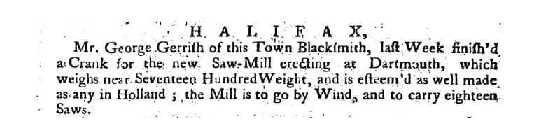
“Mr. George Gerrish of this Town Blacksmith, last week finished a Crank for the new Saw-Mill erecting at Dartmouth, which weighs near Seventeen Hundred Weight, and is esteem’d as well made as any in Holland; the Mill is to go by Wind, and to carry eighteen Saws.”
“Dartmouth, which was settled in the year after the founding of Halifax, suffered most from the [Mi’kmaq]. Six men belonging to this place were attacked whilst cutting wood in the forest; four of them were killed and scalped, and one was taken prisoner. A few months afterwards, the [Mi’kmaq], having crept upon the settlement during the night, killed and scalped several of the panic stricken inhabitants. The screams of the terrified women and children were heard across the harbour in Halifax. The governor and council, unwisely adopting the barbarous custom of the [Mi’kmaq], offered large rewards for [indigenous] prisoners and [indigenous] scalps.”
“Dartmouth (4300) is about a mile from Halifax, on the opposite side of the harbour. It has various manufactures, among them are hempen rope and skates of superior quality. Near the town is the Provincial Lunatic Asylum.”
Between 1746 and 1894, Dartmouth’s history unfolds with significant events including the arrival of settlers, establishment of saw-mills, and conflicts with the Mi’kmaq people. Dartmouth saw fluctuations in population, the building of churches and other infrastructure, and incorporation as a town in 1873. Economic activities like shipbuilding, ferry services, and the discovery of gold at Waverley mark periods of prosperity. However, tragedies such as fires, mysterious disappearances, and drowning incidents also punctuate Dartmouth’s timeline.
The town experienced advancements such as the introduction of steamboats, electricity, and the establishment of amenities like bathing houses and public reading rooms. Infrastructure projects like railway construction, water supply, and sewerage systems reflect efforts to modernize Dartmouth. Despite setbacks like bridge collapses and refinery closures, the town continued to evolve and grow, reaching a population of over 6,000 by 1891.
1746-1799
Duc d’Anville arrived at Chebucto, 10 Sept 1746
Halifax founded, 21 June 1749
[Mi’kmaq] attacked 6 men at Maj. Gilman’s saw-mill, Dartmouth Cove, killing 4, 30 Sept 1749
“A list of the families in part of Nova Scotia, dated Halifax, July, 1752, states that there were within the town of Dartmouth: 53 families, 81 males above sixteen, 47 females above 16, 29 males under 16, 38 females under 16; Total (population) 193.”
Nova Scotia. Commissioner of public records, Benjamin Curren, and Thomas B. Akins. Selections From the Public Documents of the Province of Nova Scotia. Halifax, N. S.: C. Annand, 1869. (p 670)
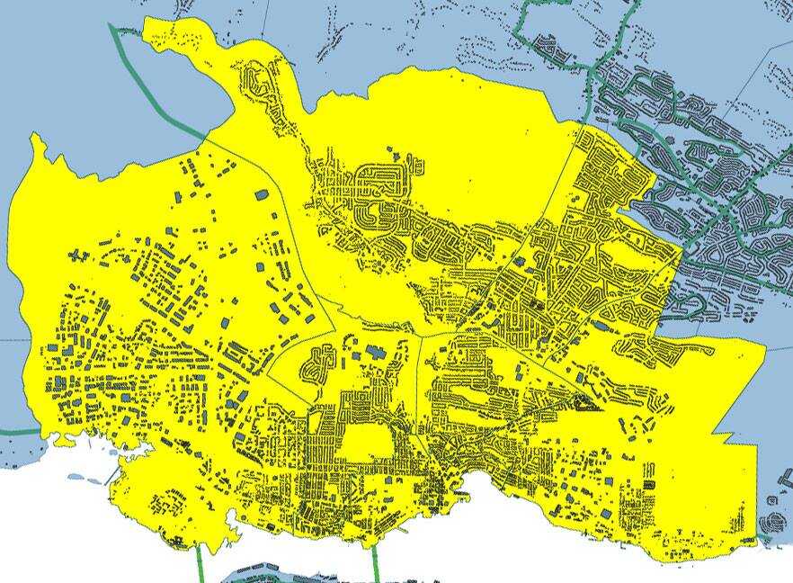
An examination of the legislated spatial dimensions of Dartmouth – from its initial definition as a township care of the Royal instructions that accompanied Cornwallis in 1749 to its dissolution in one of Nova Scotia’s city county mergers by fiat (aka a “municipal coup”) in 1996.
“And whereas for the better security, regulation and government of our said settlement, it will be necessary that such persons as we shall judge proper to send to our said province should be settled in townships; you are therefore hereby authorized and required to appoint such proper persons as you shall find there fully qualified to carry along with you forthwith to survey and mark out the said townships in such manner and at such places as is herein directed, that is to say, two townships containing 100,000 acres of land each be marked out at or near our harbor of Chebucto, as also one township of the like extent at each of the aforementioned places or such others as you shall judge most proper; and you are to take particular care in laying out such townships that they do include the best and most profitable land and also that they do include the best and most profitable rivers as may be at or near the said settlements and that the said townships do extend as far up into the country as conveniently may be, taking in a necessary part of the seacoast”.
“That the Township of Dartmouth comprehend all the Lands lying on the East Side of the Harbour of Halifax and Bedford Basin, and extending and bounded Easterly by the Grant to the Proprietors of Lawrence-Town, and extending from the North-easterly Head of Bedford Basin into the Country, until One Hundred Thousand Acres be comprehended.”
“Common of the town of Dartmouth…the common of the township of Dartmouth; situate on the eastern side of the harbour of Halifax, in special trust, for the use of the inhabitants settled and resident in the town plot, or that might thereafter settle, and actually reside, within the township of Dartmouth… Within the township of Dartmouth”
Chapter 2 of the Acts of 1797, “An act to enable the Governor, Lieutenant Governor, or Commander in chief for the time being, to appoint Trustees, for the Common of the Town of Dartmouth, on the death, or removal, of the Trustees holding the same, and to vacate that part of the grant of the Common aforesaid, which vests trust in the heirs, executors or administrators, of the Trustees, named in the said grant, on the death of such Trustees” http://0-nsleg–edeposit.gov.ns.ca.legcat.gov.ns.ca/deposit/Statutes/at_large/volume1/1797.pdf
“Town plot of Dartmouth… The said town… The town plot of Dartmouth, bounded on the North by the Common, on the South and West by the Halifax Harbour, and on the east by Mill Brook… Of the said towns respectively, within the said limits.”
“the Town of Dartmouth… inhabitants of the said town… the jurisdiction, powers and authority, of the commissioners so to be appointed for the said Town of Dartmouth, shall be confined and restricted to the bounds and limits following, that is to say:— to the direction or space of one Mile, measured in a southwardly, Easterly, and Northerly direction, from the Public Landing, or Steam Boat Company Wharf, in the said Town.”
“Whereas some uncertainty exists as regards the limits of the Township of Dartmouth… Be it therefore enacted by the Lieutenant Governor, Council and Assembly, that the lines of the Township of Dartmouth shall be established and settled as follows, beginning on the Eastern side of Bedford Basin at the head of Pace’s cove at low water mark, and thence to run north seventy four degrees east until it meets the main stream running Into Lake Major, thence southerly through the center of Lake Major and West Salmon River to the waters of Cole Harbor and thence Southwestwardly along the shore the several courses of the shore to Roaring Point, thence northerly following the course of the shore of the Main Land at low water mark to the place of beginning, so as not to include any Islands lying on or near said shore.
“…the inhabitants of the said town of Dartmouth …within the space of one mile, measured in a southwardly, easterly and northerly direction from the public landing or Steamboat Company’s wharf in said town”
For Dartmouth…one mile, measured in a southwardly, easterly and northerly direction from the public landing or Steamboat Company’s wharf in the said Town”
“After the first Annual Town Meeting in the Township of Dartmouth, Three Trustees of Public Property shall be chosen, in whom shall be vested the legal possession of the several Water Lots that have been reserved for the use of the Public along the shores of the Town Plot of Dartmouth, and of a certain Lot of Land and School House now known and distinguished as the School Lot, lying in the Town Plot, to be recovered, held and preserved by the Trustees for the uses to which the same respectively have been reserved and applied, but the School House and School Lot shall be preserved exclusively to the use of Schools and Education, and nothing herein shall excuse the possession and control of the Trustees to be appointed under the Act passed in the present Session for the support of Schools if the School House and Lot might otherwise come under control of such Trustees. Any other Public Property in the Township of Dartmouth not legally possessed by or under the charge and supervision of any person, shall also be legally vested in the Trustees appointed under this act… three trustees shall be annually thereafter appointed at each Annual Town Meeting of the Township… The Inhabitants, in Town Meeting, at any time may declare the purposes to which the Town Property shall be applied by the Trustees, provided those purposes shall not be inconsistent with the uses to which the property has been granted, reserved or legally appropriated… the next Annual Town Meeting of Dartmouth”
“The rateable inhabitants residing within the town plot of the township of Dartmouth, in the county of Halifax, may assess themselves, at any public meeting… for the purpose of obtaining a good and sufficient plan of said town plot… the inhabitants of the said town plot… The Commissioner of Streets for the said township…”
“The Trustees of the Dartmouth Common shall be a Body politic and corporate… the Commissioner of Streets for the Town of Dartmouth… A requisition signed by two thirds at least of the rate payers residing within the limits of the town plot of Dartmouth… Which town plot shall be construed to embrace an area within a distance of one mile measured in a southwardly, easterly and northerly direction from the public landing or Steamboat Company’s wharf in said town”
‘A municipality shall be erected within the County of Halifax, to be bounded as follows, that is to say: Beginning on the eastern side of the Harbor of Halifax, at a point in such Harbor distant three hundred feet Westerly from the South Western corner of a lot of land formerly owned by Judge Johnston and by him conveyed to John Esdaile; thence to run Eastwardly till it strikes the road leading to the property of the late John Esson; thence by the Southern side of such road and following the course thereof Eastwardly to such Esson property; thence along the Western boundary of such property, Southwardly to the South-Western corner thereof; thence Eastwardly to Gaston’s Road, and crossing such road to a point at right angles with the extension of a new road laid out by J.W. Watt through manor Hill Farm; thence Northwardly to such road and by such road for the length thereof; thence Northwardly to the causeway at Hurley’s on the First Lake; thence Northwardly to the North East boundary of Stair’s Ropewalk property; thence Westwardly to a point three hundred feet into the Harbor of Halifax; and thence Southwardly to then place of beginning; to be called and known as “The Town of Dartmouth”‘.
The inhabitants of the town of Dartmouth are constituted and declared to be a body corporate and politic by the name of the Town of Dartmouth. They shall as a corporation have perpetual succession and a Common Seal, changeable at pleasure, and shall be capable of suing and being sued in all Courts of Justice, and of acquiring, holding and conveying any description of property, real, personal or mixed, and shall have all the other rights usually had and enjoyed by corporations.
The Town of Dartmouth shall be bounded as follows:—
Beginning on the eastern side of the Harbor of Halifax, at a point in such Harbor distant three hundred feet Westerly from the South Western corner of a lot of land formerly owned by Judge Johnston and by him conveyed to John Esdaile; thence to run Eastwardly till it strikes the road leading to the property of the late John Esson; thence by centre of such road and following the course thereof Eastwardly to such Esson property; thence along the Western boundary of such property, Southwardly to the South-Western corner thereof; thence Eastwardly to Gaston’s Road, and crossing such road to a point at right angles with the extension of a new road laid out by J.W. Watt through manor Hill Farm; thence Northwardly to such road and by such road for the length thereof; thence Northwardly to the western extremity of the causeway at Hurley’s on the First Lake; thence Northwestardly through Taylor’s barn on the opposite side of the lake until it strikes the Southern side line of the road which connects with the new road laid out by G. A. S Chichton, thence following the southern line of said road until it reaches the main road leading from Dartmouth to Bedford; and from thence crossing said road in a straight line following the said line of the said new road until it extends three hundred feet into the harbor of Halifax, and thence Southwardly to the place of beginning to be called and known as “The Town of Dartmouth”.
“The inhabitants of the town of Dartmouth are constituted and declared to be a body corporate and politic by the name of the Town of Dartmouth, and the boundaries of the town of Dartmouth, the division of the same into wards, and the boundaries of the several wards thereof, shall continue as at the passing of this Act.”
Chapter 86 of the acts of 1886, “An Act to Amend the Acts relating to the Town of Dartmouth”
[Included is a copy of the 1886 Statues from archive.org, since the copy supplied by the Government of Nova Scotia is missing page 253, which just so happens to be paragraph 1-3 of this Act to Amend the Acts relating to the Town of Dartmouth, which contains the above quoted passage, along with an explicit mention of male or female ratepayers, residents and nonresidents as qualified to vote.]
“The Dartmouth Ferry Commission shall continue to be a body politic and corporate, as constituted under chapter 83 of the Acts of 1890 and amending Acts.”
Beginning at a point in the harbor of Halifax distant three hundred feet westerly from the southwestern corner of a lot of land formerly owned by the late Judge Johnstone, and by him conveyed to John Esdaile; thence eastwardly to the road leading to the property of the late John Esson; thence by the centre of such road and following the course thereof eastwardly to such Esson property; thence along the Western boundary of such property southwardly to the southwestern corner thereof; thence eastwardly to the eastern side of Gaston’s Road; thence in a straight line to the point of intersection of the eastern side line of a new road laid out by J. W. Watt through Manor Hill farm, and the northern side line of Cole Harbor Road; thence northwardly by the said new road for the length thereof; thence northwardly to the western extremity of the causeway at Hurley’s on the first lake; thence northwestwardly through Taylor’s born on the opposite side of the lake until it strikes the southern line of the road which connects with the new road laid out by G. A. S. Chrichton; thence following the southern side of said road until it reaches the main road leading from Dartmouth to Bedford, and from thence crossing said road in a straight line following the said line of the said new road until it extends three hundred feet into the harbor of Halifax; thence southwardly in a line parallel to the shore of the harbor, and distant three hundred feet therefrom to the place of beginning. (1873, c. 17, s. 1; 1877, c. 40; 1897, c. 50, s. 3)
Beginning at the point of intersection of ordinary high water mark on the eastern shore of Halifax Harbor with the prolongation south-westerly of the centre line of a stone wall defining the south-eastern boundary of a lot of land formerly owned by the late Judge Johnstone and by him conveyed to John Esdaile; thence north-easterly along said prolongation and the centre line of said stone wall 1084 feet to a monument on the eastern line of Pleasant Street; thence 52 degrees 22 minutes right, 880.9 feet to a monument; thence 38 degrees 24 minutes left, 826.8 feet to a monument on the south western boundary of the Esson farm; thence 76 degrees 48 minutes right along the southwestern boundary of said Esson Farm 1097.5 feet to a monument; thence 89 degrees 49 minutes left 1799 feet to a monument on the southeastern boundary of the Dartmouth Rod and Gun club; thence 86 degrees 50 minutes left along the rear line of properties situated on the southern side of Gaston Road, and crossing Gaston Road 1322.4 feet to a monument in rear of Atwood’s house on Gaston Road; thence 10 degrees 22 minutes right crossing Cole Harbor Road and along the eastern side of Watt Street 2411.2 feet to a monument on the southern line of Maynard Street; thence 11 degrees 7 minutes right crossing Oat Hill Lake, 2628 feet to a monument on the southwestern corner of the causeway on the Preston or Lake Road near Robert Carter’s; thence 13 degrees 32 minutes left, crossing Banook Lake 4757 feet to a monument on the southwestern corner of Crichton Avenue and Albro Lake Road; thence 10 degrees 19 minutes left along the southwestern side of Albro Lake Road 1085.8 feet to a monument; thence 88 degrees 25 minutes left along the south-eastern side of Albro Lake Road 2061.6 feet to a monument; thence 42 degrees 40 minutes right along the southern side of Albro Lake Road 400 feet to a monument; thence 19 degrees along the south side of Albro Lake Road 841 feet to a monument; thence 26 degrees 27 minutes left along the southeastern side of Albro Lake Road 1328.5 feet to a monument on the eastern line of Wyse Road at the point of intersection with the prolongation easterly of the northern side of the stone wall on the southern side of Albro Lake Road; thence 19 degrees 50 minutes right along the northern side of the stone wall on the southern side of Albro Lake Road 877.9 feet to a monument on the eastern side of Windmill Road; thence 6 degrees 30 minutes left, 1030 feet more or less to ordinary high water mark; thence in a general southerly direction along the shore of Halifax Harbor, as defined by ordinary high water mark, to the place of beginning, together will all water grants, docks, quays, slips and erections connected with the shores of the town which shall be deemed to be included in the boundaries and form part of the town.
Beginning at the point of intersection of ordinary high water mark on the eastern shore of Halifax Harbor with the prolongation south-westerly of the centre line of a stone wall defining the south-eastern boundary of a lot of land formerly owned by the late Judge Johnstone and by him conveyed to John Esdaile;
Thence north-easterly along said prolongation and the centre line of said stone wall 1084 feet to a monument on the eastern line of Pleasant Street;
Thence southerly along the eastern line of Pleasant Street to the northern line of Johnstone avenue and northern line of Esson Road to the south western boundary of the “Esson farm”;
Thence southeasterly along the southwestern boundary of the “Esson Farm” 100 feet (one hundred) more or less to a monument;
Thence continuing southeasterly along the southwestern boundary of the “Esson Farm” 1097.5 feet to a monument;
Thence 89 degrees 49 minutes left 1799 feet to a monument on the southeastern boundary of the Dartmouth Rod and Gun club;
Thence 86 degrees fifty minutes left along the rear line of properties situated on the southern side of Gaston Road, and crossing Gaston Road 1322.4 feet to a monument in rear of Atwood’s house on Gaston Road;
Thence 10 degrees 22 minutes right crossing Cole Harbor Road and along the eastern side of Watt Street 2411.2 feet to a monument on the southern line of Maynard Street;
Thence 11 degrees 7 minutes right crossing Oat Hill Lake, 2628 feet to a monument on the southwestern corner of the causeway on the Preston or Lake Road near Robert Carter’s;
Thence 13 degrees 32 minutes left, crossing Banook Lake 4757 feet to a monument on the southwestern corner of Crichton Avenue and Albro Lake Road;
Thence 10 degrees 19 minutes left along the southwestern side of Albro Lake Road 1085.8 feet to a monument;
Thence 88 degrees 25 minutes left along the south-eastern side of Albro Lake Road 2061.6 feet to a monument;
Thence 42 degrees 40 minutes right along the southern side of Albro Lake Road 400 feet to a monument;
Thence 19 degrees along the south side of Albro Lake Road 841 feet to a monument;
Thence 26 degrees 27 minutes left along the southeastern side of Albro Lake Road 2700 feet to a monument;
Thence 3 degrees 43 minutes right along the southern side of Albro Lake Road 1328.5 feet to a monument on the eastern line of Wyse Road at the point of intersection with the prolongation easterly of the northern side of the stone wall on the southern side of Albro Lake Road;
Thence 19 degrees 50 minutes right along the northern side of the stone wall on the southern side of Albro Lake Road 877.9 feet to a monument on the eastern side of Windmill Road;
thence 6 degrees 30 minutes left, 1030 feet more or less to ordinary high water mark;
thence in a general southerly direction along the shore of Halifax Harbor, as defined by ordinary high water mark, to the place of beginning, together will all water grants, docks, quays, slips and erections connected with the shores of the town which shall be deemed to be included in the boundaries and form part of the town.
The Town of Dartmouth shall continue to be a body corporate under the name “City of Dartmouth” .
The boundaries of the City are as follows:-
Beginning at a point defined by the intersection of the centre line of Wright Brook (at its mouth) with the shoreline of Wright Cove on the north-eastern shore of Bedford Basin;
Thence generally north-easterly along the centre line of Wright Brook to its intersection with the north-western boundary of the Canadian National Railways Right-of-way;
Thence generally north-easterly along the north-western boundary of the said Canadian National Railways Right-of-way to its first intersection with the centre line of McGregor Brook;
Thence generally south-easterly crossing the Canadian National Railways Right-of-way and along the centre line of McGregor Brook to its origin approximately at grid point 52.4 by east 54.7 (Department of Mines and Surveys Map, Bedford Basin, Scale 1 to 25,000) which aforesaid water course flows generally south-easterly into Lake Charles;
Thence generally south-easterly along the centre line of aforesaid Water Course to its mouth on the western shore oof Lake Charles;
Thence easterly along a straight line to the general centre of Lake Charles easterly from the mouth of the aforesaid water course;
Thence northerly along the general centre line of Lake Charles to the northern shore of Lake Charles at its junction with the centre line of the mouth of the northerly water course leading from Lake Charles to Lake William;
Thence generally northerly along the centre line of the aforesaid water course to its intersection with the southern boundary of the Nova Scotia Light and Power Company limited transmission line right-of-way;
Thence easterly along the aforesaid water course to its intersection with the southern boundary of the Nova Scotia Light and Power Company Limited transmission line right-of-way;
Thence easterly along the aforesaid southern boundary of the Nova Scotia Light and Power Company Limited transmission line right-of-way to a point on said southern boundary, which point is at the intersection of this boundary with straight line measured 1,000 feet at right angles from the north-eastern boundary of No. 18 Highway;
Thence generally south-easterly along a line parallel to and distant 1,000 feet easterly from the north-eastern boundary of No. 18 Highway to the centre line of Mitchell Brook;
Thence generally south-easterly along the centre line of said Mitchell Brook to its junction with the shore line of Loon Lake;
Thence south-easterly along the general centre line of Loon Lake to a point northerly from the centre line of the mouth of Cranberry Lake Brook at its mouth on the shore of Loon Lake;
Thence southerly to the centre line of the mouth of said Cranberry Lake Brook at the shore of Loon Lake;
Thence generally south easterly along the centre line of said Cranberry Lake Brook to its junction with the shore line of Cranberry Lake;
Thence south easterly along the general centre line of Cranberry Lake to its southern tip;
Thence south-westerly along a straight line to the northern tip of Settle Lake;
Thence southerly along the general centre line of Settle Lake to its southern shore at tis junction with the centre line of the water course flowing out of the southern tip of Settle Lake;
Thence south-easterly along the centre line of said water course to its intersection with the centre line of the Cole Harbour Road;
Thence south-westerly along a straight line to the north-western tip of Morris Lake;
Thence south-easterly along the general centre line of Morris Lake to a point north easterly from the intersection of the north western boundary of the Department of National Defense property (R.C.N.A.S., H.M.C.S. Shearwater) with the western shore of Morris Lake;
Thence south-westerly along a straight line to the said point of intersection;
Thence south-westerly by the several courses of the aforesaid north-western boundary to the shore of Eastern Passage in Halifax Harbour;
Thence south-westerly across the waters of Eastern Passage of Halifax Harbour to a point 2,000 feet off the general shoreline of the north-eastern shoreline of Halifax Harbour;
Thence north-westerly along a straight line to a point 2,000 feet south-westerly from the most south-western point of lands of the Imperial Oil Refinery property; Thence north-westerly along a straight line to a point on the westerly prolongation of the centre line of Lyle Street 1,300 feet from the intersection of said prolongation with the shoreline of Halifax Harbour;
Thence north-westerly along a straight line to the most northern point of the line marking the headline of Halifax Harbour as laid down on a plan entitled “Plan of the Port of Halifax, Nova Scotia – National Harbours Board, 1931”, said point being on the eastern boundary line of the City of Halifax;
Thence north 60° 44′ west (astronomical bearing) following said eastern boundary line a distance of 6,950 feet to the most northerly angle of the City of Halifax boundary;
Thence northerly along a straight line to a point 1,000 feet due north-west from the most north-western point of Navy Island;
Thence along a straight line in a north-easterly direction to the center of the mouth of the small cove into which Wright Brook empties;
Thence north easterly along the general center line of said cove to the centre line of Wright Brook at its mouth, or to the place of beginning.
“…all persons of the full age of twenty-one years; whose names appear upon the last revised list of electors; whose names do not appear upon the last revised list of electors but who are Canadian citizens or British subjects and who have continuously resided in the City or in an area annexed to the City since the first day of May immediately preceding the date of election and who continue to reside therein on the date of election and who take the oath or affirmation in Form 14 of the schedule”
And then: by fiat, without a plebiscite, without any measure of support from the body politic as composed of the citizens of any of the municipalities involved:
“On and after April 1, 1996, the inhabitants of the County of Halifax are a body corporate under the name “Halifax Regional Municipality”