1754

dartmouth map old ferry portland land grants

From The Story of Dartmouth, by John P. Martin:

During 1754, gangs of soldiers are busily engaged cutting a road from Dartmouth to the new settlement at Lawrencetown. (This is probably the beginnings of Old Ferry Road from Parker’s wharf over the Cameron Street hill to Cole Harbor, by a route which no doubt avoided the outlet at Maynard’s Lake.)

Of all the fortifications built to protect the harbor of Halifax in early times, one of the first was constructed as the Eastern Battery. Engineer John Brewse was in charge, and he had seven heavy cannon mounted there by October of 1754. Military plans of this period show a road which seems to extend from Black Point to the Battery at Imperoyal.

See also:

1752

From The Story of Dartmouth, by John P. Martin:

Furnished in the minutes of Cornwallis’ Council for February 3, 1752, is when John Connor was given exclusive rights to operate a ferry service. The preamble points out that great inconvenience attends the inhabitants of Halifax and Dartmouth for want of a constant ferryboat.

Henry Wynne of Halifax, and William Manthorne of Block “B”, lot no. 4, took over the service the following December.

There were 53 families with a total population of 193 within the town of Dartmouth, according to statistics of 1752. (This might possibly include the township).

In the same year Captain William Clapham requests the usual bounty for clearing land and erecting stonewalls on his farm, shown on Crown Land plans as being along Saw Mill river near the lower part of Crichton Avenue and Maple Street areas.

1751

From The Story of Dartmouth, by John P. Martin:

According to Harry Piers’ pamphlet on early blockhouses, the timber for the one at Dartmouth was prepared in Halifax. Governor Cornwallis employed French inhabitants squaring logs for that purpose during the winter of 1749-1750. The first mention of ours, is on February 23, 1751, when the Governor orders a “Sergeant and ten or twelve men of the military of Dartmouth, should mount guard at night in the blockhouse, and that they should be visited from time to time by the lieutenant”.

But the blockhouse evidently did not afford much protection when the testing time came. The Alderney settlers had been here about eight months when they suffered a terrifying catastrophe. One night in May of 1751, a ferocious band of [Mi’kmaq] swooped down on the village, and brutally butchered the helpless inhabitants. The frantic screams of the victims could be heard in Halifax. Akins’ History says that Captain Clapham and his Rangers remained inside the blockhouse, firing through the loopholes during the whole affair.

The subsequent report of Governor Cornwallis gives four people killed and six taken prisoners. Private letters written from Halifax, and published in a London paper that summer, increase the number to eight. Another narrative states that the “[Mi’kmaq] massacred several of the soldiery and inhabitants, sparing neither women nor children. A little baby was found lying by its parents, all three scalped. The whole town was a scene of butchery, some having their hands cut off, their bellies ripped open, and others with their brains dashed out.”

Captain Moorsom’s description of Nova Scotia written in 1828, states that almost the whole number of the settlers were destroyed and only one or two escaped. At the time there was an old resident of Halifax who had been a child at the time of the Dartmouth massacre. When the [Mi’kmaq] rushed into his father’s cottage and tomahawked his parents, he escaped their fury by hiding under the bed.

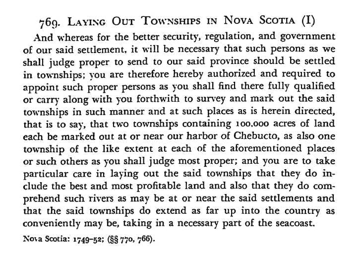
One result of the 1751 massacre was that a wooden wall was soon afterwards erected around the vulnerable sides of the town-plot, the same as had been done in Halifax. Mr. Piers in his writings, explains that these palisades or stockades consisted of stout trees, each six inches in diameter and about ten feet long, of which three feet were firmly embedded in the ground with the lower and upper parts spiked to a stringer. Their tops were sharply pointed in order to add to the difficulty of scaling.

This extensive work was done by German immigrants, who were allotted land outside the pickets. The course of the palisade probably ran from the area close to lot no. 1 of Block “E” which is near the Mayfair Theater and was then a stretch of meadow. It no doubt followed the soft earth around to the northeast corner of Block “I”. Dr. MacMechan’s account says that there was a series of four stockades.

Most likely many inhabitants were scared out of Dartmouth after the massacre, but there is evidence enough in the records to show that the village was not altogether abandoned, as has been repeatedly asserted by various writers.

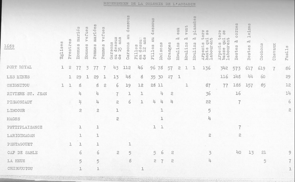
On St. Paul’s register for May 13th, 14th and 15th, 1751, there is an unusually long list of burials of soldiers and civilians. Among them is the father of John George Pyke who was definitely among the victims of the May massacre at Dartmouth which is thought to have taken place on the night of the 11th.

By 1800 there were many still living who vividly remembered the 1751 massacre. The child described here as having escaped the fury of the [Mi’kmaq] was very likely John George Pyke, who became a member of the House of Assembly and was for many years afterwards a police magistrate of Halifax at the old Court House just up the George Street slope from the ferry landing. His parents had come from England with the first settlers to Dartmouth, and were among the victims of the massacre in 1751. John George Pyke was then about six years of age. Pyke died at Halifax in 1828, where he had been Police Magistrate from the previous century. He was in his 85th year. Mr. Pyke’s figure was a familiar one, clad in drab colored knee breeches with grey yarn stockings and snuff colored coat, sitting in the little police office at the old Court House just up George Street from the Halifax ferry landing.

Many narratives of our early years give one the impression that Dartmouth was a ghost-town from the massacre days until the arrival of the Quakers. But soldiers kept coming and going, and civilians enough remained to create new excitement a few months after the spring [indigenous] raid. In October there occurred a small riot.

The fracas started when Walter Clarke, whose inn stood near the location of the Bowling Academy on Portland Street according to the chart, had an encounter with *John W. Hoffman, a J. P., who had been sent over from Halifax by Commissioner of Peace Ephriam Cook to investigate charges against Clarke; and if necessary take him into custody. So says the Court records.

Clarke was overseer of the German picketers, and perhaps boarded them at his tavern, because the account states that he had them cutting wood and carrying it to the beach on Sundays.

[Clarke] is the man charged with being the chief actor in the Lunenburg riot of 1753 and later imprisoned on George’s Island.

Court records of that time list the complaints of the Germans against the accused of:

1—Struck German people without reason.
2—Obliged the German people to work for him on the Sabbath Day.
3—Employed people to shingle his house on the Sabbath.
4—Employed German carpenters paid by the King, to finish his house, as if the work was done for the King.
5—Sold liquors on the Sabbath.
6—The Constable has found last Sunday his son cutting pickets before his house.

The military ruler of Dartmouth evidently sided with Clarke, for another Court record has a complaint of Mr. Hoffman against Ensign Francis Gilbert of His Excellency Gov. Cornwallis’ Regiment, on October 14, 1751, as follows:

“Hoffman was charged with a letter by Ephriam Cook, Esquire, for Mr. Gilbert—he delivered the letter, then Gilbert called me back saying, Mr. Hoffman, stop, whereupon I stopped, and he asked me what business have you here in Dartmouth. I answered that he had no power to make such a question to me; then he said to me, G- D- you, I will show you another way . . . Then he ordered five soldiers to take me in arrest, carried me as a criminal through *all the town of Dartmouth and I passing in that manner a house, where German people is living in, and Mrs. Clarke, the wife of Walter Clarke standing in the outside of the house, I heard a man’s voice and her loud crying and laughing at me, and I asked her if she did laugh at me, she answered yes, I do, because I see you a prisoner . . . Then I was obliged to go along with the soldiers who kept me in their custody longer than an hour till I was in the boat.”

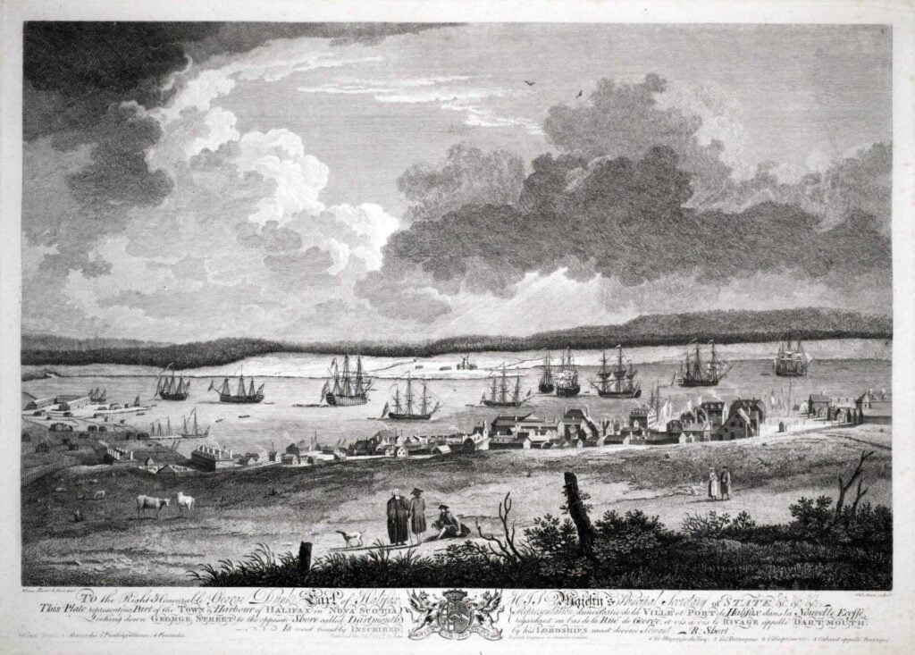
All the rocky elevation of that vicinity extending over to Christ Church cemetery was known as the “North Range”, because it marked the northerly limits of the town plot as originally laid out in 1750. The highest part of this slate rock ridge is in the rear of 98 King Street, just above the Fire Station. On this strategic spot, commanding a view both towards the lakes and the huts below, was projected a military blockhouse for the protection of our first settlers. That height is known as “Blockhouse Hill”.

Around that section known as “North Range” is woven much of Dartmouth’s recorded history. Shipyard Point seems to have been the front part of the original town plot, because Portland Street in the 1700’s was known as Front Street. The back part was the Blockhouse Hill ridge which extends easterly almost to Pine street. As it was from the lake district that [indigenous] attacks were spared, a barricade of spruce trees had been lined up by the inhabitants to fence off their settlement and to entangle the enemy.

Instead of being an obstacle, however, the brush palisade served as cover for the Mi’kmaq warriors when they made a murderous raid on the town in the month of May 1751. This assault inspired Governor Cornwallis to take further precautions, and as a consequence there was an order issued a few weeks later that some newly arrived German settlers were to be landed in Dartmouth, employed “in picketing the back of said Town”.

No doubt part of this picket protection curved down near the back of Christ Church cemetery. This was our first graveyard, for it was used by the families of the Nantucket Whaling Company as back as the 1780’s, and is often referred to as the “old Quaker burying Ground”. Evidently it was then outside the town plot. The lower part of the present cemetery contained a swamp which was covered with water most of the year, according to records from the Quaker days. A large oval-shaped reservoir which used to fill the hollow opposite 40 Park Avenue, probably formed part the pool. The flow of this sluggish water was easterly, and its run can be traced through the cemetery depression and Pine street to the lower part of Myrtle Street, where it curved down Maple Street to Join Saw Mill river running towards Mill Cove.

Thus it is seen that the first town plot of Dartmouth was a peninsula and triangular in shape, with “North Range” as the base line and Shipyard Point as the apex.

Ponds like the Park reservoir teemed with wiggling pollywogs and greenish frogs that croaked all through a midsummer night. Percy F. Ring got a severe bite from a muskrat that he had trapped there 50-odd years ago. Town authorities had a large puncheon sunk into the center of this pool to keep mud out of the hose of the “Lady Dufferin” whenever a fire occurred in that neighborhood.

1750

dartmouth royal instructions 1749

From The Story of Dartmouth, by John P. Martin:

After the Treaty of Utrecht, the first recorded proposal for a settlement on the Dartmouth side from British officials originated with Captain Thomas Coram of London in 1718. One of the districts selected for establishing colonists was “northeast of the harbor of Chebucto”. Massachusetts influence opposed this plan as being detrimental to their fisheries.

As an aside, Martin’s account of Captain Thomas Coram in 1718 and his attempt to establish settlements “northeast of the harbor of Chebucto” isn’t supported by “An historical and statistical account of Nova Scotia” by Thomas Chandler Haliburton, where it is stated that the settlement was instead planned for a location “upon the sea coast, five leagues S.W. and five leagues N.W. of Chebucto”, not on the Dartmouth side. (Five leagues is approximately 28 km). It did make me wonder about the “Bayer’s Lake mystery walls” and whether they are remnants of a such a settlement, made regardless of a lack of authorization from Colonial authorities.

When Hon. Edward Cornwallis set out to settle Halifax in 1749, he carried a complete plan of the harbor, the Basin and the surrounding shores, which had been previously surveyed by British Admiral Durell. The latter’s information about useful places on the eastern side must have been noted, and probably soon inspected by Cornwallis, for he does not lose much time in sending men over to the present Canal stream with the necessary gear to erect the sawmill.

Cornwallis also carried with him royal instructions that called for the founding of two townships “…containing 100,000 acres of land each be marked out at or near our harbor of Chebucto”.

There were about 30 men quartered at the sawmill during the winter of 1749-1750. More were living aboard the “Duke of Bedford” and on an armed sloop, which were anchored in the Cove nearby. It must have been an especially severe season, for the two ships were frozen-in so that ice had to be broken every night to prevent incursions from the shore.

Major Ezekiel Gilman was in charge of the sawmill. This pioneer local industry seems to have been an utter failure. In April 1750 Cornwallis reported to London that the mill had been his “constant plague from the beginning. We have never had one board from it”. This was partly due to Mr. Gilman’s bad management.

On the other hand, the Governor makes more encouraging reports on a second undertaking, presumably carried out on the eastern side of the harbor. In July 1750 he writes that “30,000 bricks have been burnt here which prove very good”.

Brick clay can still be clawed out of the sloping bank along the railway from Tupper Street to the Passage. Mott’s Pottery used tons of it. Until the 1880’s the Wellington brickyard flourished near the Seaplane base at Imperoyal. A record in the New York Public Library says that [Mi’kmaq] before going into battle, used to appear more ferocious by smearing their faces with “that red vermillion found on the east side of Chebucto”.

This clay belt must extend under the surface of downtown Dartmouth, because excavations at 85 Portland Street brought up quantities of plastic mud from the bottom of a 20-foot well, unearthed in the back yard.

The earliest accounts of the colonists destined to become our first citizens have been obtained from the Secretary of the Public Record Office in London. Their 1750 files disclose that the “Alderney” was getting ready to sail for this port from Gravesend on May 25. On July 6, she was reported at Plymouth, having put in there on account of contrary winds.

Evidently then, the pioneer settlers of Dartmouth sailed from the same English port as did the Pilgrim Fathers in 1620.

The actual day that the Alderney reached Halifax harbor is not definitely known. It was not before August 19, and not after the September 3rd, because Governor Cornwallis’ Council met on the latter date to select a location for the new settlers. The sites suggested were at the head of Bedford Basin, at the North West Arm, in the present Woodside-Imperoyal section and near the Saw Mill. The last mentioned was finally chosen. (The dates given are all old style. To conform to the present calendar, eleven days should be added).

The Alderney was a ship of 504 tons and the number of passengers on board totaled 353. No deaths were recorded on the voyage, mostly because immigrant vessels were by that time fitted-up with the newly-invented system of ventilation. The largest vessel among Cornwallis’ transports of 1749 was the “Wilmington” yet she carried only 340 colonists. Stretching space on the Alderney must have been very limited.

As a conjecture, the hold of the Alderney was also jammed with family heirlooms, household utensils, bedding, clothing, perhaps pet dogs, cats and parrots in the midst of seasick youngsters and oldsters inhaling the garlicky atmosphere so characteristic of old-time steerage accommodations. Hence, transatlantic voyages on these lurching and leaning sailing ships weren’t just exactly luxurious.

How our town came to be called Dartmouth is not definitely known. Dartmouth, England, was probably named for the first Earl of Dartmouth, George Legge the celebrated Admiral. He stood in high favor until suspected of treasonable correspondence with James II. Then he was imprisoned in the Tower for three months until his death in 1691.

William Legge, the second Earl of Dartmouth, was Keeper of the Privy Seal, and perhaps held that office in 1750 when he died. The late Harry Piers, who edited Mrs. Lawson’s History, says that our town was doubtless named after this man.

On the other hand, the name may have come from Dartmouth in Devon on the west coast of England. The 1950 guidebook of the latter town informs us that people from that district of the river Dart, migrated to Newfoundland from earliest times, probably to prosecute the fisheries.

Governor Cornwallis’ reports of 1750 indicate that he is anxious to obtain fishermen in order to make his colony self-sustaining. He hoped to have “people from the West of England next year for the fishery. Mr. Holsworth of Dartmouth sent people here this year, they have cleared ground to begin upon the Fishery next year”.

Dartmouth, England, guidebook states that the Holdsworth family occupied the post of Governor of Dartmouth Castle in hereditary succession until 1832. The descendants still live in Devon, according to recent information received from Mr. B. Lavers ex-Mayor of Dartmouth, Devon.

The town plan as laid out in 1750 comprised 11 oblong-shaped blocks, mostly 400 feet long by 200 feet wide. Each building lot was 50 by 100 feet. Reference to the cut shows that all the streets running north and south, lead to the Point, which is the front part of the settlement. The northern boundary seems to be the present line of North Street. The southern boundary is the present Green Street (once between Portland Street and Front Street), if it were produced through to Commercial St (present Alderney Drive). All the area from that line to the Point would be the 10 acre grant of Benjamin Green.

The eastern boundary is at Dundas Street, and from there the present Queen Street extends through the middle of the plot to Commercial St. But Portland and Ochterloney Streets come to an end at King Street. (No street names appear on first plan).

From that point all the way to Eastern Passage, larger areas ranging from 60 to over 200 acres, and fronting on the shore, were granted to people prominent among Cornwallis’ settlers. Adjoining Davison’s was that of Samuel Blackden (or Blagdon); next was John Salisbury at Hazelhurst shore, then Charles Lawrence in the Department of Transport vicinity; William Steele, Richard Bulkeley, Byron Finucane, Joseph Gerrish, Jacob Hurd, Charles Morris, Leonard Lockman, Rev. Aaron Cleveland, Rev. Mr. Tutty and others.

1749

Dartmouth land grant map

From The Story of Dartmouth, by John P. Martin:

Even before Dartmouth was settled, the authorities at Halifax planned for a sawmill and a guardhouse to be constructed on the eastern side of the harbor.

It was Major Gilman who erected the sawmill at Dartmouth Cove. It was likely situated on the stream which flowed from the Dartmouth Lakes (later, the Shubenacadie Canal), but the exact site is difficult to ascertain.

The land laid out for the sawmill appears under the name of Ezekiel Gilman in records of the time. The boundary of the plot began on the stream, at a spot about thirty chains (605 Meters, 0.38 miles) from Collins’s Point (King’s Wharf), near the Railway. From there it ran north 65° east, about sixty chains (1210 Meters, 0.75 miles); then north 35° west for about forty-two chains (845 meters, 0.52 Miles); then south 55° west, for seventy-two and a half chains (1460 Meters, 0.91 Miles); then south 35° east, for about fifty chains (1005 Meters, 0.62 Miles) until it reached the stream mentioned previously. This encompassed the lower half of Lake Banook, and the land to the south and southwest of it to the harbor.

066-1024x790
A general idea of what would have been Gilman’s plot
A “Major Gilmot” noted here on “A plan of the harbour of Chebucto and town of Halifax” from 1750.
dartmouth 1750

The 30th day of September 1749 was a harrowing day for Dartmouth when a major attack against Cornwallis and his men took place.

Early on that Saturday morning, six men were felling timber in an area about 180 meters from the old Dartmouth mill on Canal Street. They were suddenly attacked by Mi’kmaq who had been lurking in the thick forest nearby. It was the season of Michaelmas (the feast of St. Michael, September 29), when the nights grow longer and blacker. The Mi’kmaq had no doubt crept down from the lakes in the cover of darkness.

Four men were killed in the “‘”Mill Cove Massacre”‘”, and a fifth man carried up-country as a prisoner. The sixth one escaped, because he was probably out of musket range, he was able to get back to the Dartmouth mill where Major Ezekiel Gilman and his guards were stationed.

Governor Cornwallis had long feared an attack on his colonists, but not from the Dartmouth side. He had recently received information that the Mi’kmaq were designing to besiege the settlers at Halifax during that first winter.

The Mi’kmaq had been friendly when the transports came in June, but afterwards began to withdraw. On September 11, 1749, the Governor wrote to the home government that “Not one [Mi’kmaw] had appeared at Chebucto for some weeks past”. This was most unusual.

Then reports reached him that the Mi’kmaq were becoming hostile. At Canso in August, they took twenty English prisoners. Later at Chignecto another attack on some merchant vessels, and three dead crew. This event moved the Governor to take extraordinary precautions.

Accordingly, he ordered Captain John Gorham and his rangers to take up winter quarters in Bedford at a post which later became Fort Sackville. Halifax was well guarded at the front entrance.

But, as Historian Thomas H. Raddall points out, Cornwallis failed to realize that there was also a back entrance to his settlement.

This was by way of the river and lakes from Shubenacadie to Dartmouth, a traditional route used by Mi’kmaq for millennia – likely the route used for the Mi’kmaq assault, canoes beached at the foot of Lake Banook.

The assault occurred about seven o’clock in the morning. Two musket muzzles belched out first, and then a deadly volley spurted from the guns of the assailants.

When the soldiers from the Mill found their four dead comrades they saw that two of them had been decapitated, and their heads had been carried away. A third victim had been scalped. A pursuing detachment eventually killed two of the Mi’kmaq warriors. These men they promptly scalped, probably for the bounty.

In the collections of the N.S. Historical Society for 1892, there is a contribution by Miss Elizabeth Frame of Shubenacadie on the incident. It is an account written by one of the New Englanders living in Halifax and published in a Boston newspaper of 1749:

“Halifax, October 2, 1749 – About seven o’clock on Saturday morning before, as several of Major Gillman’s workmen with one soldier, unarmed, were hewing sticks of timber about 200 yards from his house and mills on the east side of the harbor, they were surprised by about 40 [Mi’kmaq], who first fired two shots and then a volley upon them which filled four, two of whom they scalped, and cut off the heads of the others, the fifth is missing and is supposed to have been carried off. Two or three men at work near the mill made their escape to a wooden planks—on one side of the Major’s house. As soon as he was alarmed he called in all his people and a party of 12 soldiers into his half finished blockhouse, fired his guns into the woods among them, and awaited their attack which they did not make, although they might easily have carried the place.”

During the winter of 1749-50, the storeship Duke of Bedford and an armed sloop were anchored in Dartmouth Cove, and the ice was broken around them every night in order to prevent an approach by the Mi’kmaq.

They were within “Gun Shot of the Fort at the Sawmill.” (Minutes of Council, Sunday, 7th January, 1750). The ships were under cover of a gun which was mounted on a point near the sawmill. This was likely Collins’s Point [-now “Kings Wharf”]. In June, 1752, the government mills at Dartmouth were sold at auction, for £310, to Major Ezekiel Gilman.

The story was also explored more recently, in 1944 by Thomas H. Raddall. It focused on the prior and the subsequent adventures of the captured Mill Cove wood-cutter of Major Gilman’s party, “Roger Sudden.”

Location of the “Government Mills” seen here, near the location of what would be “Marine House” at five corners today.

See Also:

Settlement previous to 1749

census 1688

From The Story of Dartmouth, by John P. Martin:

Dartmouth, long before the European explorers and colonizing forces, had a 7,000 year history of occupation by the [Mi’kmaq]. The [Mi’kmaq] annual cycle of seasonal movement; living in dispersed interior camps during the winter, and larger coastal communities during the summer; meant there were no permanent communities in the Euro-centric sense, but Dartmouth was clearly a place frequented by [Mi’kmaq] for a very long time. Whether it was the Springtime smelt spawning in March; the harvesting of spawning herring, gathering eggs and hunting geese in April; the Summer months when the sea provided cod and shellfish, and coastal breezes that provided relief from irritants like blackflies and mosquitos, or during the autumn and its eel season; Dartmouth with its lakes and rivers, both breadbasket and transport route back and forth to the interior, was a natural place for the [Mi’kmaq] to spend their non-winter months.

A fascinating look into what Nova Scotia and Atlantic Canada could’ve looked like, from the end of the ice age at 19,000 BCE, until present. By 12,000 BCE, this model shows Cape Cod extending much further into the ocean than it does at present, along what is now Brown’s bank, a ridge which more or less stretches all the way to Sable Island along the continental shelf. A sea level 300 feet lower than it is today was enough to create a kind of land bridge to the parts of western and central Nova Scotia no longer under ice, the Bay of Fundy looking like it was an inshore repository for glacial meltwater until sea levels rose. This could’ve allowed for human exploration and settlement in what is now known as Nova Scotia previous to the retreat of the ice sheet in full.

By 10,000 BCE most of the ice had retreated, which squares with the earliest artifacts found in the area, such as at Debert, which date to the same general period, if not previous to that. That sea levels had risen one hundred feet in this two thousand year period might be instructive as to why artifacts are few and far between from this period, many of the settlements, if coastal, would have long ago been lost to the sea. Assuming the artifacts found (at Debert and Belmont) were not from nomadic hunters, and that this model is somewhat accurate, Nova Scotia could have been settled for 10,000 years or more.

Source: https://web.archive.org/web/20210807155606/https://sos.noaa.gov/catalog/datasets/blue-marble-sea-level-ice-and-vegetation-changes-19000bc-10000ad/, https://web.archive.org/web/20130219202242/https://sos.noaa.gov/Docs/bluemarble3000h.kmz

A census of the district of Acadia taken in 1687-1688 attributed to de Gargas shows Chebucto had 1 French family consisting of a man, wife and son; that there were 7 Mi’kmaw men, 7 Mi’kmaw women and 19 Mi’kmaw children, “36 souls” in total. 1 French house, 7 Mi’kmaw homes, 3 guns, 1/2 acre of improved land.

census 1688
Source: https://dalspace.library.dal.ca/bitstream/handle/10222/15754/MS-6-13A1_DeGargas_Census.pdf?sequence=1
carteacadie6 map
“Chibouctou: https://cityofdartmouth.ca/carte-particuliere-de-la-coste-daccadie/
Source: “Recensements d’Acadie (1671-1752)”, (info), http://139.103.17.56/cea/livres/doc.cfm?livre=recensements, http://139.103.17.56/cea/livres/doc.cfm?retour=R0231&ident=R0040

The St. Malo fishermen who were located at Sambro and at Prospect in the days of French ownership, must often have run to the inner harbor either to dry fish on our long beaches, or to barter furs with the natives who were always their allies. On the Dartmouth side of the harbor, geographical conditions were far more favorable for congregating, with three voluminous streams of never-failing fresh water flowing down to the estuaries of the two little bays, both later known as Mill Cove.

Besides that, there was an abundance of shell fish available at low tide, along with lobsters, crabs, sea-trout, salmon, halibut, codfish, and haddock, with the usual runs of herring and mackerel in warm weather. The woods teemed with wild life. Partridge roosted on trees, moose and deer roamed the forest, and wedges of wild fowl honked high overhead.

The evidence already submitted that the [Mi’kmaq] resorted to the Cove, is borne out by the description of Cobequid (Truro district) by Paul Mascarene about 1721, where he states that “there is communication by a river from Cobequid to Chebucto”. This Implies that the Shubenacadie route had long been in use. Engineer Cowie, after studying several harbor sites for Ocean Terminals a hundred years ago was of the opinion that Chebucto had been used as a trading post over a century before its permanent settlement.

In 1701, when M. Brouillan the newly appointed French Governor, came here from Newfoundland to rule Acadia, he went overland from Chebucto to Port Royal. This is in Murdoch’s History. Dr. Thomas H. Raddall, in his bicentennial story of Halifax, thinks that on this occasion, [Mi’kmaq] transported the Governor by the well-known canoe route of Dartmouth Lakes. (One can’t imagine a viceregal party trudging over a rough black-flied trail from Bedford to Windsor, or portaging through the shallow rivers of that section of country).

One of the early sketches of Dartmouth side is preserved at the N.S. Archives. It is a detailed drawing of the whole shore and harbor, showing the depth of water from the Eastern Passage to the head of the Basin, done by the French military engineer De Labat in 1711.

The indentations of the various inlets seem quite accurate. The soundings must have occupied a full summer, and the work was no doubt done from small boats; otherwise his large vessel would have butted such shoals as Shipyard Point and the one off shore at Queen Street.

dartmouth map

Not sure whether this is the 1711 map Martin attributes to De Labat but it is detailed, especially as it relates to the Dartmouth Cove, and it contains a number of soundings as he describes. From: “Plan de la rivière de Seine et en langage accadien Chibouquetou” http://gallica.bnf.fr/ark:/12148/btv1b53089940v/f1.item.r=halifax.zoom

Page 33 of 33
1 30 31 32 33