“Dartmouth (5000), about a mile from Halifax, across the harbour, has a fine situation, and is a beautiful residential town, especially in the hilly and lake section back a little from the harbour. It has various manufactures, as sugar refining and making of rope and skates. The provincial Lunatic Asylum is in the neighbourhood of the town”
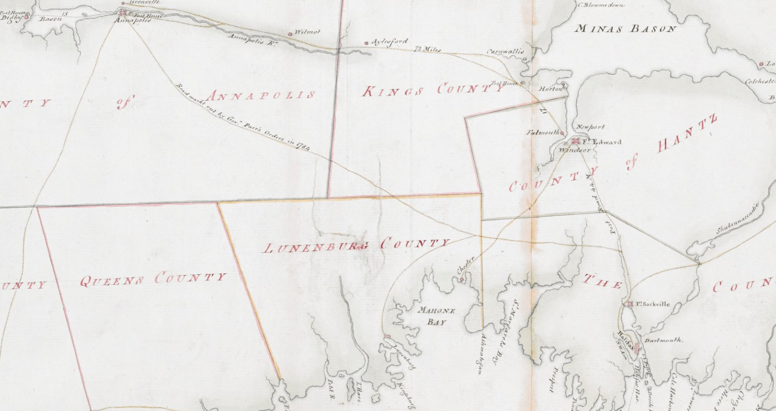
After piecing together several Crown land grant maps, you can see the path of the Old Annapolis Road much more clearly. Open the image in a new tab, to see it in more detail.
Below you’ll find a few representations of the road as a contiguous route, as opposed to what is left recorded on the Crown Land Grant maps. (You can find find the individual Crown Land Grant maps here: https://novascotia.ca/natr/land/grantmap.asp)
Previous to the construction of the more direct route to Annapolis, this map from 1776 shows a road (from Dartmouth, certainly an error, likely from Fort Sackville at the head of the harbor) to Annapolis. “A general Map of the northern British Colonies in America which comprehends the province of Quebec, the government of Newfoundland, Nova Scotia, New England and New-York” https://gallica.bnf.fr/ark:/12148/btv1b8443126p
One of the first representations of the Old Annapolis Road, “Road markt out by Gov. Parr’s orders in 1784”
“The Provinces of Lower & Upper Canada, Nova Scotia, New Brunswick, Newfoundland & Prince Edward Island with a large section of the United States”, 1831. https://gallica.bnf.fr/ark:/12148/btv1b530987207
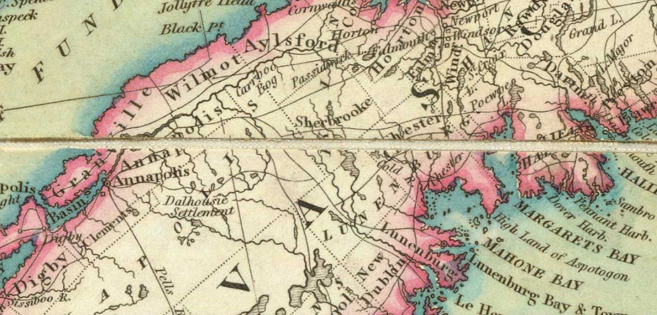
Annapolis Road pieced together from several pages of the “Atlas of the Maritime Provinces of the Dominion of Canada”, Roe Brothers, St. John, NB 1878. https://www.islandimagined.ca/roe_atlas
Fifteen years later, by 1927, the Old Annapolis Road disappears from the maps. Perhaps it wasn’t fit for automobile travel, though it’s hard not to notice the change (back?) to “Annapolis Royal” from “Annapolis” occurred at the same time.
Much of the road is now incorporated into other routes. It’s the #8 from Annapolisthrough Lequille, it’s the West Dalhousie Road through to Lake La Rose and from West Dalhousie to Albany Cross on to Stoddard’s where it once continued straight at what is now a turn (see above at 1876). It then crossed over the brook that empties into Upper Thirty Lake, from there it continued across another bridge, this time over the LaHave River to connect to what is now Camel Hill Road. The route proceeded to where it now meets Cherryfield Road and becomes Dalhousie Road, and on eastwards from there, through to Franey Corner and on to New Ross. At this point the route seems to have been reclaimed by the woods somewhat but it continued south and east near Sherwood, and then north of Canaan and Timber Lake, to the south of Panuke Lake (once called “Carrying Place”, see above at 1864) near Simms Settlement, through the country between Sandy and Rafter lake then terminating at Pockwock Road, north of Wrights Lake in Upper Hammonds Plains.
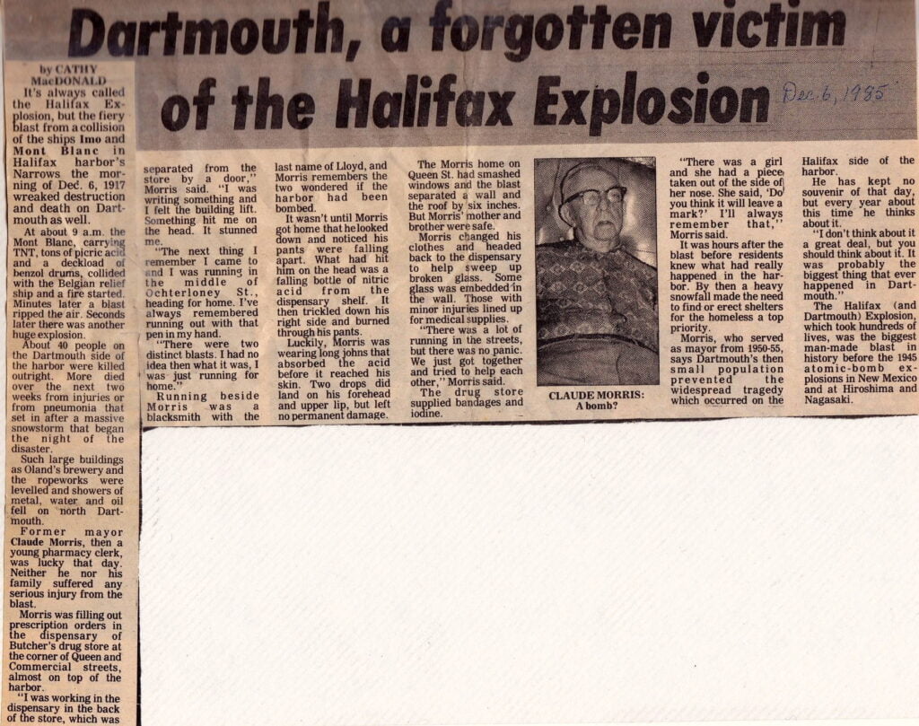
“It’s always called the Halifax Explosion, but the fiery blast from a collision of the ships Imo and Mont Blanc in Halifax Harbour’s Narrows the morning of Dec. 6, 1917 wreaked destruction on Dartmouth as well.
About 40 people on the Dartmouth side of the harbour were killed outright. More died over the next two weeks from injuries or from pneumonia that set in after a massive snowstorm that began the night of the disaster.
Former mayor Claude Morris, then a young pharmacy clerk, was lucky that day. Neither he nor his family suffered any serious injury from the blast. “There were two distinct blasts. I had no idea what it was, I was just running for home.” Running beside Morris was a blacksmith with the last name of Llyod, and Morris remembers the two wondered if the harbor had been bombed.”
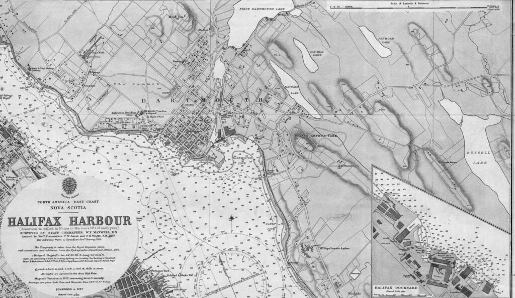
From: Halifax Habour, Surveyed by Staff Commander W.F. Maxwell, R.N., Assisted by Staff Commanders F.W. Jarrad and P.H. Wright, R.N. 1889. The Narrows from a Canadian Government Survey, 1916. The Topography is taken from the Royal Engineers plans, with corrections and additions from the Hydrographic Department, Ottawa, 1916. Soundings in Feet, Natural Scale 1/10,560.
“The Telephone Utility is one of the oldest and largest public utilities, and perhaps the one which comes into direct contact with the most people in their workaday lives. The telephone was invented in 1876 by Alexander Graham Bell, a man well and favourably known in Nova Scotia, as during the last years of his life he made his home in Cape Breton, just outside of Baddeck. The first telephone in Halifax was installed in 1877, and the first actual commercial use of the service was at the Caledonia Mine, Cape Breton, also in the same year. At this time the receiver and transmitter were not separate, but the same instrument was used for both, being changed back and forth from ear to mouth. In 1878 the first long distance call in Nova Scotia was placed from Halifax to Truro. In 1879 the first switchboard to connect the different lines in Halifax became necessary. It was located in an office on Hollis Street. No directory was issued until 1880, and the first one carried the names of 77 subscribers. A submarine cable was laid across Halifax Harbour in 1881 to provide direct Halifax connections for Dartmouth users.”
“The Town of Dartmouth first had continuous 24 hour electric service when the cable was laid crossing the Halifax Harbour in June, 1916. Rates at this time were 12 1/2 c. net per kilowatt hour for general lighting service. In 1917 these rates were reduced by 20% or 25% where a contract was signed for five years. In 1927 the Board’s standard form of rate was adopted in Dartmouth, and for residence service was 3c. per hundred square feet of floor area, 7c. per kilowatt hour for the first block, 2 1/2 c. per kilowatt hour for all excess (same as in Halifax). The next rate change was in December 26th, 1929, when the cost of current for the first block was reduced from 7c. to 5c. per kilowatt hour and all excess remained as in Halifax, at 2 1/2 c. It is the duty of the Board to see that all reasonable extensions in the public utility service are made, and this has been done in many cases in the last few years by agreement with the Public utility, and sometimes after public hearing.”
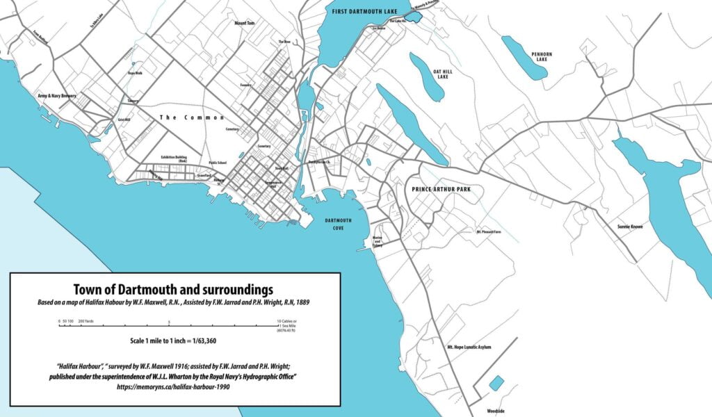
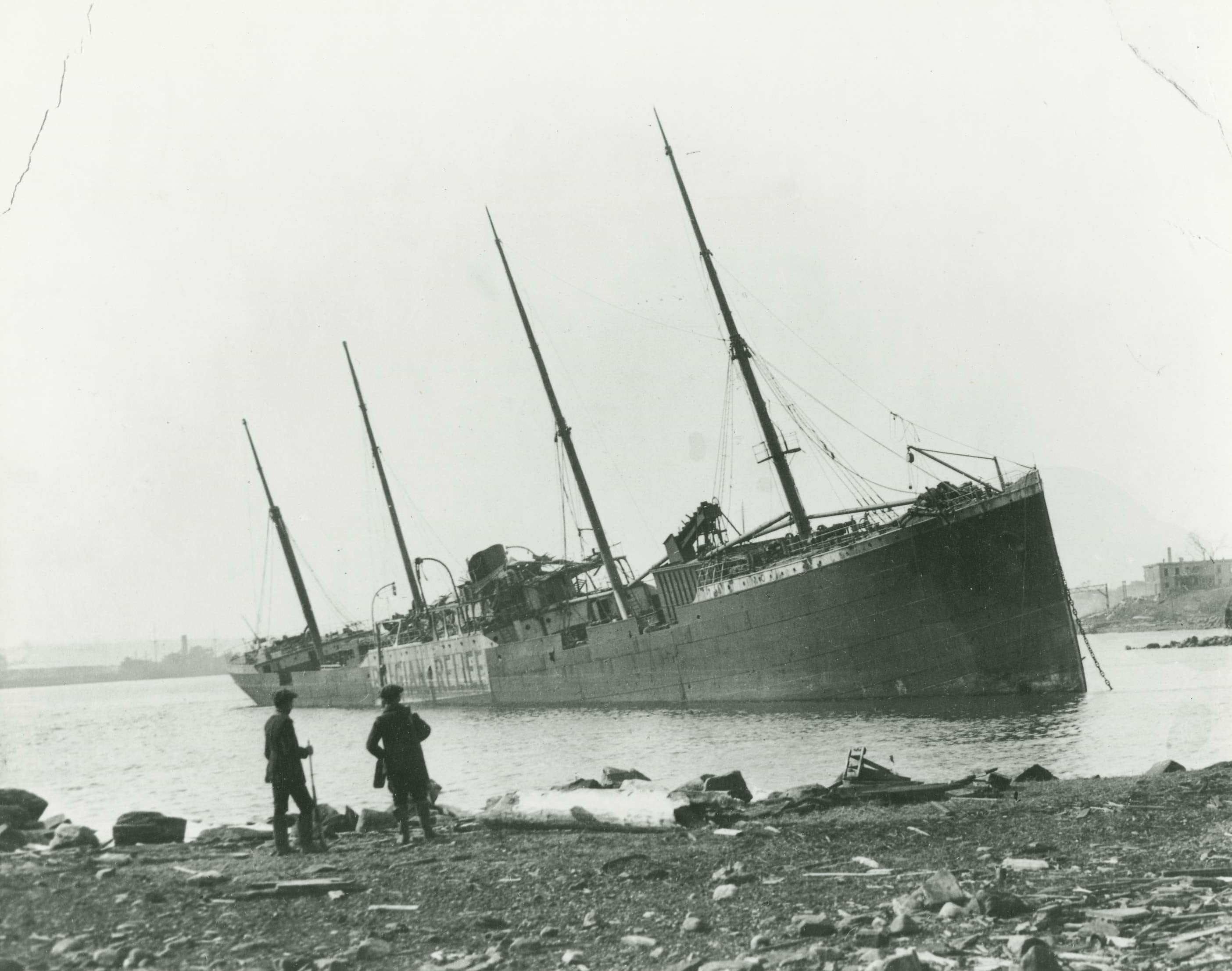
Christmas sight of 1917 at north Dartmouth, looking down the harbour. This is the ill-starred “Imo”, flung somewhat parallel to the shore, with her starboard side canted towards Halifax. The stump of the smokestack is seen slanting up from the twisted mass admidships. Holes in the stem and stern, flooded the steamer to the water level.
Pinned on bottom under the “Imo’s” bow could be seen the remains of Walter Meredith’s 27-foot motor-cruiser. Tidal waves deluged all level lands to the left of the railway. “Imo” survivors afterwards declared that they were unaware of “Mont Blanc” cargo.
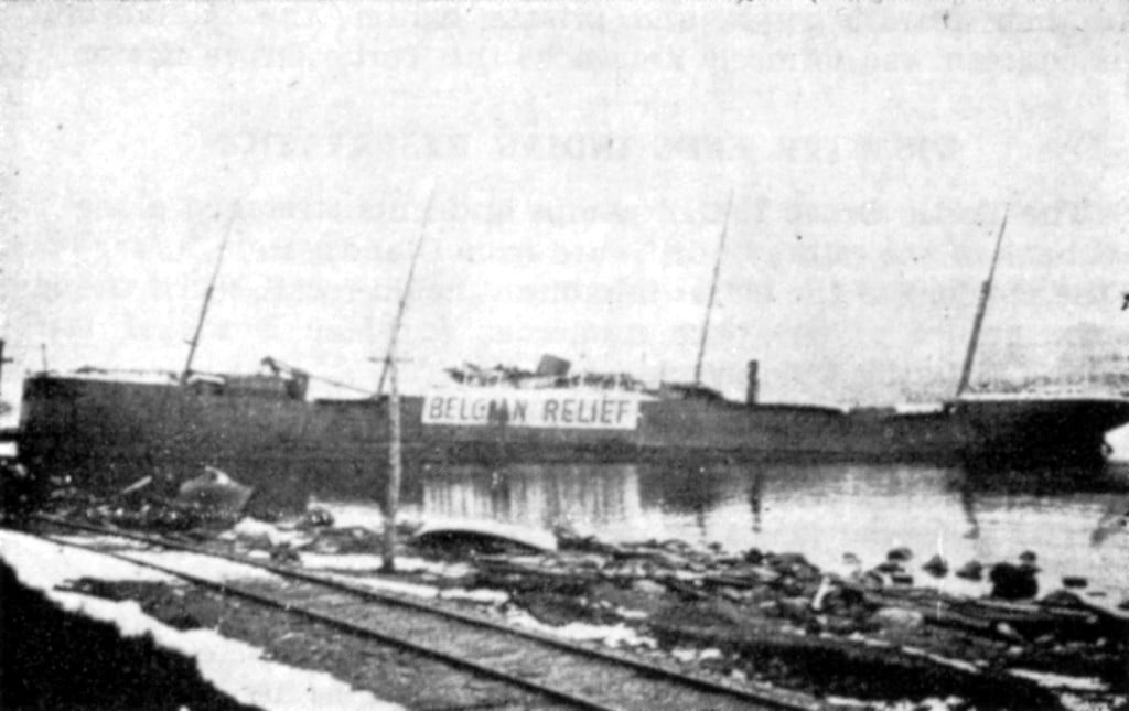
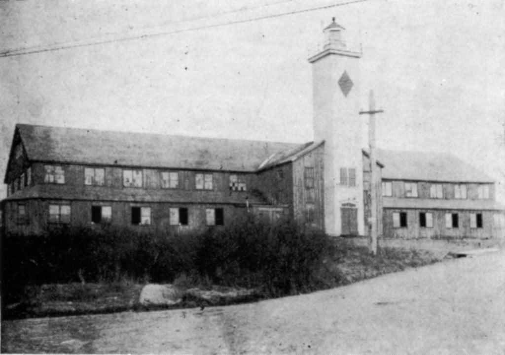
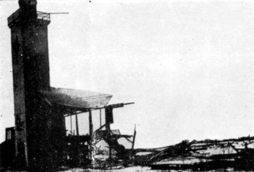
This was Dartmouth’s first rink built entirely of spruce at a cost of $3,800. Its dimensions were 190 feet by 65, with an ice oval of 175 feet by 50 feet. It was the home rink of the famous Chebucto Amateur Athletic Club, Maritime hockey champions from 1887 to 1894.
Electric lights flooded the entrance on the grand opening of September 29, 1884, when 2,000 people crowded the building for an evening musical concert. Over the original tower fluttered colored flags and streams of bunting.
The new lighthouse section was inserted in 1903. In 1907 the light was removed to is present position on Synott’s Hill.
This local leaning Tower of Pisa was all that remained of wooden Dartmouth rink after the 1917 explosion. Standing as it did on the hilltop, without any sheltering houses on the east side of Windmill Road, the old rink was directly in the path of the terrific concussion that swept down from the Narrows. In pre-movie winters, the rink was a nightly mecca.