“The 1999 Halifax Regional Municipality (HRM) Citizen Survey is used here to study citizen responses to a municipal amalgamation that created the Halifax Regional Municipality. The analysis of this survey brings forward citizen-based assessments of the amalgamation decision and subsequent municipal governance. Questionnaire items are used to create measures of citizens’ views concerning amalgamation, the relationship between the urban and rural spaces of the new municipality, the performance of the HRM political leadership and the impact of amalgamation on municipal services.
There are two key research questions. How did HRM citizens assess amalgamation after three years of experience? What factors best explain citizens’ views towards amalgamation? The political and policy context of the amalgamation decision taken unilaterally by the Nova Scotia provincial government is briefly described. In turning to the survey data, key variables are developed and then used in a model of citizens’ amalgamation perspectives.
The Context of Municipal Amalgamation in Nova Scotia
In 1991, the Nova Scotia Minister of Municipal Affairs initiated a Task Force on Local Government to balance the design and implementation of local government with provincial settlement patterns. The municipal reform objectives for the province were:
To preserve and develop vital urban centres with a wide range of services, including social, educational, commercial, cultural, governmental and recreational amenities
To deliver services to the communities of Nova Scotia based upon their needs, taking into account the differences in population, environmental circumstances and type of community
To achieve an equitable, effective and fiscally sound system of municipal government to deliver community services (Nova Scotia 1992)
This Task Force continued a discussion of municipal reform that had been on-going since the 1970s which began with a royal commission on education, services and provincial-municipal relationships (Nova Scotia 1974). This most recent stage, however, moved from word to deed. The Nova Scotia government passed legislation which amalgamated the communities of industrial Cape Breton (Nova Scotia 1995a). Reflecting on their accomplishment and the lack of immediate, negative political consequences, the government did the same for the Halifax region (field interviews, Nova Scotia 1995b).
At the time, proponents of amalgamation argued that this effort would decrease the over-all cost of government, improve the quality and level of services, improve regional planning and strengthen economic development by reducing competition between the four municipalities which were consolidated by the legislation. The Municipal Reform Commissioner’s Interim Report (on amalgamation) boldly projected efficiencies in both the delivery of services and their administration (Hayward 1993).
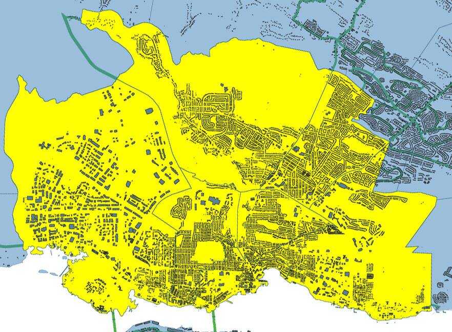
The single-tiered Halifax Regional Municipality (HRM) was created 1 April 1996 with the amalgamation of four municipalities — the Cities of Halifax and Dartmouth, the Town of Bedford and the Municipality of the County of Halifax — and the elimination of the Halifax Regional Authority. The new municipality consists of almost 2,500 square miles and brings together an urban core, suburban neighbourhoods and “big box” shopping centres with small communities, villages, farm land and wilderness. It is diverse in its economy and geography. The regional economy includes the financial centre of the Atlantic region, six universities, the provincial capital, a container port, the Canadian Navy, lobster fishing and dairy farming. Its population density, if expressed as an average, would be completely misleading. Still, most areas within the region are part of a shared social and political life and economy. The amalgamation began in a context of conflict between the provincial and municipal governments and was implemented without municipal consent through legislation by the Nova Scotia government (Nova Scotia 1995b)
“Since the late 1950s there has been an explosion of residential development within the commuter belt of Halifax, Nova Scotia. This city region is unusual in having very little farming or pre-existing settlement, so that land prices are low, and development controls have been minimal. Conversely, however, the predominantly hardrock environment presents severe difficulties for the extension of sewer and water lines, and has thus constrained the growth of serviced residential subdivisions. This paper documents the regional progression of both suburban residential development, which is generally serviced, and exurban or country residential development (CRD), which is generally unserviced.
The author’s aims are, first, to describe the locational sequence of peri-urban residential development in the Halifax city region over the 40-year period 1960-2000. Secondly, to analyze and explain that sequence in terms of three sets of factors: magnets or attractors for residential development, constraints or inhibitors, and planning policies designed to control or direct development. Thirdly, to identify lessons from the past which suggest useful policy options for planning of future residential patterns. An assessment of past development processes and current options is particularly timely, since the region’s four municipal units (the cities of Halifax and Dartmouth, the town of Bedford, and the Municipality of the County of Halifax) amalgamated in 1996 to form the Halifax Regional Municipality (HRM–see Millward 1996, 12-14). This regional government now stands ready to prepare a new land-use and transportation plan for the region.
While Halifax’s special environmental circumstances have produced a pattern of development which is unique in its particulars, many of the driving factors operative in the Halifax region are also actively or potentially operative throughout the developed world. The lessons from a detailed case study should therefore have considerable transferability, particularly to other city regions possessing high personal mobility in combination with low rural land valuations. Halifax allows an exceptionally clear view of the dramatic effects of automobile-induced commuter development, since its hinterland was remarkably devoid of resource-based settlement prior to 1950, there are no alternative urban employment centres within commuting range, rural land prices are extremely low, and competition or conflict between housing and resource industries has been minimal. The combined effect of these conditions is that pre-1960 housing within the commuter-shed has been swamped by post-1960 development, both in suburban and exurban areas. The paper also has wider relevance in that it highlights the local importance of broad shifts in styles of governance and planning philosophies. These shifts occurred worldwide after 1980, and the Halifax case illustrates the impact of policy and funding changes on the promotion and control of peri-urban residential development.
The Regional Situation to 1960 Halifax was founded as a fortress and naval base, not as the central place for a region of agricultural settlement (Millward 1993). Indeed, the physical environment almost precludes farming, being a forbidding land of glacially-scoured igneous and metamorphic rocks (granite, slate, and greywacke), poorly-drained, strewn with boulders, and lacking topsoil. Within the area depicted on Figure 1, only a few areas had sufficient depth to bedrock to enable settlement for semi-subsistence farming (Canada Land Inventory classes 3 to 5): these are the softrock environments to the north and a discontinuous area of drumlinized glacial till extending from Halifax east to Chezzetcook. Glacial till also enabled small pockets of farming in the Sackville river valley at Hammonds Plains, and on the north-east margins of St. Margaret’s Bay. Elsewhere the interior remained virtually unsettled through to 1960, with the exception of several Black communities–North Preston and Beechville (near Lakeside)–which began life as subsistence farming communities despite their lack of topsoil (see Henry 1973; Pachai 1987/1990).”
“On 1 April 1996, the Nova Scotia government amalgamated the Town of Bedford, the cities of Dartmouth and Halifax and Halifax County to create the Halifax Regional Municipality. The Halifax amalgamation is one in a series of such mergers that have happened recently in Ontario, Quebec and the Atlantic Provinces. This study compares the costs, resources, service levels, crime rates, workloads and citizen perceptions of police services before and after amalgamation. The findings suggest that, overall, amalgamation of police services in the Halifax region is associated with higher costs (in real-dollar terms), lower numbers of sworn officers, lower service levels, no real change in crime rates, and higher workloads for sworn officers.
The findings from three citizen surveys that compare perceptions before and after amalgamation indicate that when the comparisons are focused on persons who actually called the police in 1997 and 1999, nearly thirty-two per cent of those surveyed in 1997 felt that police services had gotten worse since amalgamation, and nearly twenty-five per cent felt the same way in 1999. In 1995, thirty-nine per cent of survey respondents expected services to get worse with amalgamation. Claims about the efficiency and cost-effectiveness of amalgamations have tended to rest on evidence that is generally inadequate to assess the actual consequences of this kind of organizational change. The current study suggests that when predictions are tested, there is a considerable gap between the rhetoric and what actually happens when police departments are amalgamated in an urban setting.”
PREMIER MEETS WITH MUNICIPAL LEADERS


Premier John Savage said today his government is committed to working co-operatively with Nova Scotia municipal leaders in building a dynamic provincial economy.

The premier met this morning with the executive of the Union of Nova Scotia Municipalities and stressed the need for even greater cooperation between the two levels of government.

"Both levels of government want to see the economy grow and jobs created. We can best accomplish that by putting aside differences and working co-operatively towards a more prosperous Nova Scotia."

Premier Savage said he was aware of municipal concerns arising from the provincial government's efforts to get it's financial house in order.

"All levels of government must share the responsibility of getting spending under control. Gone are the days when we can solve problems simply by going to the bank and borrowing money."

Premier Savage told the municipal leaders that Ottawa budget cutting will mean hundreds of millions of dollars in lost revenue over the next four or five years.

"Ottawa is both reducing federal transfer payments and increasing fees for various services it provides. While we accept the fact that it's necessary for the federal government to get its finances in order, it nevertheless means a substantial loss to the Nova Scotia economy."

Premier Savage told the UNSM executive that the upcoming Nova Scotia budget will impact municipalities. However, the government is working to soften the blow as much as possible.

The premier said he was encouraged after today's meeting with the municipalities.

"The municipal leaders have an obligation to fight for their taxpayers. We respect that. But we are also pleased with their willingness to work co-operatively with the provincial government"

Municipal Affairs Minister Sandra Jolly also attended today's meeting.


Feb. 09, 1996 4:45 p.m.
Community Services Minister Jim Smith said today that he was hopeful that the new Halifax Regional Municipality would accept the offer to takeover delivery of all municipal social assistance programs on April 1, 1996. “It’s a good deal for the new municipality. At a time of federal budget cutting this plan fixes the municipal costs at predictable levels.” The pilot program will offer greater efficiency through full-service offices. “Right now someone needing assistance in Dartmouth travels to Young Street in Halifax for provincial family benefits and to the West End Mall for employment and training services. In the new system the client will be able to access all services in one location often in their own neighbourhood,” said the minister.
Other changes include standardized food allowances, and a new emphasis on job training and work experience. “We have to look at people’s abilities and potential as soon as they come into our system. We have to support and encourage people to find their place in the workforce,” said the minister. The pilot program moves the province closer to its goal of single-tier delivery of social services. “The takeover affords us with a golden opportunity. After April 1, 1996 we begin to harmonize rates and simplify rules for clients. At the same time we will begin a dialogue about the future of social services across this province. Losses in federal funding make this a priority,” said Dr. Smith.
Dr. Smith wants both levels of government to work together to protect services for Nova Scotians. “Over the last year my department has worked closely with municipalities across Nova Scotia. If we continue that kind of cooperation we will protect taxpayers and services,” he said. The province is also operating a pilot program in Cape Breton. Both programs will be reviewed to determine the best approach for a provincial single-tier system to deliver social assistance. Changes will be phased in. On April 1 most clients will see the same caseworker at the same location.
BACKGROUNDER
Provincial Family Benefits is intended for disabled adults or single parents, — people who require long-term assistance. Covers basics such as food, shelter and clothing. Fifty-six per cent of the caseload is disabled and 44 per cent is single parents. This program is delivered by the province through local offices. Municipal General Assistance is intended for persons in need of shorter term assistance. It provides for food, clothing and shelter. Also items of special need can be provided including: emergency dental, optical, medical equipment, etc.
This program is delivered by each municipality and varies in each municipality. The province and the municipalities also cost-share Home for Special Care, housing for people with disabilities, and in-home support. Many individuals in financial need, first access the municipal general assistance program. Many apply and must be assessed by the province for the family benefits program. Additionally a number of family benefits clients re-apply separately to municipal general assistance for special needs items. The whole process can involve as many as three applications and assessment processes.
After April 1, 1996, in the areas where single-tier delivery is being piloted, this type of bureaucratic duplication will be eliminated. In metro there are 17,000 people served by the dual system of short-term municipal general assistance and provincial family benefits. In addition people are supported by Homes for Special Care, housing for people with disabilities and in-home supports. The total cost of social assistance and related programs in metro in 1995 was $197 million. The province contributed $91 million in family benefits and its related Pharmacare program. The province also contributed $83 million toward the cost of municipal short-term assistance. That leaves the municipality with a net cost in 1995 of $23 million.
Under the pilot program the province is offering to fix municipal costs at the 1995 level. Services include food, housing, transportation and clothing as well as dental, optical and medical needs. There are programs offering job training, housing for people with disabilities and Homes for Special Care. There are 32,500 people in Nova Scotia currently receiving family benefits. There are 20,000 people currently receiving municipal assistance. The province has already piloting the take over social services in the Cape Breton Regional Municipality.
By initiating pilots in both metro and Queens the province will take responsibility for 65 per cent of the total municipal caseload. Most provinces moved to a single-tier system (provincial delivery) years ago during periods of healthier finances. Ontario, Manitoba and Nova Scotia still have two-tier systems.
MUNICIPAL AFFAIRS--REGIONAL MUNICIPALITIES BILL INTRODUCED

Nova Scotia municipalities who are considering amalgamation will soon have a legislative framework in place. Municipal Affairs Minister Sandy Jolly introduced a Regional Municipalities Bill in the Legislature today.

"This new legislation will be used only when requested by municipalities," said the minister. "It's voluntary. It's there when they choose to use it."

The Regional Municipalities Bill is made up of two divisions. The first contains definitions, a description on how the regional legislation is activated, and an outline of the rules to change municipal units to regional municipalities.

The second division contains provisions dealing with the organization, powers and responsibilities of a regional municipality. The majority of what is contained in this bill is taken from the Halifax Regional Municipality Act.

The minister outlined the process for future amalgamations. First, she said, there must be a study requested by one or more councils in a county. Second, there must be a request for regional government by a majority of the municipal units. The power to establish a regional municipality cannot be exercised unless the majority of the councils in a particular county request it.

"The province believes that municipalities have the interests of their communities at heart," the minister said. "They will move to regional government when it is shown to be advantageous."

The minister noted that studies have been requested, and are about to be undertaken, in Cumberland and Pictou Counties. Colchester municipal units have undertaken their own study.  A regional government will not be established in any of these counties unless requested, she said.

"Our goal is to create strong local governments that meet the needs of today's taxpayers in terms of their structure and their ability to pay, their ability to plan, and deliver services in the best way possible," the minister said.

The minister reiterated the benefits in amalgamation. Those benefits include less government, streamlined service delivery and more focused decisions.

Oct. 26, 1995
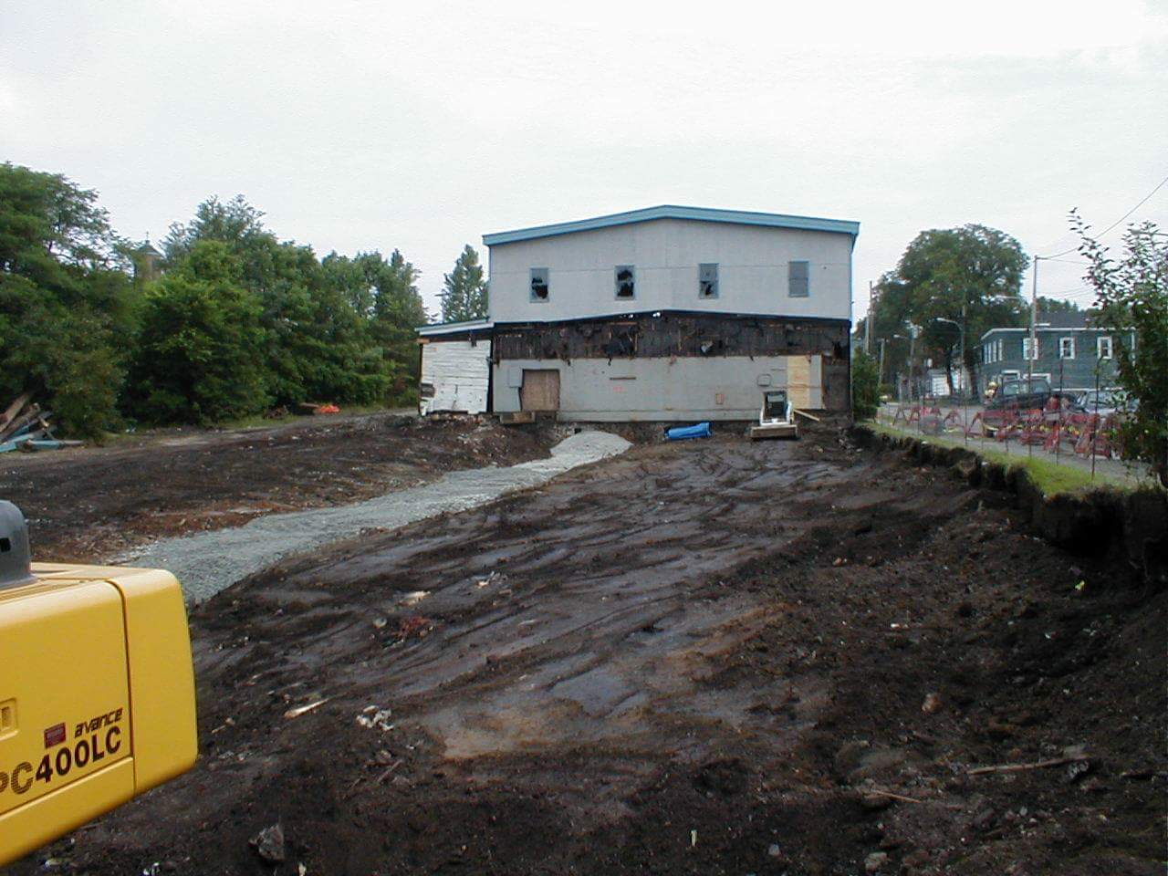
During demolition, the original route of the inclined plane is visible middle left; Looking north towards Pleasant at Prince Albert at extreme rightLooking South towards Pleasant Street (out of frame at left)Looking north towards Sullivan’s Pond
Looking north-east towards Prince Albert Road, inclined plane at left
An examination of the legislated spatial dimensions of Dartmouth – from its initial definition as a township care of the Royal instructions that accompanied Cornwallis in 1749 to its dissolution in one of Nova Scotia’s city county mergers by fiat (aka a “municipal coup”) in 1996.
“And whereas for the better security, regulation and government of our said settlement, it will be necessary that such persons as we shall judge proper to send to our said province should be settled in townships; you are therefore hereby authorized and required to appoint such proper persons as you shall find there fully qualified to carry along with you forthwith to survey and mark out the said townships in such manner and at such places as is herein directed, that is to say, two townships containing 100,000 acres of land each be marked out at or near our harbor of Chebucto, as also one township of the like extent at each of the aforementioned places or such others as you shall judge most proper; and you are to take particular care in laying out such townships that they do include the best and most profitable land and also that they do include the best and most profitable rivers as may be at or near the said settlements and that the said townships do extend as far up into the country as conveniently may be, taking in a necessary part of the seacoast”.
“That the Township of Dartmouth comprehend all the Lands lying on the East Side of the Harbour of Halifax and Bedford Basin, and extending and bounded Easterly by the Grant to the Proprietors of Lawrence-Town, and extending from the North-easterly Head of Bedford Basin into the Country, until One Hundred Thousand Acres be comprehended.”
“Common of the town of Dartmouth…the common of the township of Dartmouth; situate on the eastern side of the harbour of Halifax, in special trust, for the use of the inhabitants settled and resident in the town plot, or that might thereafter settle, and actually reside, within the township of Dartmouth… Within the township of Dartmouth”
Chapter 2 of the Acts of 1797, “An act to enable the Governor, Lieutenant Governor, or Commander in chief for the time being, to appoint Trustees, for the Common of the Town of Dartmouth, on the death, or removal, of the Trustees holding the same, and to vacate that part of the grant of the Common aforesaid, which vests trust in the heirs, executors or administrators, of the Trustees, named in the said grant, on the death of such Trustees” http://0-nsleg–edeposit.gov.ns.ca.legcat.gov.ns.ca/deposit/Statutes/at_large/volume1/1797.pdf
“Town plot of Dartmouth… The said town… The town plot of Dartmouth, bounded on the North by the Common, on the South and West by the Halifax Harbour, and on the east by Mill Brook… Of the said towns respectively, within the said limits.”
“the Town of Dartmouth… inhabitants of the said town… the jurisdiction, powers and authority, of the commissioners so to be appointed for the said Town of Dartmouth, shall be confined and restricted to the bounds and limits following, that is to say:— to the direction or space of one Mile, measured in a southwardly, Easterly, and Northerly direction, from the Public Landing, or Steam Boat Company Wharf, in the said Town.”
“Whereas some uncertainty exists as regards the limits of the Township of Dartmouth… Be it therefore enacted by the Lieutenant Governor, Council and Assembly, that the lines of the Township of Dartmouth shall be established and settled as follows, beginning on the Eastern side of Bedford Basin at the head of Pace’s cove at low water mark, and thence to run north seventy four degrees east until it meets the main stream running Into Lake Major, thence southerly through the center of Lake Major and West Salmon River to the waters of Cole Harbor and thence Southwestwardly along the shore the several courses of the shore to Roaring Point, thence northerly following the course of the shore of the Main Land at low water mark to the place of beginning, so as not to include any Islands lying on or near said shore.
“…the inhabitants of the said town of Dartmouth …within the space of one mile, measured in a southwardly, easterly and northerly direction from the public landing or Steamboat Company’s wharf in said town”
For Dartmouth…one mile, measured in a southwardly, easterly and northerly direction from the public landing or Steamboat Company’s wharf in the said Town”
“After the first Annual Town Meeting in the Township of Dartmouth, Three Trustees of Public Property shall be chosen, in whom shall be vested the legal possession of the several Water Lots that have been reserved for the use of the Public along the shores of the Town Plot of Dartmouth, and of a certain Lot of Land and School House now known and distinguished as the School Lot, lying in the Town Plot, to be recovered, held and preserved by the Trustees for the uses to which the same respectively have been reserved and applied, but the School House and School Lot shall be preserved exclusively to the use of Schools and Education, and nothing herein shall excuse the possession and control of the Trustees to be appointed under the Act passed in the present Session for the support of Schools if the School House and Lot might otherwise come under control of such Trustees. Any other Public Property in the Township of Dartmouth not legally possessed by or under the charge and supervision of any person, shall also be legally vested in the Trustees appointed under this act… three trustees shall be annually thereafter appointed at each Annual Town Meeting of the Township… The Inhabitants, in Town Meeting, at any time may declare the purposes to which the Town Property shall be applied by the Trustees, provided those purposes shall not be inconsistent with the uses to which the property has been granted, reserved or legally appropriated… the next Annual Town Meeting of Dartmouth”
“The rateable inhabitants residing within the town plot of the township of Dartmouth, in the county of Halifax, may assess themselves, at any public meeting… for the purpose of obtaining a good and sufficient plan of said town plot… the inhabitants of the said town plot… The Commissioner of Streets for the said township…”
“The Trustees of the Dartmouth Common shall be a Body politic and corporate… the Commissioner of Streets for the Town of Dartmouth… A requisition signed by two thirds at least of the rate payers residing within the limits of the town plot of Dartmouth… Which town plot shall be construed to embrace an area within a distance of one mile measured in a southwardly, easterly and northerly direction from the public landing or Steamboat Company’s wharf in said town”
‘A municipality shall be erected within the County of Halifax, to be bounded as follows, that is to say: Beginning on the eastern side of the Harbor of Halifax, at a point in such Harbor distant three hundred feet Westerly from the South Western corner of a lot of land formerly owned by Judge Johnston and by him conveyed to John Esdaile; thence to run Eastwardly till it strikes the road leading to the property of the late John Esson; thence by the Southern side of such road and following the course thereof Eastwardly to such Esson property; thence along the Western boundary of such property, Southwardly to the South-Western corner thereof; thence Eastwardly to Gaston’s Road, and crossing such road to a point at right angles with the extension of a new road laid out by J.W. Watt through manor Hill Farm; thence Northwardly to such road and by such road for the length thereof; thence Northwardly to the causeway at Hurley’s on the First Lake; thence Northwardly to the North East boundary of Stair’s Ropewalk property; thence Westwardly to a point three hundred feet into the Harbor of Halifax; and thence Southwardly to then place of beginning; to be called and known as “The Town of Dartmouth”‘.
The inhabitants of the town of Dartmouth are constituted and declared to be a body corporate and politic by the name of the Town of Dartmouth. They shall as a corporation have perpetual succession and a Common Seal, changeable at pleasure, and shall be capable of suing and being sued in all Courts of Justice, and of acquiring, holding and conveying any description of property, real, personal or mixed, and shall have all the other rights usually had and enjoyed by corporations.
The Town of Dartmouth shall be bounded as follows:—
Beginning on the eastern side of the Harbor of Halifax, at a point in such Harbor distant three hundred feet Westerly from the South Western corner of a lot of land formerly owned by Judge Johnston and by him conveyed to John Esdaile; thence to run Eastwardly till it strikes the road leading to the property of the late John Esson; thence by centre of such road and following the course thereof Eastwardly to such Esson property; thence along the Western boundary of such property, Southwardly to the South-Western corner thereof; thence Eastwardly to Gaston’s Road, and crossing such road to a point at right angles with the extension of a new road laid out by J.W. Watt through manor Hill Farm; thence Northwardly to such road and by such road for the length thereof; thence Northwardly to the western extremity of the causeway at Hurley’s on the First Lake; thence Northwestardly through Taylor’s barn on the opposite side of the lake until it strikes the Southern side line of the road which connects with the new road laid out by G. A. S Chichton, thence following the southern line of said road until it reaches the main road leading from Dartmouth to Bedford; and from thence crossing said road in a straight line following the said line of the said new road until it extends three hundred feet into the harbor of Halifax, and thence Southwardly to the place of beginning to be called and known as “The Town of Dartmouth”.
“The inhabitants of the town of Dartmouth are constituted and declared to be a body corporate and politic by the name of the Town of Dartmouth, and the boundaries of the town of Dartmouth, the division of the same into wards, and the boundaries of the several wards thereof, shall continue as at the passing of this Act.”
Chapter 86 of the acts of 1886, “An Act to Amend the Acts relating to the Town of Dartmouth”
[Included is a copy of the 1886 Statues from archive.org, since the copy supplied by the Government of Nova Scotia is missing page 253, which just so happens to be paragraph 1-3 of this Act to Amend the Acts relating to the Town of Dartmouth, which contains the above quoted passage, along with an explicit mention of male or female ratepayers, residents and nonresidents as qualified to vote.]
“The Dartmouth Ferry Commission shall continue to be a body politic and corporate, as constituted under chapter 83 of the Acts of 1890 and amending Acts.”
Beginning at a point in the harbor of Halifax distant three hundred feet westerly from the southwestern corner of a lot of land formerly owned by the late Judge Johnstone, and by him conveyed to John Esdaile; thence eastwardly to the road leading to the property of the late John Esson; thence by the centre of such road and following the course thereof eastwardly to such Esson property; thence along the Western boundary of such property southwardly to the southwestern corner thereof; thence eastwardly to the eastern side of Gaston’s Road; thence in a straight line to the point of intersection of the eastern side line of a new road laid out by J. W. Watt through Manor Hill farm, and the northern side line of Cole Harbor Road; thence northwardly by the said new road for the length thereof; thence northwardly to the western extremity of the causeway at Hurley’s on the first lake; thence northwestwardly through Taylor’s born on the opposite side of the lake until it strikes the southern line of the road which connects with the new road laid out by G. A. S. Chrichton; thence following the southern side of said road until it reaches the main road leading from Dartmouth to Bedford, and from thence crossing said road in a straight line following the said line of the said new road until it extends three hundred feet into the harbor of Halifax; thence southwardly in a line parallel to the shore of the harbor, and distant three hundred feet therefrom to the place of beginning. (1873, c. 17, s. 1; 1877, c. 40; 1897, c. 50, s. 3)
Beginning at the point of intersection of ordinary high water mark on the eastern shore of Halifax Harbor with the prolongation south-westerly of the centre line of a stone wall defining the south-eastern boundary of a lot of land formerly owned by the late Judge Johnstone and by him conveyed to John Esdaile; thence north-easterly along said prolongation and the centre line of said stone wall 1084 feet to a monument on the eastern line of Pleasant Street; thence 52 degrees 22 minutes right, 880.9 feet to a monument; thence 38 degrees 24 minutes left, 826.8 feet to a monument on the south western boundary of the Esson farm; thence 76 degrees 48 minutes right along the southwestern boundary of said Esson Farm 1097.5 feet to a monument; thence 89 degrees 49 minutes left 1799 feet to a monument on the southeastern boundary of the Dartmouth Rod and Gun club; thence 86 degrees 50 minutes left along the rear line of properties situated on the southern side of Gaston Road, and crossing Gaston Road 1322.4 feet to a monument in rear of Atwood’s house on Gaston Road; thence 10 degrees 22 minutes right crossing Cole Harbor Road and along the eastern side of Watt Street 2411.2 feet to a monument on the southern line of Maynard Street; thence 11 degrees 7 minutes right crossing Oat Hill Lake, 2628 feet to a monument on the southwestern corner of the causeway on the Preston or Lake Road near Robert Carter’s; thence 13 degrees 32 minutes left, crossing Banook Lake 4757 feet to a monument on the southwestern corner of Crichton Avenue and Albro Lake Road; thence 10 degrees 19 minutes left along the southwestern side of Albro Lake Road 1085.8 feet to a monument; thence 88 degrees 25 minutes left along the south-eastern side of Albro Lake Road 2061.6 feet to a monument; thence 42 degrees 40 minutes right along the southern side of Albro Lake Road 400 feet to a monument; thence 19 degrees along the south side of Albro Lake Road 841 feet to a monument; thence 26 degrees 27 minutes left along the southeastern side of Albro Lake Road 1328.5 feet to a monument on the eastern line of Wyse Road at the point of intersection with the prolongation easterly of the northern side of the stone wall on the southern side of Albro Lake Road; thence 19 degrees 50 minutes right along the northern side of the stone wall on the southern side of Albro Lake Road 877.9 feet to a monument on the eastern side of Windmill Road; thence 6 degrees 30 minutes left, 1030 feet more or less to ordinary high water mark; thence in a general southerly direction along the shore of Halifax Harbor, as defined by ordinary high water mark, to the place of beginning, together will all water grants, docks, quays, slips and erections connected with the shores of the town which shall be deemed to be included in the boundaries and form part of the town.
Beginning at the point of intersection of ordinary high water mark on the eastern shore of Halifax Harbor with the prolongation south-westerly of the centre line of a stone wall defining the south-eastern boundary of a lot of land formerly owned by the late Judge Johnstone and by him conveyed to John Esdaile;
Thence north-easterly along said prolongation and the centre line of said stone wall 1084 feet to a monument on the eastern line of Pleasant Street;
Thence southerly along the eastern line of Pleasant Street to the northern line of Johnstone avenue and northern line of Esson Road to the south western boundary of the “Esson farm”;
Thence southeasterly along the southwestern boundary of the “Esson Farm” 100 feet (one hundred) more or less to a monument;
Thence continuing southeasterly along the southwestern boundary of the “Esson Farm” 1097.5 feet to a monument;
Thence 89 degrees 49 minutes left 1799 feet to a monument on the southeastern boundary of the Dartmouth Rod and Gun club;
Thence 86 degrees fifty minutes left along the rear line of properties situated on the southern side of Gaston Road, and crossing Gaston Road 1322.4 feet to a monument in rear of Atwood’s house on Gaston Road;
Thence 10 degrees 22 minutes right crossing Cole Harbor Road and along the eastern side of Watt Street 2411.2 feet to a monument on the southern line of Maynard Street;
Thence 11 degrees 7 minutes right crossing Oat Hill Lake, 2628 feet to a monument on the southwestern corner of the causeway on the Preston or Lake Road near Robert Carter’s;
Thence 13 degrees 32 minutes left, crossing Banook Lake 4757 feet to a monument on the southwestern corner of Crichton Avenue and Albro Lake Road;
Thence 10 degrees 19 minutes left along the southwestern side of Albro Lake Road 1085.8 feet to a monument;
Thence 88 degrees 25 minutes left along the south-eastern side of Albro Lake Road 2061.6 feet to a monument;
Thence 42 degrees 40 minutes right along the southern side of Albro Lake Road 400 feet to a monument;
Thence 19 degrees along the south side of Albro Lake Road 841 feet to a monument;
Thence 26 degrees 27 minutes left along the southeastern side of Albro Lake Road 2700 feet to a monument;
Thence 3 degrees 43 minutes right along the southern side of Albro Lake Road 1328.5 feet to a monument on the eastern line of Wyse Road at the point of intersection with the prolongation easterly of the northern side of the stone wall on the southern side of Albro Lake Road;
Thence 19 degrees 50 minutes right along the northern side of the stone wall on the southern side of Albro Lake Road 877.9 feet to a monument on the eastern side of Windmill Road;
thence 6 degrees 30 minutes left, 1030 feet more or less to ordinary high water mark;
thence in a general southerly direction along the shore of Halifax Harbor, as defined by ordinary high water mark, to the place of beginning, together will all water grants, docks, quays, slips and erections connected with the shores of the town which shall be deemed to be included in the boundaries and form part of the town.
The Town of Dartmouth shall continue to be a body corporate under the name “City of Dartmouth” .
The boundaries of the City are as follows:-
Beginning at a point defined by the intersection of the centre line of Wright Brook (at its mouth) with the shoreline of Wright Cove on the north-eastern shore of Bedford Basin;
Thence generally north-easterly along the centre line of Wright Brook to its intersection with the north-western boundary of the Canadian National Railways Right-of-way;
Thence generally north-easterly along the north-western boundary of the said Canadian National Railways Right-of-way to its first intersection with the centre line of McGregor Brook;
Thence generally south-easterly crossing the Canadian National Railways Right-of-way and along the centre line of McGregor Brook to its origin approximately at grid point 52.4 by east 54.7 (Department of Mines and Surveys Map, Bedford Basin, Scale 1 to 25,000) which aforesaid water course flows generally south-easterly into Lake Charles;
Thence generally south-easterly along the centre line of aforesaid Water Course to its mouth on the western shore oof Lake Charles;
Thence easterly along a straight line to the general centre of Lake Charles easterly from the mouth of the aforesaid water course;
Thence northerly along the general centre line of Lake Charles to the northern shore of Lake Charles at its junction with the centre line of the mouth of the northerly water course leading from Lake Charles to Lake William;
Thence generally northerly along the centre line of the aforesaid water course to its intersection with the southern boundary of the Nova Scotia Light and Power Company limited transmission line right-of-way;
Thence easterly along the aforesaid water course to its intersection with the southern boundary of the Nova Scotia Light and Power Company Limited transmission line right-of-way;
Thence easterly along the aforesaid southern boundary of the Nova Scotia Light and Power Company Limited transmission line right-of-way to a point on said southern boundary, which point is at the intersection of this boundary with straight line measured 1,000 feet at right angles from the north-eastern boundary of No. 18 Highway;
Thence generally south-easterly along a line parallel to and distant 1,000 feet easterly from the north-eastern boundary of No. 18 Highway to the centre line of Mitchell Brook;
Thence generally south-easterly along the centre line of said Mitchell Brook to its junction with the shore line of Loon Lake;
Thence south-easterly along the general centre line of Loon Lake to a point northerly from the centre line of the mouth of Cranberry Lake Brook at its mouth on the shore of Loon Lake;
Thence southerly to the centre line of the mouth of said Cranberry Lake Brook at the shore of Loon Lake;
Thence generally south easterly along the centre line of said Cranberry Lake Brook to its junction with the shore line of Cranberry Lake;
Thence south easterly along the general centre line of Cranberry Lake to its southern tip;
Thence south-westerly along a straight line to the northern tip of Settle Lake;
Thence southerly along the general centre line of Settle Lake to its southern shore at tis junction with the centre line of the water course flowing out of the southern tip of Settle Lake;
Thence south-easterly along the centre line of said water course to its intersection with the centre line of the Cole Harbour Road;
Thence south-westerly along a straight line to the north-western tip of Morris Lake;
Thence south-easterly along the general centre line of Morris Lake to a point north easterly from the intersection of the north western boundary of the Department of National Defense property (R.C.N.A.S., H.M.C.S. Shearwater) with the western shore of Morris Lake;
Thence south-westerly along a straight line to the said point of intersection;
Thence south-westerly by the several courses of the aforesaid north-western boundary to the shore of Eastern Passage in Halifax Harbour;
Thence south-westerly across the waters of Eastern Passage of Halifax Harbour to a point 2,000 feet off the general shoreline of the north-eastern shoreline of Halifax Harbour;
Thence north-westerly along a straight line to a point 2,000 feet south-westerly from the most south-western point of lands of the Imperial Oil Refinery property; Thence north-westerly along a straight line to a point on the westerly prolongation of the centre line of Lyle Street 1,300 feet from the intersection of said prolongation with the shoreline of Halifax Harbour;
Thence north-westerly along a straight line to the most northern point of the line marking the headline of Halifax Harbour as laid down on a plan entitled “Plan of the Port of Halifax, Nova Scotia – National Harbours Board, 1931”, said point being on the eastern boundary line of the City of Halifax;
Thence north 60° 44′ west (astronomical bearing) following said eastern boundary line a distance of 6,950 feet to the most northerly angle of the City of Halifax boundary;
Thence northerly along a straight line to a point 1,000 feet due north-west from the most north-western point of Navy Island;
Thence along a straight line in a north-easterly direction to the center of the mouth of the small cove into which Wright Brook empties;
Thence north easterly along the general center line of said cove to the centre line of Wright Brook at its mouth, or to the place of beginning.
“…all persons of the full age of twenty-one years; whose names appear upon the last revised list of electors; whose names do not appear upon the last revised list of electors but who are Canadian citizens or British subjects and who have continuously resided in the City or in an area annexed to the City since the first day of May immediately preceding the date of election and who continue to reside therein on the date of election and who take the oath or affirmation in Form 14 of the schedule”
And then: by fiat, without a plebiscite, without any measure of support from the body politic as composed of the citizens of any of the municipalities involved:
“On and after April 1, 1996, the inhabitants of the County of Halifax are a body corporate under the name “Halifax Regional Municipality”
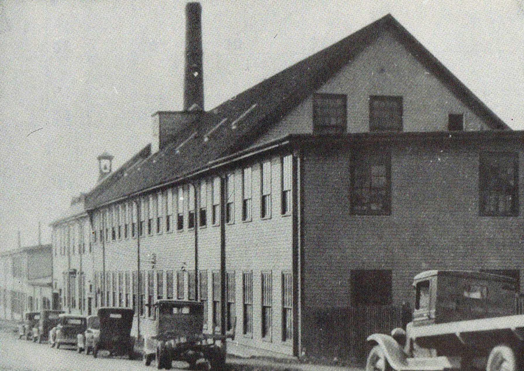
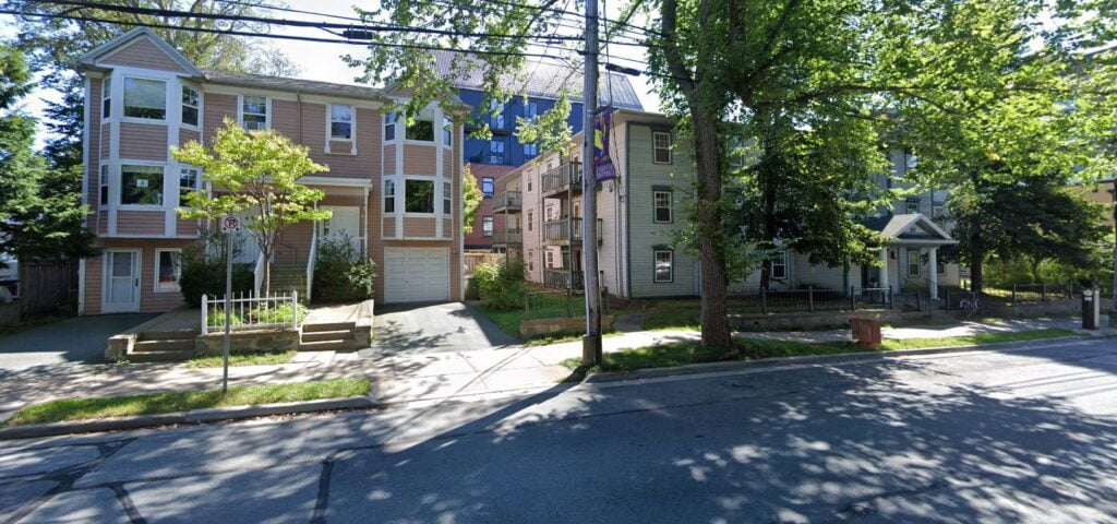
At the corner of Wentworth and Ochterloney Streets looking north east, land that has since passed into new hands and is now a residential building.
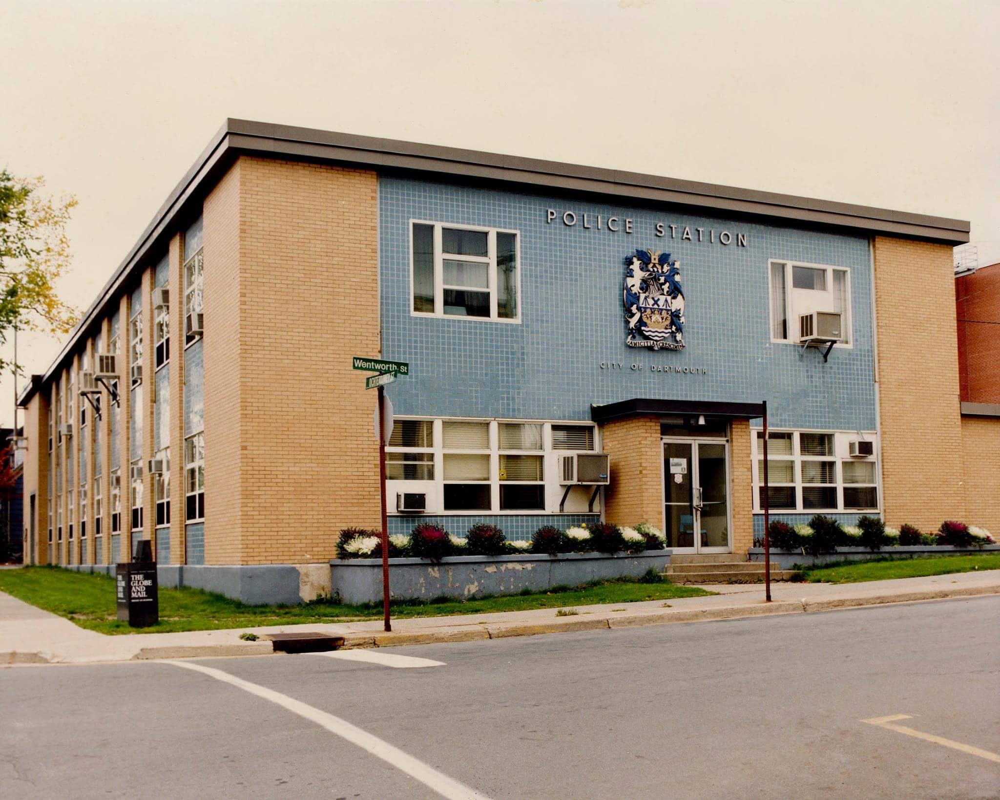
Ochterloney Street between Dundas and Wentworth looking south, Town Hall was at left, Police Station at right.
DartmouthNS000 1DartmouthNS001 1DartmouthNS002 1DartmouthNS003 1DartmouthNS004“DARTMOUTH POLICE SERVICE (NS) Amalgamated with Halifax Regional Police Department in 1996″ https://policecanada.ca/policeca/ns/darmouth/index.html
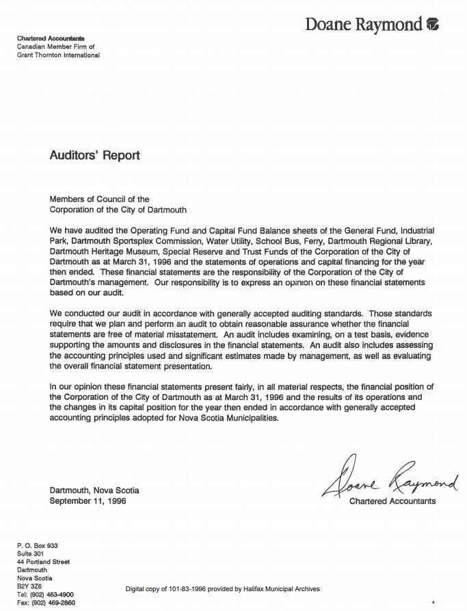
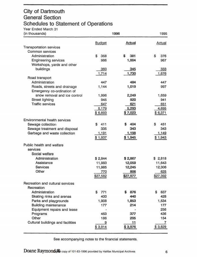
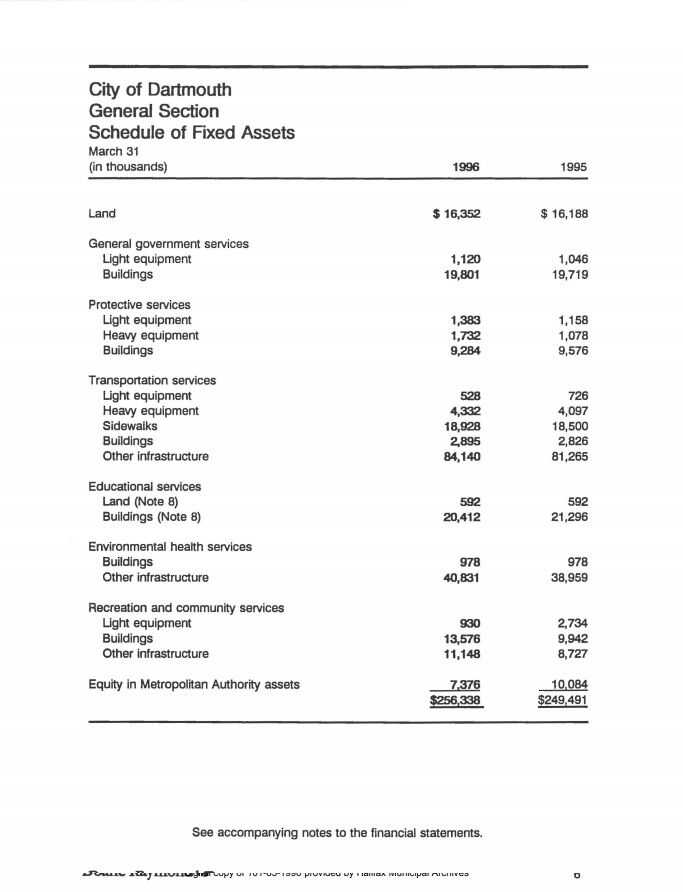
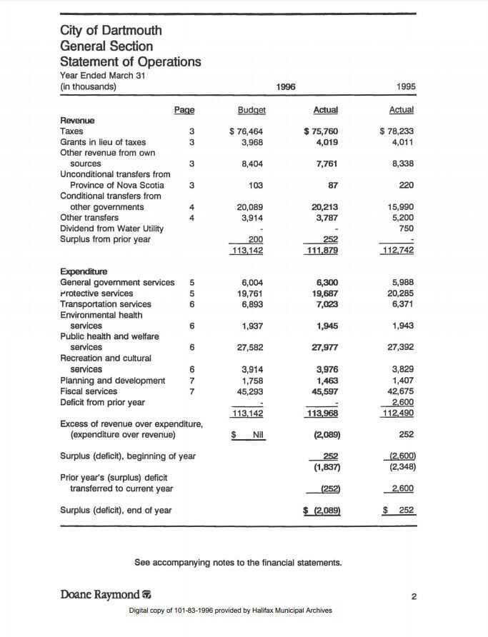
“In our opinion these financial statements present fairly, in all material respects, the financial position of the Corporation of the City of Dartmouth as at March 31, 1996 and the results of its operations and the changes in its capital position for the year then ended in accordance with generally accepted accounting principles adopted for Nova Scotia Municipalities.”
The final financial statement of the City of Dartmouth is a great starting point with which to understand Nova Scotia’s “amalgamation” in the parlance of our crown adjacent ruling class. It also presents a great refresher for those who might have forgotten where we were before.
Dartmouth School Board, Dartmouth Housing Board, Dartmouth Library, Dartmouth Common and Dartmouth Ferry. Dartmouth’s quarter billion dollars in infrastructure, stolen without even a non-binding plebiscite and then absorbed into the borg. We had some iota of local control of what were municipal – Healthcare, Education, Policing, Transport, Social Housing; all with long constitutional predicate, since lost to this ever more centralized twice municipalized “government”. “Social services”, especially, exposed to decades of disinvestment seemingly by design without any corresponding increase in a healthcare market with options.
The fruits of these deinstitutionalizing labors have come in the form of a perpetual crisis in education and healthcare. Our (supposedly) “public” (but certainly a monopoly) government social services in ruins now heaped upon the vassals, who are blamed for the rot that’s taken over all of these institutions — when any control they could hope to have had over them ended in 1996 with “amalgamation”.