
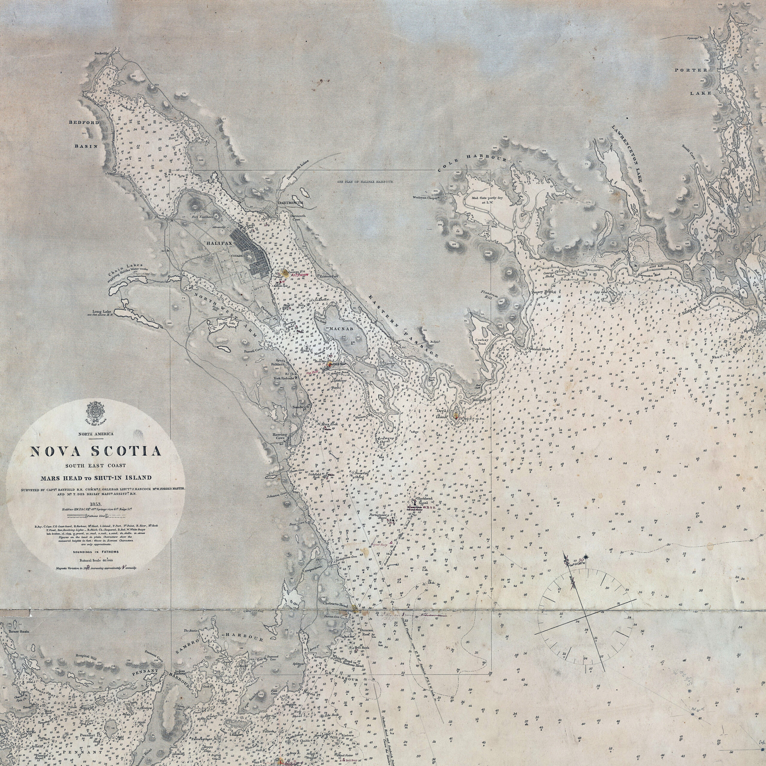
“North America. Nova Scotia: South East Coast. Mars Head to Shut In Island / Surveyed by Captn. Bayfield R.N., Commr. J. Orlebar, Lieut. J. Hancock, , Mr. W. Forbes Master. and Mr. T Des Brisay Mastr. Assist. R.N. 1853”. 1865 [London]. https://collections.library.yale.edu/catalog/15535461
Related posts:
- The north eastern coast of North America : from New York to Cape Canso, including Sable Island Lionel Pincus and Princess Firyal Map Division, The New York Public Library. “The north eastern coast of North America : from New York to Cape Canso, including Sable Island” The New York Public Library Digital Collections. 1848. https://digitalcollections.nypl.org/items/510d47da-f0b2-a3d9-e040-e00a18064a99...
- A summary of colonial law “The colonies now belonging to the Crown of Great Britain, exclusive of those under the government of the East India Company, (to which this work does not profess to extend,) are as follows: In the West Indies and South America:...
- Southeast Coast of Nova Scotia Des Barres, Joseph F. W. The sea coast of Nova Scotia; exhibiting the diversities of the coast, and the face of the country near it: the banks, rocks, shoals, soundings, &c. Together with remarks and directions for the conveniency of...
- A brief description of Nova Scotia with plates of the principal harbors “Since 1749 Nova Scotia has been governed by: “A Mr. Stokes was employed by the merchants of Milford in England, to persuade the Nantucket settlers to remove (to Milford in England): the offers were too liberal to be rejected, and...
- S.e. coast of Nova Scotia: from the most recent British surveys “S.e. coast of Nova Scotia : from the most recent British surveys” 1889. https://collections.leventhalmap.org/search/commonwealth:jh343x78f...
- “A correct map of the coast of New England” “New Scotland”, “Annapolis Royal”. “A large fold-out chart of the New England coast appeared from 1732 to 1760 in “The English Pilot, The Fourth Book”, the standard 18th-century British navigational guide to American waters … Reduced from a chart published...
- “The general cession of Nova Scotia” 220. Mr. Delafaye to the Council of Trade and Plantations. I have laid before the Lords Justices your representation of the proper measures to be taken for the security of Carolina and Nova Scotia. Their Excys. judging that care should...
- “Articles proposed by Capt. Breedon on the part of Col. Thos. Temple, Lieut. Gen. of Nova Scotia, to Lord Fienes and others, the Company of Adventures; Petition of Capt. Thomas Breedon, merchant, of New England, to Richard Cromwell, Lord Protector” 64. Minute of Articles proposed by Capt. Breedon on the part of Col. Thos. Temple, Lieut. Gen. of Nova Scotia, to Lord Fienes and others, the Company of Adventures, for settling a trade in those parts; the course first designed...
- Halifax (and Dartmouth) (Nova Scotia), from McNab’s Island S.W. Chandler & Bro. “Halifax (Nova Scotia), from McNab’s Island” 1855. Lithograph with light bluish grey tint-stone and water colour on wove paper. Laid down on cardboard. https://www.torontopubliclibrary.ca/detail.jsp?Entt=RDMDC-JRR57&R=DC-JRR57...
- History of Nova Scotia, Cape Breton, the Sable Islands, New Brunswick, Prince Edward Island, the Bermudas, Newfoundland, &c., &c. “The territorial distribution of the Nova Scotia government is – 1. Eastern division, 2. Middle; 3. Western; 4. Halifax; 5. Cape Breton; there are ten counties, some of which are again subdivided into districts and townships for the more convenient...