
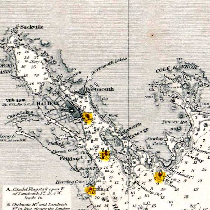
“S.e. coast of Nova Scotia : from the most recent British surveys” 1889. https://collections.leventhalmap.org/search/commonwealth:jh343x78f
Related posts:
- “A correct map of the coast of New England” “New Scotland”, “Annapolis Royal”. “A large fold-out chart of the New England coast appeared from 1732 to 1760 in “The English Pilot, The Fourth Book”, the standard 18th-century British navigational guide to American waters … Reduced from a chart published...
- A Chart Of The Sea Coasts Of The Peninsula Of Nova Scotia Morris, Charles. “A CHART OF THE SEA COASTS OF THE PENINSULA OF NOVA SCOTIA” 1755. https://collections.leventhalmap.org/search/commonwealth:hx11z491q...
- A Map Of The Surveyed Parts Of Nova Scotia, 1756 Brewse, John. “A Map of the Surveyed Parts of Nova Scotia MDCCLVI”, 1756. https://collections.leventhalmap.org/search/commonwealth:hx11z499x...
- A Plan Of Halifax Harbour In Nova Scotia 1760 Davenport R.A. “A PLAN OF HALIFAX HARBOUR IN NOVA SCOTIA 1760” https://collections.leventhalmap.org/search/commonwealth:hx11z018w...
- “A chart of the coast of America from New found Land to Cape Cod” “Sesembre” or Sambro, which is at the mouth of Halifax Harbor. I’m not sure if “Baye Senne” then is meant to represent it or another subsequent indentation in a coast that is nothing but indentations and harbors, but it does...
- “A new map of Nova Scotia, and Cape Britain: With the adjacent parts of New England and Canada” “Bay of Fundy or Argal”, “Gulf of Nova Scotia”, “Cape Britain” “A new map of Nova Scotia, and Cape Britain: With the adjacent parts of New England and Canada, composed from a great number of actual surveys” Jefferys, Thomas. [London]...
- “as much a part of Nova Scotia, as Cornhill is of England” “The French King has found a way to seperate the following places from Nova Scotia, pretending they do not belong to it, tho they are as much a part of Nova Scotia, as Cornhill is of England. Cleues que, K....
- Southeast Coast of Nova Scotia Des Barres, Joseph F. W. The sea coast of Nova Scotia; exhibiting the diversities of the coast, and the face of the country near it: the banks, rocks, shoals, soundings, &c. Together with remarks and directions for the conveniency of...
- Metropolitan map and street guide Halifax and Dartmouth, Nova Scotia Here you can see the beltway as political actor, meant to separate what was once the Town of Dartmouth from the communities it had just annexed, Westphal, Woodlawn and Woodside, to become the City of Dartmouth. Tacoma Drive, Penhorn Drive...
- Dartmouth town, 1864 From: Topographical township map of Halifax County, Nova Scotia / from actual surveys made, drawn, & engraved by and under the direction of H.F. Walling. Map of Nova Scotia and adjacent provinces, Creator: Walling, Henry Francis, 1825-1888, Publication Date: 1864,...