
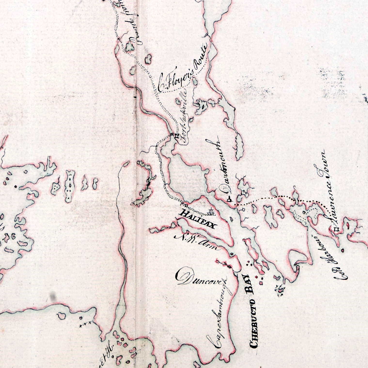
Brewse, John. “A Map of the Surveyed Parts of Nova Scotia MDCCLVI”, 1756. https://collections.leventhalmap.org/search/commonwealth:hx11z499x
Related posts:
- A Chart Of The Sea Coasts Of The Peninsula Of Nova Scotia Morris, Charles. “A CHART OF THE SEA COASTS OF THE PENINSULA OF NOVA SCOTIA” 1755. https://collections.leventhalmap.org/search/commonwealth:hx11z491q...
- A Plan Of Halifax Harbour In Nova Scotia 1760 Davenport R.A. “A PLAN OF HALIFAX HARBOUR IN NOVA SCOTIA 1760” https://collections.leventhalmap.org/search/commonwealth:hx11z018w...
- S.e. coast of Nova Scotia: from the most recent British surveys “S.e. coast of Nova Scotia : from the most recent British surveys” 1889. https://collections.leventhalmap.org/search/commonwealth:jh343x78f...
- “A correct map of the coast of New England” “New Scotland”, “Annapolis Royal”. “A large fold-out chart of the New England coast appeared from 1732 to 1760 in “The English Pilot, The Fourth Book”, the standard 18th-century British navigational guide to American waters … Reduced from a chart published...
- “A chart of the coast of America from New found Land to Cape Cod” “Sesembre” or Sambro, which is at the mouth of Halifax Harbor. I’m not sure if “Baye Senne” then is meant to represent it or another subsequent indentation in a coast that is nothing but indentations and harbors, but it does...
- “A Map of the surveyed parts of Nova Scotia” “A Map of the surueyed parts of Noua Scotia”, [175-?]. https://collections.library.yale.edu/catalog/15826739...
- “A new map of Nova Scotia, and Cape Britain: With the adjacent parts of New England and Canada” “Bay of Fundy or Argal”, “Gulf of Nova Scotia”, “Cape Britain” “A new map of Nova Scotia, and Cape Britain: With the adjacent parts of New England and Canada, composed from a great number of actual surveys” Jefferys, Thomas. [London]...
- A map of Cabotia: comprehending the provinces of Upper and Lower Canada, New-Brunswick and Nova-Scotia with Breton Island, Newfoundland & c. and including also the adjacent parts of the United States Lionel Pincus and Princess Firyal Map Division, The New York Public Library. “A map of Cabotia” The New York Public Library Digital Collections. 1814. https://digitalcollections.nypl.org/items/a9d6bc40-2357-0133-af56-58d385a7b928...
- This Map of the Province of Nova-Scotia and parts adjacent Noticed: “America Point” at the north end of the Halifax peninsula, “Warren’s Point” and “Saw Mill River” on the Dartmouth side. Turner, James. “This Map of the Province of Nova-Scotia and parts adjacent” Sold by Andrew Hook in Philadelphia 2d....
- “as much a part of Nova Scotia, as Cornhill is of England” “The French King has found a way to seperate the following places from Nova Scotia, pretending they do not belong to it, tho they are as much a part of Nova Scotia, as Cornhill is of England. Cleues que, K....