
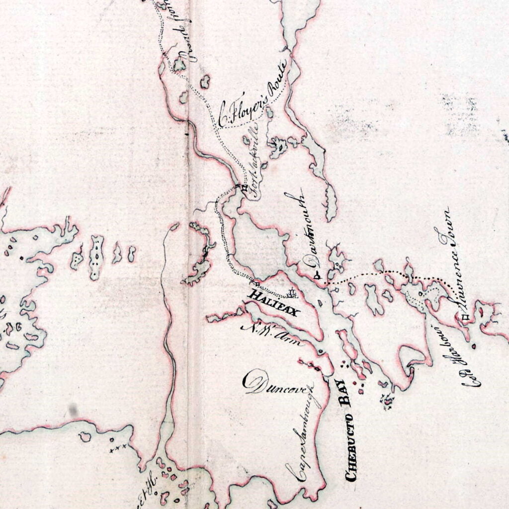


“A Map of the surueyed parts of Noua Scotia”, [175-?]. https://collections.library.yale.edu/catalog/15826739
Related posts:
- “A new map of Nova Scotia, and Cape Britain: With the adjacent parts of New England and Canada” “Bay of Fundy or Argal”, “Gulf of Nova Scotia”, “Cape Britain” “A new map of Nova Scotia, and Cape Britain: With the adjacent parts of New England and Canada, composed from a great number of actual surveys” Jefferys, Thomas. [London]...
- A chart of the peninsula of Nova Scotia “A chart of the peninsula of Nova Scotia by Charles Morris.” Morris, Charles. 1758. https://collections.library.yale.edu/catalog/15826747...
- A Chart of ye North part of America “A Chart of ye North part of America, For Hudson’s Bay Comonly called ye North West Passage. By Iohn Thornton Hidrographer at the Platt in the Minories”, London, 1677-1682. https://exhibits.stanford.edu/ruderman/catalog/rt796sf3559, https://collections.library.yale.edu/catalog/2047241...
- A plan of the harbour of Halifax A somewhat detailed representation of Dartmouth by Charles Morris showing what appears to be four blockhouses and what is perhaps the connecting palisade. Mills are also noted along with a windmill just beyond the mill stream, near what would be...
- “A correct map of the coast of New England” “New Scotland”, “Annapolis Royal”. “A large fold-out chart of the New England coast appeared from 1732 to 1760 in “The English Pilot, The Fourth Book”, the standard 18th-century British navigational guide to American waters … Reduced from a chart published...
- A Map Of The Surveyed Parts Of Nova Scotia, 1756 Brewse, John. “A Map of the Surveyed Parts of Nova Scotia MDCCLVI”, 1756. https://collections.leventhalmap.org/search/commonwealth:hx11z499x...
- Nova Scotia: South East Coast. Mars Head to Shut In Island “North America. Nova Scotia: South East Coast. Mars Head to Shut In Island / Surveyed by Captn. Bayfield R.N., Commr. J. Orlebar, Lieut. J. Hancock, , Mr. W. Forbes Master. and Mr. T Des Brisay Mastr. Assist. R.N. 1853”. 1865...
- Carta d’una parte dell’ America Settentrionale “Carta d’una parte dell’ America Settentrionale : che serve per ben poter intendere le pretensioni delli Inglesi, esposte ne loro memoriali in occasione della regolazione de limiti con la Francia nell’ America svdetta.” [1755?] [Verona?] https://collections.library.yale.edu/catalog/15823925...
- “A map of New Scotland with its dependencies and a succint account of the country” “The Province of New Scotland in Latin Nova Scotia is properly that large Peninsula known formerly by the name of Acady; tho’ in the Charter granted by K. Charles 1st all the seacoast from New England up to the straits...
- A map of Cabotia: comprehending the provinces of Upper and Lower Canada, New-Brunswick and Nova-Scotia with Breton Island, Newfoundland & c. and including also the adjacent parts of the United States Lionel Pincus and Princess Firyal Map Division, The New York Public Library. “A map of Cabotia” The New York Public Library Digital Collections. 1814. https://digitalcollections.nypl.org/items/a9d6bc40-2357-0133-af56-58d385a7b928...