

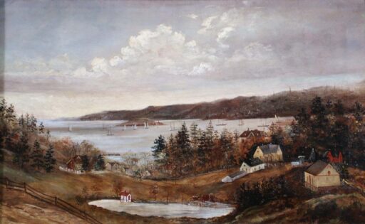
This is a view of Dartmouth Cove, George’s Island and Halifax which looks to be from somewhere on the hilly 200 block of Portland Street behind Linden Lea and St. George’s Lane, whose pond is seen in the foreground. Hazlehurst can be seen at middle right in the trees.
Patton, Mrs. J.P. “View of Halifax from Dartmouth” 1881. https://archives.novascotia.ca/ports/archives/?ID=19
Related posts:
- View of Halifax (from Dartmouth), 1757 “View of Halifax”, July 1757. https://archives.novascotia.ca/maps/archives/?ID=93...
- View of (Dartmouth, from) His Majesty’s Dockyard, Halifax “View of His Majesty’s Dockyard, Halifax”, 1760. https://archives.novascotia.ca/maps/archives/?ID=107&Page=201320535...
- Sullivan’s Pond (from the banks of Findlay’s Pond), Dartmouth This photo appears to be looking north, the opposite direction of this other photo of Sullivan’s Pond and Findlay’s Pond, but more than 20 years later on Oct 24th, 1890. The large three story house in the center of the...
- Circular dam foot of Sullivan’s Pond, route of Shubenacadie Canal near Dartmouth “Lakeside”, later ‘‘Beechmount Apartments” and now 84 Crichton Avenue, seen directly ahead behind the circular dam, which, especially in reference to this photo from Findlay’s Pond, helps triangulate the location of this photo to somewhere near the bottom of Maple Street....
- Sullivan’s Pond, 1899 The Octagon house seen at left. You’re not likely to find a cow grazing along the shores of Sullivan’s Pond these days! “Sullivan’s Pond”, 1899. https://archives.novascotia.ca/photocollection/archives/?ID=5336 (Date erroneously listed as 1955, likely mixed up with another view of Sullivan’s Pond...
- Sullivan’s Pond, 1955 The Octagon house seen at middle right. “Sullivan’s Pond”, 1955. https://archives.novascotia.ca/photocollection/archives/?ID=5337...
- Dartmouth, Aerial View St. Peter’s Church seen at upper middle, First Baptist at Victoria at middle right. Christ Church at middle, Victoria Road Baptist church is seen a block behind between it and its hall, Grace United Church is seen at middle bottom,...
- “Survey of Ferry-House Lot belonging to J.P. Mott Esq.” This map encompasses the bottom of Old Ferry Road once known as “Green Lane”, near Newcastle Street and Hazelhurst Street today. The (once massive) willow trees seen here are noted elsewhere. See Also: “Survey of Ferry-House Lot belonging to J.P....
- The Brave Fireman of Dartmouth “The Brave Fireman of Dartmouth, who always came to Halifax to help the Union Engine Co. Good many of the old timers have passed away. Dartmouth Engine Co.” “The Brave Fireman of Dartmouth”, 1886. https://archives.novascotia.ca/connors/archives/?ID=621, Better copy: https://archives.novascotia.ca/connors/archives/?ID=616...
- Aerial view of part of Dartmouth, 1931 “Aerial View: Halifax Harbour Narrows showing Dartmouth”, 1931. https://archives.novascotia.ca/photocollection/archives/?ID=5573...