History of Halifax City

“The [Mi’kmaq] had appeared in the neighborhood of the town for several weeks, but intelligence had been received that they had commenced hostilities, by the capture of twenty persons at Canso… On the last day of September they made an attack on the sawmill at Dartmouth, then under the charge of Major Gilman. Six of his men had been sent out to cut wood without arms. The [Mi’kmaq] laid in ambush, killed four and carried off one, and the other escaped and gave the alarm, and a detachment of rangers was sent after the [Mi’kmaq], who having overtaken them, cut off the heads of two [Mi’kmaq] and scalped one.

This affair is mentioned in a letter from a gentleman in Halifax to Boston, dated October 2nd as follows: “About seven o’clock on Saturday morning before, as several of Major Gilman’s workmen with one soldier, unarmed, were hewing sticks of timber about 200 yards from his house and mills on the east side of the harbor, they were surprised by about 40 [Mi’kmaq], who first fired two shots and then a volley upon them which killed four, two of whom they scalped, and cut off the heads of the others, the fifth is missing and is supposed to have been carried off.”

“The Governor deeming it expedient that some permanent system of judicial proceedings to answer the immediate exigencies of the Colony should be established, a committee of Council was accordingly appointed to examine the various systems in force in the old Colonies. On 13th December, Mr. Green reported that after a careful investigation, the laws of Virginia were found to be most applicable to the present situation of the province. The report was adopted. It referred principally to the judicial proceedings in the General Courts, the County Courts, and other tribunals.”

[More on the constitutional connections between Nova Scotia and Virginia: Virginia and Nova Scotia: An Historical Note, “As Near as May Be Agreeable to the Laws of this Kingdom”: Legal Birthright and Legal Baggage at Chebucto, 1749, Draught of H.M. Commission to Richard Philips to be Governor of Placentia and Cap. General and Governor in Chief of Nova Scotia or Accadie, June 19 1719 (relying on) Commission and Instructions to the Earl of Orkney for the Government of Virginia, 1715, Catalogue of books in the Nova Scotia Legislative Council Library, The First Charter of Virginia (1606)]

“In the month of August, 1750, three hundred and fifty-three settlers arrived in the ship Alderney… Those who came in the ship Alderney, were sent to the opposite side of the harbor, and commenced the town of Dartmouth, which was laid out in the autumn of that year. In December following, the first ferry was established, and John Connor appointed ferryman by order in Council.

In the Spring of the following year the [Mi’kmaq] surprised Dartmouth at night, scalped a number of settlers and carried oft several prisoners. The inhabitants, fearing an attack, had cut down the spruce trees around their settlement, which, instead of a protection, as was intended, served as a cover for the enemy. Captain Clapham and his company of Rangers were stationed on Block-house hill, and it is said remained within his block-house firing from the loop-holes, during the whole affair. The [Mi’kmaq] were said to have destroyed several dwellings, sparing neither women nor children. The light of the torches and the discharge of musketry alarmed the inhabitants of Halifax, some of whom put off to their assistance, but did not arrive in any force till after the [Mi’kmaq] had retired. The night was calm, and the cries of the settlers, and whoop of the [Mi’kmaq] were distinctly heard on the western side of the harbor. On the following morning, several bodies were brought over — the [Mi’kmaq] having carried off the scalps. Mr. Pyke, father of the late John George Pyke, Esq., many years police magistrate of Halifax, lost his life on this occasion. Those who fled to the woods were all taken prisoners but one. A court martial was called on the 14th May, to inquire into the conduct of the different commanding officers, both commissioned and non-commissioned, in permitting the village to be plundered when there were about 60 men posted there for its protection.

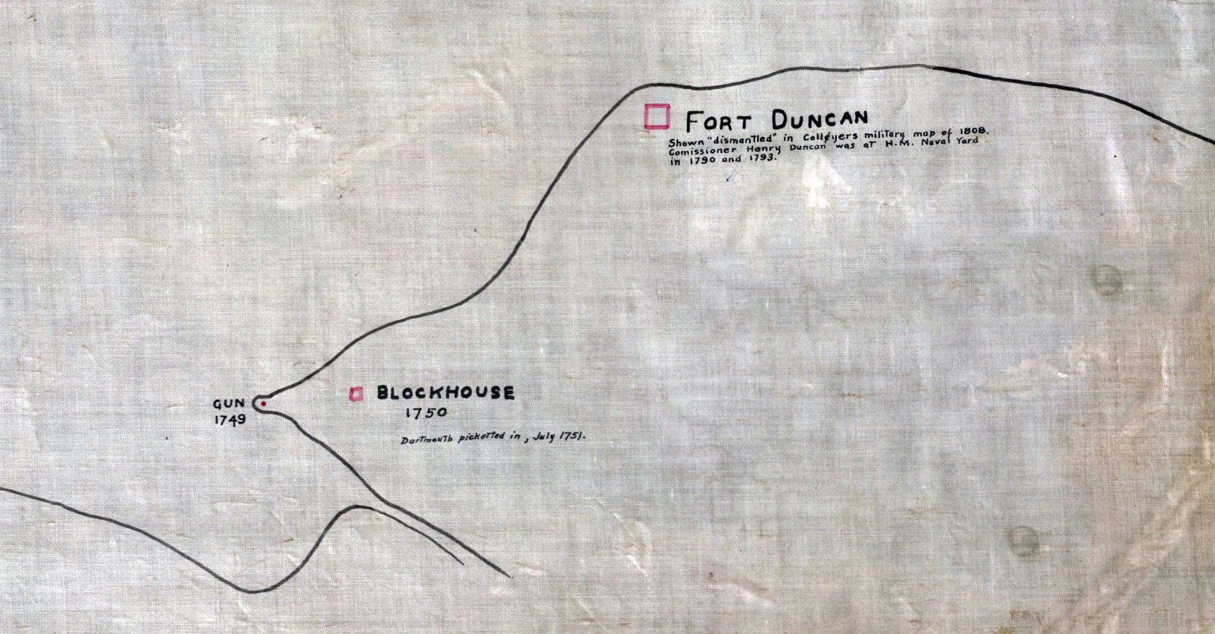
There was a guard house and small military post at Dartmouth from the first settlement, and a gun mounted on the point near the Saw Mill (in the cove) in 1749. One or two transports, which had been housed over during winter and store ships were anchored in the cove, under cover of this gun, and the ice kept broke around them to prevent the approach of the [Mi’kmaq]. The attempt to plant a settlement at Dartmouth, does not appear to have been at first very successful. Governor Hobson in his letter to the Board of Trade, dated 1st October, 1753, says, “At Dartmouth there is a small town well picketed in, and a detachment of troops to protect it, but there are not above five families residing in it, as there is no trade or fishing to maintain any inhabitants, and they apprehend danger from the [Mi’kmaq] in cultivating any land on the outer side of the pickets.”

There is no record of any concerted attack having been made by the [Mi’kmaq] or French on the town of Halifax.”

“German palatine settlers (arrived on the 10th of June 1751, and) they were employed at Dartmouth in picketing in the back of the town.”

“On February 3rd 1752, a public ferry was established between Halifax and Dartmouth and John Connors appointed ferryman for three years, with the exclusive privilege, and ferry regulations were also established.”

“The government mills at Dartmouth, under charge of Captain Clapham, were sold at auction in June. They were purchased by Major Gilman for $310.”

“In 1754, an order was made for permission to John Connors, to assign the Dartmouth Ferry to Henry Wynne and William Manthorne.”

January 26th 1756, the term of Henry Wynne and William Manthorne’s licenses of the Dartmouth and Halifax ferry having expired, John Rock petitioned and obtained the same on the terms of his predecessors.”

“(1757) was also memorable as the one in which Representative government was established in Nova Scotia. The subject of calling a Legislative Assembly had undergone much discussion. It had been represented by the Governor and Council, to the authorities in England, that such a step at that particular time would be fraught with much danger to the peace of the colony. Chief Justice Belcher, however, having given his opinion that the Governor and Council possessed no authority to levy taxes, and their opinion being confirmed in England, it was resolved by council on January 3rd 1757, that a representative system should be established and that twelve members should be elected by the province at large, until it could be conveniently divided into counties, and that the township of Halifax should send four members, Lunenburg two, Dartmouth one, Lawrencetown one, Annapolis Royal one, and Cumberland one, making in all twenty-two members, and the necessary regulations were also made for carrying into effect the object intended.”

“In September, 1785, a number of whalers from Nantucket came to Halifax ; three brigantines and one schooner, with crews and everything necessary for prosecuting the whale fishery, which they proposed to do under the British flag. Their families were to follow. A short time after they were joined by three brigantines and a sloop from the same place. On the twentieth of October following, the Chief Land Surveyor was directed to make return of such lands as were vacant at Dartmouth to be granted to Samuel Starbuck, Timothy Folger, and others, from Nantucket, to make settlement for the whalers. The Town of Dartmouth had been many years previously laid out in lots which had been granted or appropriated to individuals, some of whom had built houses, and others though then vacant, had been held and sold from time to time by their respective owners. Most of these lots were reported vacant by Mr. Morris, the surveyor, and seized upon by the Government, as it is said, without any proceeding of escheat, and re-granted to the Quakers from Nantucket, which caused much discontent, and questions of title arose and remained open for many years after.”

“The whale fishery was the chief subject which engaged the attention of the public during (1785). Much advantage was expected to accrue to the commerce of the place from the Quakers from Nantucket having undertaken to settle in Dartmouth. They went on prosperously for a short time, until they found the commercial regulations established in England for the Colonies were hostile to their interests, and they eventually removed, some of them, it is said, to Wales and other parts of Great Britain, where they carried on their fishery to more advantage.

A petition was presented this autumn to the Governor and Council from a number of merchants, tradesmen and other inhabitants, praying for a Charter of Incorporation for the Town of Halifax. This was the first occasion on which the subject was brought prominently before the public. It was, however, not deemed by the government ” expedient or necessary ” to comply with the prayer of the petition. The reasons are not given in the Minute of Council, which bears date 17th November, 1785. The names of the Councillors present were Richard Bulkeley, Henry Newton, Jonathan Binney, Arthur Goold, Alexander Brymer, Thomas Cochran and Charles Morris.

The functions of His Majesty’s Council at this period of our history embraced all departments of executive authority in the Colony. They were equally supreme in the control of town affairs as those of the province at large. The magistrates, though nominally the executive of the town, never acted in any matter of moment without consulting the Governor and Council. The existence of a corporate body having the sole control of town affairs would in a great measure deprive them of that supervision which they no doubt deemed, for the interest of the community, should remain in the Governor and Council.”

“Folger and Starbuck, the Quaker whalers, who settled at Dartmouth a year or two since, left (in 1792), for Milford Haven in Great Britain, where they expected to carry on their whale fishery with greater facilities than at Dartmouth.”

“…the Governor, M. Danseville, with several hundred prisoners and stores were brought to Halifax. They landed on the 20th of June (1793). Governor Danseville was placed on parole, and resided at Dartmouth for many years in the house known as Brook House, now or lately the residence of the Hon. Michael Tobin, Jr., about a couple of miles or more from Dartmouth town. The old gentleman displayed some taste in beautifying the grounds at Brook House. He built a fish pond and laid out walks among the beech and white birch groves near the house. The pond still remains, but the walks and most of the trees have long since disappeared. He remained a prisoner with an allowance from Government until the peace of 1814, when he returned to his own country a zealous royalist.”

“a poll tax had been imposed by Act of Legislature in 1791.”

“During the spring of 1796 Halifax suffered from a scarcity of provisions. The inhabitants were indebted to Messrs. Hartshorne and Tremain, whose mills at Dartmouth enabled them, through the summer, to obtain flour at a reduced price and to afford a sufficient supply for the fishery.”

“The following list of town officers appointed by the Grand Jury for the Town March 5th 1806, will be found interesting: … Edward Foster, Surveyor of highways from Dartmouth Town Plot to the Basin; Samuel Hamilton, Constable from Dartmouth Town Plot to the Basin; Jon. Tremain, Sr., William Penny, Surveyors of Highways, Dartmouth Town Plot; David Larnard, Constable, Dartmouth Town Plot; James Munn, Pound Keeper, Dartmouth Town Plot; Henry Wisdom, Surveyor of Highways from the Ferry up the Preston Road to Tanyard”

“In the autumn (of 1814) the small pox made its appearance in Dartmouth and Preston and was very fatal among the Chesapeake blacks].”

“There were two ferries (in 1815). The upper ferry was conducted by John Skerry, whose memory is still cherished by many, both in Dartmouth and Halifax, as one of the most obliging and civil men of his day. Skerry’s wharf in Dartmouth was a short distance south of the steam boat wharf (—at the foot of Ochterloney Street today). The other ferry was the property of Mr. James Creighton, known as the Lower Ferry, situate to the south of Mott’s Factory (—at the bottom of Old Ferry Road). It was conducted for Mr. Creighton by deputy and was afterwards held under lease by Joseph Findlay, the last man who ran a ferry boat with sails and oars in Halifax Harbor. These ferry boats were furnished with a lug sail and two and sometimes four oars. They were large clumsy boats and occupied some thirty or forty minutes in making the passage across the harbor. There were no regular trips at appointed hours. When the boat arrived at either side the ferryman blew his horn (a conch shell) and would not start again until he had a full freight of passengers. The sound of the conch and the cry of ”Over! Over! ” was the signal to go on board. The boats for both ferries landed at the Market Slip at Halifax.

An act of the Legislature had been obtained this session to incorporate a Steamboat Company with an exclusive privilege of the ferry between Halifax and Dartmouth for 25 years. They could not succeed in getting up a company, steam navigation being then in its infancy, and in the following year had the act amended to permit them to run a boat by horses to be called the Team-boat. This boat consisted of two boats or hulls united by a platform with a paddle between the boats. The deck was surmounted by a round house which contained a large cogwheel, arranged horizontally inside the round house, to which were attached 8 or 9 horses harnessed to iron stanchions coming down from the wheel. As the horses moved round, the wheel turned a crank which moved the paddle. It required about twenty minutes for this boat to reach Dartmouth from Halifax. It was considered an immense improvement on the old ferry boat arrangement, and the additional accommodation for cattle, carriages and horses was a great boon to the country people as well as to the citizens of Halifax, who heretofore had been compelled to employ Skerry’s scow when it was found necessary to carry cattle or carriages from one side of the harbor to the other.

The first trip of the Team-boat was made on the 8th November, 1810. The following year an outrage was committed which caused much excitement and feeling in the town. All the eight horses in the boat were stabbed by a young man named Hurst. No motive for this cruel act could be assigned, drunkenness alone appearing to be the cause. The culprit was tried for the offence and suffered a lengthy imprisonment. Mr. Skerry kept up a contest with the Company for several years, until all differences were arranged by his becoming united with the Company, and after a short time old age and a small fortune, accumulated by honest industry, removed him from the scene of his labors.

The team-boat after a year or two received an addition to her speed by the erection of a mast in the centre of the round house, on which was hoisted a square sail when the wind was fair, and afterwards a topsail above, which gave her a most picturesque appearance on the water. This addition considerably facilitated her motion and relieved the horses from their hard labor. As traffic increased several small paddle boats were added by the Company, which received the appellation of Grinders. They had paddles at the sides like a steamboat, which were moved by a crank turned by two men. In 1818 the proprietors of the old ferries petitioned the House of Assembly against the Teamboat Company suing these small boats as contrary to the privilege given them by the Act of Incorporation. It afterwards became a subject of litigation until the question was put an end to by Mr. Skerry becoming connected with the Company. Jos. Findlay continued to run his old boats from the south or lower ferry until about the year 1835.”

“During the month of February (1818), the harbor was blocked up with float ice as far down as George’s Island. Between 13th and 20th, persons crossed from Dartmouth on the ice at the Narrows.”

“By the 27th of January 1821 the ice formed a firm bridge between Halifax and Dartmouth, over which a continuous line of sleighs, teams and foot passengers might be seen on market days.”

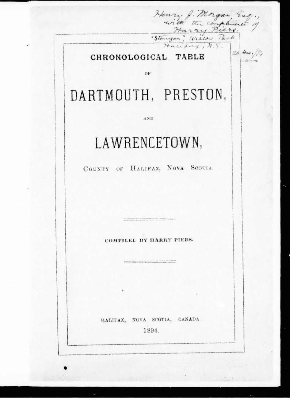
Akins, Thomas B., 1809-1891. History of Halifax City. [Halifax, N.S.?: s.n.], 1895. https://hdl.handle.net/2027/aeu.ark:/13960/t7zk65s8s

Fortifications (in Dartmouth)

Fort Duncan: Shown “dismantled” in Collyers military map of 1808. Commissioner Henry Duncan was at H.M Naval Yard in 1790 and 1793.

Blockhouse: 1750. Dartmouth picketed in, July 1751.

Gun: 1749.

Eastern Battery, Fort Clarence: 1754. Freestone tower there in Jan 1810 & in 1834. Tower removed about 1865, when new works were begun. Fort Clarence reconstructed 1865 to 1868 (Mil. recds). Site sold to Imperial Oil Co, 1927. Known as Eastern Battery in 1786.

“Halifax Fortifications”, 1928. https://archives.novascotia.ca/maps/archives/?ID=1443

Footprints Around and About Bedford Basin

“East side of Bedford Basin: The winding shore above the narrows has many picturesque points and coves to recommend it to the lover of natural scenery. It has also historical associations, but not, perhaps, of such prominence as that of the western side. High hills, clad with pine and spruce, rise conspicuously above the sparkling waters, affording wide views of the city and harbor of Halifax.

Tuft’s Cove, which was named after Gerisham Tufts, who belonged to a family extensively known in the United States, was the first to obtain a grant of the land surrounding this cove. The impression prevailed that he belonged to New England and came to Halifax early in the settlement of the town. The land above the Tufts property was granted to Ezekiel Gilman. He was one of the two army majors, retired, that accompanied the first settlers to Halifax. Leonard Lochman, after whom Lockman street is named was the other. In Murdoch’s history of Nova Scotia the following tragedy, with which Gilman was connected, is thus related:

On Saturday, 10th Oct., 1749 (N.S.) the [Mi’kmaq] committed acts of hostility at a saw mill that had been erected in Chebucto bay. Six men without arms were sent out by Major Gilman to cut wood for the mill. Of these six, four were killed and one made prisoner by a party of [Mi’kmaq], who had lain in ambush. The sixth man made good his escape from them. The saw mill was near Dartmouth Cove. On the following day, Sunday, the governor and council met on board the Beaufort. They decided not to declare war against the [Mi’kmaq] as that would be in some sort to own them as a “free people” – that they ought to be looked upon as rebels to H.M. government, or as bandatti ruffians. War, however, was to be made on them; a reward offered for prisoners and for scalps; Major Gilman to raise another independent company of volunteers to scour all the country round the bay; a proclamation issued reciting the [indigenous] hostilities recently committed at Canso and Chebucto, and ordering all officers, civil and military, and all H.M. subjects to take and destroy the [Mi’kmaq], and offering ten guineas for each [indigenous person] living or dead, or his scalp, as was the custom of America. Major Gilman was now instructed to raise his company and get them hatchets, haversacks and snowshoes. Gilman went to Piscataqua to enlist his company of 100 men, engaging to return with them before December.

The Gilman lands were escheated, and re-granted in trust to Admiral Sir Isaac Coffin. Coffin was a son of an officer of the customs at Boston. He was born in that town on 16th May, 1750. He entered the Navy in 1773 under the patronage of Rear-Admiral Montague, the commander-in-chief on the North American station.”


“A steamboat on Bedford Basin for the first time: The first steam boat to make a trip on Bedford Basin – indeed, it could be said, the first ferry boat propelled by steam to appear on the harbor of old Chebucto – was the Sir Charles Ogle. She was built in the cove at Dartmouth by Mr. Lyle. It was in the closing days of 1829 that the steamer was completed – the machinery on board and in order. An attempt was made to launch her on the first day of the new year. She set off in fine style, but when about two-thirds in the water she stuck in the ways, and every exertion to complete the launch at that tide were unavailing. Her length of deck was 103 feet, width of beam 20 feet, width of deck over all 35 feet, 176 tons measurement, her engine was 30 horsepower.

It was understood that the fare would be four pence, and that the steamer would make four passages an hour. The team boat, which she displaced, frequently made but four trips a day, frequently less, and sometimes in winter would not cross at all. It was considered on all hands that an excellent exchange had been made. The steamboat had two commodious cabins. In the eyes of the inhabitants she brought Dartmouth as it were to the end of the steamboat wharf, and it was anticipated that the enterprise would have an admirable effect on the life and prosperity of the village. The hope was generally indulged in that the steamer would well repay the public-spirited gentlemen who had first given to Halifax one of the wonders of science. At full tide, near midnight, the steamer was got off, and in the words of an enthusiastic townsman, uttered at the time: “she now sits in water gracefully as a swan, an honor and an advantage to the community.” On the 12th of January teams and passengers crossed the harbor in the Sir Charles Ogle, and on the following day she circumnavigated George’s Island, to the satisfaction of numerous and most respectable passengers who had taken advantage of the trip.”

Mullane, George. “Footprints Around and About Bedford Basin : a district brimful of romantic associations: some interesting facts about its early history” [Nova Scotia] : publisher not identified, [19–] https://www.canadiana.ca/view/oocihm.78665

The story of Christ Church, Dartmouth

Christ Church as seen at 10:15am, May 31st 1932, looking north from the corner of Ochterloney and Wentworth Streets. https://archives.novascotia.ca/photocollection/archives/?ID=5300

  • When Halifax was first settled, this side of the harbor was the home and hunting ground of the [Mi’kmaq].
  • Soon after the settlement of Halifax, Major Gillman built a saw mill in Dartmouth Cove on the stream flowing from the Dartmouth lakes.
  • On September 30th 1749, [Mi’kmaq] attacked and killed four and captured one out of six unarmed men who were cutting wood near Gillman’s mill.
  • In August 1750, the Alderney, of 504 tons, arrived at Halifax with 353 immigrants, a town was laid out on the eastern side of the harbor in the autumn, given the name of Dartmouth, and granted as the home of these new settlers.
  • A guard house and military fort was established at what is still known as Blockhouse hill [—the hill on King Street, at North].
  • In 1751 [Mi’kmaq] made a night attack on Dartmouth, surprising the inhabitants, scalping a number of the settlers and carrying off others as prisoners.
  • In July 1751, some German emigrants were employed in picketing the back of the town as a protection against the [Mi’kmaq].
  • In 1752, the first ferry was established, John Connor, of Dartmouth, being given the exclusive right for three years of carrying passengers between the two towns.
  • Fort Clarence was built in 1754.
  • In 1758 the first Charles Morris, the Surveyor General, made a return to Governor Lawrence giving a list of the lots in the town of Dartmouth.
  • In 1762 the same Charles Morris wrote: “The Town of Dartmouth, situate on the opposite side of the harbour, has at present two families residing there, who subsist by cutting wood.”
  • In 1785 three brigantines and one schooner with their crews and everything necessary for the whale fishery arrived, and twenty families from Nantucket were, on the invitation of Governor Parr, settled in Dartmouth. These whalers from Nantucket were Quakers in religion. Their fishing was principally in the Gulf of St. Lawrence which then abounded with black whales.
  • In 1788 a common of 150 acres [—200 acres, in keeping with with the New England tradition of “200 acres for a common, sixty acres for a Town Site“, (1808 Toler map overlay) and certain tracts for a meeting house, cemetery, school”] was granted Thomas Cochran, Timothy Folger and Samuel Starbuck in trust for the town of Dartmouth. When these good Quakers left, Michael Wallace, Lawrence Hartshorne, Jonathon Tremaine, all subsequently members of Christ Church, were made trustees [in 1798]. Acts relating to this common were passed in 1841, 1868 and 1872, and the present Dartmouth Park Commission was appointed in 1888.
  • In 1791 the idea of building a canal between the Shubenacadie river and Dartmouth by utilizing the lakes, a plan which originated with Sir John Wentworth, was brought before the legislature. The Shubenacadie Canal company was incorporated in 1826.
  • In 1792 most of the Quakers left Dartmouth. One at least, Seth Coleman, ancestor of the Colemans of today, remained.
  • In early days Lawrence Hartshorne, Johnathon Tremain and William Wilson all Churchmen, carried on grist-mills at Dartmouth Cove. At a ball given by Governor Wentworth on December 20th, 1792, one of the ornaments on the supper table was a reproduction of Messrs. Hartshorne and Tremain’s new flour mill.
  • Many French prisoners of war were brought here off the prizes brought to the port of Halifax. Some were confined in a building near the cove, which now forms part of one of the Mott factories.
  • In 1797 “Skipper” John Skerry began running a public ferry between Halifax and Dartmouth.
  • In 1809 Dartmouth contained 19 houses, a tannery, a bakery and a grist-mill.
  • In 1814 Murdoch relates that “Sir John Wentworth induced Mr. Seth Coleman to vaccinate the poor persons in Dartmouth, and throughout the township of Preston adjoining. He treated over 400 cases with great success.
  • The team boat Sherbrooke made her first trip across the harbor on November 8th, 1816.
  • As already related the first schools in the town were established by the Church of England, the teachers getting salaries, small it is true, from the Society for the Propagation of the Gospel. Mary Munn (appointed 1821) was the first teacher of the girls at a salary of £5 a year. William Walker (appointed 1824), father of E.M. Walker, and grandfather of H.R. Walker, now superintendent of Christ Church Sunday School, at £15 year of the boys. Mr. Walker held school in a little half stone house on the site of the present Central School. The S.P.G. was specially anxious for the religion instruction of the children, and the following “Prayers for the use of the Charity Schools in America”, issued by the society were doubtless regularly used by these early teachers.
  • A fire engine company was formed in 1822, a Axe and Ladder Company in 1865, and a Union Protection Company in 1876.
  • Lyle & Chapel opened a shipyard about 1823.
  • In 1828 a steam ferry boat of 30 tons, the Sir Charles Ogle, was built at the shipyard of Alexander Lyle. In 1832 a second steamer, the Boxer, was built; and in 1844 a third, the Micmac.
  • In 1836 the ice business was commenced. William Foster erecting an ice house near the Canal Bridge on Portland Street. The ice was taken in a wheel-barrow to Mr. Foster’s shop in Bedford Row, Halifax, and sold for a penny a pound.
  • In the thirties the industries of Dartmouth included besides the grist mill, of which William Wilson was chief miller, a foundry run by James Gregg on the hill back of the railway station; the manufacture of putty and oils by William Stairs; a tannery kept by Robert Stanford; a tobacco factory; the making of silk hats or “beavers” by Robinson Bros.; a soap chandlery run by Benjamin Elliott opposite Central School, and several ship building plants.
  • It is estimated that altogether $359,951.98 was spent on this canal. The stone locks and parts of the canal are all that remain today.
  • Edward H. Lowe, a leading member of Christ Church, was for many years secretary and manager of the Dartmouth Steamboat Company. At his death he was succeeded by another good Churchman, Captain George Mackenzie, whose wife was a daughter of Rev. James Stewart.
  • The first vessel built in Dartmouth was called the “Maid of the Mill”, and was used in carrying flour from the mill then in full operation.
  • In 1843 Adam Laidlaw, well known as driver of the stage coach between Windsor and Halifax, commenced cutting and storing the ice on a large scale, making this his only business.
  • In 1845 a Mechanics Institute, the first of the kind in Nova Scotia, was formed in Dartmouth.
  • The first regatta ever held on Dartmouth Lake is said to have been that on October 5th, 1846.
  • About 1853 the late John P. Mott commenced his chocolate, spice and soap works.
  • In 1853 the inland Navigation company took over the property and in 1861 a steam vessel of 60 tons, the Avery, went by way of the canal to Maitland and returned to Halifax.
  • In 1856 George Gordon Dustan Esq., purchased “Woodside.” He was much interested in the refining of sugar, and the Halifax Sugar Refinery company was organized with head offices in England, and Mr. Dustan was one of the directions. The first refinery was begun in 1883, and sugar produced in 1884. In 1893 the refinery was transferred to the Acadia Sugar Refinery Company, then just founded.
  • Mount Hope, the Hospital for the insane, was erected between 1856 and 1858, the first physician being in charge being Dr. James R. DeWolfe.
  • About 1860 the Chebucto Marine Railway Company was found by Albert Pilsbury, American Consul at Halifax, who then resided at “Woodside,” four large ships being built by H. Crandall, civil engineer.
  • In 1860 the Dartmouth rifles were organized with David Falconer as captain, and J.W. Johnstone (afterwards Judge) and Joseph Austen as lieutenants.
  • A month later the Dartmouth Engineers with Richard Hartshorne as captain and Thomas A. Hyde and Thomas Synott lieutenants were found.
  • Gold was discovered at Waverly in 1861.
  • In 1862 the whole property and works were sold by the sheriff to a company which was styled “The Lake & River Navigation Company,” which worked the canal for a little time at a small profit. Thousands of pounds were spent on the enterprise.
  • The works of the Starr Manufacturing Company were commenced by John Starr in 1864, associated with John Forbes. At first they made iron nails as their staple products. Mr. Forbes invented a new skate, the Acme, which gained a world-wide reputation, and in 1868 a joint company was formed.
  • In 1869 the Boxer was sold and the old Checbucto also built there, put in her place.
  • In 1868 the firm of Stairs, Son & Morrow decided to commence the manufacture of rope, selected Dartmouth for the site of the industry, erected the necessary buildings and apparatus in the north end of the town, and began the manufacture of cordage in 1869.
  • Dartmouth was incorporated by an act of the Provincial Assembly in 1873 with a warden and six councillors. The first warden was W.S. Symonds, the first councillors, Ward 1 J.W. Johnstone, Joseph W. Allen; Ward 2, John Forbes, William F. Murray; Ward 3, Thomas A. Hyde, Francis Mumford.
  • In 1885 a railway was constructed from Richmond to Woodside Sugar Refinery, with a bridge across the Narrows 650 feet long, which was swept away during a terrific wind and rain storm on Sept. 7th, 1891. A second bridge at the same place was carried away on July 23rd, 1893.
  • In 1886 the railway station was built.
  • In 1888 the Dartmouth (ferry) was built.
  • The present Ferry Commission was appointed on April 17th 1890. It purchased the Arcadia from the citizens committee, and also the Annex 2 of the Brooklyn Annex Line, which was renamed the Halifax. The Steam Ferry Company finally sold out to the Commission, thus terminating an exciting contest between town and company.
  • In 1890 the Halifax and Dartmouth Steam Ferry Company withdrew the commutation rates, and the indignant citizens purchased the Arcadia which carried foot passengers across for a cent, but at a loss.
  • Until 1890 most of the water was obtained from public wells and pumps.
  • In 1891 a Water Commission was formed. E.E. Dodwell, C.E. was appointed engineer, and on November 2nd 1892, our splendid water supply was turned on for the first time.
  • In 1891 a public reading room, believed “to be the only free reading room in the province” at the time, was established near the ferry docks.
  • The old brick post office near the ferry was erected in 1891, the present fine building quite recently.
  • On July 13th 1892, the Dartmouth Electric Light and Power Company began its service.
  • Woodside once had a brickyard and lime kilns, first owned by the late Samuel Prescott. They then passed by purchase to Henry Yeomans Mott, father of John Prescott Mott and Thomas Mott.
  • Mount Amelia was built by the late Judge James William Johnstone.
  • Among the early settlers in Dartmouth was Nathaniel Russell, an American loyalist, who settled near the Cole Harbor Road near Russell Lake. He was the father of Nathaniel Russell, who took so great an interest in the Mechanics Institute, grandfather of Mr. Justice Benjamin Russell, great grandfather of H.A. Russell, one of our progressive citizens of today.
  • The Rev. J.H.D. Browne, now of Santa Monica, California, and editor of the Los Angeles Churchman, who was with the Late Archdeacon Pentreath, one of the founders of Church Work, was born and spent his boyhood in Dartmouth.
  • Captain Ben Tufts was the first settler at Tuft’s Cove.
  • John Gaston, who lived near Maynard’s Lake, drove a horse and milk wagon into Halifax, a two-wheeled conveyance known as “Perpetual Motion”. He is said to have been the first to extend his milk route from this side to Halifax.

Christ Church, interior, view looking NE towards altar from near door, photographed on the afternoon of June 2nd, 1932. https://archives.novascotia.ca/photocollection/archives/?ID=5299

See also:

Vernon, C. W. "The story of Christ Church, Dartmouth" [Halifax, N.S.] : publisher not identified , 1917 https://www.canadiana.ca/view/oocihm.80672

A Calendar of two letter-books and one commission-book in the possession of the government of Nova Scotia, 1713-1741

“The manuscript documents relating to the history of Nova Scotia were collected, arranged, bound, indexed and catalogued by the late Thomas Beamish Akins C. L., who was appointed Commissioner of Public Records, in accordance with a resolution passed by the House of Assembly on the thirtieth of April, 1857. According to the catalogue prepared by Dr. Akins in 1886, and now out of print, they number over 535 volumes ; and there are besides fifty-nine boxes of unbound papers, arranged and indexed. All these are preserved in the Province Building at Halifax, and form the materials for a complete history of the province.

The collection is twofold in character. It consists of original documents, and transcripts of papers from the Public Record Office in London and elsewhere. A selection from them was published at the expense of the province in 1868 by Dr. Akins. It was a stout volume of over 750 pages, and related to the Acadians, the encroachments of French Canada upon Nova Scotia, the Seven Years’ War, the founding of Halifax, and the establishment of representative government in 1758. The preface ends with the words, “There are yet many documents of value and interest among our archives worthy of publication.”

With this justification, the Nova Scotia Historical Society made representations to the Legislature, which resulted in my appointment to the task of editing another selection from the archives.

The documents chosen are among the very oldest in the possession of the Government. Like all papers not kept in a fire-proof room, they are in danger of destruction ; and MS. 20 was noted as in a “damaged condition from damp” when it was catalogued. In all the writing is often very faint; pages are patched and worn, and crumbled in the mere process of turning them over. It is doubtful if they will soon be read again.”


Most interesting to me, any note of settlement in and around Halifax Harbor, Dartmouth in a past life, “Chebuctou”:

“Harbors to the eastward from this place to the “Gutt of Canco, beginning at Pugmacou, Cape Sables, Port Rossway, La-Have, Marligash, Chebuctou, Bay of Vert, Restubuctou &c. to ye Gutt of Canco.” Masting to be had, with convenient water carriage; but few inhabitants in any of them.

They are accounted good harbors, resorted to by N. E. fishermen and ours on all occasions, and are capable of improvement, “especially La Have Port Rosway, and chebuctou, being most Convenient for trade and fortification.”

MacMechan, Archibald. “A Calendar of two letter-books and one commission-book in the possession of the government of Nova Scotia, 1713-1741” Halifax, N.S. : [s.n.], 1900. https://www.canadiana.ca/view/oocihm.27497, https://hdl.handle.net/2027/mdp.39015059483274

Chronological Table of Dartmouth, Preston, and Lawrencetown

dartmouth township

Between 1746 and 1894, Dartmouth’s history unfolds with significant events including the arrival of settlers, establishment of saw-mills, and conflicts with the Mi’kmaq people. Dartmouth saw fluctuations in population, the building of churches and other infrastructure, and incorporation as a town in 1873. Economic activities like shipbuilding, ferry services, and the discovery of gold at Waverley mark periods of prosperity. However, tragedies such as fires, mysterious disappearances, and drowning incidents also punctuate Dartmouth’s timeline.

The town experienced advancements such as the introduction of steamboats, electricity, and the establishment of amenities like bathing houses and public reading rooms. Infrastructure projects like railway construction, water supply, and sewerage systems reflect efforts to modernize Dartmouth. Despite setbacks like bridge collapses and refinery closures, the town continued to evolve and grow, reaching a population of over 6,000 by 1891.


1746-1799

  • Duc d’Anville arrived at Chebucto, 10 Sept 1746
  • Halifax founded, 21 June 1749
  • [Mi’kmaq] attacked 6 men at Maj. Gilman’s saw-mill, Dartmouth Cove, killing 4, 30 Sept 1749
  • Saw-mill let to Capt. Wm. Clapham, 1750
  • Alderney arrived from Europe with 353 settlers, Aug. 1750
  • Town of Dartmouth laid out for the Alderney emigrants, Autumn 1750
  • Order issued relative to guard at Dartmouth, 31 Dec. 1750
  • Sergeant and 10 or 12 men ordered to mount guard during the nights at the Blockhouse, Dartmouth, 23 Feb. 1751
  • [Mi’kmaq] attacked Dartmouth, killing a number of the inhabitants, 13 May, 1751
  • German emigrants arrived at Halifax and were employed in picketing the back of Dartmouth, July 1751
  • Ferry established between Dartmouth and Halifax, John Connor, ferryman, 3 Feb. 1752
  • Mill at Dartmouth sold to Maj. Ezekiel Gilman, June 1752
  • Population of Dartmouth 193, or 53 families, July 1752
  • Advertisement ordered for the alteration of the style [Introduction of the Gregorian calendar], 31 Aug. 1752
  • Permission given Connor to assign ferry to Henry Wynne and William Manthorne, 22 Dec 1752
  • Township of Lawrencetown granted to 20 proprietors, 10 June 1754
  • Fort Clarence built, 1754
  • John Rock appointed ferryman in place of Wynne and Manthorne, 26 Jan. 1756
  • Troops withdrawn from Lawrencetown by order dated, 25 Aug, 1757
  • Dartmouth contained only 2 families, 9 Jan 1762
  • Phillip Westphal (afterwards Admiral), born, 1782
  • Preston Township granted to Theophilus Chamberlain and 163 others, chiefly loyalists, 15 Oct, 1784
  • Free [black people] arrived at Halifax and afterwards settled at Preston, Apr., 1785
  • George Augustus Westphal (afterwards Sir) born, 1785
  • Whalers from Nantucket arrived at Halifax, 1785
  • Town lots of Dartmouth escheated [See also] in order to grant them to the Nantucket whalers (Quakers), 2 Mar, 1786
  • Grant of land at Preston to T. Young and 34 others, 20 Dec. 1787
  • Common granted to inhabitants of Dartmouth [District, aka Township], 4 Sept. 1788 [Oct 2, 1758?] [–see also: “For regulating the Dartmouth Common, 1841 c52“]
  • First church at Preston consecrated (on “Church Hill”), 1791
  • Free [black people] departed for Sierra Leone, 15 Jan, 1792
  • Nantucket Whalers left Dartmouth, 1792
  • Francis Green built house (afterwards “Maroon Hall”) near Preston, 1792
  • Dartmouth, Preston, Lawrencetown and Cole Harbour erected into parish of St. John, Nov. 22, 1792
  • M. Danesville, governor of St. Pierre, arrived at Halifax (afterwards lived at “Brook House”), 20 June 1793
  • Act passed to build bridge of boats across the Harbour (1796, c7), 1796
  • Maroons arrived at Halifax (afterwards settled at Preston), 22 or 23 July, 1796
  • Subject of a canal between Minas Basin and Halifax Harbour brought before the legislature, 1797
  • Col. W.D. Quarrell returned to Jamaica, Spring 1797
  • Capt. A. Howe took charge of Maroons, Ochterloney having been removed, 1797
  • John Skerry began running ferry, about 1797
  • Howe removed and T. Chamberlain appointed to superintend Maroons, 9 July, 1798
  • Heavy storm did much damage, 25 Sept, 1798
  • Mary Russell killed by her lover, Thomas Bembridge, at her father’s house, Russell’s Lake, 27 Sept. 1798
  • Bembridge executed at Halifax, 18 Oct, 1798

1800-1849

  • Maroons left Halifax, Aug 1800
  • “Maroon Hall” sold to Samuel Hart, 8 Oct, 1801
  • Town of Dartmouth said to have contained only 19 dwellings, 1809
  • S. Hart died at “Maroon Hall” (property afterwards sold to John Prescott), 1810
  • United States prisoners of war on parole at Dartmouth, Preston, etc. About 1812-1814
  • Terrible gale, much damage to shipping 12 Nov 1813
  • Gov Danseville left “Brook House”, 1814
  • [Black people] arrived from Chesapeake Bay, 1 Sept 1814
  • Smallpox appeared in Dartmouth, Preston, etc., Autumn, 1814
  • Margaret Floyer died at “Brook House”, 9 Dec 1814
  • Act passed to incorporate Halifax Steamboat Co., 1815
  • Act passed allowing substitution of team-boats for steamboats by the company just mentioned, 1816
  • Team-boat Sherbrooke launched, 30 Sept, 1816
  • The team-boat made its first trip, 8 Nov., 1816
  • Foundation stone of Christ Church laid, 9 July, 1817
  • John Prescott died at “Maroon Hall” (property afterwards sold to Lieut. Katzmann), 1821
  • Ninety Chesapeake Bay [black people] sent to Trinidad, 1821
  • Dartmouth Fire Engine Co. established, 1822
  • Lyle’s and Chapel’s shipyards opened, About 1823
  • Act passed to authorize incorporation of a canal company, 1824
  • Theophilus Chamberlain died, 20 July, 1824
  • Joseph Findlay became lessee of Creighton’s ferry, About 1824
  • Shubenacadie Canal Co. incorporated by letters patent, 1 June, 1826
  • Ground first broken on canal, at Port Wallace, 25 July, 1826
  • Consecration of church at Preston which had been built to replace the one consecrated in 1791, 1828
  • Congregation of Church of St. James (Presbyterian) formed, Jan (?), 1829
  • St. Peter’s Chapel commenced at Dartmouth, 26 Oct. 1829
  • J. Findlay succeeded by Thos. Brewer at Creighton’s Ferry, About 1829-30
  • Sir C. Ogle launched (first steamboat on ferry), 1 Jan, 1830
  • Sixteen persons drowned by the upsetting of one of the small ferry boats, 14 Aug, 1831
  • Ferry steamboat Boxer launched, 1832
  • Brewer retired, and Creighton’s or the lower ferry ceased to exist, About 1832-33
  • A. Shiels started Ellenvale Carding Mill, July, 1834
  • Cholera in Halifax, Aug to Oct 1834
  • William Foster built an ice-house near the lakes, 1836
  • “Mount Amelia” built by Hon. J.W. Johnston, About, 1840
  • Death of Meagher children, Jane Elizabeth, and Margaret, in woods near Preston (bodies found 17 April), April 1842
  • Adam Laidlaw began ice-cutting on a large scale, 1843
  • Dartmouth Baptist Church organized, 29 Oct, 1843
  • Death of Lieut. C. C. Katzmann at “Maroon Hall”, 15 Dec, 1843
  • Ferry steamboat Micmac build, 1844
  • Dartmouth Baptist meeting-house opened, Sept, 1844
  • Cole Harbour Dyke Co. incorporated, 28 Mar., 1845
  • Incorporation of Richmond Bridge Co. (J.E. Starr, A.W. Godfrey, etc.) for purpose of erecting bridge of boards across Harbour, 14 April, 1845
  • Mechanics’ Institute building erected, 1845
  • Col. G. F. Thompson’s wife, said to have been a cousin of the Empress Eugenie, died under suspicious circumstances at “Lake Loon”, 20 Sept., 1846
  • First regatta on Dartmouth Lake, 5 Oct, 1846
  • Dr. MacDonald mysteriously disappeared, 30 Nov, 1846
  • Mechanic’s Institute building opened, 7 Dec, 1846
  • Second church at Preston (in the “Long swamp”) destroyed by fire, June (?), 1849

1850-1894

  • Third C. of E. church built at Preston, near Salmon River, About 1850-1851
  • Subenacadie Canal sold to government of N.S. (McNab, trustee), 1851-52
  • Inland Navigation Co. incorporated, 4 April, 1853
  • Methodist Church dedicated at Dartmouth, 1853
  • Canal purchased by Inland Navigation Co., 10 June, 1854
  • Mount Hope Insane Asylum cornerstone laid, 9 June, 1856
  • “Maroon Hall” burnt, June, 1856
  • Dartmouth Rifles and Engineers organized, Spring 1860
  • Checbucto Marine Railway Co. formed by A. Pillsbury, 1860
  • Gold discovered at Waverley, 1861
  • Lake and River Navigation Co. purchased Canal, 18 June, 1862
  • Dartmouth Rifles disbanded, 1 July, 1864
  • Dartmouth Axe and Ladder Co,. formed, 1865
  • Dartmouth Ropewalk began manufacturing, Spring, 1869
  • Ferry steamboat Chebucto built, About 1869
  • Prince Arthur’s Park Co. incorporated, 1870
  • New St. James’s Church (Presbyterian) built, 1870
  • Lewis P. Fairbanks purchased the canal from the Lake and River Navigation Co., Feb, 1870
  • Population of town of Dartmouth, 3,786, 1871
  • Dartmouth incorporated, 30 April, 1873
  • Union Protection Co. organized, 1876
  • Andrew Shiels, “Albyn”, died, 5 Nov, 1879
  • New Baptist Church opened, 4 Jan, 1880
  • Sandy Cove bathing houses opened at Dartmouth, 7 Aug, 1880
  • Foundation-stone of Woodside Refinery laid, 3 July, 1883
  • Railway to Dartmouth commenced, 1885
  • Railway opened for business, 6 Jan, 1886
  • Halifax and Dartmouth Steam Ferry Co. formed, in place of old company, 1886
  • Woodside Refinery closed, Dec, 1886
  • Ferry steamboat Dartmouth built, 1888
  • Public Reading-Room opened, 1 Jan, 1889
  • Dartmouth Ferry Commission formed, 17 April, 1890
  • Ferry Co. sells its property to the commission, 1 July, 1890
  • Several persons drowned on the arrival of the ferry-boat Annex 2 (Halifax), 11 July, 1890
  • New St. Peter’s Chapel begun, Autumn, 1890
  • Act passed to provide for supplying Dartmouth with water and sewerage, 19 May, 1891
  • Narrows railway bridge carried away, 7 Sept., 1891
  • Trenching and laying the main water pipe begun, 3 Oct., 1891
  • Woodside Refinery again opened, 1891
  • Population of town of Dartmouth, 6,252, 1891
  • St. Peter’s chapel opened, 7 Feb., 1892
  • Dartmouth first lighted by electricity, 13 July, 1892
  • Water turned on the town from Topsail and Lamont’s Lakes, 2 Nov, 1892
  • Narrows bridge destroyed for second time, 23 July, 1893
  • Woodside Refinery transferred to Acadia Sugar Refining Co., Aug, 1893
  • New Post Office opened, 1 May, 1894

Piers, Harry, 1870-1940. Chronological Table of Dartmouth, Preston, And Lawrencetown, County of Halifax, Nova Scotia. Halifax, N.S.: [s.n.], 1894. https://www.canadiana.ca/view/oocihm.12013/12?r=0&s=1, https://hdl.handle.net/2027/aeu.ark:/13960/t8pc3fx9z

Body politic, Body corporate ⁠— City limits

dartmouth city limits

An examination of the legislated spatial dimensions of Dartmouth – from its initial definition as a township care of the Royal instructions that accompanied Cornwallis in 1749 to its dissolution in one of Nova Scotia’s city county mergers by fiat (aka a “municipal coup”) in 1996.

“And whereas for the better security, regulation and government of our said settlement, it will be necessary that such persons as we shall judge proper to send to our said province should be settled in townships; you are therefore hereby authorized and required to appoint such proper persons as you shall find there fully qualified to carry along with you forthwith to survey and mark out the said townships in such manner and at such places as is herein directed, that is to say, two townships containing 100,000 acres of land each be marked out at or near our harbor of Chebucto, as also one township of the like extent at each of the aforementioned places or such others as you shall judge most proper; and you are to take particular care in laying out such townships that they do include the best and most profitable land and also that they do include the best and most profitable rivers as may be at or near the said settlements and that the said townships do extend as far up into the country as conveniently may be, taking in a necessary part of the seacoast”.

769: Laying out townships in Nova Scotia (I). 1749-1752; (§§ 770, 766).
Labaree, Leonard Woods. “Royal Instructions To British Colonial Governors”, Volume II. New York, Octagon Books, 1967.
https://archive.org/details/royalinstruction028364mbp/page/n93/mode/2up

 “the Town and Suburbs of Dartmouth”

An Act for Establishing and Regulating a Militia, Law by Proclamation, by Command of his Excellency the Governor and his Majesty’s Council, May 10, 1753.

“That the Township of Dartmouth comprehend all the Lands lying on the East Side of the Harbour of Halifax and Bedford Basin, and extending and bounded Easterly by the Grant to the Proprietors of Lawrence-Town, and extending from the North-easterly Head of Bedford Basin into the Country, until One Hundred Thousand Acres be comprehended.”

Proclamation of His Excellency Charles Lawrence, with the Advice and Consent of His Majesty’s Council, January 3rd 1757. Journals of the Board of Trade and Plantations; Townships, Elections, 1757. Proclamation, Governor Charles Lawrence – official announcement and details about the election of representatives to the new General Assembly. The National Archives of the UK (TNA) . Colonial Office and Predecessors: Nova Scotia and Cape Breton Original Correspondence. CO 21/16 ff. 154

“the inhabitants of the town plot of Dartmouth…in said town…the district of Dartmouth”

Chapter 6 of the Acts of 1789, “An act to enable the Inhabitants of the Town Plot of Dartmouth to use and occupy the Common Field, granted them by his excellency the Lieutenant-Governor, in such way as they may think most beneficial to them”
http://0-nsleg–edeposit.gov.ns.ca.legcat.gov.ns.ca/deposit/Statutes/at_large/volume1/1789.pdf

“Common of the town of Dartmouth…the common of the township of Dartmouth; situate on the eastern side of the harbour of Halifax, in special trust, for the use of the inhabitants settled and resident in the town plot, or that might thereafter settle, and actually reside, within the township of Dartmouth… Within the township of Dartmouth”

Chapter 2 of the Acts of 1797, “An act to enable the Governor, Lieutenant Governor, or Commander in chief for the time being, to appoint Trustees, for the Common of the Town of Dartmouth, on the death, or removal, of the Trustees holding the same, and to vacate that part of the grant of the Common aforesaid, which vests trust in the heirs, executors or administrators, of the Trustees, named in the said grant, on the death of such Trustees”
http://0-nsleg–edeposit.gov.ns.ca.legcat.gov.ns.ca/deposit/Statutes/at_large/volume1/1797.pdf

“Town plot of Dartmouth… The said town… The town plot of Dartmouth, bounded on the North by the Common, on the South and West by the Halifax Harbour, and on the east by Mill Brook… Of the said towns respectively, within the said limits.”

Chapter 23 of the Acts of 1818, “An act to extend the provisions of c15 of 1761 relating to Trespasses, to the Town of Pictou and the Town Plot of Dartmouth”
https://0-nsleg–edeposit-gov-ns-ca.legcat.gov.ns.ca/deposit/Statutes/at_large/volume3/1818.pdf

“The town of Dartmouth”

Chapter 32 of the Acts of 1820-21 “To extend the Act for appointing Firewards to the Town of Dartmouth”
https://0-nsleg–edeposit-gov-ns-ca.legcat.gov.ns.ca/deposit/Statutes/at_large/volume3/1820-21.pdf

“the Town of Dartmouth… inhabitants of the said town… the jurisdiction, powers and authority, of the commissioners so to be appointed for the said Town of Dartmouth, shall be confined and restricted to the bounds and limits following, that is to say:⁠— to the direction or space of one Mile, measured in a southwardly, Easterly, and Northerly direction, from the Public Landing, or Steam Boat Company Wharf, in the said Town.”

Chapter 27 of the Acts of 1828 “To extend the Act relating to Commissioners of Highways to the Town of Dartmouth” https://0-nsleg–edeposit-gov-ns-ca.legcat.gov.ns.ca/deposit/Statutes/at_large/volume3/1828.pdf
A rough idea of what a 1 mile radius from the Ferry terminal wharf looks like.

“Inhabitants resident in the Town Plot of Dartmouth, at a meeting to be called for that purpose… Annual Meeting of the said Inhabitants”

Chapter 52 of the Acts of 1841, “An Act for regulating the Dartmouth Common” http://0-nsleg–edeposit.gov.ns.ca.legcat.gov.ns.ca/deposit/Statutes/1841.pdf

“the Town of Dartmouth, in the County of Halifax… the said Town of Dartmouth”

Chapter 48 of the Acts of 1843, “An Act to extend to the Town of Dartmouth the Act to amend the Act to regulate the Assize of Bread” http://0-nsleg–edeposit.gov.ns.ca.legcat.gov.ns.ca/deposit/Statutes/1843.pdf

“Whereas some uncertainty exists as regards the limits of the Township of Dartmouth… Be it therefore enacted by the Lieutenant Governor, Council and Assembly, that the lines of the Township of Dartmouth shall be established and settled as follows, beginning on the Eastern side of Bedford Basin at the head of Pace’s cove at low water mark, and thence to run north seventy four degrees east until it meets the main stream running Into Lake Major, thence southerly through the center of Lake Major and West Salmon River to the waters of Cole Harbor and thence Southwestwardly along the shore the several courses of the shore to Roaring Point, thence northerly following the course of the shore of the Main Land at low water mark to the place of beginning, so as not to include any Islands lying on or near said shore.

Chapter 17 of the Acts of 1846, “An Act to define and establish the Lines of the Township of Dartmouth”
https://0-nsleg–edeposit-gov-ns-ca.legcat.gov.ns.ca/deposit/Statutes/1846.pdf

“…the inhabitants of the said town of Dartmouth …within the space of one mile, measured in a southwardly, easterly and northerly direction from the public landing or Steamboat Company’s wharf in said town”

Chapter 29 of the Acts of 1847, “In relation to Assessment for a Fire Engine at Dartmouth”
https://0-nsleg–edeposit-gov-ns-ca.legcat.gov.ns.ca/deposit/Statutes/1847.pdf

For Dartmouth…one mile, measured in a southwardly, easterly and northerly direction from the public landing or Steamboat Company’s wharf in the said Town”

Chapter 46 of the Acts of 1847, “An act relating to Streets and Highways … in the Town of Dartmouth”
https://0-nsleg–edeposit-gov-ns-ca.legcat.gov.ns.ca/deposit/Statutes/1847.pdf

“After the first Annual Town Meeting in the Township of Dartmouth, Three Trustees of Public Property shall be chosen, in whom shall be vested the legal possession of the several Water Lots that have been reserved for the use of the Public along the shores of the Town Plot of Dartmouth, and of a certain Lot of Land and School House now known and distinguished as the School Lot, lying in the Town Plot, to be recovered, held and preserved by the Trustees for the uses to which the same respectively have been reserved and applied, but the School House and School Lot shall be preserved exclusively to the use of Schools and Education, and nothing herein shall excuse the possession and control of the Trustees to be appointed under the Act passed in the present Session for the support of Schools if the School House and Lot might otherwise come under control of such Trustees. Any other Public Property in the Township of Dartmouth not legally possessed by or under the charge and supervision of any person, shall also be legally vested in the Trustees appointed under this act… three trustees shall be annually thereafter appointed at each Annual Town Meeting of the Township… The Inhabitants, in Town Meeting, at any time may declare the purposes to which the Town Property shall be applied by the Trustees, provided those purposes shall not be inconsistent with the uses to which the property has been granted, reserved or legally appropriated… the next Annual Town Meeting of Dartmouth”

Chapter 53 of the Acts of 1850, “An Act Concerning Town Property in Dartmouth” http://0-nsleg–edeposit.gov.ns.ca.legcat.gov.ns.ca/deposit/Statutes/1850.pdf

“The rateable inhabitants residing within the town plot of the township of Dartmouth, in the county of Halifax, may assess themselves, at any public meeting… for the purpose of obtaining a good and sufficient plan of said town plot… the inhabitants of the said town plot… The Commissioner of Streets for the said township…”

Chapter 56 of the Acts of 1866, “To authorize an assessment on the inhabitants of the Town Plot of Dartmouth”
https://0-nsleg–edeposit-gov-ns-ca.legcat.gov.ns.ca/deposit/Statutes/1866.pdf

“The Trustees of the Dartmouth Common shall be a Body politic and corporate… the Commissioner of Streets for the Town of Dartmouth… A requisition signed by two thirds at least of the rate payers residing within the limits of the town plot of Dartmouth… Which town plot shall be construed to embrace an area within a distance of one mile measured in a southwardly, easterly and northerly direction from the public landing or Steamboat Company’s wharf in said town”

Chapter 31 of the Acts of 1868, “To amend the several Acts relating to the Dartmouth Common”
https://0-nsleg–edeposit-gov-ns-ca.legcat.gov.ns.ca/deposit/Statutes/1868.pdf

‘A municipality shall be erected within the County of Halifax, to be bounded as follows, that is to say: Beginning on the eastern side of the Harbor of Halifax, at a point in such Harbor distant three hundred feet Westerly from the South Western corner of a lot of land formerly owned by Judge Johnston and by him conveyed to John Esdaile; thence to run Eastwardly till it strikes the road leading to the property of the late John Esson; thence by the Southern side of such road and following the course thereof Eastwardly to such Esson property; thence along the Western boundary of such property, Southwardly to the South-Western corner thereof; thence Eastwardly to Gaston’s Road, and crossing such road to a point at right angles with the extension of a new road laid out by J.W. Watt through manor Hill Farm; thence Northwardly to such road and by such road for the length thereof; thence Northwardly to the causeway at Hurley’s on the First Lake; thence Northwardly to the North East boundary of Stair’s Ropewalk property; thence Westwardly to a point three hundred feet into the Harbor of Halifax; and thence Southwardly to then place of beginning; to be called and known as “The Town of Dartmouth”‘.

Chapter 17 of the Acts of 1873, “An Act to Incorporate the Town of Dartmouth” https://0-nsleg–edeposit-gov-ns-ca.legcat.gov.ns.ca/deposit/Statutes/1873.pdf

The inhabitants of the town of Dartmouth are constituted and declared to be a body corporate and politic by the name of the Town of Dartmouth. They shall as a corporation have perpetual succession and a Common Seal, changeable at pleasure, and shall be capable of suing and being sued in all Courts of Justice, and of acquiring, holding and conveying any description of property, real, personal or mixed, and shall have all the other rights usually had and enjoyed by corporations.

The Town of Dartmouth shall be bounded as follows:⁠—

Beginning on the eastern side of the Harbor of Halifax, at a point in such Harbor distant three hundred feet Westerly from the South Western corner of a lot of land formerly owned by Judge Johnston and by him conveyed to John Esdaile; thence to run Eastwardly till it strikes the road leading to the property of the late John Esson; thence by centre of such road and following the course thereof Eastwardly to such Esson property; thence along the Western boundary of such property, Southwardly to the South-Western corner thereof; thence Eastwardly to Gaston’s Road, and crossing such road to a point at right angles with the extension of a new road laid out by J.W. Watt through manor Hill Farm; thence Northwardly to such road and by such road for the length thereof; thence Northwardly to the western extremity of the causeway at Hurley’s on the First Lake; thence Northwestardly through Taylor’s barn on the opposite side of the lake until it strikes the Southern side line of the road which connects with the new road laid out by G. A. S Chichton, thence following the southern line of said road until it reaches the main road leading from Dartmouth to Bedford; and from thence crossing said road in a straight line following the said line of the said new road until it extends three hundred feet into the harbor of Halifax, and thence Southwardly to the place of beginning to be called and known as “The Town of Dartmouth”.

Chapter 40 of the Acts of 1877, “An Act to amend the Act entitled, “An Act to Incorporate the Town of Dartmouth” https://0-nsleg–edeposit-gov-ns-ca.legcat.gov.ns.ca/deposit/Statutes/1873.pdf

“The inhabitants of the town of Dartmouth are constituted and declared to be a body corporate and politic by the name of the Town of Dartmouth, and the boundaries of the town of Dartmouth, the division of the same into wards, and the boundaries of the several wards thereof, shall continue as at the passing of this Act.”

Chapter 86 of the acts of 1886, “An Act to Amend the Acts relating to the Town of Dartmouth”

[Included is a copy of the 1886 Statues from archive.org, since the copy supplied by the Government of Nova Scotia is missing page 253, which just so happens to be paragraph 1-3 of this Act to Amend the Acts relating to the Town of Dartmouth, which contains the above quoted passage, along with an explicit mention of male or female ratepayers, residents and nonresidents as qualified to vote.]

https://archive.org/embed/statutesnovasco01scotgoog
http://0-nsleg–edeposit.gov.ns.ca.legcat.gov.ns.ca/deposit/Statutes/1886.pdf

‘The body so constituted shall be a body corporate, under the name of “The Dartmouth Ferry Commission…”‘

Chapter 83 of the Acts of 1890, “An Act to provide for the establishment and operation of a Public Ferry between Dartmouth and Halifax”
https://0-nsleg–edeposit-gov-ns-ca.legcat.gov.ns.ca/deposit/Statutes/1890.pdf

“The Dartmouth Ferry Commission shall continue to be a body politic and corporate, as constituted under chapter 83 of the Acts of 1890 and amending Acts.”

Chapter 37 of the Acts of 1894, “An Act to Consolidate the Acts relating to the establishment and operation of a Public Ferry between Dartmouth and Halifax”, https://0-nsleg–edeposit-gov-ns-ca.legcat.gov.ns.ca/deposit/Statutes/1894.pdf

“The assessors shall also insert on the roll the names of all yearly tenants in occupation of real property assessed.”

Chapter 65 of the Acts of 1901, “Act to amend Chapter 50 of the Acts 1897, amending Towns’ Incorporation Act so far as relates to Dartmouth”
https://0-nsleg–edeposit-gov-ns-ca.legcat.gov.ns.ca/deposit/Statutes/1901.pdf

The town of Dartmouth is bounded as follows:

Beginning at a point in the harbor of Halifax distant three hundred feet westerly from the southwestern corner of a lot of land formerly owned by the late Judge Johnstone, and by him conveyed to John Esdaile; thence eastwardly to the road leading to the property of the late John Esson; thence by the centre of such road and following the course thereof eastwardly to such Esson property; thence along the Western boundary of such property southwardly to the southwestern corner thereof; thence eastwardly to the eastern side of Gaston’s Road; thence in a straight line to the point of intersection of the eastern side line of a new road laid out by J. W. Watt through Manor Hill farm, and the northern side line of Cole Harbor Road; thence northwardly by the said new road for the length thereof; thence northwardly to the western extremity of the causeway at Hurley’s on the first lake; thence northwestwardly through Taylor’s born on the opposite side of the lake until it strikes the southern line of the road which connects with the new road laid out by G. A. S. Chrichton; thence following the southern side of said road until it reaches the main road leading from Dartmouth to Bedford, and from thence crossing said road in a straight line following the said line of the said new road until it extends three hundred feet into the harbor of Halifax; thence southwardly in a line parallel to the shore of the harbor, and distant three hundred feet therefrom to the place of beginning. (1873, c. 17, s. 1; 1877, c. 40; 1897, c. 50, s. 3)

Chapter 56 of the Acts of 1902, “An Act to Consolidate the Acts Relating to the Town of Dartmouth
https://0-nsleg–edeposit-gov-ns-ca.legcat.gov.ns.ca/deposit/Statutes/1902.pdf

The Town of Dartmouth is bounded as follows:

Beginning at the point of intersection of ordinary high water mark on the eastern shore of Halifax Harbor with the prolongation south-westerly of the centre line of a stone wall defining the south-eastern boundary of a lot of land formerly owned by the late Judge Johnstone and by him conveyed to John Esdaile; thence north-easterly along said prolongation and the centre line of said stone wall 1084 feet to a monument on the eastern line of Pleasant Street; thence 52 degrees 22 minutes right, 880.9 feet to a monument; thence 38 degrees 24 minutes left, 826.8 feet to a monument on the south western boundary of the Esson farm; thence 76 degrees 48 minutes right along the southwestern boundary of said Esson Farm 1097.5 feet to a monument; thence 89 degrees 49 minutes left 1799 feet to a monument on the southeastern boundary of the Dartmouth Rod and Gun club; thence 86 degrees 50 minutes left along the rear line of properties situated on the southern side of Gaston Road, and crossing Gaston Road 1322.4 feet to a monument in rear of Atwood’s house on Gaston Road; thence 10 degrees 22 minutes right crossing Cole Harbor Road and along the eastern side of Watt Street 2411.2 feet to a monument on the southern line of Maynard Street; thence 11 degrees 7 minutes right crossing Oat Hill Lake, 2628 feet to a monument on the southwestern corner of the causeway on the Preston or Lake Road near Robert Carter’s; thence 13 degrees 32 minutes left, crossing Banook Lake 4757 feet to a monument on the southwestern corner of Crichton Avenue and Albro Lake Road; thence 10 degrees 19 minutes left along the southwestern side of Albro Lake Road 1085.8 feet to a monument; thence 88 degrees 25 minutes left along the south-eastern side of Albro Lake Road 2061.6 feet to a monument; thence 42 degrees 40 minutes right along the southern side of Albro Lake Road 400 feet to a monument; thence 19 degrees along the south side of Albro Lake Road 841 feet to a monument; thence 26 degrees 27 minutes left along the southeastern side of Albro Lake Road 1328.5 feet to a monument on the eastern line of Wyse Road at the point of intersection with the prolongation easterly of the northern side of the stone wall on the southern side of Albro Lake Road; thence 19 degrees 50 minutes right along the northern side of the stone wall on the southern side of Albro Lake Road 877.9 feet to a monument on the eastern side of Windmill Road; thence 6 degrees 30 minutes left, 1030 feet more or less to ordinary high water mark; thence in a general southerly direction along the shore of Halifax Harbor, as defined by ordinary high water mark, to the place of beginning, together will all water grants, docks, quays, slips and erections connected with the shores of the town which shall be deemed to be included in the boundaries and form part of the town.

Chapter 97 of the Acts of 1925, “An Act Relating to the Town of Dartmouth”
https://0-nsleg–edeposit-gov-ns-ca.legcat.gov.ns.ca/deposit/Statutes/1925.pdf

The Town of Dartmouth is bounded as follows:

Beginning at the point of intersection of ordinary high water mark on the eastern shore of Halifax Harbor with the prolongation south-westerly of the centre line of a stone wall defining the south-eastern boundary of a lot of land formerly owned by the late Judge Johnstone and by him conveyed to John Esdaile;

Thence north-easterly along said prolongation and the centre line of said stone wall 1084 feet to a monument on the eastern line of Pleasant Street;

Thence southerly along the eastern line of Pleasant Street to the northern line of Johnstone avenue and northern line of Esson Road to the south western boundary of the “Esson farm”;

Thence southeasterly along the southwestern boundary of the “Esson Farm” 100 feet (one hundred) more or less to a monument;

Thence continuing southeasterly along the southwestern boundary of the “Esson Farm” 1097.5 feet to a monument;

Thence 89 degrees 49 minutes left 1799 feet to a monument on the southeastern boundary of the Dartmouth Rod and Gun club;

Thence 86 degrees fifty minutes left along the rear line of properties situated on the southern side of Gaston Road, and crossing Gaston Road 1322.4 feet to a monument in rear of Atwood’s house on Gaston Road;

Thence 10 degrees 22 minutes right crossing Cole Harbor Road and along the eastern side of Watt Street 2411.2 feet to a monument on the southern line of Maynard Street;

Thence 11 degrees 7 minutes right crossing Oat Hill Lake, 2628 feet to a monument on the southwestern corner of the causeway on the Preston or Lake Road near Robert Carter’s;

Thence 13 degrees 32 minutes left, crossing Banook Lake 4757 feet to a monument on the southwestern corner of Crichton Avenue and Albro Lake Road;

Thence 10 degrees 19 minutes left along the southwestern side of Albro Lake Road 1085.8 feet to a monument;

Thence 88 degrees 25 minutes left along the south-eastern side of Albro Lake Road 2061.6 feet to a monument;

Thence 42 degrees 40 minutes right along the southern side of Albro Lake Road 400 feet to a monument;

Thence 19 degrees along the south side of Albro Lake Road 841 feet to a monument;

Thence 26 degrees 27 minutes left along the southeastern side of Albro Lake Road 2700 feet to a monument;

Thence 3 degrees 43 minutes right along the southern side of Albro Lake Road 1328.5 feet to a monument on the eastern line of Wyse Road at the point of intersection with the prolongation easterly of the northern side of the stone wall on the southern side of Albro Lake Road;

Thence 19 degrees 50 minutes right along the northern side of the stone wall on the southern side of Albro Lake Road 877.9 feet to a monument on the eastern side of Windmill Road;

thence 6 degrees 30 minutes left, 1030 feet more or less to ordinary high water mark;

thence in a general southerly direction along the shore of Halifax Harbor, as defined by ordinary high water mark, to the place of beginning, together will all water grants, docks, quays, slips and erections connected with the shores of the town which shall be deemed to be included in the boundaries and form part of the town.

Chapter 60 of the Acts of 1938, “An Act Relating to the Town of Dartmouth”
https://0-nsleg–edeposit-gov-ns-ca.legcat.gov.ns.ca/deposit/Statutes/1938.pdf

The Town of Dartmouth shall continue to be a body corporate under the name “City of Dartmouth” .

The boundaries of the City are as follows:-

Beginning at a point defined by the intersection of the centre line of Wright Brook (at its mouth) with the shoreline of Wright Cove on the north-eastern shore of Bedford Basin;

Thence generally north-easterly along the centre line of Wright Brook to its intersection with the north-western boundary of the Canadian National Railways Right-of-way;

Thence generally north-easterly along the north-western boundary of the said Canadian National Railways Right-of-way to its first intersection with the centre line of McGregor Brook;

Thence generally south-easterly crossing the Canadian National Railways Right-of-way and along the centre line of McGregor Brook to its origin approximately at grid point 52.4 by east 54.7 (Department of Mines and Surveys Map, Bedford Basin, Scale 1 to 25,000) which aforesaid water course flows generally south-easterly into Lake Charles;

Thence generally south-easterly along the centre line of aforesaid Water Course to its mouth on the western shore oof Lake Charles;

Thence easterly along a straight line to the general centre of Lake Charles easterly from the mouth of the aforesaid water course;

Thence northerly along the general centre line of Lake Charles to the northern shore of Lake Charles at its junction with the centre line of the mouth of the northerly water course leading from Lake Charles to Lake William;

Thence generally northerly along the centre line of the aforesaid water course to its intersection with the southern boundary of the Nova Scotia Light and Power Company limited transmission line right-of-way;

Thence easterly along the aforesaid water course to its intersection with the southern boundary of the Nova Scotia Light and Power Company Limited transmission line right-of-way;

Thence easterly along the aforesaid southern boundary of the Nova Scotia Light and Power Company Limited transmission line right-of-way to a point on said southern boundary, which point is at the intersection of this boundary with straight line measured 1,000 feet at right angles from the north-eastern boundary of No. 18 Highway;

Thence generally south-easterly along a line parallel to and distant 1,000 feet easterly from the north-eastern boundary of No. 18 Highway to the centre line of Mitchell Brook;

Thence generally south-easterly along the centre line of said Mitchell Brook to its junction with the shore line of Loon Lake;

Thence south-easterly along the general centre line of Loon Lake to a point northerly from the centre line of the mouth of Cranberry Lake Brook at its mouth on the shore of Loon Lake;

Thence southerly to the centre line of the mouth of said Cranberry Lake Brook at the shore of Loon Lake;

Thence generally south easterly along the centre line of said Cranberry Lake Brook to its junction with the shore line of Cranberry Lake;

Thence south easterly along the general centre line of Cranberry Lake to its southern tip;

Thence south-westerly along a straight line to the northern tip of Settle Lake;

Thence southerly along the general centre line of Settle Lake to its southern shore at tis junction with the centre line of the water course flowing out of the southern tip of Settle Lake;

Thence south-easterly along the centre line of said water course to its intersection with the centre line of the Cole Harbour Road;

Thence south-westerly along a straight line to the north-western tip of Morris Lake;

Thence south-easterly along the general centre line of Morris Lake to a point north easterly from the intersection of the north western boundary of the Department of National Defense property (R.C.N.A.S., H.M.C.S. Shearwater) with the western shore of Morris Lake;

Thence south-westerly along a straight line to the said point of intersection;

Thence south-westerly by the several courses of the aforesaid north-western boundary to the shore of Eastern Passage in Halifax Harbour;

Thence south-westerly across the waters of Eastern Passage of Halifax Harbour to a point 2,000 feet off the general shoreline of the north-eastern shoreline of Halifax Harbour;

Thence north-westerly along a straight line to a point 2,000 feet south-westerly from the most south-western point of lands of the Imperial Oil Refinery property; Thence north-westerly along a straight line to a point on the westerly prolongation of the centre line of Lyle Street 1,300 feet from the intersection of said prolongation with the shoreline of Halifax Harbour;

Thence north-westerly along a straight line to the most northern point of the line marking the headline of Halifax Harbour as laid down on a plan entitled “Plan of the Port of Halifax, Nova Scotia – National Harbours Board, 1931”, said point being on the eastern boundary line of the City of Halifax;

Thence north 60° 44′ west (astronomical bearing) following said eastern boundary line a distance of 6,950 feet to the most northerly angle of the City of Halifax boundary;

Thence northerly along a straight line to a point 1,000 feet due north-west from the most north-western point of Navy Island;

Thence along a straight line in a north-easterly direction to the center of the mouth of the small cove into which Wright Brook empties;

Thence north easterly along the general center line of said cove to the centre line of Wright Brook at its mouth, or to the place of beginning.

Chapter 64 of the Acts of 1961, “The City of Dartmouth Act”
https://0-nsleg–edeposit-gov-ns-ca.legcat.gov.ns.ca/deposit/Statutes/1961.pdf

“The City of Dartmouth shall continue, subject to change in accordance with the provisions thereof to be a body corporate…”

Chapter 67 of the Acts of 1962, “Dartmouth City Charter”
https://0-nsleg–edeposit-gov-ns-ca.legcat.gov.ns.ca/deposit/Statutes/1962-2.pdf

“…all persons of the full age of twenty-one years; whose names appear upon the last revised list of electors; whose names do not appear upon the last revised list of electors but who are Canadian citizens or British subjects and who have continuously resided in the City or in an area annexed to the City since the first day of May immediately preceding the date of election and who continue to reside therein on the date of election and who take the oath or affirmation in Form 14 of the schedule”

Chapter 86 of the Acts of 1966, “An Act to amend Chapter 67 of the Acts of 1962, the Dartmouth City Charter”
https://0-nsleg–edeposit-gov-ns-ca.legcat.gov.ns.ca/deposit/Statutes/1966.pdf

“the City of Dartmouth shall continue… to be a body corporate…”

Chapter 43A of the Acts of 1978, “Dartmouth City Charter”
https://0-nsleg–edeposit-gov-ns-ca.legcat.gov.ns.ca/deposit/Statutes/1978.pdf

And then: by fiat, without a plebiscite, without any measure of support from the body politic as composed of the citizens of any of the municipalities involved:

“On and after April 1, 1996, the inhabitants of the County of Halifax are a body corporate under the name “Halifax Regional Municipality”

“Chapter 3 of the Acts of 1995, An Act to Incorporate the Halifax Regional Municipality”
http://0-nsleg–edeposit-gov-ns-ca.legcat.gov.ns.ca/deposit/Statutes/1995.pdf

The Development of Public Health in Nova Scotia

Throughout the history of Nova Scotia, epidemics and infectious diseases have been recurring challenges, shaping legislation and public health measures. From as early as Champlain’s account of scurvy in 1606 to the smallpox outbreaks in the 18th and 19th centuries, diseases like smallpox, cholera, and typhus have had significant impacts on the region’s population.

Similarities can be drawn between past responses to epidemics and the modern approach to managing COVID-19. Social distancing measures, such as quarantine and isolation, were enforced through legislation dating back to the 18th century. Centralized decision-making, often led by governmental bodies or health officials, played a crucial role in implementing and enforcing these measures. For instance, laws were passed to regulate the entry of infected vessels into ports, mandate quarantine procedures, and appoint health officers to oversee public health initiatives.

Over time, legislation evolved to address specific diseases and public health challenges. Measures included the establishment of quarantine stations, vaccination programs, and the creation of boards of health to oversee public health initiatives at the local and provincial levels.


“Disaster is frequently the parent of legislation. In surveying the long history of Nova Scotia, we find this saying particularly true.”

“The first recorded instance of illness in Nova Scotia is the account of Champlain of an outbreak of scurvy at Port Royal in 1606. His group of settlers had spent the winter of 1605 at St. Croix Island, where, of a group of seventy-nine, forty-four died of scurvy. In Port Royal in the following year twelve of forty-five died.”

“Of all the epidemics, that of smallpox carried with it the greatest destruction and terror. In 1694 an epidemic was present among the [Mi’kmaq] of Acadia, but we have no knowledge of the number dying as a result. We may be sure it was large, however…”

“There was again an outbreak in Acadia in 1709 where there is evidence to suggest that the disease was of the hemorrhagic type. It was present in Louisburg in 1749. In October of the same year, a few months after the founding of Halifax, it broke out in this settlement. It was particularly destructive in type and during the autumn and winter months about one thousand persons died.”

“In 1801 we find it again in Nova Scotia and there is definite evidence that it was present the previous year. The total number of deaths in 1800 was one hundred and eighty-two, of which one hundred and thirty-eight contracted the disease in the ordinary manner and fourty-four by direct inoculation. In the epidemic of 1801, there were over 8,500 cases in and about Halifax of which accounts are scanty.

The early records indicate that a large number of persons were immunized by inoculation. Vaccination with cowpox was first used in Nova Scotia in the early spring of 1802 by Dr. Joseph Norman Bond of Yarmouth, Nova Scotia.”

“A terrible epidemic, that was in all probability typhus, prevented a successful French invasion in the summer of 1746. A fleet of seventy sailing vessels, having on board 3,150 disciplined troops under the command of the Duc D’Anville, was sent from France to join a force of 1,700 French troops in Nova Scotia. The expedition was to first take Annapolis Royal and then Boston, proceeding thereafter to the West Indies. The fleet arrived in Halifax Harbor, or as it was then known, Chebucto Harbor, ninety days after leaving France. During the voyage, 1,270 men had died and the remainder were ill. The Canadian force had, in the meantime, grown tired of waiting and had retraced its steps to Quebec. After landing the troops an additional number, probably about 1,200, died. The [Mi’kmaq] who approached the camp on the shore of Bedford Basin contracted the disease and in the months following, it is estimated that at least one third of the whole [Mi’kmaq] tribe in the province died.”

“On September 7, 1827, the brig “Fame” arrived in Halifax with 130 persons on board ill with typhus. Smallpox was prevalent in the city at the same time. There was a great loss of life from the two diseases. A large number of deaths were amongst the poor. Some 800 persons of the 11,000 inhabitants died. From Halifax the disease spread to other parts of the province. The first mention of cholera in Nova Scotia is in 1834. It continued for two or three months, particularly in Halifax and about twenty persons died daily.”

“In 1854 a severe epidemic of cholera broke out in Saint John, New Brunswick. It fortunately did not reach Halifax, but its proximity brought such anxiety to the minds of the legislators of that day that as a direct result a City Hospital was built. This afterwards became in turn the City and Provincial Hospital, and the Victoria General Hospital.”

“A ship arrived at Halifax with cholera on board in 1866. Dr. Slater of Halifax, one of those who went on board to care for the victims, died as a result of the disease. It does not appear that an outbreak followed. In 1871 the steamship “Franklyn” came to Halifax with cholera on board. The disease was carried ashore to Chezzetcook, on the coast east of Halifax, where two deaths occurred. So far as is known this was the extent of its spread.”

“Since 1749 various outbreaks of the infectious fevers, particularly scarlet fever and diphtheria, have occurred throughout the province. Diphtheria was particularly fatal amongst children. As these diseases were almost endemic, the public grew used to them and they did not strike the same terror into the populace as those brought by ships. It was the old story of an evil that became tolerated and as a result, public records contain little reference to the ordinary infectious diseases.”

“As previously mentioned, legislation, often temporary, was enacted from time to time following the appearance of epidemic diseases. While there is little doubt that the medical profession from time to time played a part, a great deal Of credit must be given the official bodies of Government for their efforts to meet the recurring dangers.

A perusal of the Uniacke Edition of the Statutes (1758 to 1804) of Nova Scotia, reveals that in the year 1761 an Act was passed which provided that vessels entering the port of Halifax with an infected person or infected persons on board, must anchor at least two miles from town, having an ensign with the Union down at her mast head; no persons were to land and the master was to give notice to the Governor and conform to his orders. Before infected persons were landed, the master was required to give security to pay attending charges; masters violating this Act were to forfeit 100 pounds, to be recovered in a court of record. In other towns one or more of the nearest justices were charged with the responsibility of preventing persons landing from or going on board infected vessels and of transmitting intelligence to the Governor for instructions.

In 1775 authority was given to two justices and the overseers of the poor to make provision for the care of persons coming from infected places and of local persons infected. If such persons were unable to pay the incidental expenses, the town of residence was made liable; if strangers, the charge was to be recovered from the Provincial Treasury.

Provision was made for “inoculating” such persons as desired it against smallpox in houses 160 rods from any dwelling. During the period of resulting illness they were not allowed to go farther than 80 rods from the inoculation houses and flags were to be flown on the premises in order that others might avoid the places.

In 1779 reference is made to the neighboring States of America having been, for several years, visited by yellow fever or “Putrid Fever” or other “Infectious Distempers” and as a consequence, the desirability of requiring persons coming from infected places to “perform” quarantine in such manner as may be ordered by the Governor, Lieutenant Governor or Commander in Chief for the time being and “for punishing offenders in a more expeditious manner than can be done by the ordinary course of law”. The Governor, Lieutenant Governor or Commander in Chief was given authority and was obliged to appoint during pleasure, health officers in all counties and districts of the province ; such officers, duly sworn, were to be paid out of the provincial treasury a reasonable sum for services rendered upon presentation of the accounts to the General Assembly. The 1799 legislation was quite drastic and gave wide powers to the Governor, Lieutenant Governor or Commander in Chief and health officers, to compel quarantine, to punish offenders, to use force if necessary, and to burn or purify goods, wearing apparel, beds, etc. It was provided that “two justices, with the overseers of the poor, where authorized by Governor’s proclamation and after consulting skillful persons, might make provision for treating persons, storing and airing goods on vessels, for removing persons and goods to houses, tents or lazarets appointed for the purpose”. “Skillful persons” as defined in the Act, meant “one or more physicians, surgeons, apothecaries or other skillful persons living in or near the place.” Persons refusing to conform were liable to imprisonment for 6 months or a fine of 50 pounds. “Persons concealing from health officers or emerging letters or goods from a vessel, shall be guilty of a felony, without benefit of clergy”. “Governor’s orders respecting quarantine to be published by proclamation and read the first Sunday in every month in places of public worship.”

In 1809 legislation was enacted which obliged persons within the “town” of Halifax, to keep gutters and streets before their houses, buildings or lots, clear of dirt, filth and nuisances of all kinds. A fine of 20 shillings was imposed on anyone permitting such nuisances and the expenses incurred in removing them.

On the 14th day of April, 1832, two important pieces of public health legislation were placed upon the Statute books of the province. Both appear to demonstrate how apprehensive the authorities of that time were respecting the spread of communicable diseases and particularly their desire to prevent the entry of these from without. By their introduction all previous legislation on the same subject was repealed. One was termed “An Act to prevent the spreading of contagious diseases and for the performance of quarantine” and the other “An Act more effectually to provide against the introduction of infectious or contagious diseases and the spreading thereof in the province”.

The first Act provided for quarantine at definite anchorage points of all vessels coming from ports declared to be infected by the Governor-in-Council. Plague, smallpox, yellow fever, typhus and cholera morbus were mentioned. Power was given the chief officers of the crown to make orders dealing with any health emergency which might arise. Masters of infected vessels were required to report their state and to hoist signals when meeting other vessels, or when within two leagues of land; the day signal—”a large yellow flag of six breadths of bunting at the main top mast head”, and the night large signal lantern, with a light therein at the same mast head”. Penalties up to 200 pounds could be imposed for disobedience or refractory behavior. Provision was made for appointing health officers, superintendents of quarantine and assistants at the several ports, by the Governor.

In the second Act reference is made to a highly dangerous disease called “Cholera” or “Spasmodia” or “Indian Cholera”, which had prevailed on the continent of Europe and in Great Britain. Power was given the Governor to appoint, when expedient, at the several ports of the province, not only health officers, but boards of health for “carrying out and enforcing regulations made by the Governor-in-Council and generally to preserve the public health.” Sweeping powers were given the chief officers of the Crown to make regulations in emergencies.

All ships entering port were required to anchor at quarantine and remain there until boarded by a health officer and given a permit, which permit had to be shown the customs officer. Fees for the health officer’s services in this particular were collected from the masters by the customs officers and paid to the health officers; such fees were fixed by the Governor-in-Council.

This Act also gave the Governor power to appoint “Health Wardens” in Halifax and Justices of the Peace authority to appoint such wardens in any county or district of the province, the wardens to act gratuitously and to be sworn to the due performance of their duties. Wardens were required to examine in day time, as often as they deemed necessary, all houses, buildings, lots, stores, wharves, yards, enclosures and other places and all vessels and boats lying at any place in the province and to ascertain and report to the Governor, or such other persons as might be appointed to receive such reports, “the state and condition of all such buildings, places and vessels in regard to any substances, articles or animals there or therein being, or any trade or business, matter or thing there or therein used, followed or transacted, whereby or by means whereof any nuisance might be occasioned or the public health might be endangered or affected”. The wardens were given power to order the removal of all nuisances and to order any premises “lime washed”, disinfected or “purified”. Penalties of 5 to 100 pounds could be imposed for any infringement of the act.

The two Acts just referred to were to be in force for one year. From this time on and for many years both Acts were, at each session of the legislature. continued for another year.

Chapter 71 of the Acts of 1833 made provision for the destroying. by any constable, of dogs by whose bite the disease “Canine Madness” might be occasioned. Two Justices of the Peace were empowered to make and put into execution such rules and regulations as they thought proper to prevent dogs or other animals, by whose bite the disease “Canine Madness” might be caused, going at large and to destroy them if necessary.

In the year 1850 authority was vested in general sessions of the Peace, or special sessions, consisting of not less than seven magistrates on requisition of the Board of Health, or whenever they considered such measures necessary to prevent the spread of smallpox, to order a general vaccination of persons in a county or district, or any portion thereof ; persons unable to pay to be vaccinated at the expense of the county or district concerned.

On April 8, 1852, a statute was passed empowering the Governor-in-Council to select a site and erect a building for a lunatic asylum.

On the 28th day of March, 1861, legislative enactment was given for the incorporation of the Medical Society of Nova Scotia. In the act of incorporation, the following were named : Rufus S, Black, James C. Hume, Edward Jennings, Daniel McNeil Parker and William B. Webster.

In the year 1862 legal provision was made for the appointment of a medical officer for the City of Halifax by the Board of Health of the City. This medical officer was not to interfere with the health officer for the port of Halifax, appointed by the Provincial Government. The city medical officer was to be under the control and subject to the orders of the Board of Health. He was given power to remove from dwellings in the city, or from boats at wharves within the city, persons having infectious diseases. If the sick persons should not, in his opinion be taken out, then the other occupants could, by him, be removed. He was also authorized to call in consultants; such consultants to be paid out of city funds. In the following year (1863) it was enacted that hereafter the mayor and aldermen of the City of Halifax should constitute the Board of Health of the city and any Acts previously passed and inconsistent with this ruling were thereby repealed.

Three years later (1866) provision was made for the establishment of a quarantine station at the port of Halifax. That Act empowered the Governor to expend $30,000.00 for the purchase of a site and the erection of a hospital, the City of Halifax having agreed to bear one-third of the expenses of the site and the building. Persons within the city having infectious diseases were to be eligible for treatment in and subject to removal to this station. All vessels over 100 tons burden entering the port were made liable to a fee of one cent per ton towards the expenses of maintaining such quarantine station and hospital. Mail steamers were required to pay this fee once a year. Vessels sent into quarantine with infectious diseases were held responsible for all expenses on account of crew or passengers aboard suffering from such diseases.

On the 7th day of May, 1866, an Act to provide against the introduction of diseases amongst horses and cattle was passed. The Governor-in-Council was given the power to make regulations respecting the introduction of such diseases in horses, cattle, sheep and swine and for the destruction of the animals should these diseases be introduced.

In the same year the mayor and all aldermen in the City of Halifax were made “Health Wardens” with power to expend money in sums found necessary to cleanse, purify and keep clean all sewers, drains, yards and places, or to carry into effect all sanitary orders of the Board of Health or health wardens in the interests of the public health.

Legislative authority in the year 1875 more clearly defined the duties of the city medical officer and the office of surgeon to the city prison was abolished. The following duties were imposed upon the city medical officer:

  • 1. “To perform services heretofore performed by the City Medical Offcer and prison surgeon”.
  • 2. “Act as medical advisor to the Board of Health, the City Council and the Health Inspectors,”
  • 3. ‘Visit City Policemen and other city offcials absent from duty on the plea of ill health and report to proper authority”.
  • 4. “To attend policemen, firemen or other city officials gratuitously, also persons brought to the police station”.
  • 5. “Vaccinate free of charge such persons as the Board of Health may determine”.
  • 6. ‘Visit and report upon cases of contagious disease brought to his notice”.
  • 7. “Generally to perform all such duties as may be reasonably required or prescribed by the Board of Health or City Council”.

In 1832 a Central Board of Health was established for the province. The President was the Honourable Henry H. Cogswell. Vice-Presidents were Doctors Allan and Johnston. Members were the Attorney-General; the Solicitor- General James Foreman, Esq., Doctors Shoreland, Hume, Sterling and Gregor and William Cogswell, Esq. The last named was the Secretary of the Board. This Central Board was given power to make and enforce regulations, to prevent spread of disease and to regulate the observance of quarantine. At the same time, local Boards were established in various places throughout the province, each having the same authority as the Central Board and each required to report its proceedings to the Central authority. At this time, Boards were named at Digby, Arichat, Lunenburg, Liverpool, Yarmouth, Windsor and Annapolis. There was some indication also that County Boards for Pictou, Hants, Kings, Cumberland and Antigonish were established.

A quarantine hospital was opened in Halifax and Dr. James C. Hume was appointed Health Officer with a “salary of twenty pounds a month while employed, with reasonable allowances for expenses.”

In 1851 all previous legislation relating to public health was consolidated. The Central Board apparently ceased to exist about this time and enforcements of quarantine and the administration of public health were vested in the Governor-in-Council, who had authority to “make quarantine orders applicable to vessels, goods, persons and things being within the province or expected hither from abroad ; to make sanitary orders to cover any special conditions that might arise; to appoint persons at the several ports of the province to act as health officers therefor; to establish at any place a Board of Health for carrying such sanitary orders into effect ; and to prescribe the duties of health officers and Boards of Health”. Health inspectors were to be appointed at general or special court sessions and in Halifax and other parts of the province health wardens were appointed.

The legislation of 1851 remained almost without change until 1873. At this time, some change was made with reference to executive officials and the requirements added that a yellow flag should be displayed on the premises where small-pox or “malignant cholera” prevailed. After 1884 the appointment of health wardens was made by the municipal councils instead of by the courts. In 1893 a Central Board of Health was established as a central organization.”

CAMPBELL, P. S., and H. L. SCAMMELL. “The Development of Public Health in Nova Scotia.” Canadian Public Health Journal, vol. 30, no. 5, 1939, pp. 226–238. JSTOR, www.jstor.org/stable/41977931. Accessed 27 Jan. 2021. https://www.jstor.org/stable/41977931?seq=1

Page 2 of 3
1 2 3