
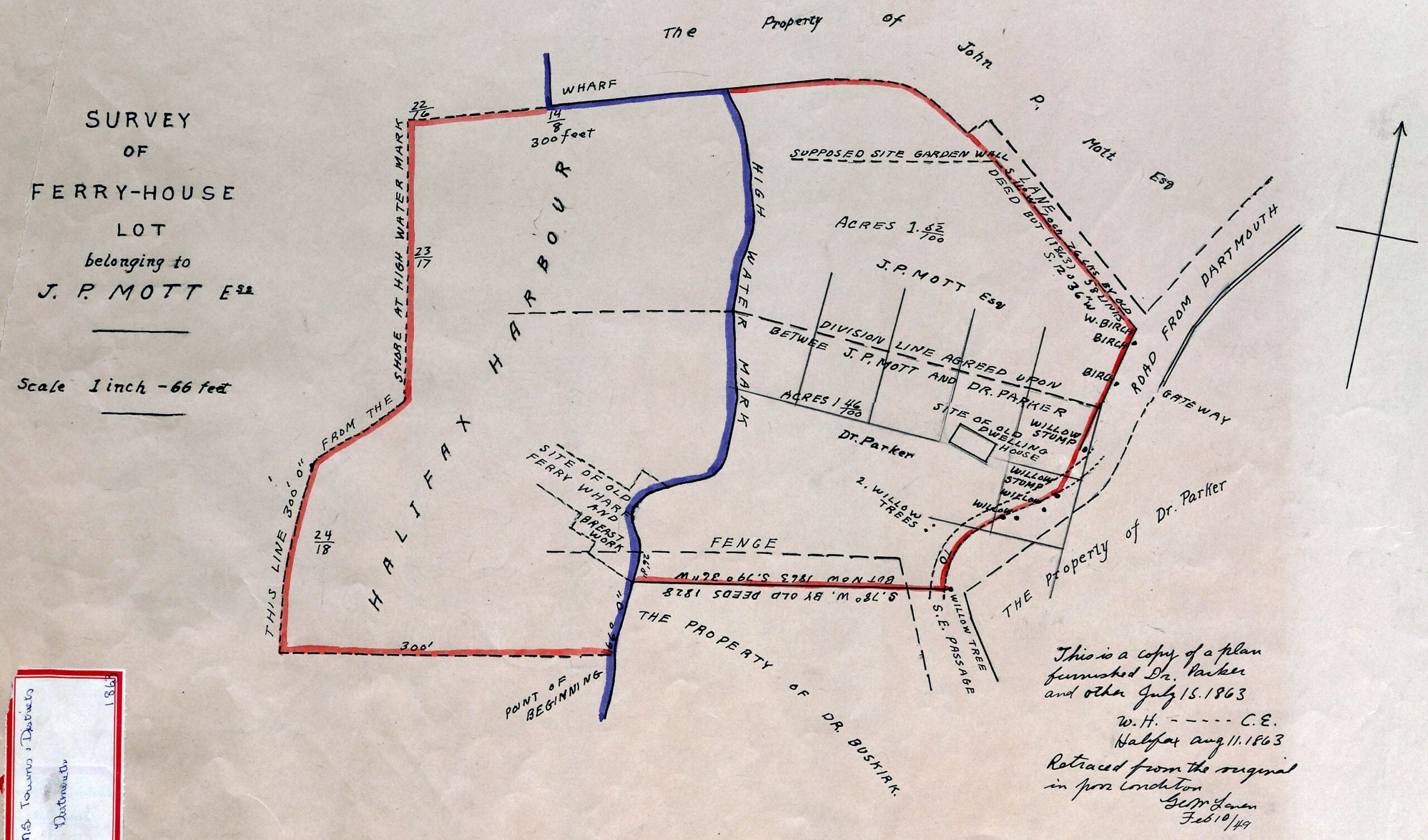
This map encompasses the bottom of Old Ferry Road once known as “Green Lane”, near Newcastle Street and Hazelhurst Street today. The (once massive) willow trees seen here are noted elsewhere.
See Also:
"Survey of Ferry-House Lot belonging to J.P. Mott Esq.", 1863 (1849). https://archives.novascotia.ca/maps/archives/?ID=799
Related posts:
- New Metropolitan Map There’s no shortage of street grid oddities on this map, post war yet pre-bridge, with two ferries crossing the harbor. Grid oddities include Broom St at the bottom of Maple St, Allison Ave and Prescott that connect Old Ferry Road...
- French Prison: Near old Ferry Road, Dartmouth Cove, probably built about 1793, afterwards J. P. Mott & Co. soap factory “Just a few years before its demolition. This historic building was erected in 1793 without additions [addition to the right was made by J.P. Mott & Company]. It was used as a barracks for French prisoners until September 1805. In...
- Hazelhurst From The Story of Dartmouth, by John P. Martin: This is John Mott’s residence “Hazelhurst” at 62-64 Pleasant Street undergoing demolition. Shown is the rear of the house with a back door for tradesmen. The driveway curved around to the main...
- Green Lane, Old Ferry Road, Lawrencetown Road Here is one of, if not the earliest plans available showing Old Ferry Road as far as Cole Harbour (at left), which was originally known as the road to Lawrencetown. Now, Old Ferry Road, Portland Street and Cole Harbour Road....
- Woodlawn, 1784 “Halifax, Feb (2?) 1784. This day the proprietors of a tract of land lying on the road to Lawrence Town came to agreement of partition of division according to the adjoining [??], viz. the land colored red was [??] by...
- Peninsula and harbour of Halifax A very detailed rendition of the Dartmouth shore from 1808. Skerry’s ferry at Ochterloney is seen as well as Creighton’s Ferry at the bottom of Old Ferry Road. Fort Duncan can be seen near where Shore Road meets Lyle Street...
- Dartmouth’s Town Plot From The Story of Dartmouth, by John P. Martin: “The town plot as laid out in 1750 comprised of 11 oblong-shaped blocks, mostly 400 feet long by 200 feet wide. Each building lot was 50 feet by 100 feet. Reference...
- Dartmouth, Aerial View St. Peter’s Church seen at upper middle, First Baptist at Victoria at middle right. Christ Church at middle, Victoria Road Baptist church is seen a block behind between it and its hall, Grace United Church is seen at middle bottom,...
- On the diurnal and annual variations of temperature at Halifax, Nova Scotia Monthly mean normal temperatures, at Halifax, for each of the twenty four hours, from Bi-hourly observations in the years 1867-1869 (°F): Hour Jan Feb Mar Apr May Jun Jul Aug Sep Oct Nov Dec Year Midn 18.83 20.90 24.12 33.05...
- Part of Dartmouth (Woodlawn), 1820 Here’s a quick coloration in order to hopefully ease legibility: Penhorn Lake can be seen at far left, Russell and Morris Lake along the bottom, Bell Lake at middle right. What is now Main Street, then known as “Road to...