
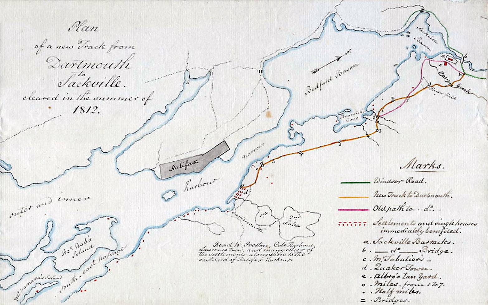
An interesting map for a few reasons, it specifies Pace’s stream, field and hill which is useful to pinpoint the bounds of the Township of Dartmouth, it also denotes what is typically shown as the Town Plot of Dartmouth as “Quakertown“, as distinct from “Dartmouth” at the foot of Old Ferry Road (as with a few other maps that centered Dartmouth around the Old Ferry, here and here).
The legend is as follows: green line being Windsor Road, Orange is the New Track to Dartmouth, pink being the Old path to Dartmouth. Red dots and marks indicating settlements and single houses immediately benefited (presumably from the new road).
Sackville Barracks is noted “a”, Sackville River bridge “b”, M. Sabatier’s is “c”, Quakertown is “d”, Albro’s Tanyard is “e”. Miles, from 1 to 7 are noted with “0”, half-miles with “.”, bridges with “=”.
From Old Ferry Road is noted “Road to Preston, Cole Harbour, Lawrencetown and many other settlements to the eastward of Halifax Harbour.”
The report is transcribed here as accurately as possible.
“Having completed the survey of the new track from Sackville, towards Dartmouth, and cleared the whole course, new and old, of brush, trees and logs, I beg leave agreeably to your Excellency’s direction, to report the particulars.
The old track begins at the Windsor Road at my gate – passes by my house – crosses Pace’s Brook – goes up a very steep and high hill, too steep to be ever rendered convenient or even practical for wheel carriages, – along and again down the same – then ascends another steep hill to f. – all this is through good land, and would make a very good road were it not for the hills are so very steep and high. – from f. to the bridge g. it is a most practicable barren of rocks; in most parts of which a shovel-full of earth can, with difficulty, be got. It is to avoid those hills and this barren the road from h. to g. will require to be turned.
The alteration proposed begins at my gate h. – passes on the eastern side of Pace’s hill, avoids the steeps and is a gentle acclivity to Pace’s field; – and thence either a level or a gentle declivity to f.; the quality of the land is sometimes very good hardwood, and an equal quantity of barren, but with abundance of earth – from f. the new track goes to the westward over Drillio’s tow hills; the land is excellent, with exception of 80 rods of practicable barren, but earth is abundant all the way – from i. to the bridge g. it is, in general, tolerable land, and, with trifling exceptions, level – but it is very stony with a few rocks, plenty of earth.
The remainder is the old track to Dartmouth – from the bridge g. the land is chiefly a barren to Albro’s Tanyard e.; it is, however, generally level with a few short steeps, some of which may be avoided and others rendered easy – from k. ( at 5 ¾ miles) to Dartmouth, it is a narrow but good road, generally, not more than 6 feet wide, and will serve as a sample of what would prove if so made all the way, a great accommodation to the public.
Mr. Samuel Albro, as overseer of highways, has eased my labor very much – he cleared the old path from g. towards Quaker town of brush and logs – the only trouble I had in this place was to chain it and fix up painted boards marked with the miles and half miles – others, also, where the track was doubtful from l to g.
On the whole I beg leave to recommend this road to your excellency’s patronage as a useful accommodation to persons living on both sides of the inner and outer harbours. To show the relative situations of these I have sketched the whole neighbourhood. I conjecture a very good road, as mentioned above, might be made for £350.
Sackville, October 12th 1812. William Sabatier, Commissioner.”
“Plan of the new track from Dartmouth to Sackville cleared during the summer of 1812” Sabatier, William. 1812. https://recherche-collection-search.bac-lac.gc.ca/eng/home/record?app=FonAndCol&IdNumber=4514427