
From The Story of Dartmouth, by John P. Martin:
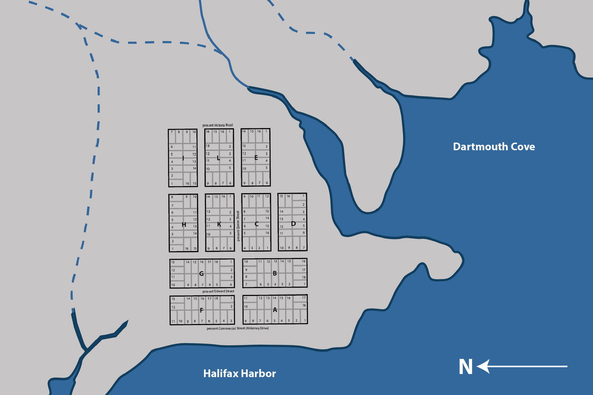
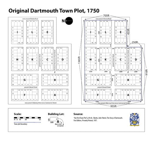
“The town plot as laid out in 1750 comprised of 11 oblong-shaped blocks, mostly 400 feet long by 200 feet wide. Each building lot was 50 feet by 100 feet. Reference to the cut shows that all the streets running north and south, lead to the point, which is the front part of the settlement. The northern boundary at the left side seems to be the present line of North Street. The southern boundary is the present Green Street, if it were produced through to Commercial Street (Alderney Drive). All the area from that line to the point would be the 10 acre grant of Benjamin Green.”
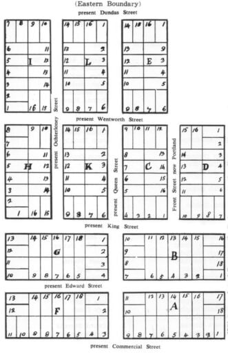
“The eastern boundary is at Dundas Street, and from there the present Queen Street extends through the middle of the plot to Commercial St. (Alderney Drive). But Portland and Ochterloney Streets come to a dead end at King Street. (No street names appear on the first plan).”
Was the eastern boundary actually at Dundas Street? I’ve always been a little confused by the original town plot and by the visual representation of it as seen above. That so much of the town was escheated and replotted with the arrival of the Quakers, that new street widths, block sizes and lot sizes were used thereafter doesn’t help the situation.
Martin notes the town plot consisted of “11 oblong blocks, mostly 400 feet long and 200 feet wide. Each building lot was 50 feet by 100 feet.”
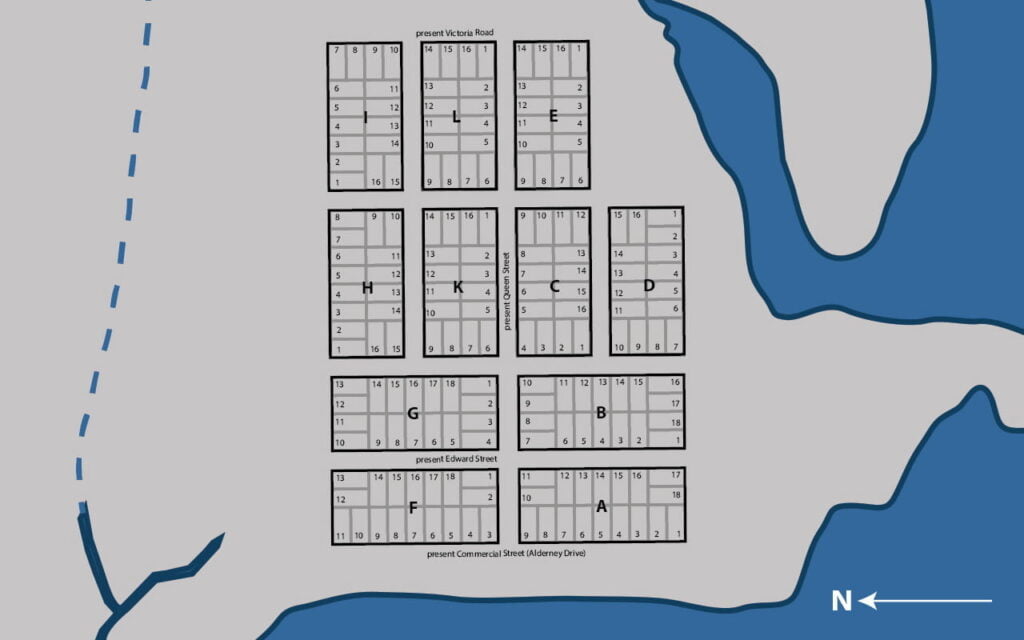
Only four of the blocks (“A”, “B”, “F” and “G”) had 18 building lots. Since the building lots are 100 x 50 feet, and the other 7 blocks (“C”, “D”, “E”, “H”, “I”, “K”, and “L”) had 16 building lots, perhaps this is the source of the discrepancy in block size?
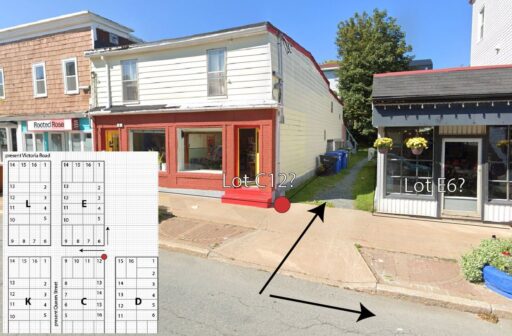
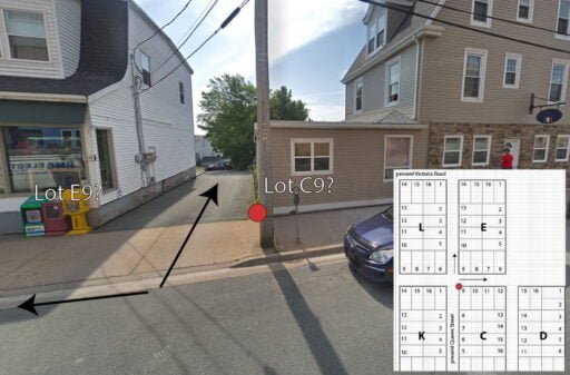
Martin points out that the part of Edward Street known as Chapel Lane (between Ochterloney and Queen) retains the original street widths, at 55 feet, so I used the South West corner of Chapel Lane and Queen with which to plot the old town plot.
200 feet west towards Alderney Drive (Block “F”), 450 feet North towards North Street (Block “F”), then 1365 feet East towards Victoria Road (passing Block “F”, “G”, “H” and “I”). I continued 710 feet south to Portland Street (Block “I”, “L” and “E”), 455 feet west along Portland Street (Block “E”, to the lane between 109 and 115 Portland Street), and then 255 feet south from there to Green Street (Block “D”). Plotting a further 910 feet west brings us back close to Alderney Drive (Blocks “D”, “B” and “A”); 450 feet north from there back to Queen Street (Block “A”, close to 55 feet from where we started).
It’s entirely possible my math is off or that I’m mistaken in my assessment, I certainly wouldn’t assume Martin missed something I picked up on, but it does seem to work out that it is Victoria Road that served as the eastern end of the town plot, and not Dundas Street.
The original 1750 Dartmouth town plot, the eastern boundary of which was thought to be at Dundas Street but may in fact be Victoria Road.
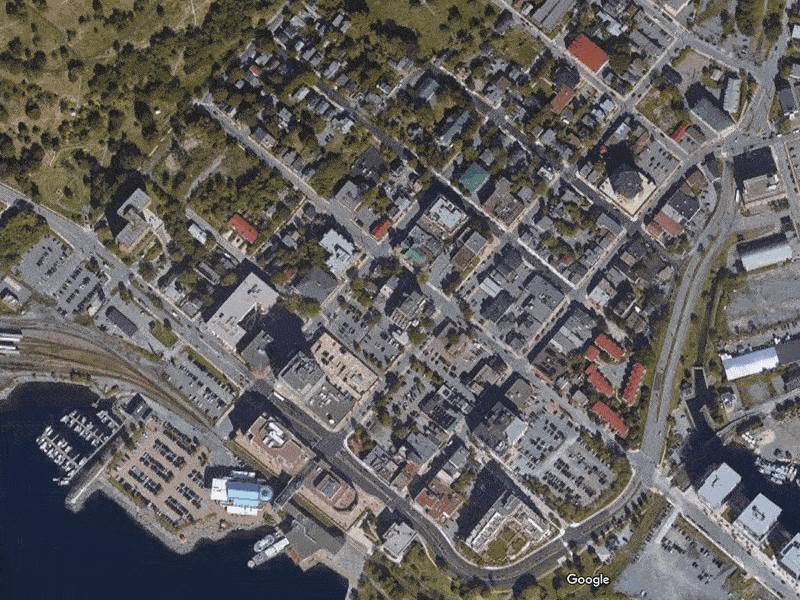
One thing that jumped out at me is the alley between 109 and 115 Portland Street (seen below, and at right the same alley from Queen Street). This would be at the south eastern corner of block “C”, lot 12 (or the north western corner of block “C”, lot 9 from the Queen Street side) — is this a remnant of the original town plot, proof that this was indeed the original town alignment? I’ve noticed a few other property alignment oddities that seem to back this up.
Dartmouth Settlers in 1750:
Reference the map above to locate by Block letter and lot number.
| Block Letter “A” | Block Letter “B” | Block Letter “C” | Block Letter “D” | ||||
| 1— | 1— | Matthew Staple | 1— | William Howard | 1— | Dr. John Baxter | |
| 2— | Josiah Rogerson | 2— | James McKensey | 2— | Abraham Mozar | 2— | Dr. John Baxter |
| 3— | James Lawrence | 3— | Ralph Nesham | 3— | Joseph Marken | 3— | |
| 4— | Joseph White | 4— | Wm. Manthorne | 4— | Albert Suremon | 4— | Robert Vowles |
| 5— | Daniel Breast | 5— | Thomas Hardin | 5— | Henry Claaser | 5— | John Hall |
| 6— | Joseph Scoffield | 6— | 6— | Abraham Walker | 6— | Cheyne Brownjohn | |
| 7— | Thomas Wiseman | 7— | Edward Potter | 7— | Joseph Gosterel | 7— | John Hill |
| 8— | Samuel Jones | 8— | Andrew Downing | 8— | 8— | Mary Clark | |
| 9— | 9— | William Moore | 9— | Thomas Stephens | 9— | Mary Clark | |
| 10— | William Cooper | 10— | Bruin Rankin | 10— | William Stephens | 10— | Mary Clark |
| 11— | 11— | Adolph Witherall | 11— | William Ross | 11— | Walter Clark | |
| 12— | John Dunnevan | 12— | Joseph Scott | 12— | Robert Brooks | 12— | Edward Stevens |
| 13— | William Steward | 13— | 13— | Reuben Hemsley | 13— | Thomas Bourn | |
| 14— | Daniel Budgate | 14— | 14— | 14— | Thomas Bourn | ||
| 15— | 15— | 15— | Dennis Doran | 15— | |||
| 16— | Josiah Rogerson | 16— | 16— | 16— | George Chreighton | ||
| 17— | 17— | ||||||
| 18— | John Dubois | 18— |
| Block Letter “E” | Block Letter “F” | Block Letter “G” | Block Letter “H” | ||||
| 1— | John Crooks | 1— | John MacDonald | 1— | 1— | ||
| 2— | 2— | Charles Germain (fenced) | 2— | William Carter | 2— | ||
| 3— | David McKey | 3— | Henry Sweetland | 3— | 3— | ||
| 4— | William Scraggs | 4— | Nathaniel Follet | 4— | 4— | William Nixon | |
| 5— | Samuel Blagdon | 5— | 5— | Eleazer Robinson | 5— | ||
| 6— | James Owen | 6— | John Orr | 6— | 6— | ||
| 7— | 7— | James Wright | 7— | 7— | |||
| 8— | Robert Sparks | 8— | 8— | 8— | |||
| 9— | 9— | 9— | 9— | ||||
| 10— | 10— | 10— | 10— | ||||
| 11— | John Hoopy | 11— | 11— | 11— | |||
| 12— | Robert Young | 12— | 12— | 12— | |||
| 13— | William Hall | 13— | 13— | 13— | |||
| 14— | 14— | 14— | 14— | ||||
| 15— | 15— | 15— | 15— | ||||
| 16— | Thomas Leuke | 16— | 16— | 16— | |||
| 17— | 17— | ||||||
| 18— | Joseph Cole | 18— |
| Block Letter “I” | Block Letter “K” | Block Letter “L” | |||
| 1— | 1— | 1— | |||
| 2— | 2— | 2— | |||
| 3— | 3— | 3— | |||
| 4— | 4— | 4— | Christian Bartlin by purchase | ||
| 5— | 5— | Edward Barton | 5— | ||
| 6— | 6— | Parkinson | 6— | John Williams | |
| 7— | 7— | ||||
| 8— | 8— | ||||
| 9— | Thomas Gunnel | 9— | |||
| 10— | Thomas Ruddles | 10— | |||
| 11— | John Orr | 11— | |||
| 12— | 12— | ||||
| 13— | 13— | ||||
| 14— | 14— | ||||
| 15— | 15— | ||||
| 16— | 16— |
“Memo— A fish lot to Ever Davison beginning at a stake on Mill River north 46° east 330 feet thence south 44° east to the beach 264 feet, thence on the Beach to above stake.
East and north in the vast township of Dartmouth, more large grants included those to Captain Clapham, William Magee, John Colebanks, James Quinn, Benjamin Bridges, Richard Prowse and others.
You will notice that in the lists of the 1750 grantees that most of them chose lots near the waterfront. Blocks like “G”, “H”, “I” and “K” were perhaps too close to the source of [indigenous] attacks. Or else, the Alderney group being fisherman, they naturally sought locations as near as possible to the beach. Ever Davison’s fish lot seems to have been in the vicinity of Weagle’s boat-building shop near Canal Street.”
“From that point all the way to Eastern Passage, larger areas ranging from 60 to over 200 acres, and fronting on the shore, were granted to people prominent among Cornwallis’ settlers. Adjoining Davison’s was that of Samuel Blackden (or Blagdon); next was John Salisbury at Hazelhurst Shore, then Charles Lawrence in the Department of Transport vicinity; William Steele, Richard Burkeley, Byron Finucane, Joseph Gerrish, Jacob Hurd, Charles Morris, Leonard Lockman, Rev. Aaron Cleveland, Rev. Mr. Tutty and others.
When the town was re-plotted for Nantucket whaling families in 1783, Portland and Ochterloney were extended through to Commercial St. (Alderney Drive), and the blocks were squared to have 240 feet on each side, as at present. The three oblong shaped blocks still standing in downtown Dartmouth have a driveway at the ends of Prince Street and Green Street, which suggests that all blocks of the new town were to be square shaped.
All the new lots measured 60 feet by 120 feet. Most of the streets were widened from 55 feet to 60. That part of Edward Street known as Chapel Lane seems to be the only relic of original street widths.”
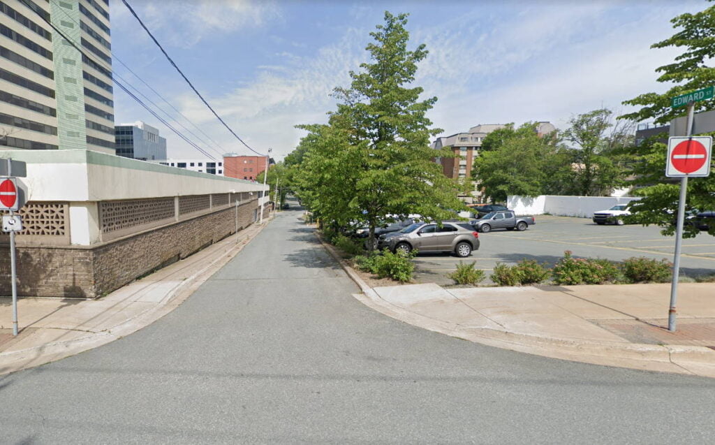
This is “Chapel Lane”, Edward Street from Queen to Ochterloney, relic of Dartmouth’s original (55 foot) street widths (Although Victoria Road, Whebby Terrace, and parts of North Street, all just outside the original town plot might also qualify). There were so many random ROWs in Dartmouth even in the 80s — between Victoria and Pine mid-block, between Wentworth and King in behind the ridge, many if not most of these have been reclaimed by adjoining property owners since, but perhaps were vestiges of escheatment too.
See also: