
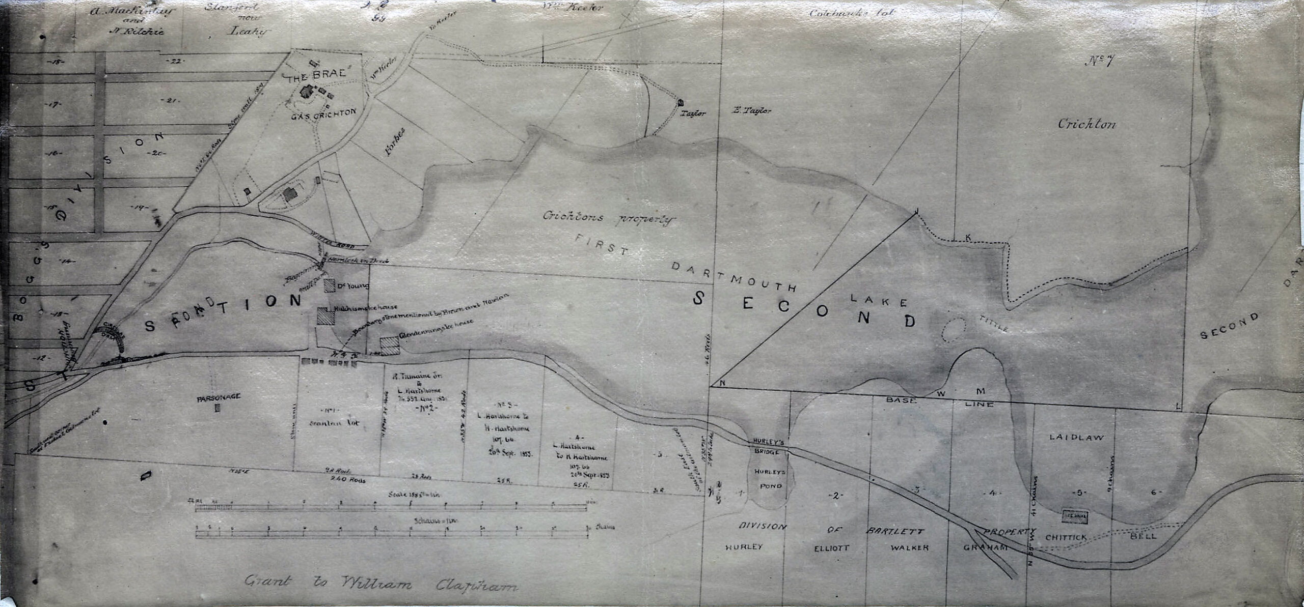
“Dartmouth, Property along the 1st Dartmouth Lake”, 1853. https://archives.novascotia.ca/maps/archives/?ID=730
Related posts:
- Dartmouth Property and Owners in Vicinty of Dartmouth Cove Lake and Canal “Dartmouth Property and Owners in Vicinty of Dartmouth Cove Lake and Canal”, November 10, 1804. https://archives.novascotia.ca/maps/archives/?ID=240...
- “Tract of land in Dartmouth, belonging to the estate of James Creighton…” “Tract of land in Dartmouth, Halifax County belonging to the estate of James Creighton, the elder and sold by his executors”, 1877. https://archives.novascotia.ca/maps/archives/?ID=962...
- Map of the Town of Dartmouth “Map of the Town of Dartmouth:, 1937. https://archives.novascotia.ca/maps/archives/?ID=1495...
- Town of Dartmouth “Town of Dartmouth”, 1952. https://archives.novascotia.ca/maps/archives/?ID=1638...
- Dartmouth, N.S. “Dartmouth, N.S.”, 1959. https://archives.novascotia.ca/maps/archives/?ID=1690...
- Twin Cities Map Metropolitan Halifax-Dartmouth Many communities noted on this map: Burnside, Shannon Park, Tufts Cove, Albro Lake, Port Wallis, Tam O’Shanter, Westphal, Graham Corner, Commodore Park, Southdale, Woodlawn Woodside, Ellendale, Bel Ayr Park and Wildwood Lake within the City of Dartmouth. A few peripheral...
- Halifax & Dartmouth City & Maritimes map “Halifax & Dartmouth City & Maritimes map”, 1976. https://archives.novascotia.ca/maps/archives/?ID=948...
- Dartmouth Waterworks, 1878 “Dartmouth Waterworks”, 1878. https://archives.novascotia.ca/maps/archives/?ID=1004...
- Dartmouth Lake Church “Photograph shows the congregation of Dartmouth Lake Church (now Victoria Road United Baptist Church).The church, also known in its early days as the African meeting house, was founded in 1844. Until 1906 the church was located at the corner of...
- Peninsula of Halifax (showing Dartmouth) “Peninsula of Halifax”, 1870. https://archives.novascotia.ca/maps/archives/?ID=897...