
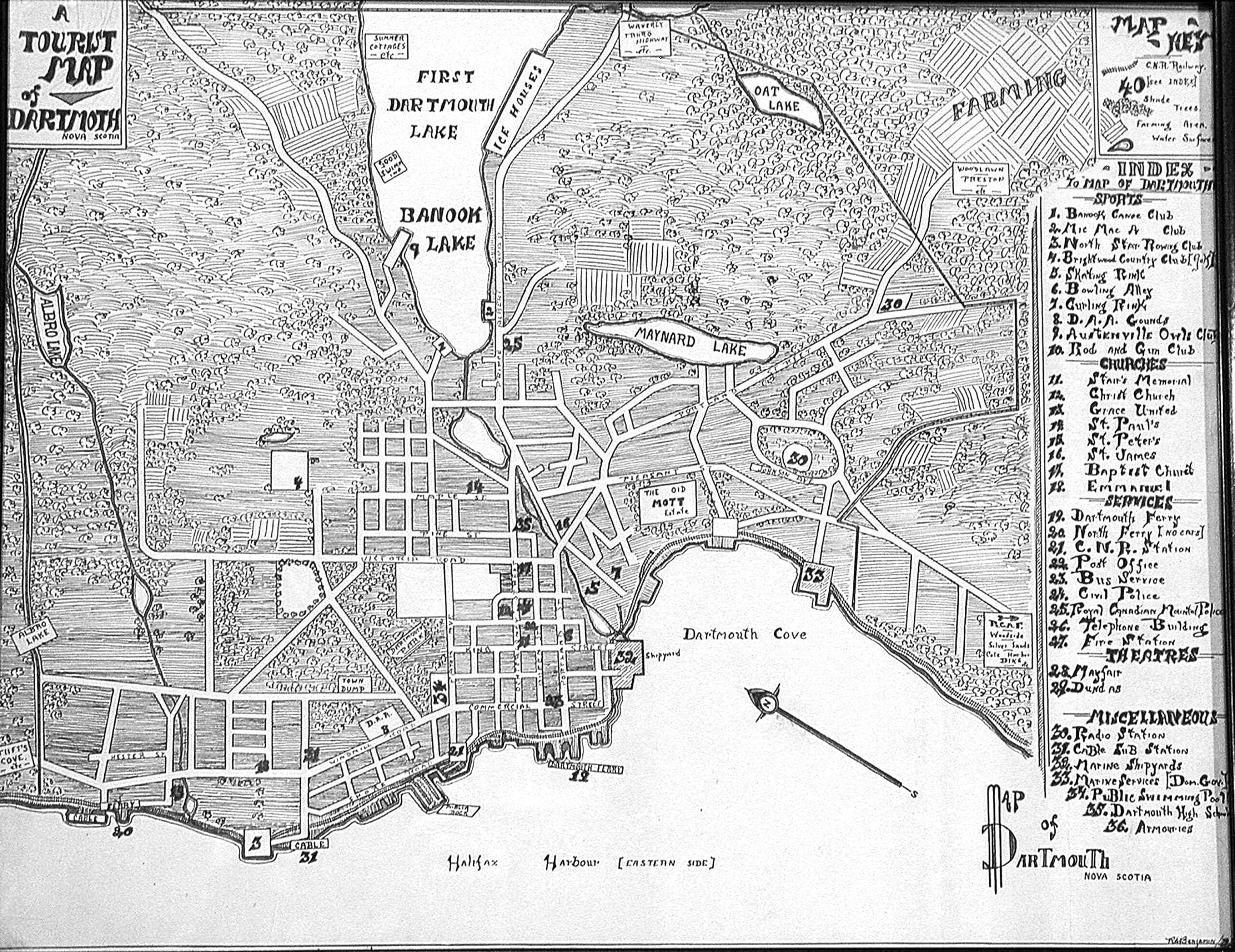
Of note at #25, an RCMP detachment within the Town on Prince Albert Road (perhaps at number 159?), as opposed to #24 on the map, the “Civil police”, located at Wentworth and Ochterloney.
“Tourist Map of Dartmouth”, 1939. https://memoryns.ca/a-tourist-map-of-dartmouth
Related posts:
- City of Dartmouth Police Station At the corner of Wentworth and Ochterloney Streets looking north east, land that has since passed into new hands and is now a residential building. Ochterloney Street between Dundas and Wentworth looking south, Town Hall was at left, Police Station...
- Halifax (and Dartmouth), Canada Among Dartmouth’s attractions noted: North of Park Avenue: North Ferry, St. Paul’s School, Stairs Memorial Church, Emmanuel Church, Park School and Victoria School, Dartmouth Common as well as Brightwood Golf course further down School Street. In or near Austenville: St....
- Five Corners Looking East, previous to the construction of the new Hawthorne School (now located in the empty field at middle-left) as well as the apartment building at Pleasant, Portland and Albert Street (in the bottom right). To avoid confusion, this is...
- September 14th, 1907 From The Story of Dartmouth, by John P. Martin: “This first picture was taken at the intersection of Prince Albert Road and Ochterloney Street on Saturday, September 14, 1907 (Below, as it looks in more modern times). The length of the...
- An Act relating to the Town of Dartmouth, 1939 c75 “An Act relating to the Town of Dartmouth”, 1939 c75...
- An Act Respecting the Metropolitan Area of Halifax and Dartmouth, 1939 c68 “An Act Respecting the Metropolitan Area of Halifax and Dartmouth”, 1939 c68...
- An Act relating to the Town of Dartmouth, 1939 c74 “An Act relating to the Town of Dartmouth”, 1939 c74...
- Ochterloney Street, Preston Road, No. 7 Highway From The Story of Dartmouth, by John P. Martin: The names of Ochterloney and Quarrell (now Queen) were commemorated by streets in downtown Dartmouth. The extension of the first named thoroughfare marked the beginnings of the present no. 7 highway....
- Dartmouth Tourist Bureau On Thistle Street in the Dartmouth Common, looking east, ballfield in behind....
- Dartmouth flood The results of an unwelcome guest, Hurricane Beth, in August of 1971....