
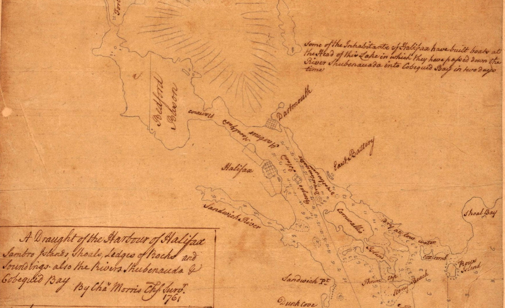
Morris, Charles. A draught of the harbour of Halifax, Sambro Islands, shoals, ledges of rocks, and soundings, also the rivers Shubenauda & Cobequid Bay. [1761] Map. Retrieved from the Library of Congress, <www.loc.gov/item/74691494/>
Related posts:
- A chart of the peninsula of Nova Scotia Morris, Charles. A chart of the peninsula of Nova Scotia. [1761] Map. Retrieved from the Library of Congress, <www.loc.gov/item/74691224/>...
- Southeast Coast of Nova Scotia Des Barres, Joseph F. W. The sea coast of Nova Scotia; exhibiting the diversities of the coast, and the face of the country near it: the banks, rocks, shoals, soundings, &c. Together with remarks and directions for the conveniency of...
- To his excellency Thomas Jefferson, esqr., President of the Congress, this chart of the United States of America: including Halifax, Havannah [Havana], New Providence, and all the northern parts of the West Indies Dartmouth and Indian Town! 😎 If only there was more detail of the settlements themselves. Fascinating to me that the only inset on this map is Halifax Harbor. To me it represents Jefferson’s viewport to 45°N, reflective of his notes...
- A plan of the harbour of Halifax A somewhat detailed representation of Dartmouth by Charles Morris showing what appears to be four blockhouses and what is perhaps the connecting palisade. Mills are also noted along with a windmill just beyond the mill stream, near what would be...
- Maps of Nova Scotia and Halifax harbor and view of lighthouse Maps of Nova Scotia and Halifax harbor and view of lighthouse. [Nova Scotia?: Producer not indicated, ?, 1840] Map. Retrieved from the Library of Congress, <www.loc.gov/item/2017585984/>...
- A plan of the harbour of Chebucto and town of Halifax One structure is noted at “Warrens point” near where the Marine Slips were located, what is now King’s Wharf in downtown Dartmouth. “Major Gilmots”, is listed, which should be Major (Ezekiel) Gilman, whose saw mill was erected not long after Halifax’s...
- A summary of colonial law “The colonies now belonging to the Crown of Great Britain, exclusive of those under the government of the East India Company, (to which this work does not profess to extend,) are as follows: In the West Indies and South America:...
- New England, New Scotland (Nova Scotia), and Newfoundland See also: Stirling, William Alexander, Earl Of, 1567 Or , Cartographer, and William Alexander Stirling. New England, Nova Scotia, and Newfoundland. [London: Publisher not indicated, ?, 1624] Map. Retrieved from the Library of Congress, <www.loc.gov/item/2018590035/>...
- A new and accurate map of the English empire in North America “The French claim all the country within the Hudson’s Bay Company’s southern limits and the brown line”, an entity just recently privatized. Perhaps this border shown here as the 45° latitude explains the location of the Old Annapolis Road which...
- A list of [Mi’kmaq] names of places, rivers, etc., in Nova Scotia “The following list of [Mi’kmaq] names of places, rivers, etc., in Nova Scotia and neighborhood was compiled, at my request, by Miss Elizabeth Frame, of Shubenacadie, for the library of the Massachusetts Historical Society, and was duly presented at the...